

Mori Atlas logo
Protected landscapeLittle Missouri National Grassland

Examining the geographic boundaries and working-landscape character of this expansive protected expanse

Little Missouri National Grassland: An Atlas of North Dakota Badlands and Prairie Landscapes

Spanning over a million acres in western North Dakota, Little Missouri National Grassland represents the largest national grassland in the United States. This protected landscape is defined by the dramatic interplay between vast, open mixed-grass prairie and deeply eroded badlands carved by the Little Missouri River. The terrain features colorful sedimentary rock formations, rugged buttes, and steep canyons that contrast sharply with the surrounding Great Plains. Serving as a backdrop for Theodore Roosevelt National Park, the area offers a unique look at how conservation, ranching, and energy development coexist within a large-scale western American ecosystem.

national grasslandmixed-grass prairiebadlandsGreat Plainsprairie conservationworking landscape

Little Missouri National Grassland

Protected landscape

Park overview

Structured park overview, official facts, and landscape profile for Little Missouri National Grassland

Little Missouri National Grassland park facts, protected area profile, and essential visitor context

Review the core facts for Little Missouri National Grassland, including designation, size, terrain, visitor scale, habitats, and operating context in one park-focused overview.

About Little Missouri National Grassland

Little Missouri National Grassland occupies a vast swath of western North Dakota where the northern Great Plains give way to a rougher, more dissected terrain known as the North Dakota badlands. Spanning more than a million acres across McKenzie, Billings, Slope, and Golden Valley counties, it is the single largest National Grassland in the United States and one of the defining public-land landscapes of the region.

The grassland is managed by the U.S. Forest Service as part of the Dakota Prairie Grasslands, a National Forest unit composed entirely of National Grasslands. Originally part of the historic Custer National Forest, it was established as a National Grassland in 1960 and shifted more explicitly toward prairie conservation and working-land management. Within its boundaries sit significant tracts of state-owned and privately owned land, much of it leased by ranchers for cattle grazing, which gives the area a strong ranching heritage alongside its ecological significance.

A central geographic feature is the Little Missouri River, which winds through the landscape and has been instrumental in shaping its terrain. Centuries of wind and water erosion have carved colorful badlands across much of the grassland, punctuating the otherwise open mixed-grass prairie with steep slopes, exposed bands of sediment, and rugged draws. Theodore Roosevelt National Park is enclaved within the larger grassland and managed by the National Park Service, creating a layered arrangement of protections in the same general region.

The grassland is also a working landscape shaped by modern energy development. Oil and gas exploration, extraction, and distribution infrastructure are widespread and have raised long-term concerns about impacts on soil, water, vegetation, and wildlife, including several threatened and endangered species. This blend of conservation purpose, ranching tradition, recreation, and industrial activity defines the contemporary identity of Little Missouri National Grassland.

Quick facts and research context for Little Missouri National Grassland

Little Missouri National Grassland is located in western North Dakota, spanning parts of McKenzie, Billings, Slope, and Golden Valley counties, in descending order of land area. At roughly one million acres, it is the largest of the twenty National Grasslands designated across the United States and forms the core of the broader Dakota Prairie Grasslands unit administered by the U.S. Forest Service.

The landscape combines mixed-grass prairie with extensive badlands terrain shaped by the Little Missouri River, and it shares a close geographic relationship with Theodore Roosevelt National Park, which lies enclaved within its borders. White Butte, the highest point in North Dakota, sits in the southeastern corner near the town of Amidon, underscoring the wide topographic range present within the grassland's boundaries.

Protection and recognition

Examine terrestrial protection scope and official recognition details.

Little Missouri National Grassland Protection Status and Designated Area Record

Little Missouri National Grassland maintains a defined terrestrial protection scope within its designated regional landscape. Verified conservation records assemble documented designation facts and management parameters for public reference.

Protection details

Protection scope
Terrestrial
Transboundary protection
No
Park context

Deeper park guide and search-rich context for Little Missouri National Grassland

Little Missouri National Grassland history, landscape, wildlife, and travel context

Explore Little Missouri National Grassland through its history, landscape character, ecosystems, wildlife, conservation priorities, cultural context, and seasonal travel timing in a structured park guide built for atlas discovery and search intent.

Why Little Missouri National Grassland stands out

Little Missouri National Grassland is best known for being the largest National Grassland in the United States and for its enormous expanse of mixed-grass prairie stitched together with deeply eroded badlands. Its colorful rock formations, river-carved canyons, and wind-shaped landforms give the otherwise open prairie a dramatic and varied topography unlike the flatter grasslands commonly associated with the Great Plains. The grassland is also notable for hosting Theodore Roosevelt National Park entirely within its outer boundaries, making it a backdrop landscape that surrounds one of the most iconic northern Great Plains parks. White Butte, North Dakota's high point, rises in its southeastern reaches, reinforcing the area's status as a landscape of both wide-open prairie and striking geologic relief.
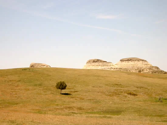
A wide, low-angle shot of the Little Missouri National Grassland, showing a solitary tree in the middle of a grassy, rolling prairie landscape with light-colored, eroded clay buttes in the background under a pale sky.
A lone tree stands against the backdrop of eroded clay buttes in the Little Missouri National Grassland.

Little Missouri National Grassland history and protected-area timeline

The lands that became Little Missouri National Grassland were historically part of the Custer National Forest, an early-twentieth-century Forest Service consolidation of forest reserves in the region. As the Forest Service's understanding of western land management evolved, much of the area's character came to be recognized as prairie and badlands rather than true forest.

On June 23, 1960, the area was formally designated Little Missouri National Grassland, separating it from the broader Custer National Forest framework and aligning it with the emerging National Grassland system. The grassland was later organized together with other prairie units in the region into the Dakota Prairie Grasslands, a consolidated National Forest unit composed entirely of National Grasslands and administered from offices in Bismarck, with ranger district offices in Dickinson and Watford City.

Over time, the grassland's identity has been shaped by a continuing mix of ranching, recreation, wildlife habitat conservation, and energy development, reflecting the long transition of the northern Great Plains from open frontier to a mosaic of working and protected landscapes.

Little Missouri National Grassland landscape and geographic character

The landscape of Little Missouri National Grassland is defined by the interplay between open mixed-grass prairie and a rugged badlands zone carved by centuries of erosion. The Little Missouri River meanders through the area and has been the principal force in shaping the canyons, buttes, and gullies that punctuate the broader plain. The result is a terrain that shifts quickly from rolling grassland to steep, colorful exposures of sedimentary rock.

The northern Great Plains setting gives the area a wide, open character, while the badlands introduce abrupt changes in elevation and dramatic vistas. White Butte, North Dakota's highest point, rises in the southeastern corner of the grassland near the town of Amidon, marking one of the most striking topographic features in the region. Farther west, the terrain merges with the rift of badlands and prairie that continues into adjacent states.

Across the grassland, smaller draws, butte tops, and scattered breaks break up the otherwise continuous sea of grass, while the river corridor adds a sinuous green and wooded thread through an otherwise arid-looking environment. This combination of openness and dissection gives the grassland a scenic variety that goes well beyond the flat prairie stereotype.

Little Missouri National Grassland ecosystems, habitats, and plant life

Ecologically, Little Missouri National Grassland is a mixed-grass prairie system that brings together both long-grass and short-grass species typical of the northern Great Plains. The drier western sections favor shorter, hardier grasses, while moister pockets and river bottoms support taller and denser stands, creating a transitional zone between the tallgrass prairies to the east and the shortgrass steppe farther west.

Badlands and breaks add variety to the vegetation mosaic, with exposed slopes, shrubs, and scattered woodlands along the Little Missouri River providing habitat structure that differs sharply from the open uplands. This blend of prairie types, riparian corridors, and eroded terrain supports a wide range of plant communities across the grassland's vast area.

The combination of public and private land, much of it leased for grazing, means the landscape retains a working pastoral character while still functioning as a continuous ecological unit. Wet draws, river bottoms, and ponderosa fringes contribute to habitat diversity, while the sheer spatial scale of the grassland gives it significance far beyond any single site.

Little Missouri National Grassland wildlife and species highlights

The grassland's mixed-grass prairie and badlands mosaic support a typical northern Great Plains wildlife community, including grassland songbirds, raptors, mule deer, pronghorn, and various small mammals adapted to semi-arid prairie conditions. The river corridor of the Little Missouri adds riparian species and seasonal habitat for migratory birds, while the badlands offer nesting and shelter opportunities for cliff- and canyon-dwelling fauna.

Species of conservation concern, including threatened and endangered species recognized under federal listings, are present within the grassland. Their presence has heightened attention to the habitat effects of oil and gas exploration, grazing patterns, and other land uses across the area. Wildlife viewing is closely tied to the broader experience of the surrounding Theodore Roosevelt National Park, which shares much of the same ecological context.

The sheer size of the grassland, combined with its varied terrain, gives it substantial importance for wide-ranging species and for maintaining ecological connectivity across a region where native prairie has been extensively altered by agriculture and development.

Little Missouri National Grassland conservation status and protection priorities

As the largest National Grassland in the United States, Little Missouri National Grassland plays an outsized role in conserving a substantial block of northern mixed-grass prairie. Its scale helps protect ecological processes, habitat continuity, and native grassland communities that have been heavily reduced elsewhere on the Great Plains. The presence of Theodore Roosevelt National Park within its boundaries further reinforces its conservation importance.

The grassland's value is closely tied to its working-landscape character. Cattle grazing on leased state and private inholdings is part of the established land-use pattern, and management seeks to balance that tradition with habitat conservation. At the same time, the area faces significant pressure from oil and gas development, including exploration, extraction, and associated infrastructure, which can affect soils, water quality, vegetation, and sensitive wildlife.

Conservation management addresses these competing uses through the Forest Service's oversight of the Dakota Prairie Grasslands, with attention to grazing allotments, energy leases, wildlife habitat, and erosion-prone badlands terrain. The grassland stands as a major example of how federal prairie lands are managed for multiple objectives simultaneously, rather than as purely wilderness or strictly protected reserves.

Little Missouri National Grassland cultural meaning and human context

The cultural identity of Little Missouri National Grassland is strongly tied to the cattle ranching heritage of the western North Dakota plains. Large portions of the area are state or privately owned and have long been leased for grazing, embedding ranching families and rural communities into the everyday landscape of the grassland.

The region is also closely associated with the legacy of Theodore Roosevelt, whose experiences ranching in the nearby badlands shaped his conservation philosophy and led to the eventual creation of the national park that now sits within the grassland's borders. Local gateway communities such as Medora, Amidon, Dickinson, and Watford City serve as administrative, supply, and visitor-service hubs tied to the grassland's working and recreational life.

Energy development, particularly oil and gas, has become an increasingly visible part of the modern cultural and economic context, influencing land use, community prosperity, and the ongoing debate over how to balance extraction with conservation in the northern Great Plains.

Top sights and standout views in Little Missouri National Grassland

Highlights of Little Missouri National Grassland include its sheer scale as the largest National Grassland in the country and its dynamic badlands-and-prairie scenery. The colorful, wind- and water-carved terrain gives the area a topographic variety unusual for a Great Plains landscape, with the meandering Little Missouri River serving as the central organizing feature.

The grassland's enclosing relationship with Theodore Roosevelt National Park, the presence of White Butte as North Dakota's highest point, and its mix of ranching heritage with ongoing energy development round out a distinctive profile. Together these traits make the area a major showcase of how large-scale prairie conservation works alongside traditional land uses in the modern American West.

Best time to visit Little Missouri National Grassland

The most rewarding times to experience Little Missouri National Grassland generally align with the milder seasons of the northern Great Plains. Late spring and early summer bring green-up of the mixed grass and active wildlife, while the cooler, drier days of early fall often offer comfortable conditions for driving and viewing the badlands under softer light.

Summer can be hot and at times stormy, while winter brings cold temperatures and snow that close off access in places and mute the colors of the badlands. Visitors focused on wildlife and comfortable travel often favor the shoulder seasons, when草原 and badland vistas feel especially vivid, though each season offers a different expression of the same wide prairie landscape.

Monthly climate preview

Long-term temperature and precipitation patterns across the representative coordinate

Little Missouri National Grassland Climate Normals and Weather by Month

Representative coordinates record distinct annual shifts between subzero winter minima and warm summer maximums alongside varying monthly precipitation rates. Analyzing complete monthly climate normals reveals detailed long-term weather patterns across the protected landscape.
Annual mean7 °C
-7 °C23 °C
Jan-7°
Feb-5°
Mar
Apr
May13°
Jun19°
Jul23°
Aug22°
Sep15°
Oct
Nov-1°
Dec-6°
Warmest month
July

22.8 °C

Coolest month
January

-7.5 °C

Wettest month
June

2.5 mm/day

Driest month
January

0.4 mm/day

Park location guide

Geography guide, regional context, and park location map for Little Missouri National Grassland

Little Missouri National Grassland park geography, regions, and map view in United States of America

Understand where Little Missouri National Grassland sits in United States of America through a broader geographic reading of the surrounding landscape, nearby location context, and its mapped position within the national park landscape.

How Little Missouri National Grassland fits into United States of America

The United States of America is a federal presidential republic and one of the world's largest countries by area and population. It consists of 50 states across a vast territory spanning multiple time zones, with its capital in Washington, D.C. and largest city in New York City. The nation has a diverse economy, influential political system, and significant cultural and military presence globally.

Wider geography shaping Little Missouri National Grassland in United States of America

The United States occupies a vast territory in North America, bordered by Canada to the north and Mexico to the south. The 48 contiguous states stretch from the Atlantic to the Pacific Ocean, while Alaska occupies the northwestern region and Hawaii is an archipelago in the Pacific. The country encompasses diverse terrain including the Rocky Mountains, Appalachian Mountains, Great Plains, and extensive river systems.

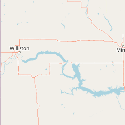
Map view of Little Missouri National Grassland

Use this park location map to pinpoint Little Missouri National Grassland in United States of America, understand its exact geographic position, and read its mapped placement within the surrounding landscape more clearly.

Pigeon | © OpenStreetMap contributors

Location context for Little Missouri National Grassland

North Dakota
Recorded earthquake history

Explore Historical Earthquake Records for Little Missouri National Grassland

Review the documented seismic history associated with the diverse terrain of the Little Missouri National Grassland. The MoriAtlas earthquake catalogue offers structured access to historical event records, providing clear insight into recorded activity levels and epicentre proximity across this significant northern Great Plains protected landscape.

Little Missouri National Grassland Earthquake History

Catalogued events

1 event

Strongest magnitude

Magnitude 3.3

Most recent event

Sep 28, 2012

This history includes earthquakes recorded inside the park or within 50 km of its borders

Visual references showcasing badlands terrain, mixed-grass prairie, and protected habitats.

Little Missouri National Grassland Photos and Scenery: Exploring the Badlands Landscape

Little Missouri National Grassland images reveal a diverse protected landscape defined by eroded buttes, canyons, and wide-open northern Great Plains terrain. Examining these visual records helps researchers understand the complex topography and working character of the largest national grassland.

A wide, low-angle shot of the Little Missouri National Grassland, showing a solitary tree in the middle of a grassy, rolling prairie landscape with light-colored, eroded clay buttes in the background under a pale sky.

Park atlas

Compare regional badlands terrain and connected northern Great Plains landscapes

Explore Parks Near Little Missouri National Grassland and Surrounding Protected Areas

Browse nearby national parks and protected areas sharing the distinctive badlands topography and mixed-grass prairie of western North Dakota. Continuing across regional reserves provides broader geographic context for prairie conservation and eroded canyon ecosystems.
National parkNorth Dakota
Park boundaries overlap#1 closest

Southeast

Theodore Roosevelt National Park: Mapped Protected Landscape in North Dakota

Explore the geography and protected natural boundaries.

Theodore Roosevelt National Park represents a distinct protected landscape within North Dakota, offering a valuable entry point for exploring its unique geographic setting. This page provides a concentrated view of the park's mapped boundaries and its contribution to regional natural context. It is designed for users seeking detailed atlas-level information and a clear understanding of the park's protected-area status and geographic significance within the United States.

Area
285.08 km²
Established
1978
IUCN
II
Visitors
668.7K annual
Protected landscapeSouth Dakota
64 km away#2 closest

Southeast

Grand River National Grassland: Protected Landscape and Regional Geography in South Dakota

Mapped prairie, riparian corridors, and badland terrain.

Grand River National Grassland represents a complex protected landscape in South Dakota. Managed by the U.S. Forest Service, this area features diverse landforms including sand dunes, claypan playas, and green ash draws. This record provides a structured geographic overview of the grassland mosaic, spanning Perkins, Corson, and Ziebach counties with significant cultural ties to local tribal lands.

Area
626.38 km²
Established
1960
Relief
Lowland
Climate
Temperate
Wildlife reserveNorth Dakota
About 65 km away#3 closest

Northeast

Lostwood Wilderness Wildlife Reserve and Prairie Pothole Landscape Geography

Protected northern mixed grass prairie in North Dakota

Lostwood Wilderness protects a unique mosaic of native grasslands and shallow wetlands in northwestern North Dakota. As an essential part of the National Wilderness Preservation System, it preserves a roadless, undeveloped window into the prairie pothole region, offering a clear view of the natural terrain and conservation character of the northern Great Plains.

Area
22.57 km²
Established
1975
IUCN
Ib
Relief
Lowland
Wildlife reserveNorth Dakota
113 km away#4 closest

Southeast

Cedar River National Grassland: A Protected Prairie Landscape in Southern North Dakota

Mixed-grass prairie geography and regional watershed context

Cedar River National Grassland preserves a representative mosaic of upland plains and rolling hills in southern North Dakota. As part of the wider Dakota Prairie Grasslands, this wildlife reserve provides insight into northern prairie topography and intermittent stream ecosystems that define the regional character of the Great Plains.

Area
27.18 km²
Relief
Lowland
Climate
Temperate
Scope
Terrestrial
Protected landscapeWyoming
190 km away#5 closest

South

Thunder Basin National Grassland: A Protected Landscape in the Wyoming Powder River Basin

Mapping the prairie and sagebrush mosaic of northeastern Wyoming

Thunder Basin National Grassland is a sprawling, federally protected territory in northeastern Wyoming that functions as a critical ecotone between the Great Plains and the Rocky Mountain region. Its landscape is characterized by wide-open vistas, intricate sedimentary bluffs, and diverse habitats shaped by natural disturbance patterns and ongoing grassland management. This record outlines the geography, terrain features, and protected boundaries that define this essential segment of the American West.

Area
2,215.65 km²
Established
1960
Relief
Upland
Climate
Arid
Wildlife reserveSaskatchewan
About 205 km away#6 closest

North

Moose Mountain Creek National Wildlife Area Protected Habitat and Geographic Atlas

A preserved prairie wetland complex in southeastern Saskatchewan.

Moose Mountain Creek National Wildlife Area is a federal reserve in Saskatchewan that protects a rare assembly of four distinct habitat types. The land features a functional mix of freshwater marshes, native mixed-grass prairie, and trembling aspen groves. This structured protected area highlights the importance of preserving remnant prairie ecosystems within a broader agricultural region, providing a critical baseline for understanding local geography.

Area
1.63 km²
Established
2025
IUCN
IV
Relief
Lowland
National parkSaskatchewan
229 km away#7 closest

Northwest

Grasslands National Park: Saskatchewan Protected Landscape Atlas

Discover its mapped boundaries and regional geographic context.

Grasslands National Park represents a vital component of protected lands in Saskatchewan, Canada, offering rich opportunities for atlas-based geographic exploration. This detail page provides specific insights into the park's mapped boundaries, its natural terrain, and its role as a national park within the broader regional geography. Understand how this protected landscape fits into the larger atlas of Canadian conservation areas and discover its unique geographic identity.

Area
907 km²
Established
1981
IUCN
II
Visitors
19.7K annual
Wildlife reserveSaskatchewan
About 268 km away#8 closest

North

Zugvogelschutzgebiet Indian Head: A Wildlife Reserve in Saskatchewan Prairie Landscapes

Examining mapped boundaries and protected wetland terrain

Zugvogelschutzgebiet Indian Head represents a significant conservation footprint within the Saskatchewan prairie region. This wildlife reserve integrates managed wetlands and historic nursery grounds, showcasing how agricultural landscapes support migratory bird populations. Gain insight into its terrain, ecoregion placement, and the geographic history of these protected lands through our structured atlas data.

Area
0.32 km²
Established
1924
Relief
Lowland
Scope
Terrestrial

Common questions about visiting, size, designation, and location context for Little Missouri National Grassland

Little Missouri National Grassland FAQs for park facts, access, geography, and protected area context

Find quick answers about Little Missouri National Grassland, including protected-area facts, park geography, trail and visitor context, and how the park fits into its surrounding country and regional landscape.
MoriAtlas Explorer

Continue Your Protected Areas Search Across the Global Atlas

Deepen your exploration by continuing the structured search for national parks and protected areas worldwide. Utilize the comprehensive filtering capabilities to compare different conservation landscapes and refine your understanding of global park geography. Discover more about the distribution and characteristics of protected natural areas.

Global natural geography