Mori Atlas logo
Marine protected areaLoch Creran

Understanding the tidal basins, Atlantic oakwoods, and sheltered marine geography of Argyll and Bute

Loch Creran Marine Protected Area: A Geographic Survey of Coastal and Woodland Landscapes

(Loch Creran Nature Conservation Marine Protected Area)

Loch Creran represents a unique convergence of Highland ecology and marine conservation in the Argyll and Bute region. This narrow sea loch features classic fjord characteristics, including deep basins punctuated by shallow tidal sills that support rare flame shell beds and horse mussel reefs. Beyond the seabed, the protected area integrates with Glasdrum Wood, providing a contiguous landscape that spans from coastal salt-water inlets to protected Atlantic oakwood habitats.

sea lochmarine protected areaflame shell bedshorse mussel reefsAtlantic oakwoodSpecial Area of Conservation

Loch Creran

Marine protected area

Park overview

Structured park overview, official facts, and landscape profile for Loch Creran Marine Protected Area

Loch Creran Marine Protected Area park facts, protected area profile, and essential visitor context

Review the core facts for Loch Creran Marine Protected Area, including designation, size, terrain, visitor scale, habitats, and operating context in one park-focused overview.

About Loch Creran Marine Protected Area

Loch Creran lies on the western seaboard of Scotland, cutting into the Argyll and Bute mainland from the Lynn of Lorne. It is a classic sea loch: a glacially carved inlet with steep shorelines, a narrow entrance partly screened by the island of Eriska, and a long, tapering shape that runs roughly east from its mouth toward Invercreran at its head. The A828 road crosses the loch at Creagan, one of its narrowest and shallowest points, connecting the communities of Benderloch on the south shore with Appin to the north.

The physical shape of the loch is central to its ecological character. At both Eriska and Creagan the loch pinches in and shoals, which accelerates tidal currents as water moves in and out with the tide. These accelerated, well-mixed waters deliver oxygen and suspended nutrients to the seabed, supporting dense communities of flame shells and horse mussels. Between the two sills, deeper and more sheltered basins collect finer sediments and quieter water, providing conditions suited to burrowing species such as Norway lobster and to fields of seapens.

In 2014 the Scottish Government designated the entire loch, encompassing about 1,200 hectares, as a Nature Conservation Marine Protected Area. The MPA is managed by Marine Scotland and is also recognised as a Special Area of Conservation. Within the protected area, fishing methods that could damage the sensitive seabed habitats are restricted, although rod-and-line fishing and creeling for lobster and crab remain permitted. The international IUCN classifies the site as a Category IV protected area, reflecting its focus on managing specific habitats and species rather than broader wilderness preservation.

The protected area's identity is not purely marine. At the head of the loch, the River Creran enters the sea beside Glasdrum Wood National Nature Reserve, a remnant of Atlantic oakwood that has long been recognised for its lichen, butterfly, and otter populations. The combination of marine inlet, forested river mouth, and surrounding Highland landscape gives Loch Creran a compact but layered protected landscape, rare in combining internationally important seabed habitats with adjacent ancient woodland within a single, easily understood site.

Quick facts and research context for Loch Creran Marine Protected Area

Loch Creran is a sea loch roughly 10 kilometres long on Scotland's west coast, lying in Argyll and Bute between Benderloch and Appin. Its narrow, fjord-like form creates alternating shallow sills and deeper basins that drive distinctive tidal patterns on the seabed.

The entire loch was designated a Nature Conservation Marine Protected Area by the Scottish Government in 2014, covering around 1,200 hectares of sea floor, and is classified as an IUCN Category IV protected area. It is listed as a Special Area of Conservation, and seabed-disturbing fishing gear is restricted within its boundaries.

Protection and recognition

Marine protected area designation details established in 2014 with recorded recognition sources.

Loch Creran Protection Status, Designation History, and Natura 2000 Recognition

Loch Creran holds a documented marine protection status established in 2014, incorporating verified Natura 2000 recognition records within its designated scope. Researchers and conservation analysts examine these official administrative listings to review international designation history and management frameworks.

International recognition

Protection details

Protection scope
Marine
Designated year
2014
Transboundary protection
No
Park context

Deeper park guide and search-rich context for Loch Creran Marine Protected Area

Loch Creran Marine Protected Area history, landscape, wildlife, and travel context

Explore Loch Creran Marine Protected Area through its history, landscape character, ecosystems, wildlife, conservation priorities, cultural context, and seasonal travel timing in a structured park guide built for atlas discovery and search intent.

Why Loch Creran Marine Protected Area stands out

Loch Creran is especially known for being one of the most important sites in the UK for flame shells, a delicate bivalve whose hinged beds create miniature reef-like structures on the seabed. Closely associated horse mussel reefs add to the loch's reputation as a stronghold for fragile, slow-growing marine habitats. Equally distinctive is Glasdrum Wood at the head of the loch, one of the internationally important remnants of Atlantic oakwood in Scotland. The combination of sheltered marine basins, tidal sills, and adjoining ancient woodland gives the protected area a layered identity that is unusual for a relatively compact stretch of coast.
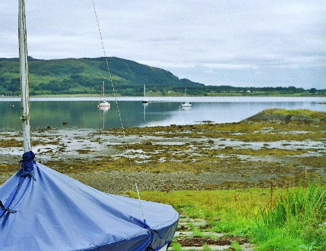
A covered sailboat sits in the foreground on a grassy bank at low tide, with the calm water of a sea loch and distant green hills under an overcast sky in the background.
A view across the tidal waters of Loch Creran toward the hills of Benderloch, with a covered boat in the foreground.

Loch Creran Marine Protected Area history and protected-area timeline

Loch Creran's conservation significance was built up over decades of marine survey work that revealed its unusual seabed communities. The loch's flame shell beds and horse mussel reefs were identified as among the most extensive and best-developed examples of these vulnerable habitats in the United Kingdom, while the loch's sills and basins were also recognised for their quaternary geological interest. Local woodland at the loch's head, particularly Glasdrum Wood, had earlier been recognised for its Atlantic oakwood values and designated as a National Nature Reserve managed by Scottish Natural Heritage.

In 2014, drawing on this accumulating scientific understanding, the Scottish Government formally designated the entire loch as a Nature Conservation Marine Protected Area. The designation brought the seabed under a management regime that restricts bottom-disturbing fishing gear, while still allowing traditional low-impact activities such as rod-and-line fishing and creeling. The site also gained recognition as a Special Area of Conservation and was classified internationally by the IUCN as a Category IV protected area, placing it within the broader UK and European networks of nature conservation sites.

Loch Creran Marine Protected Area landscape and geographic character

Loch Creran has the classic profile of a Scottish sea loch: a long, narrow inlet with steep forested shorelines, a single navigable channel, and a sheltered entrance screened by the island of Eriska. It runs roughly eastward from its mouth on the Lynn of Lorne to its head near Invercreran, a distance of about 10 kilometres. The village of Barcaldine sits on the south shore, while Appin lies along the north side and Benderloch covers the broader southern hinterland.

The bathymetry of the loch shapes the way it looks and behaves as landscape. At Creagan, where the A828 road bridges the narrowest point, and again near Eriska at the mouth, the seabed rises into shallow sills. Between these sills lie deeper basins where finer sediments settle out of the water. This alternation of fast-moving shallow water at the narrows and quieter deeper water in the middle gives the loch both its visible form and its underlying ecological structure.

Above the waterline, the loch is flanked by the wooded ridges and farmland of the western Highlands. The River Creran delivers freshwater from the surrounding hills into the head of the loch, where it meets Glasdrum Wood, an Atlantic oakwood reserve on steep ground above the shore. The overall landscape combines sheltered sea, forested shoreline, and Highland hinterland in a way that rewards both coastal and inland exploration.

Loch Creran Marine Protected Area ecosystems, habitats, and plant life

The marine habitats of Loch Creran are arranged in a clear pattern that mirrors the shape of the seabed. On the shallow, current-swept sills at Eriska and Creagan, dense beds of flame shells and horse mussels dominate. The two species complement each other: flame shells form delicate hinged clusters using byssal threads, while horse mussels build more robust clumps that can modify the surrounding sediments. Together they create biogenic reef-like structures that are slow to form and easy to damage.

In the deeper, calmer basins between the sills, finer muds accumulate and support a different community. Norway lobster live buried in these sediments, and seapens, colonial filter-feeding animals related to soft corals, stand upright in the mud. The contrast between the high-energy, biodiverse sills and the quieter, burrowing-fauna-rich basins is one of the defining features of the loch's marine nature.

At the head of the loch, the freshwater input of the River Creran borders Glasdrum Wood National Nature Reserve. This woodland is one of the surviving examples of Atlantic oakwood, a temperate rainforest habitat rich in mosses, lichens, and ferns. It has particular value for invertebrates, including the rare chequered skipper butterfly, and supports otters along the river and shoreline. The combination of marine and woodland habitats within a single protected area gives Loch Creran an unusually broad ecological profile.

Loch Creran Marine Protected Area wildlife and species highlights

Loch Creran's most celebrated wildlife lives on and in the seabed. Flame shells are the loch's signature species: small bivalve molluscs whose populations form extensive beds that filter the water and bind sediments. Horse mussels are a close companion, larger and longer-lived bivalves whose reefs add structural complexity to the seabed. Together, these species underpin a wider community of worms, crustaceans, and other invertebrates that depend on the habitats they create.

The deeper basins between the sills are inhabited by Norway lobster, a commercially valuable shellfish that spends much of its life within burrows in soft sediment, and by seapens, which resemble antique quills rising from the seabed. Tidal currents at the loch's narrows also concentrate plankton and nutrients, supporting fish populations that in turn attract seabirds and marine predators.

On shore, the most visible mammalian wildlife is the otter, which uses both the River Creran and the sheltered margins of the sea loch. Glasdrum Wood at the head of the loch adds woodland wildlife to the mix, including woodland birds and the chequered skipper, a butterfly whose UK distribution is concentrated in this part of western Scotland. The mixture of marine and woodland species gives visitors and researchers a wide suite of wildlife to encounter in a compact area.

Loch Creran Marine Protected Area conservation status and protection priorities

Loch Creran was designated a Nature Conservation Marine Protected Area in 2014 in response to the international importance of its seabed habitats. Its flame shell beds were among the largest known in the United Kingdom, and its horse mussel reefs, Norway lobster grounds, and seapen communities were recognised as vulnerable features requiring active management. The loch's quaternary geological features, shaped by past changes in sea level and ice cover, added a further reason for protection.

The designation restricts fishing gears that can damage the seabed, while still allowing rod-and-line fishing and creeling, reflecting the site's integration into a working coastal community. Marine Scotland manages the site, which is also designated as a Special Area of Conservation under European nature conservation law and is classified by the IUCN as a Category IV protected area focused on habitat and species management.

Outside the marine boundary, Glasdrum Wood National Nature Reserve extends the conservation story onto land. Managed by what is now NatureScot, the woodland is recognised at international level for its Atlantic oakwood character and is protected as both a Special Area of Conservation and a Site of Special Scientific Interest. The proximity of marine and woodland designations at a single loch head makes Loch Creran a textbook example of integrated coastal conservation.

Loch Creran Marine Protected Area cultural meaning and human context

Loch Creran sits within a long-inhabited Highland coastal landscape. The loch's shores carry the place-names of Appin, Benderloch, Barcaldine, and the approaches to Invercreran, names reflecting centuries of Gaelic-speaking communities whose livelihoods were based on crofting, small-scale farming, and the sea. Creagan, the narrow point bridged by the A828, has long been an important crossing place on the west coast route between Benderloch and Appin.

Fishing is deeply embedded in the loch's working life. Creels for crab and lobster have traditionally been set in these waters, and rod-and-line fishing continues in sheltered bays and at the head of the loch. The MPA's management explicitly recognises and protects creeling as part of the local economy, an arrangement that reflects an attempt to balance conservation with the practical and cultural importance of small-scale fishing to local communities.

The wooded shore at the head of the loch, including Glasdrum Wood, also has a heritage dimension as one of the fragments of Atlantic oakwood that survived clearance and grazing pressures because of its steep, rocky terrain. Its recognition as a National Nature Reserve ties the loch into a wider story of woodland conservation in the Highlands.

Top sights and standout views in Loch Creran Marine Protected Area

Loch Creran's standout feature is the extensive flame shell bed on the shallow sills near Eriska and Creagan, one of the most important of its kind in the United Kingdom. The associated horse mussel reefs and the deeper seapen and Norway lobster grounds extend the loch's marine significance beyond a single species.

Above the waterline, Glasdrum Wood at the loch's head is a highlight in its own right, offering Atlantic oakwood, chequered skipper butterflies, and otters within easy reach of the coast. The loch's combination of protected seabed, working fishing community, and accessible shoreline setting makes it a notable example of integrated marine and coastal conservation.

Best time to visit Loch Creran Marine Protected Area

Spring and early summer are particularly rewarding at Loch Creran. The surrounding woodland comes into fresh leaf, chequered skipper butterflies become active in Glasdrum Wood, and otter sightings along the river and shoreline are more frequent as the animals range more widely. Longer daylight hours also make it easier to explore both the woodland and the coastal viewpoints around the loch.

Late summer and early autumn bring quieter conditions and settling seabird and marine activity, while the wooded shores maintain interest as leaf colour begins to change around the head of the loch. Conditions on the water are generally calmest in settled summer weather, though the sea loch retains a sheltered character through much of the year; visitors should expect typical west Highland weather variability at any season.

Monthly climate preview

Long-term representative measurements illustrating monthly weather patterns and precipitation cycles for Loch Creran

Loch Creran Climate Normals, Annual Temperature and Precipitation Rhythms

Representative coordinate records outline the measured annual temperature progression and daily precipitation averages across twelve distinct periods for Loch Creran. Examining the complete monthly climate normals reveals deeper shifts in thermal ranges and moisture distribution across the protected marine area.
Annual mean8 °C
4 °C13 °C
Jan
Feb
Mar
Apr
May
Jun12°
Jul13°
Aug13°
Sep12°
Oct
Nov
Dec
Warmest month
July

13.4 °C

Coolest month
February

3.9 °C

Wettest month
January

6.5 mm/day

Driest month
May

3.3 mm/day

Park location guide

Geography guide, regional context, and park location map for Loch Creran Marine Protected Area

Loch Creran Marine Protected Area park geography, regions, and map view in United Kingdom

Understand where Loch Creran Marine Protected Area sits in United Kingdom through a broader geographic reading of the surrounding landscape, nearby location context, and its mapped position within the national park landscape.

How Loch Creran Marine Protected Area fits into United Kingdom

The United Kingdom is a parliamentary constitutional monarchy located in northwestern Europe, consisting of four constituent countries: England, Scotland, Wales, and Northern Ireland. As a major global power with over 69 million residents, it maintains significant international influence in politics, economics, and culture.

Wider geography shaping Loch Creran Marine Protected Area in United Kingdom

The United Kingdom is an island nation located in northwestern Europe, surrounded by the Atlantic Ocean, North Sea, English Channel, Celtic Sea, and Irish Sea. It shares a land border with the Republic of Ireland to the west. The territory includes the island of Great Britain, the northeastern portion of Ireland, and most of the smaller British Isles islands.

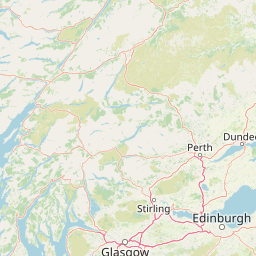
Map view of Loch Creran Marine Protected Area

Use this park location map to pinpoint Loch Creran Marine Protected Area in United Kingdom, understand its exact geographic position, and read its mapped placement within the surrounding landscape more clearly.

Pigeon | © OpenStreetMap contributors

Location context for Loch Creran Marine Protected Area

Argyll and ButeScotland
Recorded earthquake history

Examine the Loch Creran Historical Earthquake Records and Seismic Data Collection

Review the complete historical catalogue of recorded seismic events identified near the boundaries of Loch Creran. This archive organizes data by magnitude and distance to provide an objective look at the seismic background of this Scottish marine landscape.

Loch Creran Earthquake History

Catalogued events

8 events

Strongest magnitude

Magnitude 4.2

Most recent event

Apr 16, 2026

This history includes earthquakes recorded inside the park or within 50 km of its borders

Explore photographic records of marine protected areas, tidal narrows, and ancient Atlantic oakwoods.

Loch Creran Photos and Landscape Scenery: Visualizing Scottish Sea Loch Habitats

Photographic collections reveal the complex terrain of deep marine basins and sheltered shorelines across the protected sea loch environment. Visual documentation helps researchers and visitors examine coastal habitats, tidal sills, and native woodlands in rich geographical detail.

A covered sailboat sits in the foreground on a grassy bank at low tide, with the calm water of a sea loch and distant green hills under an overcast sky in the background.

Park atlas

Compare nearby marine reserves and coastal habitats across western Scotland

Explore Parks Near Loch Creran and Surrounding Protected Landscapes

Browse protected areas and coastal reserves situated near Loch Creran to examine wider regional geography. Comparing neighboring conservation landscapes reveals how marine basins and highland terrain connect across the western seaboard.
Marine protected areaScotland
About 14 km away#1 closest

Southwest

Loch Sunart to the Sound of Jura Marine Protected Area: A Scottish Marine Geography Guide

Charting habitat management and Quaternary seabed geology in the western Highlands.

This protected area reaches across the waters of Loch Sunart, the Sound of Mull, the Firth of Lorne, and the Sound of Jura. By mapping this diverse bathymetry, the area safeguards essential marine habitats and the rare common skate population within a complex network of Highland sounds and coastal basins.

Area
741 km²
Established
2014
IUCN
IV
Climate
Temperate
Marine protected areaLochaber
About 27 km away#2 closest

Northwest

Loch Sunart Marine Protected Area: Coastal Geography and Highland Seascape Atlas

Deep-water marine basins and protected Highland coastal terrain.

Discover the mapped landscape of Loch Sunart, a 31-kilometre sea loch in the Lochaber region of Scotland. This marine protected area is characterized by its complex underwater bathymetry, ranging from shallow tidal channels to deep basins reaching 124 metres, providing a unique look into the intersection of terrestrial Highland mountains and essential underwater bivalve and reef communities.

Area
49 km²
Established
2014
IUCN
IV
Relief
Lowland
Watercolor illustration showing mountains, green forests, a loch, and a river in a landscape
National parkScotland
31 km away#3 closest

Southeast

Loch Lomond and The Trossachs National Park: Mapped Landscapes and Terrain

Regional geography and protected Highland boundaries in Scotland

Loch Lomond and The Trossachs National Park covers a vast array of protected habitats, from coastal sea lochs to high-altitude Munros. This geographic profile outlines the park's position across the Highland Boundary Fault, highlighting its role as a core protected area for Caledonian forests and freshwater lake ecosystems within Scotland.

Area
1,865 km²
Established
2002
IUCN
V
Visitors
2.9M annual
Protected landscapeHighland
About 34 km away#4 closest

Northwest

Morar, Moidart and Ardnamurchan National Scenic Area: Coastal Geography and Protected Lands

A mapped overview of peninsulas, lochs, and Highland terrain

Investigate the protected landscape of Morar, Moidart and Ardnamurchan. This area combines dramatic basalt cliffs, silver sands, and significant historical sites within a remote maritime setting. Gain clarity on the overlapping conservation zones and the complex geography that shapes this distinctive Scottish coastal region.

Area
369.6 km²
Established
1981
Relief
Mixed relief
Access
Moderate access
Protected landscapeArgyll and Bute
About 38 km away#5 closest

Southwest

Scarba, Lunga and the Garvellachs National Scenic Area: Protected Island Geography

Coastal landscapes and tidal seascapes of Argyll and Bute

Gain insight into the distinct protected landscape of the Scarba, Lunga and the Garvellachs National Scenic Area. This area balances mountainous moorland with green meadows, while its submerged marine reefs and fierce tidal waters contribute to a complex ecological and geographic identity within the Firth of Lorn.

Area
65 km²
Established
1981
Relief
Upland
Climate
Temperate
A soft, artistic watercolor painting of a Scottish sea loch surrounded by gentle, green hills against a faint mountainous background.
Marine protected areaArgyll and Bute
About 51 km away#6 closest

Southeast

Loch Goil Marine Protected Area: Geography and Landscape Overview

Protected marine habitats in the Argyll and Bute region

Loch Goil offers a distinct look at an enclosed, sea loch landscape in western Scotland. Surrounded by the Arrochar Alps and steep conifer slopes, this marine protected area demonstrates the intersection of Highland wilderness and formal conservation zones. Use this atlas resource to understand its topographical form and regional context.

Established
2014
Relief
Mountain
Climate
Temperate
Access
Moderate access
A soft watercolor illustration depicting green rolling hills and a body of water in a minimalist style.
Marine protected areaArgyll and Bute
About 52 km away#7 closest

South

Loch Fyne Marine Protected Area and Highland Coastal Geography

Mapped sea loch landscapes in Argyll and Bute

Loch Fyne represents a unique intersection of maritime tradition and protected natural terrain. This entry maps the loch as it winds through the Cowal Peninsula, highlighting the contrast between northern mountain hinterlands and southern coastal inlets. Users can examine the extent of its protected waters, the surrounding topography, and its historical significance within the geography of western Scotland.

Established
2014
Relief
Mixed relief
Climate
Temperate
Access
Easy access
Marine protected areaArgyll and Bute
About 62 km away#8 closest

South

Loch Sween Marine Protected Area: Coastal Geography and Regional Atlas Map

A distinctive sea loch ecosystem in Argyll and Bute.

Investigate the coastal topography and protected marine boundaries of Loch Sween. This sea loch is defined by its irregular branching inlets and islands, creating a unique habitat mosaic of maerl beds and burrowed mud within the broader context of the western Scottish coastline.

Area
41 km²
Established
2014
IUCN
IV
Access
Access unknown

Common questions about visiting, size, designation, and location context for Loch Creran Marine Protected Area

Loch Creran Marine Protected Area FAQs for park facts, access, geography, and protected area context

Find quick answers about Loch Creran Marine Protected Area, including protected-area facts, park geography, trail and visitor context, and how the park fits into its surrounding country and regional landscape.
MoriAtlas Explorer

Continue Your Protected Areas Search Across the Global Atlas

Deepen your exploration by continuing the structured search for national parks and protected areas worldwide. Utilize the comprehensive filtering capabilities to compare different conservation landscapes and refine your understanding of global park geography. Discover more about the distribution and characteristics of protected natural areas.

Global natural geography