

Mori Atlas logo
Marine protected areaLoch Sunart

Mapping the dramatic coastal terrain, underwater bathymetry, and protected ecosystems of the Ardnamurchan and Morvern coastline.

Loch Sunart Marine Protected Area: An Atlas of Scotland's Deep Highland Sea Loch Landscapes

(Loch Sunart Marine Protected Area (NCMPA))

Loch Sunart represents a profound intersection of mountainous Highland geography and marine conservation. Extending 31 kilometres into the Lochaber region, this sea loch features diverse underwater basins reaching depths of 124 metres and complex tidal shorelines defined by rocky headlands and islands. The area stands as an internationally significant marine protected landscape, preserving delicate flame shell beds, serpulid worm reefs, and vital seabed habitats across its expansive submerged terrain.

sea lochMarine Protected Areaflame shell bedsbrittlestar habitatserpulid reefsHighland coastline

Loch Sunart

Marine protected area

Park overview

Structured park overview, official facts, and landscape profile for Loch Sunart

Loch Sunart park facts, protected area profile, and essential visitor context

Review the core facts for Loch Sunart, including designation, size, terrain, visitor scale, habitats, and operating context in one park-focused overview.

About Loch Sunart

Loch Sunart is a major sea loch on the western seaboard of Scotland, carving a long saltwater inlet between the Ardnamurchan peninsula to the north and the Morvern peninsula to the south. It lies within the wider Lochaber area of the Highland council region, a landscape defined by ancient volcanic geology, rugged coastlines, and a sparsely populated interior. The loch's sheltered waters, narrow entrances, and varied bottom topography have shaped both its scenery and its ecological character.

The loch stretches roughly 31 kilometres inland from the open Atlantic coast, making it the longest sea loch in the Highland local government area. Its deepest points exceed 120 metres, particularly in basins east of Càrna near the entrance to the smaller Loch Teacuis. Several islands break up the loch's surface, including the inhabited island of Càrna, Oronsay to its seaward side, Risga between the larger land masses, and Eilean Mòr further inland near the lofty slopes of Beinn Resipol.

Although the surrounding shores remain sparsely populated, they are not untouched by human activity. A significant portion of the loch has long been used for aquaculture, with fish farming established in the 1980s and originally focused on salmon before diversifying into other species. Coastal townships such as Strontian and Ardnastang have historical and cultural ties to the loch, and stories of legendary encounters with swans and with the Baobhan Sith, the malevolent fairy figure of Highland folklore, remain part of the local lore.

The defining modern role of Loch Sunart, however, is conservation. The 2014 designation of the entire loch as a Marine Protected Area reflected the high biodiversity value of its seabed, and the subsequent Loch Sunart to the Sound of Jura NCMPA extended that recognition across a far broader piece of Scotland's west coast. Together, these designations positioned Loch Sunart as a key reference site for understanding and protecting marine biodiversity on the Scottish Atlantic seaboard.

Quick facts and research context for Loch Sunart

Loch Sunart lies on the west coast of Scotland within the Lochaber area and the Highland council region. It is a saltwater sea loch that separates the Sunart district of Ardnamurchan from the Morvern peninsula. The loch is approximately 31 kilometres long and reaches a maximum depth of about 124 metres east of the island of Càrna. The whole loch, covering around 4,900 hectares, was designated a Nature Conservation Marine Protected Area in 2014 and is managed by Marine Scotland as a Category IV protected area under the IUCN system.

Protection and recognition

Documented marine protection scope, 2014 designation history, and administrative recognition records

Loch Sunart Protection Status and Designated Marine Area History

Loch Sunart maintains a documented marine protection status established through its 2014 designation history. Official records outline the marine management scope and associated recognition sources for comparative conservation analysis.

Protection details

Protection scope
Marine
Designated year
2014
Transboundary protection
No
Park context

Deeper park guide and search-rich context for Loch Sunart

Loch Sunart history, landscape, wildlife, and travel context

Explore Loch Sunart through its history, landscape character, ecosystems, wildlife, conservation priorities, cultural context, and seasonal travel timing in a structured park guide built for atlas discovery and search intent.

Why Loch Sunart stands out

Loch Sunart is best known for being one of Scotland's most ecologically significant sea lochs, particularly because of its dense flame shell beds and the associated Leptometra celtica populations that depend on them. These fragile bivalve reefs create complex seabed habitats that support serpulid worm communities, sponges, starfish, and brittlestars, turning the muddy basins of the loch into rich underwater environments. The protection of these communities led to the designation of the entire loch as a Marine Protected Area in 2014, and the regional designation that followed placed Loch Sunart at the heart of a much larger conservation zone extending toward the Sound of Jura.
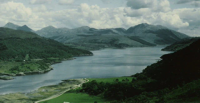
A wide, elevated landscape view of a calm sea loch surrounded by rolling green hills and rugged mountains under a cloudy sky.
A view looking inland over the water of Loch Sunart toward the surrounding mountains.

Loch Sunart history and protected-area timeline

The coastline of Loch Sunart has been inhabited and culturally significant for centuries, with local legend tying the absence of nesting swans on the loch to a tragic tale of a Celtic chieftain whose romantic intentions were thwarted by his mother and ended in death. Folk tradition also surrounds the tidal island of Eilean a' Mhuirich, once associated with the dangerous fairy figure of the Baobhan Sith. The loch has long been part of working coastal Scotland, where fishing, small-scale settlement, and crofting have shaped life along its shores.

A more unusual historical chapter came in 1846 during the Disruption, the split that divided the Church of Scotland. When the local landowner refused to allow the Free Church to construct a place of worship on his land, the minister Graham Speirs arranged for an iron church to be built elsewhere and floated by sea into Loch Sunart. After delays, the prefabricated structure was towed into position in July 1846 and moored about 150 yards offshore in the bay near Ardnastang. It was anchored in time for Sunday worship and flew a large blue flag inscribed with the Gaelic phrase An Eaglais Shaor, meaning the Free Church.

Industrial activity expanded in the twentieth century, particularly from the 1980s onward, when fish farming operations were established in significant portions of the loch. Initially focused on salmon, these aquaculture operations have since diversified. In 2014, after growing scientific recognition of the ecological importance of Loch Sunart's seabed communities, the entire loch was declared a Nature Conservation Marine Protected Area by Marine Scotland. This was later integrated into a much larger regional NCMPA, marking a shift from a working coastal loch to an internationally recognised conservation site.

Loch Sunart landscape and geographic character

Loch Sunart is a long and deeply indented sea loch that penetrates the western Highlands far inland from the open Atlantic. Its shores are framed by the remote, mountainous terrain of Ardnamurchan to the north and the boulder-strewn, lower-lying Morvern peninsula to the south. Beinn Resipol rises prominently above the inland end of the loch, providing a dramatic upland backdrop that contrasts with the sheltered tidal waters below.

The loch's coastline is irregular and varied, with rocky headlands, sheltered bays, and a number of islands that punctuate the navigable channel. Càrna is the most substantial of these islands and supports a small resident community, while smaller land masses such as Oronsay, Risga, and Eilean Mòr add to the loch's broken silhouette. Tidal formations like Eilean a' Mhuirich, connected to Ardnastang beach by the fall of the tide, add further complexity to the shoreline.

Below the surface, the landscape continues through underwater basins and channels, with the deepest recorded point reaching 124 metres east of Càrna near Loch Teacuis. This varied bathymetry creates pockets of soft sediment, rocky reef, and current-swept channels that shape both scenery and ecology. The result is a coastal landscape that reads as both a classic Highland sea loch and a distinctive submerged seascape of considerable natural value.

Loch Sunart ecosystems, habitats, and plant life

The ecology of Loch Sunart reflects the broader character of Scotland's western sea lochs, where saltwater influx from the Atlantic mixes with freshwater runoff from Highland catchments to produce highly productive habitats. Sheltered basins, strong tidal movement, and varied seabed substrates create conditions that support a wide range of marine communities, from filter-feeding invertebrates to predatory fish and seabirds feeding along the shoreline.

The loch's defining ecological feature is its network of fragile seabed habitats, particularly the flame shell beds and the brittlestar populations that depend on them. Dense reefs built by the small bivalve Limaria hians stabilise surrounding sediment and provide structure for other species, including serpulid worm communities that form their own reef-like aggregations. Sponges, starfish, and brittlestars share these habitats, contributing to the biodiversity of the loch floor.

Beyond these protected communities, Loch Sunart sits within a regional seascape of kelp forests, maerl beds, and coastal mudflats, supporting common skate populations and a wide variety of invertebrates on the broader western coast. The combination of restricted water exchange, varied bathymetry, and nutrient inputs from the surrounding Highlands makes the loch a regionally significant ecological zone on Scotland's Atlantic coast.

Loch Sunart wildlife and species highlights

Loch Sunart supports a wide range of marine wildlife shaped by its sheltered sea loch setting. Among the most distinctive residents are the flame shells, small bivalve molluscs whose fragile, nest-like colonies transform stretches of the seabed into dense living reefs. Associated with these flame shell beds is the crinoid Leptometra celtica, a brittlestar-like species whose dense populations are a defining ecological feature of the loch.

The same reefs host serpulid worms, sponges, starfish, and brittlestars, creating a community of invertebrates that thrives in the muddy and mixed substrates of the loch floor. Lobsters and other crustaceans are abundant enough that creeling for them remains permitted within parts of the Marine Protected Area, recognising the longstanding role of shellfish fisheries in the loch.

At a broader scale, Loch Sunart forms part of a coastal ecosystem that includes the common skate, a large and vulnerable elasmobranch whose populations were a key factor in the creation of the larger Loch Sunart to the Sound of Jura NCMPA. Seabirds, marine mammals, and seasonal visitors to the surrounding Highland coast further contribute to the loch's wider wildlife presence, even though the protected features themselves are concentrated below the waterline.

Loch Sunart conservation status and protection priorities

In 2014, the full extent of Loch Sunart, covering roughly 4,900 hectares, was designated a Nature Conservation Marine Protected Area, placing the entire sea loch under a formal Scottish conservation framework aimed at protecting its most sensitive marine features. This designation was driven by the ecological importance of the loch's flame shell beds, the associated Leptometra celtica populations, and the broader diversity of invertebrates that depend on these habitats, including serpulid reefs, sponges, starfish, and brittlestars.

The Loch Sunart MPA is recognised internationally as an IUCN Category IV protected area, a habitat and species management designation that reflects a focus on active conservation of specific ecological features rather than full exclusion of human activity. Within the MPA, the use of fishing gear is generally prohibited, while creeling for crustaceans such as lobsters is permitted in certain parts of the loch, balancing conservation with traditional coastal livelihoods.

The conservation significance of Loch Sunart extends well beyond the loch itself. The waters of Loch Sunart form part of the much larger Loch Sunart to the Sound of Jura NCMPA, which spans approximately 74,100 hectares and extends through the Sound of Mull, the Firth of Lorne, and on toward the Sound of Jura. This broader designation protects populations of common skate, a vulnerable species of major conservation concern in the northeast Atlantic, along with regionally important quaternary geological features. Together, these layered designations make Loch Sunart a cornerstone of marine conservation on Scotland's Atlantic coast.

Loch Sunart cultural meaning and human context

Loch Sunart sits within a region of Scotland where the landscape and local culture remain closely intertwined. Its Gaelic name, Loch Shuaineart, reflects the long-standing linguistic heritage of the western Highlands, while the surrounding districts of Sunart and Morvern maintain cultural traditions linked to crofting, fishing, and Gaelic-speaking communities. Island settlements such as Càrna preserve a sense of the small, dispersed coastal life that has historically defined the area.

Local legend is deeply embedded in the loch's geography. The traditional explanation for the absence of nesting swans on its waters is a tragic love story involving a Celtic chieftain, his mother, and a forbidden romance turned fatal. The tidal island of Eilean a' Mhuirich carries another, darker tale linked to the Baobhan Sith, the fearsome fairy figure of Highland folklore. These stories are not simply decorative, they reflect how the loch has long been imagined as a place of threshold experiences, where land and water, myth and reality, intersect.

The mid-nineteenth century Disruption provided another distinctively local cultural episode. The towing of a floating iron church across the sea and into Loch Sunart in 1846 became a symbol of religious independence in the Highlands. The Gaelic inscription An Eaglais Shaor, meaning the Free Church, displayed on the church as it lay anchored near Ardnastang, marked a moment when Highland communities asserted both spiritual and practical control over access to the loch and its shoreline.

Top sights and standout views in Loch Sunart

Loch Sunart combines dramatic Highland coastal scenery with internationally important marine biodiversity, making it a standout sea loch on Scotland's west coast. Its sheer scale, 31 kilometres long and reaching depths of around 124 metres, anchors a varied seascape of islands, tidal formations, and sheltered bays framed by the mountains of Ardnamurchan and Morvern. The 2014 designation of the entire loch as a Marine Protected Area recognises the exceptional value of its flame shell beds, serpulid reefs, and brittlestar communities, and ties it into one of Scotland's largest regional MPAs protecting common skate and quaternary geology.

Best time to visit Loch Sunart

Loch Sunart can be appreciated throughout much of the year, but the warmer months from late spring through early autumn tend to offer the calmest sea conditions, longer daylight hours, and the most comfortable setting for exploring its shoreline by road or by boat. Late spring and early summer are generally associated with more settled weather along the western Highlands, while autumn brings vivid colour to the surrounding hills and quieter conditions for those seeking a more contemplative visit. Winter visits can be atmospheric, particularly for those drawn to the loch's cultural and literary associations, though weather can be more variable and remote sections of the coastline become less accessible.
Monthly climate preview

Long-term representative point measurements tracking monthly averages across Lochaber

Loch Sunart Climate Normals, Annual Temperature and Precipitation Patterns

Representative coordinate records outline the measured annual temperature rhythm and monthly precipitation totals for Loch Sunart from 1991 to 2020. Examining the complete twelve-month statistical profile provides detailed insight into long-term climate normals across the protected landscape.
Annual mean8 °C
4 °C13 °C
Jan
Feb
Mar
Apr
May
Jun12°
Jul13°
Aug13°
Sep12°
Oct
Nov
Dec
Warmest month
July

13.4 °C

Coolest month
February

3.9 °C

Wettest month
January

6.5 mm/day

Driest month
May

3.3 mm/day

Park location guide

Geography guide, regional context, and park location map for Loch Sunart

Loch Sunart park geography, regions, and map view in United Kingdom

Understand where Loch Sunart sits in United Kingdom through a broader geographic reading of the surrounding landscape, nearby location context, and its mapped position within the national park landscape.

How Loch Sunart fits into United Kingdom

The United Kingdom is a parliamentary constitutional monarchy located in northwestern Europe, consisting of four constituent countries: England, Scotland, Wales, and Northern Ireland. As a major global power with over 69 million residents, it maintains significant international influence in politics, economics, and culture.

Wider geography shaping Loch Sunart in United Kingdom

The United Kingdom is an island nation located in northwestern Europe, surrounded by the Atlantic Ocean, North Sea, English Channel, Celtic Sea, and Irish Sea. It shares a land border with the Republic of Ireland to the west. The territory includes the island of Great Britain, the northeastern portion of Ireland, and most of the smaller British Isles islands.

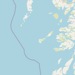
Map view of Loch Sunart

Use this park location map to pinpoint Loch Sunart in United Kingdom, understand its exact geographic position, and read its mapped placement within the surrounding landscape more clearly.

Pigeon | © OpenStreetMap contributors

Location context for Loch Sunart

LochaberScotland

Explore photographic records of coastal terrain, island groups, and marine habitats across Loch Sunart.

Loch Sunart Landscape Photos and Scenery: Visualizing Highland Protected Areas

Visual documentation captures the rugged mountain framing, rocky headlands, and sheltered marine environments defining Loch Sunart. Photographic records reveal the complex coastal terrain and protected marine habitats that characterize this Scottish sea loch.

A wide, elevated landscape view of a calm sea loch surrounded by rolling green hills and rugged mountains under a cloudy sky.

A wide view of a calm sea loch with rocky shoreline in the foreground and rolling hills in the background under a blue sky.

Park atlas

Compare adjacent Highland conservation zones and regional marine habitats

Parks Near Loch Sunart: Explore Other Protected Areas and Coastal Landscapes

Browse other protected areas and coastal reserves situated across the surrounding Highland region after reviewing Loch Sunart. This comparison helps trace connected marine habitats and mountainous terrain throughout the western coast.
Protected landscapeHighland
About 8.9 km away#1 closest

North

Morar, Moidart and Ardnamurchan National Scenic Area: Coastal Geography and Protected Lands

A mapped overview of peninsulas, lochs, and Highland terrain

Investigate the protected landscape of Morar, Moidart and Ardnamurchan. This area combines dramatic basalt cliffs, silver sands, and significant historical sites within a remote maritime setting. Gain clarity on the overlapping conservation zones and the complex geography that shapes this distinctive Scottish coastal region.

Area
369.6 km²
Established
1981
Relief
Mixed relief
Access
Moderate access
Marine protected areaArgyll and Bute
About 27 km away#2 closest

Southeast

Loch Creran Marine Protected Area: Atlas and Coastal Geography of Argyll and Bute

Mapped tidal basins, flame shell reefs, and Atlantic oakwood habitats

Loch Creran is a primary example of integrated marine and coastal conservation on the west coast of Scotland. Characterized by its long, narrow form and dramatic bathymetry, the loch creates a rich environment where rapid tidal currents meet sheltered forest shorelines. This record provides a detailed look at the geographic structure, protected seabed zones, and the transition from sea loch to the ancient woodlands at the head of the inlet.

Area
12 km²
Established
2014
IUCN
IV
Relief
Lowland
Marine protected areaScotland
About 32 km away#3 closest

South

Loch Sunart to the Sound of Jura Marine Protected Area: A Scottish Marine Geography Guide

Charting habitat management and Quaternary seabed geology in the western Highlands.

This protected area reaches across the waters of Loch Sunart, the Sound of Mull, the Firth of Lorne, and the Sound of Jura. By mapping this diverse bathymetry, the area safeguards essential marine habitats and the rare common skate population within a complex network of Highland sounds and coastal basins.

Area
741 km²
Established
2014
IUCN
IV
Climate
Temperate
Watercolor painting of a coastal landscape with distant mountains, a rocky shoreline, and light foreground vegetation on a white background.
Protected landscapeHighland
About 43 km away#4 closest

Northwest

Small Isles Protected Landscape: Atlas of the Highland Inner Hebrides Archipelago

Mapped terrain, volcanic geology, and coastal protected areas.

Delve into the geography of the Small Isles, a protected landscape encompassing Rùm, Eigg, Canna, and Muck. This atlas entry provides a structured look at the volcanic peaks, maritime skerries, and diverse land-stewardship boundaries that define this remote Scottish archipelago.

Area
472.35 km²
Established
1981
Relief
Mountain
Climate
Temperate
Protected landscapeArgyll and Bute
About 54 km away#5 closest

South

Scarba, Lunga and the Garvellachs National Scenic Area: Protected Island Geography

Coastal landscapes and tidal seascapes of Argyll and Bute

Gain insight into the distinct protected landscape of the Scarba, Lunga and the Garvellachs National Scenic Area. This area balances mountainous moorland with green meadows, while its submerged marine reefs and fierce tidal waters contribute to a complex ecological and geographic identity within the Firth of Lorn.

Area
65 km²
Established
1981
Relief
Upland
Climate
Temperate
Marine protected areaHighland
About 64 km away#6 closest

North

Loch Alsh Nature Conservation Marine Protected Area: Geography and Protected Boundaries

A vital Highland marine landscape featuring rare underwater flame shell colonies.

Loch Alsh sits as a distinct marine boundary in the Northwest Highlands of Scotland. This protected area safeguards a vast seafloor ecosystem, most notably a massive flame shell colony that has transformed local understanding of marine biodiversity in the region. The loch landscape blends ancient metamorphic geology with the fjord-like waters separating Skye from the mainland, offering a unique perspective on protected coastal terrains.

Area
0.75 km²
Established
2014
Relief
Mountain
Climate
Temperate
Watercolor illustration showing mountains, green forests, a loch, and a river in a landscape
National parkScotland
About 66 km away#7 closest

Southeast

Loch Lomond and The Trossachs National Park: Mapped Landscapes and Terrain

Regional geography and protected Highland boundaries in Scotland

Loch Lomond and The Trossachs National Park covers a vast array of protected habitats, from coastal sea lochs to high-altitude Munros. This geographic profile outlines the park's position across the Highland Boundary Fault, highlighting its role as a core protected area for Caledonian forests and freshwater lake ecosystems within Scotland.

Area
1,865 km²
Established
2002
IUCN
V
Visitors
2.9M annual
A soft, impressionistic watercolor painting of a Scottish loch surrounded by rolling green hills and distant mountain silhouettes.
Marine protected areaRoss and Cromarty
About 76 km away#8 closest

North

Loch Carron Marine Protected Area: Coastal Geography and Protected Seabed Landscape Atlas

Exploring the tidal basins and underwater terrain of Ross and Cromarty.

Loch Carron stands as a landmark marine protected area defined by its dramatic underwater depth changes and robust tidal currents. This protected sea loch features the world's largest flame shell colony nestled beneath the cliffs at Strome Castle. The surrounding Highland geography of Ross and Cromarty creates a compressed, mountain-framed landscape that influences the rich ecological character of this essential coastal habitat.

Area
23 km²
Established
2019
Relief
Lowland
Climate
Temperate

Common questions about visiting, size, designation, and location context for Loch Sunart

Loch Sunart FAQs for park facts, access, geography, and protected area context

Find quick answers about Loch Sunart, including protected-area facts, park geography, trail and visitor context, and how the park fits into its surrounding country and regional landscape.
MoriAtlas Explorer

Continue Your Protected Areas Search Across the Global Atlas

Deepen your exploration by continuing the structured search for national parks and protected areas worldwide. Utilize the comprehensive filtering capabilities to compare different conservation landscapes and refine your understanding of global park geography. Discover more about the distribution and characteristics of protected natural areas.

Global natural geography

