Mori Atlas logo
Marine protected areaLoch Sween

Understanding the sheltered inlets and coastal features of this Scottish sea loch.

Loch Sween Marine Protected Area: Coastal Geography and Mapped Marine Landscapes in Argyll and Bute

(Loch Sween Marine Protected Area)

Loch Sween is a prominent sea loch located on the western coastline of Argyll and Bute, characterized by a complex network of inlets, islands, and branching basins. This marine protected area serves as a critical site for native oyster populations, maerl beds, and burrowed mud habitats that define its inner sheltered geography. Through detailed mapping and landscape analysis, the region showcases the transition from exposed tidal waters facing the Sound of Jura to the calm, intricate fingers of the inner basins.

sea lochmarine protected areamaerl bedsnative oysterscoastal islandsScottish west coast

Loch Sween

Marine protected area

Park overview

Structured park overview, official facts, and landscape profile for Loch Sween

Loch Sween park facts, protected area profile, and essential visitor context

Review the core facts for Loch Sween, including designation, size, terrain, visitor scale, habitats, and operating context in one park-focused overview.

About Loch Sween

Loch Sween is a long, branching sea loch on Scotland's western seaboard, a drowned valley penetrating the Knapdale and mid-Argyll coastline between the Sound of Jura and the inland hills west of Lochgilphead. Rather than a single simple inlet, the loch opens into a network of secondary basins: the narrow finger of Caol Scotnish reaching north and east, the sheltered anchorage of Loch a' Bhealaich near Tayvallich, the small bridged embayment of Loch Craiglin, the larger inlet leading to the village of Achnamara, and the long inlet of Linne Mhuirich halfway down its length. Together these form a tiered transition from open tidal water at the mouth to protected inner basins with their own islands, narrows, and quiet edges.

The loch's identity as a protected area is rooted in what lies beneath its surface rather than its visible scenery. The inner basins contain maerl beds, loose carbonate structures built by slow-growing red algae that create a habitat for many other marine organisms; neighbouring muds are extensively burrowed by invertebrate life, and one of the inner basins hosts a notable colony of volcano worms. At the more tidal mouth of the loch, the seabed shifts toward coarser sediments shaped by stronger currents. Equally important is one of the most important remaining native oyster populations in Scottish waters, anchored in the loch and now central to its conservation status.

Above the waterline, Loch Sween is framed by low shoreline pasture, forested inlets like Taynish, and a constellation of small islands along both shores, while the hills of the Paps of Jura form a distant backdrop across the open sea to the west. Medieval Castle Sween stands on the southern shore near the more exposed seaward end, giving the loch a long human history alongside its natural environment. The combination of inland inlets, marine habitat diversity, archipelago character, and cultural landmarks has made Loch Sween a recognised focus for marine conservation in Scotland.

Quick facts and research context for Loch Sween

Loch Sween lies on the western coast of Scotland within the council area of Argyll and Bute, branching inland from waters connected to the Sound of Jura. The protected area covers roughly 4,100 hectares and is managed as a Nature Conservation Marine Protected Area under the Scottish Government, with Marine Scotland acting as the responsible authority.

Designated in 2014, Loch Sween is classified as a Category IV protected area by the International Union for Conservation of Nature, a designation reserved for areas managed primarily for the protection of specific habitats and species. Within its waters sit maerl beds, burrowed mud communities, and one of Scotland's most significant populations of native oysters, which together give the site a distinct conservation profile along Scotland's west coast.

Protection and recognition

Documented marine protection scope, 2014 designation history, and recognition data for Loch Sween

Loch Sween Protection Status and Marine Conservation Designation History

Loch Sween holds a documented marine protection scope established in the year 2014. Certified records outline the conservation framework and designation history associated with the protected area.

Protection details

Protection scope
Marine
Designated year
2014
Transboundary protection
No
Park context

Deeper park guide and search-rich context for Loch Sween

Loch Sween history, landscape, wildlife, and travel context

Explore Loch Sween through its history, landscape character, ecosystems, wildlife, conservation priorities, cultural context, and seasonal travel timing in a structured park guide built for atlas discovery and search intent.

Loch Sween history and protected-area timeline

Loch Sween's human history stretches back well beyond the modern protected area, with medieval Castle Sween long anchoring the southern shore near the seaward entrance of the loch. Over centuries the loch has functioned as a sheltered byway along Scotland's western coast, with small ports, fishers, and island communities using its inner inlets and bays. Causeways now link some islands such as Danna to the mainland, physically formalising older crossings that small craft once navigated between sea lochs.

The loch's conservation history is more recent. In 2014, Loch Sween was formally designated by the Scottish Government as a Nature Conservation Marine Protected Area, the marine equivalent of the country's terrestrial protected-area designations. The decision recognised the site's exceptional marine biodiversity, particularly its maerl beds, burrowed mud communities, and native oyster population, and brought its management under Marine Scotland. The International Union for Conservation of Nature subsequently classified Loch Sween as a Category IV protected area, placing it in the international category reserved for areas managed primarily to conserve specific habitats and species. Today, Loch Sween stands as one of a network of marine protected areas along Scotland's west coast, reflecting both contemporary conservation science and the long-standing maritime use of these sheltered waters.

Loch Sween landscape and geographic character

Loch Sween is a long sea loch of irregular outline, entering the land from the south-west and running north-east through a sequence of branching inlets. The outer part of the loch faces west toward the open Sound of Jura and is influenced by stronger tidal movement, while the inner basins become progressively more sheltered. Caol Scotnish, the most northerly finger, pushes further inland than the main body of water, and the smaller Loch a' Bhealaich sits beside it as a quiet anchorage.
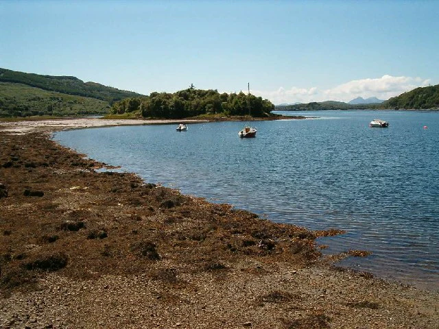
A wide angle view of the shoreline of Loch Sween with the island of Eilean Mhartan in the distance; three small boats are moored in the calm sea loch.
Eilean Mhartan on Loch Sween, featuring small boats moored in the calm water.

Loch Sween ecosystems, habitats, and plant life

The waters of Loch Sween contain some of the most important marine habitats on western Scotland. The inner loch holds maerl beds, slow-growing beds of calcareous red algae that form a delicate three-dimensional habitat, alongside extensive burrowed muds shaped by dense communities of marine invertebrates. One of the inner basins is also home to a colony of volcano worms, a distinctive biological feature that further emphasises the unusual character of the seabed here. Toward the outer mouth, tidal strength increases and the seabed transitions to coarser sediments shaped by faster-moving water.

Loch Sween wildlife and species highlights

Above all, Loch Sween is recognised for marine rather than terrestrial wildlife. In particular it supports one of Scotland's most important populations of native oysters, a species that has declined heavily across much of its former European range and is the focus of major restoration interest. The loch's burrowed mud communities host a rich range of marine invertebrates, while the maerl beds provide habitat for many associated small marine species.

Loch Sween conservation status and protection priorities

Loch Sween's importance to conservation lies in the marine life of its sheltered inner basins and the threats faced by those habitats elsewhere in Europe. Maerl beds grow over very long timescales and are easily damaged by physical disturbance, burrowed muds depend on stable seabed conditions, and native oyster reefs have been heavily reduced across Europe through historic overharvest and habitat loss. Concentrating these features in a single Scottish sea loch gives the site an outsized conservation value relative to its size.

The loch was formally designated as a Nature Conservation Marine Protected Area in 2014, sitting within the Scottish Government's framework of marine protection and managed by Marine Scotland. The designation reflects recognition that active management is required to safeguard the maerl beds, native oyster population, and associated habitats. Internationally, Loch Sween is classified as a Category IV protected area, the IUCN category reserved for sites managed primarily to protect particular species and habitats, rather than for wilderness or broad ecosystem conservation. In this way the protected area operates as a focused safeguard for some of Scotland's most vulnerable marine communities.

Loch Sween cultural meaning and human context

Human presence around Loch Sween has long been shaped by its sheltered waters and defensible coastlines. Castle Sween on the southern shore is one of the oldest stone castles on Scotland's west coast, anchoring the loch's medieval story, while small coastal villages such as Tayvallich and Achnamara reflect a more recent maritime and fishing culture that still uses the loch today. Causeways joining islands like Danna to the mainland show how transport and settlement have been adapted over generations to the loch's geography.

Top sights and standout views in Loch Sween

The defining qualities of Loch Sween sit below the waterline. The loch holds one of Scotland's most important remaining native oyster populations, alongside maerl beds and burrowed mud communities that together represent a distinctive marine habitat mosaic.

Best time to visit Loch Sween

Spring and summer tend to bring the mildest conditions and the longest daylight hours along Scotland's western coast, with clearer views inland to the surrounding hills and across to the distant Paps of Jura and a more active small-craft scene in the inner inlets. Outer weather along this coast remains changeable year-round, and arrival of autumn and winter often brings stronger winds, rougher water at the mouth of the loch, and a quieter, more atmospheric character for visitors interested in the landscape itself.
Monthly climate preview

Long-term representative temperature and precipitation patterns across the coordinate

Loch Sween Climate Normals and Measured Annual Weather by Month

Loch Sween exhibits a measured annual cycle ranging from average winter lows near freezing to moderate summer highs alongside consistent monthly precipitation. Reviewing the complete twelve-month climatology profile clarifies the detailed temperature and precipitation rhythms across the protected area.
Annual mean9 °C
5 °C14 °C
Jan
Feb
Mar
Apr
May10°
Jun12°
Jul14°
Aug14°
Sep12°
Oct10°
Nov
Dec
Warmest month
August

13.9 °C

Coolest month
February

4.8 °C

Wettest month
January

5.4 mm/day

Driest month
May

2.9 mm/day

Park location guide

Geography guide, regional context, and park location map for Loch Sween

Loch Sween park geography, regions, and map view in United Kingdom

Understand where Loch Sween sits in United Kingdom through a broader geographic reading of the surrounding landscape, nearby location context, and its mapped position within the national park landscape.

How Loch Sween fits into United Kingdom

The United Kingdom is a parliamentary constitutional monarchy located in northwestern Europe, consisting of four constituent countries: England, Scotland, Wales, and Northern Ireland. As a major global power with over 69 million residents, it maintains significant international influence in politics, economics, and culture.

Wider geography shaping Loch Sween in United Kingdom

The United Kingdom is an island nation located in northwestern Europe, surrounded by the Atlantic Ocean, North Sea, English Channel, Celtic Sea, and Irish Sea. It shares a land border with the Republic of Ireland to the west. The territory includes the island of Great Britain, the northeastern portion of Ireland, and most of the smaller British Isles islands.

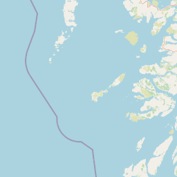
Map view of Loch Sween

Use this park location map to pinpoint Loch Sween in United Kingdom, understand its exact geographic position, and read its mapped placement within the surrounding landscape more clearly.

Pigeon | © OpenStreetMap contributors

Location context for Loch Sween

Argyll and ButeScotland

Explore protected area views, coastal islands, and sheltered inlets across the Argyll and Bute coastline.

Loch Sween Photos and Coastal Scenery: Visualizing Western Scotland Marine Landscapes

Visual documentation reveals the complex coastal terrain and marine habitats that define the Loch Sween protected area. Photographs capture the interplay between sheltered inner basins, offshore islands, and open sea views across the Scottish coast.

A wide landscape view of Loch Sween in Scotland, showing the sea loch, its inlets, and surrounding hills, with a group of three people walking on a grassy trail in the foreground.

A wide angle view of the shoreline of Loch Sween with the island of Eilean Mhartan in the distance; three small boats are moored in the calm sea loch.

Park atlas

Compare adjacent marine reserves and regional landscapes across western Scotland

Explore Other Parks Near Loch Sween and Surrounding Coastal Protected Areas

Browse protected areas and coastal habitats situated near Loch Sween in western Scotland. Evaluating these connected marine landscapes provides a wider geographical perspective on regional conservation areas.
A soft watercolor illustration depicting green rolling hills and a body of water in a minimalist style.
Marine protected areaArgyll and Bute
About 23 km away#1 closest

Northeast

Loch Fyne Marine Protected Area and Highland Coastal Geography

Mapped sea loch landscapes in Argyll and Bute

Loch Fyne represents a unique intersection of maritime tradition and protected natural terrain. This entry maps the loch as it winds through the Cowal Peninsula, highlighting the contrast between northern mountain hinterlands and southern coastal inlets. Users can examine the extent of its protected waters, the surrounding topography, and its historical significance within the geography of western Scotland.

Established
2014
Relief
Mixed relief
Climate
Temperate
Access
Easy access
Protected landscapeArgyll and Bute
About 28 km away#2 closest

North

Scarba, Lunga and the Garvellachs National Scenic Area: Protected Island Geography

Coastal landscapes and tidal seascapes of Argyll and Bute

Gain insight into the distinct protected landscape of the Scarba, Lunga and the Garvellachs National Scenic Area. This area balances mountainous moorland with green meadows, while its submerged marine reefs and fierce tidal waters contribute to a complex ecological and geographic identity within the Firth of Lorn.

Area
65 km²
Established
1981
Relief
Upland
Climate
Temperate
Watercolor illustration showing mountains, green forests, a loch, and a river in a landscape
National parkScotland
About 35 km away#3 closest

Northeast

Loch Lomond and The Trossachs National Park: Mapped Landscapes and Terrain

Regional geography and protected Highland boundaries in Scotland

Loch Lomond and The Trossachs National Park covers a vast array of protected habitats, from coastal sea lochs to high-altitude Munros. This geographic profile outlines the park's position across the Highland Boundary Fault, highlighting its role as a core protected area for Caledonian forests and freshwater lake ecosystems within Scotland.

Area
1,865 km²
Established
2002
IUCN
V
Visitors
2.9M annual
A soft, artistic watercolor painting of a Scottish sea loch surrounded by gentle, green hills against a faint mountainous background.
Marine protected areaArgyll and Bute
About 51 km away#4 closest

East

Loch Goil Marine Protected Area: Geography and Landscape Overview

Protected marine habitats in the Argyll and Bute region

Loch Goil offers a distinct look at an enclosed, sea loch landscape in western Scotland. Surrounded by the Arrochar Alps and steep conifer slopes, this marine protected area demonstrates the intersection of Highland wilderness and formal conservation zones. Use this atlas resource to understand its topographical form and regional context.

Established
2014
Relief
Mountain
Climate
Temperate
Access
Moderate access
Marine protected areaScotland
About 52 km away#5 closest

North

Loch Sunart to the Sound of Jura Marine Protected Area: A Scottish Marine Geography Guide

Charting habitat management and Quaternary seabed geology in the western Highlands.

This protected area reaches across the waters of Loch Sunart, the Sound of Mull, the Firth of Lorne, and the Sound of Jura. By mapping this diverse bathymetry, the area safeguards essential marine habitats and the rare common skate population within a complex network of Highland sounds and coastal basins.

Area
741 km²
Established
2014
IUCN
IV
Climate
Temperate
A soft watercolor illustration featuring green rolling hills; pink foliage; and a calm bay under a pale sky.
Marine protected areaScotland
About 58 km away#6 closest

Southeast

Lamlash Marine Protected Area: Coastal Geography and Protected Waters in Scotland

Maritime terrain and conservation landscapes of the Firth of Clyde

Located along the eastern coast of the Isle of Arran, the Lamlash Marine Protected Area serves as a landmark for community-led conservation in Scotland. The site protects a vital marine ecosystem including maerl beds within a sheltered natural harbour, providing a distinct study of coastal boundaries and marine terrain facing Holy Isle across the Firth of Clyde.

Established
2008
Visitors
1.1K annual
Relief
Lowland
Climate
Temperate
Marine protected areaArgyll and Bute
About 62 km away#7 closest

North

Loch Creran Marine Protected Area: Atlas and Coastal Geography of Argyll and Bute

Mapped tidal basins, flame shell reefs, and Atlantic oakwood habitats

Loch Creran is a primary example of integrated marine and coastal conservation on the west coast of Scotland. Characterized by its long, narrow form and dramatic bathymetry, the loch creates a rich environment where rapid tidal currents meet sheltered forest shorelines. This record provides a detailed look at the geographic structure, protected seabed zones, and the transition from sea loch to the ancient woodlands at the head of the inlet.

Area
12 km²
Established
2014
IUCN
IV
Relief
Lowland
A soft watercolor painting of a landscape featuring green rolling hills, a suggestion of a reflective body of water, and layers of purple distant mountains against a light sky.
National parkScotland
About 67 km away#8 closest

East

Loch Lomond and The Trossachs National Park: Geographic and Protected Area Overview

Tracing Highland and Lowland transition zones in Scotland

This protected area captures the contrast between the rugged mountainous terrain of the northern Trossachs and the gentler southern loch basins. By examining the Highland Boundary Fault, users can analyze how glaciers carved the landscape, creating the deep fjord-like trenches and islands that define the region's unique natural geography.

Area
71 km²
Established
2002
Relief
Mountain
Climate
Temperate

Common questions about visiting, size, designation, and location context for Loch Sween

Loch Sween FAQs for park facts, access, geography, and protected area context

Find quick answers about Loch Sween, including protected-area facts, park geography, trail and visitor context, and how the park fits into its surrounding country and regional landscape.
MoriAtlas Explorer

Continue Your Protected Areas Search Across the Global Atlas

Deepen your exploration by continuing the structured search for national parks and protected areas worldwide. Utilize the comprehensive filtering capabilities to compare different conservation landscapes and refine your understanding of global park geography. Discover more about the distribution and characteristics of protected natural areas.

Global natural geography