
Mori Atlas logo
Nature reserveLochwiesen von Biblis

A critical conservation landscape preserving rare lowland meadow habitats in the Hessisches Ried region.

Lochwiesen von Biblis Nature Reserve: Mapping the Protected Rhine Valley Floodplain Meadows

(Naturschutzgebiet Lochwiesen von Biblis)

Lochwiesen von Biblis represents a vital fragment of the historic Rhine floodplain in southern Hesse. This protected nature reserve shelters rare Stromtalwiesen and reed beds that have largely vanished from the surrounding Upper Rhine lowlands. By examining the local map and terrain, observers can identify how this site sustains meadow biodiversity and pollarded willow stands against the industrial backdrop of the central German landscape.

nature reservefloodplain meadowsStromtalwiesenNiederungswiesenreed bedspollarded willows
A flat-style graphic illustration showing a sunlit landscape with tall green grasses, cattails in the foreground, scattered trees, and distant hills under a pastel blue sky.

Lochwiesen von Biblis

Nature reserve

Park overview

Structured park overview, official facts, and landscape profile for Lochwiesen von Biblis

Lochwiesen von Biblis park facts, protected area profile, and essential visitor context

Review the core facts for Lochwiesen von Biblis, including designation, size, terrain, visitor scale, habitats, and operating context in one park-focused overview.

About Lochwiesen von Biblis

Lochwiesen von Biblis is one of many statutory nature reserves in the Bergstraße district of Hesse, but its ecological character differs sharply from the forested valley reserves further east in the Odenwald. Set within the flat, fertile terrain of the Hessisches Ried, just inland from the Rhine, it preserves open meadow and wetland habitats that belong to the historical floodplain mosaic of the Upper Rhine valley. The reserve has been protected since 1992 and is part of the wider Geo-Naturpark Bergstraße-Odenwald, as well as the contiguous EU Bird Protection Area that stretches along the Rhine between Biblis and Groß-Rohrheim.

The site's importance lies in the unusually rich although narrow ecological profile that it retains. It contains Stromtalwiesen, a distinctive type of floodplain meadow associated with lowland river corridors, alongside Niederungswiesen and stands of reeds. Management efforts concentrate on extensive grassland use, the conversion of former arable fields back into meadowland, and the gradual transformation of a small poplar wood into diverse native forest with understory shrubs. Pollarded willows, a traditional rural element of floodplain landscapes, are being actively expanded.

Although the area is bounded by agricultural fields and lies close to a major nuclear power station, it functions as an island of traditional floodplain meadow ecology in a heavily transformed landscape. Connected ecologically to neighboring reserves such as Steiner Wald von Nordheim to the northwest and Hammer Aue von Gernsheim und Groß-Rohrheim to the north, Lochwiesen von Biblis contributes to a longer corridor of protected habitats along the Hessian Rhine bank. The mix of meadowland, reed bed, and woodland patches gives the reserve a multi-layered ecological structure unusual for such a small protected site in the Upper Rhine lowlands.

Quick facts and research context for Lochwiesen von Biblis

Lochwiesen von Biblis is a nature reserve in the Landkreis Bergstraße in the German state of Hesse, within the broader terrestrial planning unit of the Hessisches Ried. It lies in the natural region of the Northern Upper Rhine Lowland, close to the Rhine and about one and a half kilometers from the riverbank. The reserve covers roughly 51 hectares, was officially designated on 25 May 1992, and holds the office identifier 1431021 as well as the World Database on Protected Areas record 164496. It is also part of the EU Bird Protection Area "Rheinaue bei Biblis und Groß-Rohrheim" and falls within the Geo-Naturpark Bergstraße-Odenwald.

Protection and recognition

Explore recorded conservation frameworks and official designation details

Documented Protection Status and Recognition Data for Lochwiesen von Biblis

Lochwiesen von Biblis maintains documented protection status records detailing administrative scope and international recognition. Official registry data provides structured insight into conservation frameworks and governing designations.

Protection details

WDPA ID
164496
Park context

Deeper park guide and search-rich context for Lochwiesen von Biblis

Lochwiesen von Biblis history, landscape, wildlife, and travel context

Explore Lochwiesen von Biblis through its history, landscape character, ecosystems, wildlife, conservation priorities, cultural context, and seasonal travel timing in a structured park guide built for atlas discovery and search intent.

Why Lochwiesen von Biblis stands out

Lochwiesen von Biblis is best known as a surviving piece of the old Rhine floodplain meadow landscape of the Upper Rhine lowlands, with a particular focus on Stromtalwiesen, lowland meadows, and reed beds. Its profile is shaped less by spectacular features than by its ecological rarity: it is a small refuge for habitat types that have largely been replaced by intensive agriculture across the surrounding flatlands of the Hessisches Ried. The combination of extensive grassland management, expanding pollarded willow stands, and the conversion of a small poplar wood into structurally diverse native woodland adds to its conservation identity.
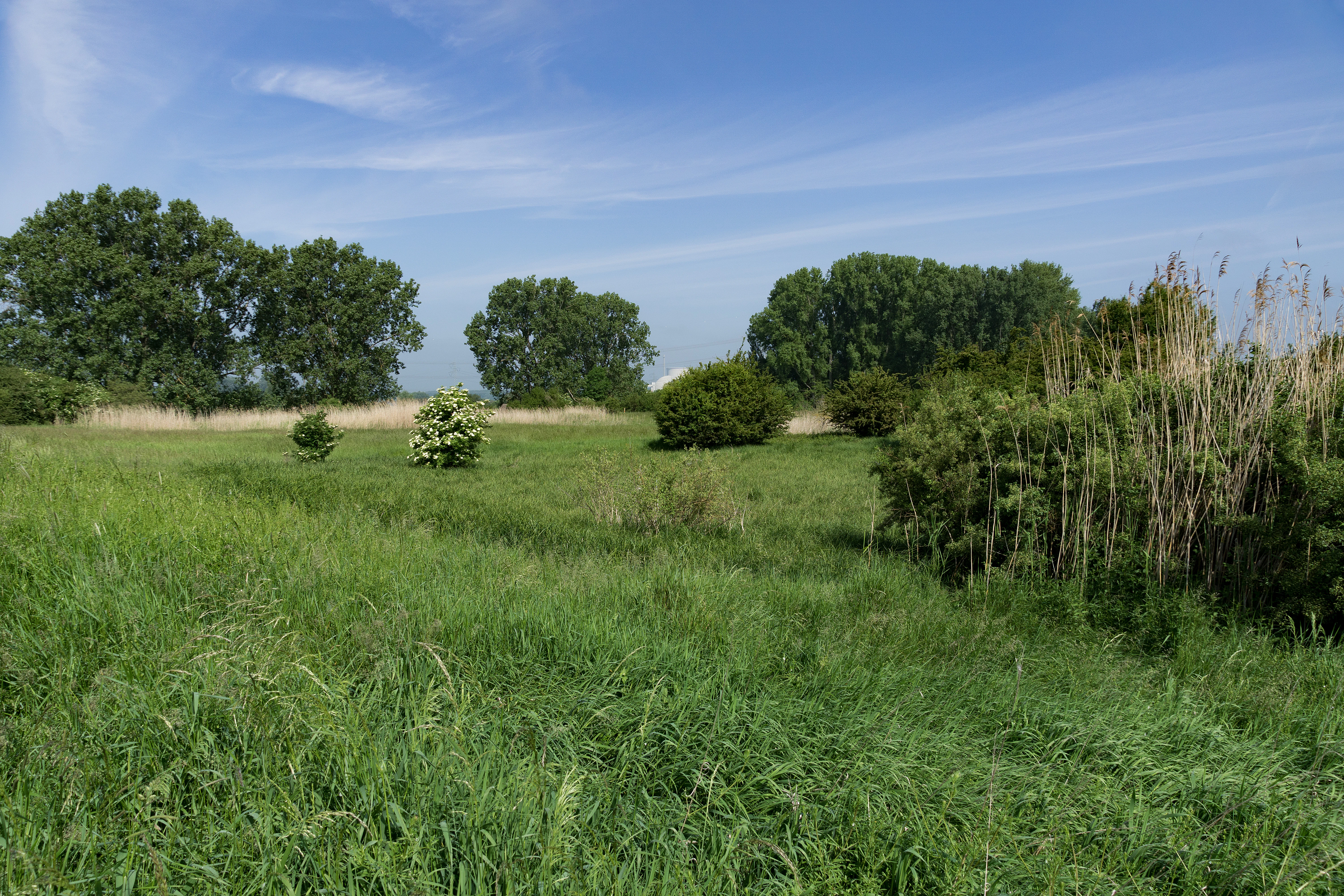
A wide, eye-level shot of a green, grassy floodplain meadow with scattered trees and dense patches of reeds under a blue, slightly hazy sky.
A view of the floodplain meadows and reed beds in the Lochwiesen von Biblis nature reserve.

Lochwiesen von Biblis history and protected-area timeline

The meadows that make up Lochwiesen von Biblis are a surviving fragment of a much larger landscape that has since been lost. At the beginning of the twentieth century, an extensive belt of seasonally wet meadowland stretched several hundred meters wide through the old Rhine floodplain from Wattenheim in the south to Groß-Rohrheim in the north. Through much of the twentieth century, this corridor was progressively converted into more productive agricultural land, drainage was expanded, and much of the original meadow character disappeared.

A formal conservation step came on 25 May 1992, when the Hessian regional authority designated the remaining area of roughly 50 hectares as a statutory nature reserve under the identifier 1431021. The designation was intended to anchor the protection of Stromtalwiesen and Niederungswiesen in the Hessisches Ried, a landscape where these habitat types had become increasingly rare. Since then, conservation management has focused on restoring traditional grassland use, gradually returning arable land to meadow, and actively shaping the woodland and willow components toward more diverse native vegetation. The reserve also became part of the EU Bird Protection Area Rheinaue bei Biblis und Groß-Rohrheim, which linked its protection to broader Rhine floodplain conservation in the region.

Lochwiesen von Biblis landscape and geographic character

The reserve lies in the flat lowland landscape of the Northern Upper Rhine valley, also known as the Hessisches Ried. Its surface is shaped by former Rhine flood dynamics rather than by hills or valleys: the terrain is essentially level, with subtle transitions between meadow, reed, and small wooded patches. The relatively rectangular area is crossed lengthwise by the Mersweg, an established field path that gives the protected area its internal structure.

To the east, the protected area is bordered by the town of Biblis; to the east further still stands the now-decommissioned Biblis Nuclear Power Plant, which forms an unusual backdrop of industrial infrastructure against the otherwise agricultural setting. Northwest and north of the Lochwiesen, additional protected areas line the Rhine bank, including the Steiner Wald von Nordheim and the Hammer Aue von Gernsheim und Groß-Rohrheim. The Rhine itself flows only about one and a half kilometers from the western edge of the reserve, and although the river is not directly within the protection area, its ecological influence on the meadows and reed beds is central to their origin and survival.

Lochwiesen von Biblis ecosystems, habitats, and plant life

Lochwiesen von Biblis represents one of the few functioning examples of traditional Oberrheinische Altauen vegetation left in the Hessian stretch of the Rhine valley. Its core ecosystems are Stromtalwiesen, or floodplain meadows shaped by the influence of large lowland rivers; Niederungswiesen, which are similar low-lying meadows with fluctuating moisture; and reed beds, or Schilfflächen, that develop where soil moisture remains consistent enough for tall emergent vegetation.

A small poplar stand within the protected area adds a further habitat layer, and is deliberately being converted into structurally diverse woodland dominated by native tree and shrub species rather than the original non-native poplars. Pollarded willows in the meadows provide traditional ecological structures, since old pollarded willows host cavities and specialized bark habitats that rarely develop on younger trees. The reserve's ecological profile is intentionally built around extensification, providing a refuge from heavily fertilized agricultural use that dominates the surrounding landscape.

Lochwiesen von Biblis wildlife and species highlights

Because the reserve forms part of the EU Bird Protection Area Rheinaue bei Biblis und Groß-Rohrheim, its wildlife profile is closely tied to the floodplain bird community of the Upper Rhine. Meadow, reed, and willow habitats together provide breeding and resting areas for species typical of large river lowlands, including wet-meadow and reed-bed specialists that have lost much of their former range in southern Hesse.

Traditional pollarded willows and standing deadwood contribute to insect diversity, which in turn supports the food base for insectivorous birds and bats across the wider Rhine floodplain corridor. However, the available source material on the reserve's specific species composition is limited, and much of the site's wildlife significance lies in its habitat function rather than in any single charismatic species. The reserve is therefore best understood ecologically as a key node in a larger connected floodplain fauna network that extends along the Hessian Rhine bank.

Lochwiesen von Biblis conservation status and protection priorities

Within the broader landscape of the Hessisches Ried, Lochwiesen von Biblis occupies a critical conservation niche because the floodplain meadow habitats it protects have largely disappeared from the surrounding area. Its designation under IUCN management category IV indicates that the site is being actively managed to maintain particular species or habitats rather than being left to natural processes alone. Conservation management centers on extensive grassland use, which preserves the herbaceous vegetation typical of Stromtalwiesen and Niederungswiesen without the nutrient enrichment that would push the meadows toward more ordinary agricultural grassland.

Active restoration has several strands. Former arable land within the protected area is being returned to meadowland, the small poplar stand is being rebuilt with native tree species to enhance structural diversity, and the existing pollarded willow population is being expanded. Through its inclusion in the EU Bird Protection Area Rheinaue bei Biblis und Groß-Rohrheim, the reserve also contributes directly to the conservation of birds listed under the Birds Directive for the Hesse portion of the Rhine. Together with neighboring reserves such as Steiner Wald von Nordheim and Hammer Aue von Gernsheim und Groß-Rohrheim, it forms part of a chain of protection sites that maintain floodplain function along what is otherwise a heavily utilized part of the Rhine lowland.

Lochwiesen von Biblis cultural meaning and human context

The landscape surrounding Lochwiesen von Biblis has been shaped by generations of rural land use in the Rheintal, where traditional meadows and pollarded willows once formed part of the working agricultural landscape. Although most of this cultural context has been lost to modern arable farming across the wider Ried, the reserve preserves several elements of that older land-use tradition. Pollarded willows in particular are a feature of historical floodplain meadows, where they provided brushwood, fodder, and basket-making material while also creating distinctive microhabitats within the meadows.

The renaming of the meadow belt and its visible industrial neighbor, the now-decommissioned Biblis Nuclear Power Plant, give the site a sharply modern local frame in which a small remnant of traditional meadows sits next to one of the defining infrastructure elements of southern Hesse. The reserve can therefore be understood both as an ecological refuge and as a place where the older rural heritage of the Hessian Rhine lowlands is partially kept alive through ongoing management.

Top sights and standout views in Lochwiesen von Biblis

Of the many nature reserves in the Landkreis Bergstraße, Lochwiesen von Biblis stands out for its position in the flat Rhine lowlands rather than in the Odenwald hills. It protects a rare surviving mosaic of Stromtalwiesen, Niederungswiesen, and reed beds, and is one of the key components of the contiguous EU Bird Protection Area along the Hessian Rhine between Biblis and Groß-Rohrheim. Its combination of meadow restoration, pollarded willow conservation, and conversion of poplar wood to native woodland illustrates a carefully layered approach to preserving the functional character of Upper Rhine floodplain habitats in a very small area.

Best time to visit Lochwiesen von Biblis

As a flat lowland meadow landscape, Lochwiesen von Biblis has its strongest ecological character from late spring through summer, when wet meadows reach full bloom and reed beds are at their tallest. Late spring is generally a useful period to observe flowering vegetation in the Stromtalwiesen and Niederungswiesen, while summer offers the highest vegetation cover and is the most relevant time for observing reed-bed and meadow insects and associated birdlife within the broader EU Bird Protection Area. Autumn and winter visits have a quieter, more skeletal look dominated by reed remains, bare pollarded willows, and open meadowland.
Monthly climate preview

Long-term representative coordinate records of average temperature and precipitation rhythm

Lochwiesen von Biblis Climate Normals and Measured Annual Weather Patterns

Historical monitoring across a representative coordinate tracks average monthly temperatures ranging from near freezing to warm summer peaks alongside steady precipitation rates. Reviewing full twelve-month climatology records reveals the complete statistical baseline for temperature and moisture distribution.
Annual mean10 °C
0 °C20 °C
Jan
Feb
Mar
Apr
May14°
Jun18°
Jul20°
Aug20°
Sep15°
Oct10°
Nov
Dec
Warmest month
July

20.4 °C

Coolest month
January

0.3 °C

Wettest month
July

2.2 mm/day

Driest month
April

1.4 mm/day

Park location guide

Geography guide, regional context, and park location map for Lochwiesen von Biblis

Lochwiesen von Biblis park geography, regions, and map view in Germany

Understand where Lochwiesen von Biblis sits in Germany through a broader geographic reading of the surrounding landscape, nearby location context, and its mapped position within the national park landscape.

How Lochwiesen von Biblis fits into Germany

Germany is a federal republic in Western and Central Europe with a population of over 83 million across sixteen constituent states. It is Europe's largest economy by nominal GDP and a major global exporter and importer. The capital is Berlin, and the country borders Denmark, Poland, Czech Republic, Austria, Switzerland, France, Luxembourg, Belgium, and the Netherlands.

Wider geography shaping Lochwiesen von Biblis in Germany

Germany is located in Western and Central Europe, spanning 357,022 km². It borders Denmark to the north, Poland and the Czech Republic to the east, Austria and Switzerland to the south, and France, Luxembourg, Belgium, and the Netherlands to the west. The country has coastlines on the Baltic Sea and North Sea to the north, with the Alps located in the southern region.

Map view of Lochwiesen von Biblis

Use this park location map to pinpoint Lochwiesen von Biblis in Germany, understand its exact geographic position, and read its mapped placement within the surrounding landscape more clearly.

Pigeon | © OpenStreetMap contributors

Location context for Lochwiesen von Biblis

Hesse

Visualizing the floodplain meadows and wetland habitats of the Upper Rhine lowlands

Lochwiesen von Biblis Photos and Landscape Scenery

Visual documentation captures the level terrain, seasonal reed beds, and pollarded willows characteristic of this protected Rhine floodplain refuge. Examining these field photographs reveals the ecological structure and habitat mosaic that define the protected landscape of southern Hesse.

A wide, eye-level shot of a green, grassy floodplain meadow with scattered trees and dense patches of reeds under a blue, slightly hazy sky.

Park atlas

Compare adjacent floodplain reserves and surrounding regional ecosystems

Parks Near Lochwiesen von Biblis and Related Protected Landscapes

Visitors exploring Lochwiesen von Biblis can examine other protected areas and wetland reserves situated along the Upper Rhine lowlands. Broadening the geographic scope reveals connected conservation networks and similar floodplain habitats across the surrounding region.
A horizontal watercolor painting showing a soft, light-filled wetland scene with grassy banks, two small trees, and a calm waterway under a bright, hazy sky.
Nature reserveRhineland-Palatinate
About 5.8 km away#1 closest

Northwest

Naturschutzgebiet Der Spieß An der Spießbrücke Nature Reserve and Wetland Atlas Geography

Protected floodplain habitat in the Rhineland-Palatinate region

This nature reserve protects a vital 9-hectare wetland mosaic near Worms, Germany, featuring an old Rhine arm known as the Altrhein. The site functions as a key resting area for rare bird species, characterized by its reedbeds, wet meadows, and ongoing integration into larger regional floodplain restoration initiatives throughout the Upper Rhine basin.

Area
0.093 km²
Established
1985
Relief
Lowland
Scope
Terrestrial
A soft watercolor painting of a winding river flowing through a lush green floodplain with distant hills under a pale sky.
Nature reserveHessen
About 8.7 km away#2 closest

North

Kühkopf-Knoblochsaue Nature Reserve: A Detailed Look at Hessian Rhine Floodplain Geography

Protected river island terrain, alluvial forests, and floodplain dynamics

Examine the geographic characteristics of Kühkopf-Knoblochsaue, the premier nature reserve in the Hessian Ried. This site provides an in-depth atlas perspective on the Rhine floodplain, featuring the iconic inland island structure, softwood and hardwood forest transitions, and the ongoing influence of the Stockstadt-Erfelder Altrhein on the local terrain.

Area
24.4 km²
Established
1952
Relief
Lowland
Climate
Temperate
A soft watercolor painting showing a winding river through a green landscape with soft, rolling hills in the background under a pale sky.
Nature reserveHessen
About 10 km away#3 closest

South

Naturschutzgebiet Lampertheimer Altrhein: Mapped Wetland Nature Reserve in Hessen Germany

Historic Rhine meander and protected bird sanctuary landscape

The Naturschutzgebiet Lampertheimer Altrhein stands as a landmark of floodplain conservation in Hessen, protecting a large-scale former Rhine meander. This reserve integrates shallow oxbow lakes, extensive wet grasslands, and riparian forest into a coherent mosaic of habitats, offering a detailed glimpse into the ecological evolution of the Upper Rhine valley.

Area
5.156 km²
Established
1937
IUCN
IV
Relief
Lowland
Nature reserveRhineland-Palatinate
About 11 km away#4 closest

South

Wormser Ried Nature Reserve: Mapped Landscape and Protected Area Context

A wetland mosaic in the Rhineland-Palatinate floodplain

Situated in the southern periphery of Worms, the Wormser Ried is a compact, embanked nature reserve defined by its history as an industrial settling area. The site represents a distinct, internally managed wetland system comprising ponds, reed belts, and softwood alluvial forest fragments that support regional biodiversity within an otherwise developed landscape.

Area
0.353 km²
Established
1968
Relief
Lowland
Climate
Temperate
A soft-focus watercolor painting of a wetland scene showing a calm body of water with reeds in the foreground and a tree-lined horizon under a pastel sky.
Nature reserveHessen
About 12 km away#5 closest

East

Erlache bei Bensheim: Exploring Protected Wetlands and Altneckar Landscapes in Hessen

A distinct nature reserve and bird sanctuary site

The Erlache bei Bensheim nature reserve serves as a critical wetland corridor in the Hessian Rhine plain. This area features a former loop of the River Neckar, now characterized by alder swamp forest, reedbeds, and open water, creating a highly specific ecological terrain surrounded by the regional infrastructure of the Bergstraße district.

Area
0.49 km²
Established
2000
IUCN
IV
Relief
Lowland
A soft, delicate watercolor painting depicting a meandering river flowing through a lush, grassy wetland landscape with rolling hills in the background.
Nature reserveHessen
About 12 km away#6 closest

Northeast

Altneckarlachen von Alsbach, Hähnlein und Bickenbach: Protected Wetland and River Geography

A rare mosaic of prehistoric river loops in the Hessian Rhine plain

Altneckarlachen von Alsbach, Hähnlein und Bickenbach protects a unique sequence of prehistoric Neckar meanders featuring shallow water zones, reed belts, and black-alder swamp forest. This nature reserve in the Darmstadt-Dieburg district remains a critical wetland sanctuary, preserving a vital ecological cross-section of the ancient Rhine-Neckar landscape and its associated peatland soils.

Area
0.892 km²
Established
1990
IUCN
IV
Relief
Lowland
A watercolor painting showing a soft, stylized landscape of green meadows, sparse trees, and distant rolling hills against a white background.
Nature reserveHesse
About 12 km away#7 closest

Northeast

Im Dulbaum bei Alsbach Nature Reserve: Mapped Inland Dunes and Grassland Geography

A vital protected sandy terrain in the Hessian Rhine Plain

Im Dulbaum bei Alsbach protects a remnant of the historic Rhine graben sand dune belt in southern Hesse. This nature reserve provides essential habitat connectivity for heat-loving species through its distinct calcareous sand grasslands and former quarry terrain, offering a look into the region's complex ecological history.

Area
0.092 km²
Established
1994
IUCN
IV
Relief
Lowland
A soft watercolor painting of a rolling green hillside with trees, set against a pale, light-colored background.
Nature reserveHessen
About 14 km away#8 closest

East

Orbishöhe von Auerbach und Zwingenberg: Geography, Landscape, and Protected Area Mapping

An examination of Hessian quarry-based ecological conservation sites.

The Orbishöhe von Auerbach und Zwingenberg nature reserve serves as a prime example of localized conservation within the Odenwald hills. Its landscape is defined by former quarry faces and open slope terraces, which provide a critical habitat for rare and threatened plant species. This resource offers a clear look at the reserve's topography, physical boundaries, and its broader role within the Natura 2000 network of protected German lands.

Area
0.064 km²
Established
1988

Common questions about visiting, size, designation, and location context for Lochwiesen von Biblis

Lochwiesen von Biblis FAQs for park facts, access, geography, and protected area context

Find quick answers about Lochwiesen von Biblis, including protected-area facts, park geography, trail and visitor context, and how the park fits into its surrounding country and regional landscape.
MoriAtlas Explorer

Continue Your Protected Areas Search Across the Global Atlas

Deepen your exploration by continuing the structured search for national parks and protected areas worldwide. Utilize the comprehensive filtering capabilities to compare different conservation landscapes and refine your understanding of global park geography. Discover more about the distribution and characteristics of protected natural areas.

Global natural geography