
Mori Atlas logo
Regional parkParque Regional Lomas de Arena

Mapping the distinctive savanna and wetland geography of this protected region near Santa Cruz

Parque Regional Lomas de Arena: An Atlas of Inland Dunes and Transitional Chaco Forest Landscapes

(Parque Departamental y Área Natural de Manejo Integrado Lomas de Arena)

Parque Regional Lomas de Arena protects 14,000 hectares of diverse terrain in the Santa Cruz department, featuring iconic inland dunes that rise 12 meters above the surrounding landscape. This protected area serves as a critical buffer zone, blending transitional Chaco forest, open savanna, and a central lagoon system. Researchers and visitors study this environment to understand the interplay between shifting sandy ridges and the stabilizing vegetation that defines the eastern Bolivian lowlands.

inland dunessand dunesChaco foresttransitional ChacosavannaBolivian lowlands
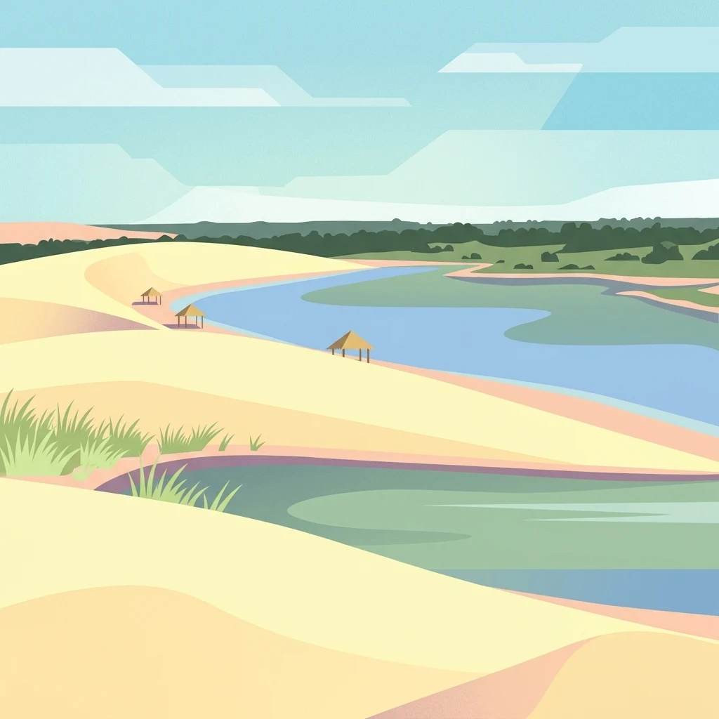
A flat-style digital illustration depicting a desert landscape with large sand dunes, a calm lagoon, and small thatched-roof shelters along the shore, with a forest visible in the background.

Parque Regional Lomas de Arena

Regional park

Park overview

Structured park overview, official facts, and landscape profile for Lomas de Arena Regional Park

Lomas de Arena Regional Park park facts, protected area profile, and essential visitor context

Review the core facts for Lomas de Arena Regional Park, including designation, size, terrain, visitor scale, habitats, and operating context in one park-focused overview.

About Lomas de Arena Regional Park

Lomas de Arena Regional Park protects one of the most unusual natural landscapes in lowland Bolivia: a system of inland sand dunes set within a matrix of transitional Chaco forest, savanna, and seasonal wetlands. Although the area lies just 12 kilometers from the bustling city of Santa Cruz de la Sierra, it preserves an environment that feels far removed from urban Bolivia, with quiet dune sweeps, open grasslands, wooded patches, and a central lagoon system.

The park is managed as a departmental protected area and falls under IUCN Category V, recognizing its value as a working cultural landscape where conservation, recreation, and traditional land use meet. The protected zone is divided among municipal jurisdictions, with the great majority within La Guardia, smaller portions in Santa Cruz de la Sierra and Cabezas. The dune landscape is the dominant visual feature, while the surrounding vegetation stabilizes the sands and supports a rich mixture of wildlife typical of the Chaco-Bolivian transition zone.

Beyond its ecology, the park carries cultural and historical weight. It contains an archaeological site associated with the Chané people and has long served as a weekend escape for residents of Santa Cruz. The combination of accessibility, unusual scenery, and biodiversity makes it a signature destination for understanding the natural heritage of eastern Bolivia, even though it is far smaller than the country's flagship parks like Amboró or Noel Kempff Mercado.

Quick facts and research context for Lomas de Arena Regional Park

Lomas de Arena is a departmental protected area, administered by the Dirección de Áreas Protegidas of the Gobernación de Santa Cruz and classified under IUCN Category V for protected landscapes. It is located about 12 kilometers southeast of Santa Cruz de la Sierra in the Province of Andrés Ibáñez, mostly within the municipality of La Guardia.

The park spans around 14,076 hectares and combines sand dunes reaching up to about 12 meters in height with savanna, transitional Chaco forest, and a principal lagoon. Roughly 286 bird species have been recorded, alongside a range of mammals, reptiles, and plants of regional significance. Establishment traces to 7 September 1990, formalized under Supreme Decree N° 22911 of 25 September 1991.

Protection and recognition

Terrestrial protected area records and establishment chronology from 1991

Parque Regional Lomas de Arena Protection Status and Designation History

Established in 1991, Parque Regional Lomas de Arena maintains a designated terrestrial protection status within its regional landscape. Structured administrative records outline the foundational establishment year and management scope associated with this protected area.

Protection details

Protection scope
Terrestrial
Designated year
1991
Transboundary protection
No
Park context

Deeper park guide and search-rich context for Lomas de Arena Regional Park

Lomas de Arena Regional Park history, landscape, wildlife, and travel context

Explore Lomas de Arena Regional Park through its history, landscape character, ecosystems, wildlife, conservation priorities, cultural context, and seasonal travel timing in a structured park guide built for atlas discovery and search intent.

Why Lomas de Arena Regional Park stands out

The park is best known for its inland dunes rising roughly 12 meters above a mosaic of savanna and forest. These dunes form the park's visual and ecological signature, drawing visitors for their beach-like character despite being far from any coast. Equally important is the mix of transitional Chaco forest and natural savanna that stabilizes and surrounds the dune system. The combination of dunes, a main lagoon, and adjacent woodland gives the park a distinctive landscape that contrasts sharply with the agricultural lowlands around Santa Cruz de la Sierra.
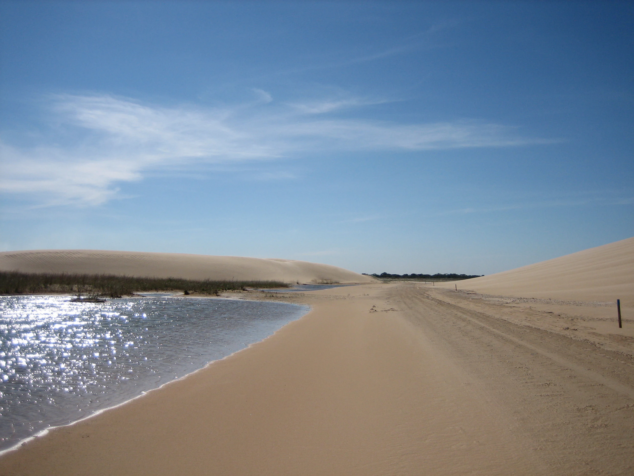
A wide view of light-colored sand dunes meeting a shallow lagoon under a bright blue sky with thin clouds.
The distinctive sand dunes and a reflective lagoon at Lomas de Arena Regional Park.

Lomas de Arena Regional Park history and protected-area timeline

The origins of Lomas de Arena trace to a youth-led conservation campaign in the late 1980s. The Unión Juvenil Cruceñista launched what contemporary press called a 'Crusade for Lomas de Arena,' advocating for the protection of the area's dune ecosystem, its Chané archaeological remains, and the agricultural lands of nearby Mennonite communities.

In response, the Unidad Técnica Desconcentrada del Centro de Desarrollo Forestal de Santa Cruz issued a founding resolution on 6 June 1989, with the park formally created on 7 September 1990. An inter-institutional governing board was established, including the forestry authority, the Comité Pro Santa Cruz, the Universidad Autónoma Gabriel René Moreno, and the Instituto Geográfico Militar.

The board then pursued formal national recognition, resulting in Supreme Decree N° 22911 of 25 September 1991, which cemented the park's protected status. About a decade after creation, administration passed to the Prefectura del Departamento, now the Gobierno Autónomo Departamental de Santa Cruz, which partnered for a five-year period with the Fundación Simón Iturri Patiño before returning full management to the departmental government under the supervision of an inter-institutional management committee.

Lomas de Arena Regional Park landscape and geographic character

The defining landscape feature of Lomas de Arena is a field of inland sand dunes that can reach approximately 12 meters in height. These dunes are not coastal, but are anchored within a continental lowland setting, making them a rare and visually dramatic feature of eastern Bolivia.

Around and between the dunes, the terrain shifts into natural savanna and patches of transitional Chaco forest, with a principal lagoon system anchoring the wetland component of the park. The vegetation acts as a stabilizer for the sands, binding the dunes and shaping the constantly shifting pattern of open sand, grassland, and woodland.

This combination creates a landscape of strong contrasts: bright sandy ridges next to dense green forest patches, open savanna stretching toward wooded edges, and still water reflecting the dune silhouettes. The resulting scenery is what gives the park its beach-like character despite being set in the Bolivian lowlands.
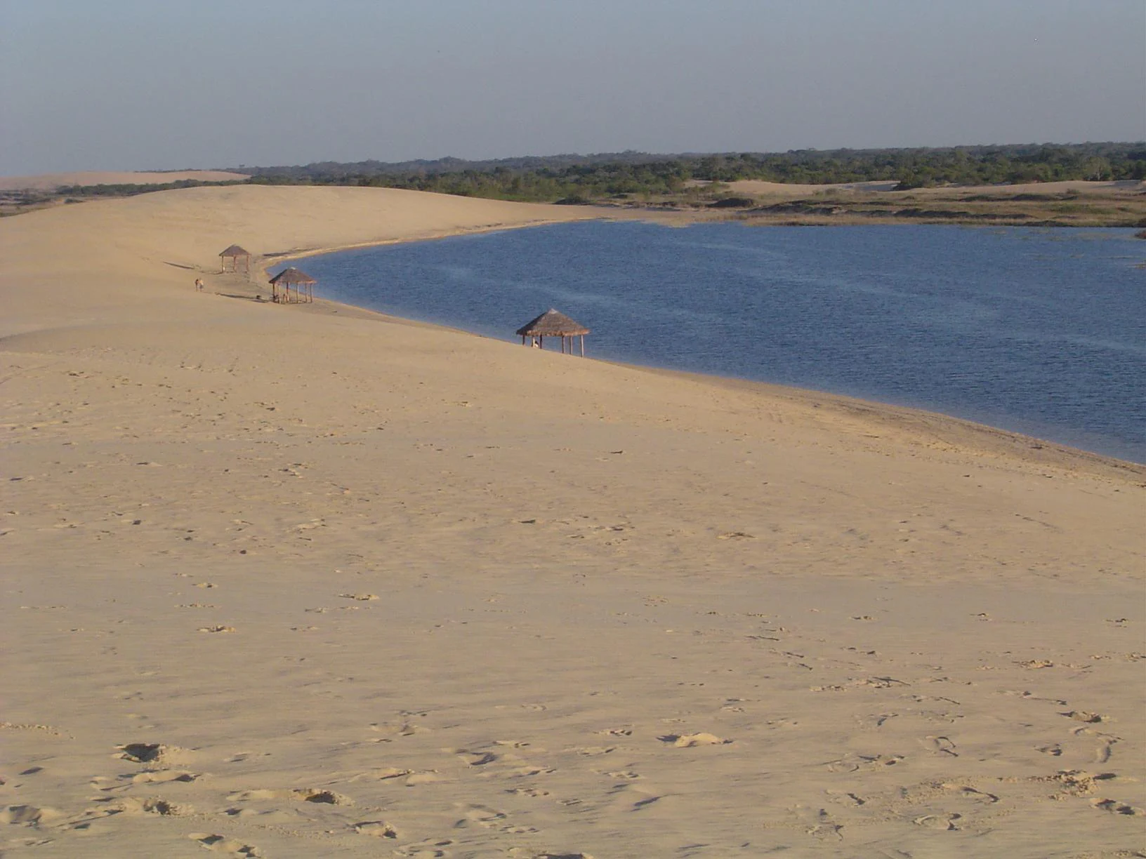
A wide angle view of expansive light tan sand dunes meeting a blue lagoon with several thatched-roof shelters along the shoreline.
Sand dunes and a lagoon at Parque Regional Lomas de Arena.

Lomas de Arena Regional Park ecosystems, habitats, and plant life

Ecologically, Lomas de Arena sits at an important transition zone between the Chaco and the lowland savannas and forests of eastern Bolivia. The site protects representative samples of bosque húmedo transicional chaqueño, or transitional humid Chaco forest, alongside natural savannas that are increasingly rare in the surrounding agricultural landscape.

The vegetation mosaic serves multiple ecological roles. Forest patches stabilize the dune system by anchoring sand, while savanna areas support open-ground species and grazing dynamics. The main lagoon and associated wetlands add an aquatic dimension that supports amphibians, reptiles, and waterbirds, linking the terrestrial habitats into a more cohesive ecosystem.

The protected botanical inventory includes around 208 species of vascular plants. Notable species include the toborochi (Chorisia), tajibo, curupaú (Anadenanthera colubrina), motacú, totaí, and various cactus species adapted to the sandy soils and drier patches within the dune system.

Lomas de Arena Regional Park wildlife and species highlights

The park's mosaic of forest, savanna, dunes, and wetland supports a notable variety of fauna. A special highlight is the presence of the Pichiciego Mayor, or greater fairy armadillo (Calyptophractus retusus), a rare small armadillo adapted to sandy habitats and one of the more distinctive species associated with the park.

Mammal diversity is broad for an area of this size. Recorded species include opossums, anteaters, sloths, at least 12 species of bats, monkeys such as the martín, as well as meleros, tejones, foxes, jochis, urinas, and taitetú. The reptile and amphibian fauna is also significant, with around 50 reptile species, including roughly 27 amphibian species documented within the park.

The birdlife is a major draw and one of the most important biodiversity indicators for the site. Roughly 286 bird species have been recorded, representing about 21 percent of all birds reported for Bolivia. Notable species include the pava campanilla (Pipile cumanensis), the paraba roja or scarlet macaw (Ara macao), and the bato (Bartramia longicauda).

Lomas de Arena Regional Park conservation status and protection priorities

Lomas de Arena is significant for conservation because it safeguards a fragile dune-forest ecosystem embedded in a heavily modified agricultural matrix. Studies in the park, including work referenced from 1997 onward, have classified its forest condition as vulnerable, highlighting the importance of continued protection for the soils, vegetation cover, and biodiversity of the area.

The forest stands are central to the park's ecological functioning: they stabilize dune movement, provide habitat and food for wildlife, preserve scenic value, and prevent desertification that could spread into surrounding productive lands. Yet the protected area is composed entirely of private properties with established agricultural and livestock traditions, which complicates enforcement and makes incremental deforestation a persistent risk alongside fire and land conversion.

The park's IUCN Category V status frames conservation as compatible with traditional land use and recreation rather than as strict exclusion. Through its departmental management, inter-institutional oversight, partnership history with the Fundación Simón Iturri Patiño, and recent interpretive center, the site represents an important example of lowland Bolivia attempting to maintain ecosystem services, cultural heritage, and rural livelihoods within a single protected framework.

Lomas de Arena Regional Park cultural meaning and human context

The park carries cultural meaning on several levels. It contains the only formally identified archaeological site of the Chané culture within the protected landscape, located in a sector known as Los Chivatos, where ceramics and cemetery remains have been recovered.

In modern regional life, Lomas de Arena functions as a major weekend and family recreational landscape for residents of Santa Cruz de la Sierra and nearby La Guardia. Activities such as carriage rides along an approximately five-kilometer ecological trail, horseback excursions, and visits to private rural quintas (recreational farms) tie the park to long-standing traditions of countryside leisure in the lowlands.

The conservation campaign of the late 1980s, launched by the Unión Juvenil Cruceñista and backed by civic groups and the Universidad Autónoma Gabriel René Moreno, also reflects a regional identity built around protecting local natural landmarks as part of Cruceño cultural heritage.

Top sights and standout views in Lomas de Arena Regional Park

Lomas de Arena stands out for the unusual pairing of an inland dune field with stabilizing Chaco forest and savanna, producing a beach-like landscape deep in the Bolivian lowlands. The presence of the rare greater fairy armadillo and the unusually high regional bird diversity add strong nature-watching value.

The site's combination of Chané archaeological heritage, traditional rural quintas, ecological trail experiences, and a recently inaugurated interpretation center gives it layered appeal for visitors interested in ecology, history, and regional culture at once.

Best time to visit Lomas de Arena Regional Park

The park enjoys a tropical lowland climate tied to the wet and dry seasons of the Santa Cruz region. The dry months, roughly coinciding with the southern winter, typically offer the most reliable access, clearer skies for dune scenery, and easier conditions for trails, carriage rides, and beach-style recreation on the sands.

The wet season brings more greenery and bird activity, including migrant species, but also turns tracks to mud and can make the dune and rural access roads more challenging. Visitors oriented toward photography, dune trekking, and family beach days generally favor the dry months, while bird-focused visits can benefit from the wetter period when waterbirds and seasonal migrants are active.
Monthly climate preview

Long-term temperature and precipitation patterns across representative coordinates

Parque Regional Lomas de Arena Climate Normals and Monthly Weather Records

Historical averages for Parque Regional Lomas de Arena document sustained annual temperature rhythms and monthly precipitation variations from representative coordinate data spanning 1991 to 2020. Examining the complete twelve-month profile reveals detailed long-term thermal thresholds and rainfall distributions across the protected area.
Annual mean24 °C
21 °C27 °C
Jan26°
Feb26°
Mar25°
Apr24°
May22°
Jun21°
Jul21°
Aug23°
Sep25°
Oct27°
Nov27°
Dec26°
Warmest month
October

27 °C

Coolest month
July

20.6 °C

Wettest month
January

5.4 mm/day

Driest month
July

1.2 mm/day

Park location guide

Geography guide, regional context, and park location map for Lomas de Arena Regional Park

Lomas de Arena Regional Park park geography, regions, and map view in Bolivia

Understand where Lomas de Arena Regional Park sits in Bolivia through a broader geographic reading of the surrounding landscape, nearby location context, and its mapped position within the national park landscape.

How Lomas de Arena Regional Park fits into Bolivia

Bolivia, officially the Plurinational State of Bolivia, is a landlocked country in central South America. It features diverse geography including the Andean mountain range, Amazonian plains, Gran Chaco, and the Pantanal wetland. The country has a population of approximately 11.4 million and is administratively divided into nine departments, with La Paz as the seat of government and Sucre as the constitutional capital.

Wider geography shaping Lomas de Arena Regional Park in Bolivia

Bolivia is located in central South America, bordered by Brazil to the north and east, Paraguay to the southeast, Argentina to the south, Chile to the southwest, and Peru to the west. The country is divided between a western Andean region and tropical lowlands to the east and north. It includes the Amazonian plain, Gran Chaco, temperate valleys, the high-altitude Altiplano plateau, and part of the Pantanal wetland along its eastern border.

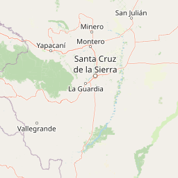
Map view of Lomas de Arena Regional Park

Use this park location map to pinpoint Lomas de Arena Regional Park in Bolivia, understand its exact geographic position, and read its mapped placement within the surrounding landscape more clearly.

Pigeon | © OpenStreetMap contributors

Location context for Lomas de Arena Regional Park

Santa Cruz

Visual reference for the inland sand dunes, savannas, and Chaco forest habitats.

Parque Regional Lomas de Arena Photos: Landscapes, Dunes, and Scenery

Visual documentation captures the dramatic elevation of inland sand dunes and the surrounding transitional Chaco forest habitats. Photographic records illustrate the stark environmental contrast between open sandy ridges and dense lowland vegetation.

A wide view of light-colored sand dunes meeting a shallow lagoon under a bright blue sky with thin clouds.

A greater fairy armadillo with pale, segmented armor and light-colored fur standing on sandy soil in low light.

A wide angle view of expansive light tan sand dunes meeting a blue lagoon with several thatched-roof shelters along the shoreline.

Park atlas

Compare regional landscapes, lowland habitats, and adjacent conservation reserves.

Explore Protected Areas and Parks Near Parque Regional Lomas de Arena

Browse other protected areas and reserves located near Parque Regional Lomas de Arena to examine broader regional geography. Comparing adjacent lowland habitats and surrounding wilderness units provides essential context for regional conservation patterns.
A soft watercolor painting showing a winding river through a valley with trees and palms on the banks and rolling hills in the background.
Nature reserveSanta Cruz
About 25 km away#1 closest

North

Parque de Protección Ecológica del Río Piraí: Protected Geography and Riverine Landscapes

Nature reserve and flood-control corridor in Santa Cruz, Bolivia

This nature reserve encompasses a narrow, sediment-rich corridor following the Río Piraí. It protects representative lowland habitats including Chiquitano dry forest and gallery woodlands, while balancing vital flood-mitigation roles against the pressures of urban expansion. Explore the map of this unique alluvial landscape to understand its ecological significance and role in the regional geography of Santa Cruz.

Area
15.868 km²
Established
1991
Relief
Lowland
Climate
Tropical
Protected areaSanta Cruz
About 35 km away#2 closest

Southeast

Área Protegida Municipal Palmera de Saó: Mapping the Chaco Lowlands and Protected Forest Zones

A vital protected landscape in the Santa Cruz department.

The Área Protegida Municipal Palmera de Saó represents a critical effort to safeguard the saó palm and associated dry forest ecosystems in eastern Bolivia. Stretching along the Río Grande, this protected area features a mosaic of riverine vegetation and alluvial terrain. Understanding its geographic setting reveals how this compact, municipal-level reserve supports both native Chaco wildlife and the cultural crafts of surrounding Guaraní and local communities.

Area
7.58 km²
Established
2006
Relief
Lowland
Scope
Terrestrial
National parkSanta Cruz Department
About 40 km away#3 closest

West

Amboró National Park: Its Protected Area Identity and Geographic Context

Mapped boundaries and regional landscape details.

Amboró National Park is a designated national park situated within the Santa Cruz Department, Bolivia. This entry provides detailed insights into its protected landscape, focusing on its geographical significance and mapped boundaries. Users can explore how Amboró National Park fits into the broader regional geography, enhancing their understanding of conservation areas and mapped natural terrains for atlas-based research and discovery. Its specific location and protected status are crucial for understanding its ecological and geographic role.

Area
4,425 km²
Established
1984
IUCN
II
Relief
Mountain
National parkCochabamba Department
About 129 km away#4 closest

West

Carrasco National Park: National Park Status and Protected Landscape Geography

Explore mapped boundaries within Cochabamba Department.

Carrasco National Park, situated within the Cochabamba Department, represents a critical national park entity. This focus provides users with an atlas-centric view of its protected landscape, detailing its geographic significance and mapped features. Understand the park's terrain and regional context, offering a clear perspective on its conservation value and mapped presence.

Area
6,226 km²
Established
1991
IUCN
II
Relief
Mountain
National parkChuquisaca Department
About 182 km away#5 closest

Southwest

Iñao National Park and Integrated Management Natural Area: Bolivia National Park and Protected Landscape

Explore the Serranía del Iñao's geography and conservation role.

Iñao National Park and Integrated Management Natural Area is a protected territory located within Chuquisaca Department, Bolivia, centered on the prominent Serranía del Iñao mountain range. This page offers detailed geographic context and an atlas perspective on the park's landscape, its role as a national park, and its contribution to regional conservation efforts in the Andean foothills.

Area
2,630.9 km²
Established
2004
IUCN
II
Scope
Terrestrial
Protected areaCochabamba
About 198 km away#6 closest

West

Area Natural Lagarpampa: Protected Inter-Andean Landscapes and Regional Geography

Community-led conservation in the Cochabamba dry valleys.

Spanning over thirty thousand hectares, Area Natural Lagarpampa serves as a significant example of community-driven land protection. The geography features an intricate mix of semi-arid slopes, seasonally active watercourses, and dry-forest ravines that define this part of the Cochabamba highlands. This landscape supports a vital population of the red-fronted macaw, illustrating the intersection between rural agricultural heritage and specialized ecological preservation within the Andean valley system.

Area
303.08 km²
Established
2009
Relief
Upland
Climate
Arid
A horizontal watercolor painting showing a soft mountain landscape with gentle green hills, a small valley, and several palm trees, set against a light, neutral background.
Protected landscapeChuquisaca
About 198 km away#7 closest

West

Área natural de manejo integrado El Palmar: Protected Landscape Geography and Map

Andean mountain ecosystems and endemic palm habitat in Chuquisaca.

Investigate the complex geomorphology of Área natural de manejo integrado El Palmar, a protected area in the Cordillera Oriental of Bolivia. This atlas resource covers the interplay between high-altitude serranías, palm-filled quebradas, and the cultural heritage of the Yampara nation, offering a structured look at its protected boundaries and diverse Andean environment.

Area
594.8 km²
Established
1997
Relief
Mountain
Climate
Mediterranean
Protected landscapeSanta Cruz
About 217 km away#8 closest

Northwest

Área Natural de Manejo Integrado Humedales del Norte Protected Landscape and Wetland Atlas

Mapping the floodplain ecosystems of northern Santa Cruz, Bolivia.

An extensive protected area in northern Santa Cruz that sustains vital Amazonian river systems and seasonal wetland mosaics. This landscape supports complex hydrological functions, including the regulation of climate and regional water cycles, through its vast network of periodically flooded forest tracts and permanent waterways.

Area
4,900.51 km²
Established
2012
Relief
Lowland
Scope
Terrestrial

Common questions about visiting, size, designation, and location context for Lomas de Arena Regional Park

Lomas de Arena Regional Park FAQs for park facts, access, geography, and protected area context

Find quick answers about Lomas de Arena Regional Park, including protected-area facts, park geography, trail and visitor context, and how the park fits into its surrounding country and regional landscape.
MoriAtlas Explorer

Continue Your Protected Areas Search Across the Global Atlas

Deepen your exploration by continuing the structured search for national parks and protected areas worldwide. Utilize the comprehensive filtering capabilities to compare different conservation landscapes and refine your understanding of global park geography. Discover more about the distribution and characteristics of protected natural areas.

Global natural geography