Mori Atlas logo
Wildlife reserveLone Peak Wilderness

Mapping the granite ridgelines, glacial cirques, and protected summits of Utah’s iconic mountain landscape

Lone Peak Wilderness: High Alpine Terrain and Protected Geographic Boundaries in the Wasatch Range

Lone Peak Wilderness stands as a 30,000-acre protected area in the central Wasatch Range, defining the skyline above the Salt Lake and Utah Valleys. This rugged alpine landscape features sharp granite peaks, glacially carved cirques, and narrow canyons that rise abruptly from canyon bottoms to summits exceeding 11,000 feet. As a historic cornerstone of Utah conservation, the area preserves a complex mountain environment ranging from dense coniferous forests to high-elevation rock basins.

wilderness areaalpine terrainWasatch Rangemountain wildernessglacial cirquesgranite peaks

Lone Peak Wilderness

Wildlife reserve

Park overview

Structured park overview, official facts, and landscape profile for Lone Peak Wilderness

Lone Peak Wilderness park facts, protected area profile, and essential visitor context

Review the core facts for Lone Peak Wilderness, including designation, size, terrain, visitor scale, habitats, and operating context in one park-focused overview.

About Lone Peak Wilderness

Lone Peak Wilderness occupies a central position in the Wasatch Range, straddling the boundary between the Salt Lake and Utah Valleys along Utah's populous Wasatch Front. Although it lies within easy reach of major urban areas, including the city of Draper and the broader Salt Lake City metropolitan region, the wilderness preserves a rugged, high-elevation landscape of granite peaks, glacially carved basins, and forested north-facing slopes. Its proximity to densely populated regions gives it an unusual character as a federally protected wilderness that functions almost as a backcountry extension of a major metropolitan region.

Geologically, the area is a varied mix of granitoid rock masses and several sedimentary formations, with much of the present alpine topography shaped by past glaciation. Erosion continues to sculpt the higher terrain, producing exposed rocky ridges, large open cirque basins at the heads of canyons, and a series of small natural and reservoir lakes scattered through the wilderness. Elevations span from roughly 5,500 feet at the lower canyon approaches to more than 11,000 feet at the highest summits, with Lone Peak and the Pfeifferhorn among the most prominent landmarks.

The wilderness is bounded on the north by Little Cottonwood Canyon, on the south by American Fork Canyon, and on the east by the American Fork Twin Peaks, while Timpanogos Cave National Monument lies just beyond its southern edge. This position in the heart of the Wasatch gives the wilderness a pivotal role in the broader protected landscape of the range, tying together high alpine terrain, forested slopes, and the recreational gateway canyons to the west.

At a smaller scale, the wilderness landscape shifts quickly between environments: dense mountain brush and sagebrush steppe on drier slopes; isolated stands of Douglas fir, subalpine fir, and quaking aspen on cooler north-facing hillsides; and open alpine rock, persistent snowfields, and small lakes at the highest elevations. Snow lingers in shaded basins well into mid-summer, reinforcing the sense of a high, seasonal mountain environment despite its proximity to the urban valleys below.

As a whole, Lone Peak Wilderness is not a remote backcountry park in the traditional sense but rather a tightly protected alpine island pressed against one of the fastest-growing urban corridors in the Intermountain West. Its value lies in preserving a compact but dramatic slice of Wasatch scenery, complete with classic Wasatch ridgelines, clear glacial cirques, and dense conifer stands, all within a short distance of major population centers.

Quick facts and research context for Lone Peak Wilderness

Lone Peak Wilderness is a federal wilderness area in Utah and Salt Lake counties, Utah, managed by the U.S. Forest Service across portions of the Uinta and Wasatch-Cache National Forests. It covers about 30,088 acres and was formally established on February 24, 1978 under the Endangered American Wilderness Act.

Its setting in the central Wasatch Range places it immediately above the urban Wasatch Front, and the wilderness serves both as a protected alpine landscape and as a prominent scenic backdrop for nearby communities. Key summits include Lone Peak at 11,253 feet and the Pfeifferhorn at 11,326 feet, while Timpanogos Cave National Monument lies adjacent to its southern boundary.

Protection and recognition

Examine the terrestrial protection scope and documented designation records for this conservation area.

Lone Peak Wilderness Protection Status and International Recognition Facts

Lone Peak Wilderness maintains a defined terrestrial protection scope within its primary conservation boundary. Official records outline the baseline protected area designation and management framework governing the terrain.

Protection details

Protection scope
Terrestrial
Transboundary protection
No
Park context

Deeper park guide and search-rich context for Lone Peak Wilderness

Lone Peak Wilderness history, landscape, wildlife, and travel context

Explore Lone Peak Wilderness through its history, landscape character, ecosystems, wildlife, conservation priorities, cultural context, and seasonal travel timing in a structured park guide built for atlas discovery and search intent.

Why Lone Peak Wilderness stands out

Lone Peak Wilderness is best known for the high, glacially carved alpine terrain of the central Wasatch Range, where sharp granite ridgelines, open cirque basins, and narrow canyons rise directly above the urban Salt Lake and Utah Valleys. The most recognizable landmarks are Lone Peak, the namesake summit of the wilderness, and the Pfeifferhorn, widely nicknamed "Little Matterhorn Peak" for its distinctive pyramidal profile. Equally important to its identity is the contrast between the wilderness and the densely populated Wasatch Front, which makes the area function as a near-urban alpine escape. Trails and summits within the wilderness offer sweeping views across the Salt Lake Valley, Utah Valley, and the surrounding Wasatch peaks, giving the wilderness a strong scenic reputation that extends well beyond its formal boundaries.
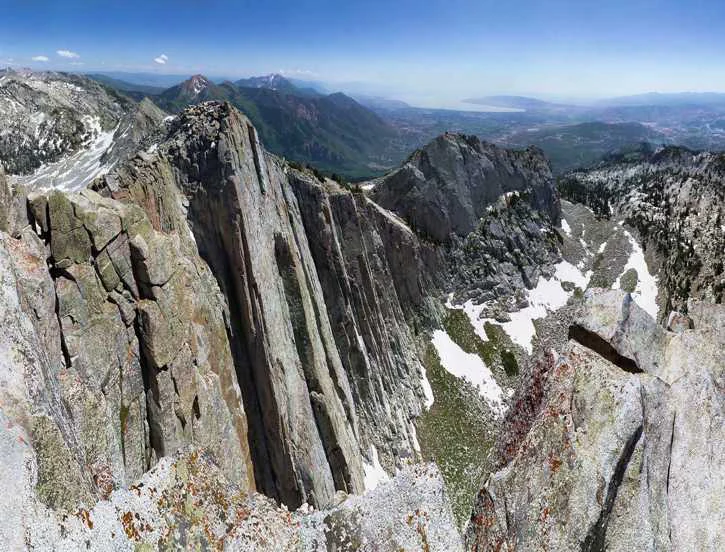
A wide view of a steep, craggy, light-colored granite mountain peak and cliff face with patches of snow remaining in the rocky basins below.
A view looking down from the rugged, granite slopes of Lone Peak in the Wasatch Range.

Lone Peak Wilderness history and protected-area timeline

The Lone Peak Wilderness was formally established on February 24, 1978, as part of the Endangered American Wilderness Act. At the time of its designation, it was the only formally designated wilderness area in the state of Utah, a distinction that would remain until the later enactment of the Utah Wilderness Act of 1984 brought additional Utah lands into the National Wilderness Preservation System.

The wilderness's early protection reflected growing national momentum in the 1970s to safeguard remaining high-quality wild landscapes, including landscapes close to population centers. Its location along the Wasatch Front, where urban growth was already expanding rapidly, gave the designation a particular conservation urgency: protecting a representative block of the central Wasatch Range before further development pressures could fragment it.

Since its establishment, the wilderness has remained under U.S. Forest Service administration within the Uinta and Wasatch-Cache National Forests. Management has emphasized non-motorized recreation and watershed protection, with the wilderness also serving as part of the culinary watershed for Salt Lake County, which has shaped specific restrictions on camping, swimming, and domestic animals within its boundaries.

Lone Peak Wilderness landscape and geographic character

The landscape of Lone Peak Wilderness is defined by the high, rugged core of the central Wasatch Range. The terrain consists of steep alpine ridges, narrow glacial canyons, and prominent summits rising sharply above the surrounding valleys. The two most visually significant peaks are Lone Peak at 11,253 feet and the Pfeifferhorn at 11,326 feet, the latter often compared in profile to Europe's Matterhorn and widely referred to locally as "Little Matterhorn Peak."

Glaciation has played a central role in shaping the present topography. Past ice activity carved the broad, open cirque basins that now characterize the higher elevations and produced the U-shaped profiles of the main canyons. Continued erosion by water, freeze-thaw processes, and rockfall continues to modify these slopes today. Geologically, the foundation of the area is a complex mix of granitoid intrusions and several sedimentary formations, producing the varied rock textures and colors visible across the ridgelines.

At lower elevations, the landscape softens into a patchwork of canyon bottoms, talus slopes, and forested benches, with several small natural lakes and man-made reservoir lakes scattered through the wilderness. Persistent snowfields linger into mid-summer in shaded cirques, and transitions between forested draws and bare alpine rock can occur over short horizontal distances. The result is a compact but visually dramatic high-mountain landscape, notable for the way it rises so abruptly above the deeply urbanized Salt Lake and Utah Valleys just to its west.

Lone Peak Wilderness ecosystems, habitats, and plant life

Ecologically, Lone Peak Wilderness spans multiple vegetation zones that transition rapidly with elevation. Lower and mid-elevation slopes support dense stands of mountain brush mixed with sagebrush and grass, reflecting the drier, sunnier exposures characteristic of the Wasatch Front range. These brushlands give the lower wilderness a semi-arid appearance that gradually shifts into cooler, more forested environments on shaded slopes.

On north-facing slopes and in drainages protected from direct sun, the vegetation changes markedly. Patches of Douglas fir, subalpine fir, and quaking aspen form isolated but distinctive forest stands, providing some of the richest habitat complexity within the wilderness. These cooler pockets contrast sharply with the open sagebrush slopes nearby and contribute to the diversity of plant communities found in the area.

Above the treeline, the environment becomes distinctly alpine, with large open cirque basins, exposed rocky ridges, and small tarns or reservoir lakes. Snow lingers in many of these high basins well into mid-summer, sustaining late-season moisture and shaping the growing conditions for hardy alpine plants. The combination of dry brush slopes, conifer and aspen patches, and high alpine zones gives the wilderness a layered ecological character across a relatively compact area, anchored to the broader ecological patterns of the central Wasatch Range.

Lone Peak Wilderness wildlife and species highlights

Wildlife in the Lone Peak Wilderness reflects the typical species mix of Utah's central Wasatch Range, distributed across brush, forest, and alpine environments. While the available source material does not provide detailed species lists, the mosaic of habitats within the wilderness supports a range of animals associated with sagebrush foothills, mixed conifer forest, and high alpine terrain.

Brushy lower slopes of sagebrush and mountain scrub provide habitat for small mammals and songbirds typical of Great Basin and Intermountain foothill environments, while the scattered Douglas fir, subalpine fir, and aspen stands on north-facing slopes offer cover and forage normally used by middle-elevation forest species. Higher cirques and ridgelines, with their mix of exposed rock, persistent snow, and small lakes, support the more specialized wildlife communities typical of the Wasatch alpine zone.

The wilderness's role as a protected block of habitat adjacent to a major urban corridor makes it an important refuge area, where animals can persist in relatively undisturbed conditions within easy reach of, but largely insulated from, the heavily populated Salt Lake and Utah Valleys.

Lone Peak Wilderness conservation status and protection priorities

Lone Peak Wilderness carries significant conservation value as a protected block of high Wasatch terrain in one of the most rapidly growing urban regions of the Intermountain West. Established under the Endangered American Wilderness Act in 1978, it was the first designated wilderness in Utah and helped anchor the state's entry into the National Wilderness Preservation System.

The wilderness serves several conservation functions simultaneously. It safeguards representative samples of central Wasatch ecosystems, including glacially carved alpine terrain, mixed conifer and aspen forest patches, and sagebrush-dominated slopes, in a setting where unprotected lands face strong development pressure. It also functions as part of the culinary watershed for Salt Lake County, giving the area's protection a direct role in safeguarding downstream water quality.

Management by the U.S. Forest Service emphasizes non-motorized recreation and minimal human impact, with explicit prohibitions on motor vehicles, motorized equipment, hang gliding, bicycles, and open fires in sensitive drainages such as Red Pine Lake, Red Pine Fork, and Maybird Gulch. Group size limits, setback requirements for camping near water, and limits on length of stay at individual sites are all designed to keep the physical wilderness environment intact over time. Together, these protections make the wilderness an important long-term refuge for both ecological values and watershed function along the Wasatch Front.

Lone Peak Wilderness cultural meaning and human context

The Lone Peak Wilderness lies within a region of long-standing human connection to the Wasatch Range, whose canyons, peaks, and alpine basins have historically supported recreation, grazing, watersheds, and resource use tied to nearby communities. Its placement above the Wasatch Front has made it a familiar scenic landmark for the expanding metropolitan populations of the Salt Lake and Utah Valleys, where the high ridgeline of the wilderness functions as a defining visual element of the regional landscape.

Recreational use by hikers, climbers, and hunters has grown alongside the surrounding urban population, embedding the wilderness into the everyday outdoor culture of the Wasatch Front. While the available source material provides limited detail on specific cultural or historical uses, the area's longstanding role as a local mountain backdrop and recreational destination is central to its broader identity within northern Utah.

Top sights and standout views in Lone Peak Wilderness

Lone Peak Wilderness stands out for the compact intensity of its alpine terrain, where glacially carved cirques, sharp granite ridgelines, and small alpine lakes sit directly above two of Utah's major urban valleys. The wilderness's two signature summits, Lone Peak and the Pfeifferhorn ("Little Matterhorn Peak"), anchor a ridgeline experience that has become iconic among Wasatch hikers and scramblers. Equally distinctive is the rapid transition of plant communities, from sagebrush and mountain brush through isolated Douglas fir, subalpine fir, and aspen stands, into open alpine basins still holding snow well into summer.

The combination of formal wilderness protection, watershed importance for Salt Lake County, and management restrictions that limit motorized and heavy-impact uses gives the area a strong conservation identity. Its status as Utah's first designated wilderness, established in 1978, further reinforces its place in the history of American wilderness preservation in the Intermountain West.

Best time to visit Lone Peak Wilderness

Summer and early fall are the primary seasons when the Lone Peak Wilderness is most accessible and most rewarding to experience. From late spring through early autumn, canyon trails are typically snow-free at lower elevations, allowing hikers to reach the higher basins and ridgelines. Summer conditions, however, can be highly variable: daytime temperatures in the higher country can approach the upper 80s or low 90s Fahrenheit, while overnight lows can fall well below 40 degrees Fahrenheit, and occasional afternoon thundershowers are a regular feature of the season. Snow lingers in shaded cirques and on north-facing slopes into mid-summer, shaping both the appearance of the landscape and the timing of access to the most alpine routes.

Late spring offers dramatic snow conditions and running snowmelt streams, while early fall typically brings cooler temperatures, fewer thunderstorms, and the first signs of aspens turning in the higher drainages. Winter brings heavy snow cover and far more limited, avalanche-prone travel, which is reflected in the area's primary use patterns among hikers and scramblers during the warmer months. Across all seasons, visitors should be prepared for rapid weather shifts and significant elevation-driven temperature differences within the wilderness.
Monthly climate preview

Long-term temperature and precipitation records measured at representative park coordinates

Lone Peak Wilderness Climate Normals and Monthly Weather Patterns

Representative coordinate measurements reveal marked annual temperature variations alongside sustained monthly precipitation trends across Lone Peak Wilderness. Detailed monthly climate records provide a comprehensive baseline for analyzing long-term meteorological patterns and regional environmental conditions.
Annual mean9 °C
-4 °C24 °C
Jan-4°
Feb-1°
Mar
Apr
May13°
Jun19°
Jul24°
Aug23°
Sep17°
Oct
Nov
Dec-4°
Warmest month
July

24 °C

Coolest month
January

-3.9 °C

Wettest month
April

2 mm/day

Driest month
July

0.7 mm/day

Park location guide

Geography guide, regional context, and park location map for Lone Peak Wilderness

Lone Peak Wilderness park geography, regions, and map view in United States of America

Understand where Lone Peak Wilderness sits in United States of America through a broader geographic reading of the surrounding landscape, nearby location context, and its mapped position within the national park landscape.

How Lone Peak Wilderness fits into United States of America

The United States of America is a federal presidential republic and one of the world's largest countries by area and population. It consists of 50 states across a vast territory spanning multiple time zones, with its capital in Washington, D.C. and largest city in New York City. The nation has a diverse economy, influential political system, and significant cultural and military presence globally.

Wider geography shaping Lone Peak Wilderness in United States of America

The United States occupies a vast territory in North America, bordered by Canada to the north and Mexico to the south. The 48 contiguous states stretch from the Atlantic to the Pacific Ocean, while Alaska occupies the northwestern region and Hawaii is an archipelago in the Pacific. The country encompasses diverse terrain including the Rocky Mountains, Appalachian Mountains, Great Plains, and extensive river systems.

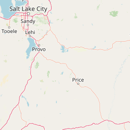
Map view of Lone Peak Wilderness

Use this park location map to pinpoint Lone Peak Wilderness in United States of America, understand its exact geographic position, and read its mapped placement within the surrounding landscape more clearly.

Pigeon | © OpenStreetMap contributors

Location context for Lone Peak Wilderness

Utah
Natural feature types

Explore the Topographic and Natural Features of the Lone Peak Wilderness

View a structured index of named geographic landforms and physical features associated with the Lone Peak Wilderness. Use this collection to map the diverse terrain and glacial landscapes that define this protected section of the central Wasatch Range, supported by the MoriAtlas geographic database.
Recorded earthquake history

Examine Recorded Earthquake History Near Lone Peak Wilderness

Browse the comprehensive collection of seismic events recorded in the vicinity of the Lone Peak Wilderness. This data allows for detailed review of historical activity and epicentre distances within the MoriAtlas framework, focusing on factual documentation rather than future hazard predictions or environmental causality.

Lone Peak Wilderness Earthquake Records

Catalogued events

61 events

Strongest magnitude

Magnitude 5.7

Most recent event

Feb 14, 2026

This history includes earthquakes recorded inside the park or within 50 km of its borders

Visual reference of rugged granite ridgelines, glacial cirques, and high Wasatch terrain

Lone Peak Wilderness Photos, Scenery, and Alpine Landscapes

Visual documentation captures the high alpine terrain, sharp granite ridgelines, and glacial cirques defining Lone Peak Wilderness. Photographic records reveal the dramatic visual contrast between protected mountain ecosystems and the urban valleys below.

A wide view of a steep, craggy, light-colored granite mountain peak and cliff face with patches of snow remaining in the rocky basins below.

Park atlas

Compare adjacent Wasatch Range wilderness areas and connected regional protected lands.

Explore Parks Near Lone Peak Wilderness and Surrounding Protected Mountain Landscapes

Browsing other parks near Lone Peak Wilderness reveals the wider ecological context of the central Wasatch Range and surrounding alpine terrain. Comparing these adjacent protected landscapes provides deeper insight into regional mountain geography and conservation corridors.
A soft watercolor illustration depicting layered green hills in the foreground with faint mountain outlines in the background against a white background.
Wildlife reserveUtah
2.1 km away#1 closest

South

Mount Timpanogos Wilderness: Mapping the Protected Alpine Landscape and High Wasatch Terrain

An iconic Utah protected area within the northern Wasatch Range.

Mount Timpanogos Wilderness preserves a dramatic segment of the Wasatch Range, centering on an iconic summit that rises above glacial basins and forested slopes. This protected area offers a distinct study of alpine geology, featuring high-altitude cirques, steep ridges, and the prominent presence of Emerald Lake. As a critical piece of Utah wilderness, it anchors the skyline above the urban corridor, providing a concentrated look at regional mountain ecosystems and rugged natural terrain.

Area
42.56 km²
Established
1984
IUCN
Ib
Relief
Mountain
A pale watercolor painting showing a wide, panoramic view of layered mountains with light green and muted red hills in the foreground and clusters of pine trees.
Wildlife reserveUtah
About 9.5 km away#2 closest

Northwest

Mount Olympus Wilderness: Geographic Overview of the Iconic Wasatch Range Protected Landscape

Steep granite massif and alpine terrain in northern Utah

Explore the distinct topography of Mount Olympus Wilderness, a protected sanctuary in Utah featuring soaring granite outcrops and deep drainage systems. The park is anchored by a recognizable twin-peak silhouette that rises abruptly from the Salt Lake Valley, encompassing high alpine ridges and one of the deepest known cave systems in the United States within its rugged forested boundaries.

Access
Easy access
A watercolor painting showing a panoramic view of rolling green mountains with a winding stream through a forested valley.
Protected landscapeUtah
56 km away#3 closest

South

Manti, La Sal National Forest: Geographic Overview of Utah's Mountain and Canyon Landscapes

Mapped protected forest boundaries across the Colorado Plateau

Spanning over one million acres, Manti, La Sal National Forest defines a critical segment of Utah geography. This protected landscape encompasses diverse terrain including subalpine mountains, aspen-rich uplands, and deep canyon networks. Use this atlas to examine the distinct environmental characteristics that separate the northern forested plateaus from the southern wilderness canyons.

Area
5,143.09 km²
Established
1950
IUCN
V
Visitors
900K annual
Watercolor painting of a soft landscape featuring distant mountains, rolling hills with light vegetation, and a winding stream in the foreground.
Wildlife reserveUtah
About 68 km away#4 closest

South

Mount Nebo Wilderness: Protected Alpine Ridges and Canyons of the Southern Wasatch Range

Exploring the high-elevation terrain and geological diversity of central Utah

Mount Nebo Wilderness offers a detailed look at the southern terminus of the Wasatch Range, featuring high-altitude summits, subalpine forested corridors, and the iconic badland formations of the Devil's Kitchen. This protected area provides a critical geographic anchor for the region, overlooking Utah Valley and connecting to the wider desert landscapes of the Great Basin through a series of rugged mountain canyons and high-elevation ridgelines.

Relief
Mountain
Climate
Alpine
Access
Moderate access
Scope
Terrestrial
Protected landscapeUnited States of America
About 121 km away#5 closest

North

Wasatch-Cache National Forest Protected Area: Geography, Mountains, and Wilderness Mapping

Analyzing high-mountain terrain and watershed connectivity across the Intermountain West

Wasatch-Cache National Forest serves as a major ecological anchor in the United States. Its territory encompasses the iconic Wasatch Range, extensive designated wilderness zones, and alpine basins. The region provides critical watershed protection and supports diverse high-altitude ecosystems, from narrow, dissected ridges to broad, glaciated terrain throughout northern Utah and surrounding areas.

Area
6,504.01 km²
Established
1906
Relief
Mountain
Access
Easy access
Wildlife reserveUtah
131 km away#6 closest

North

Mount Naomi Wilderness: Mapping High-Altitude Protected Landscapes in Northern Utah

Alpine summits, forested ridges, and subalpine lake basins

Situated in the Bear River Range of northern Utah, Mount Naomi Wilderness stands as a protected corridor of rugged mountain terrain. This wilderness area preserves a diverse high-elevation environment, spanning from the steep western canyons of the Logan River to the prominent summits of Naomi Peak. It serves as a vital point of geographic interest for understanding the subalpine ecosystems and wilderness boundaries within the Uinta-Wasatch-Cache National Forest.

Area
180.18 km²
Established
1984
IUCN
Ib
Relief
Mountain
A watercolor painting showing a stylized landscape with a light blue lake, soft green rolling hills, and hints of red rock cliffs against a white background.
Protected areaWyoming
168 km away#7 closest

East

Flaming Gorge National Recreation Area: Protected Reservoir and Canyon Landscape Atlas

High desert geography and canyon terrain on the Wyoming and Utah border.

Flaming Gorge National Recreation Area features a complex geography where the Green River carves through vivid red sandstone cliffs. This protected area integrates large-scale reservoir management with mountain forest slopes and diverse river corridors, creating a unique mapped landscape that reflects the geologic character of the intermountain West.

Area
839.17 km²
Established
1968
Relief
Upland
Climate
Arid
Protected areaIdaho
179 km away#8 closest

Northwest

Curlew National Grassland: Protected Area Geography and Sagebrush Steppe Landscape in Idaho

Mapped regional geography and rangeland conservation context

Located in southeastern Idaho, Curlew National Grassland offers an expansive view of the Intermountain sagebrush steppe. This protected area provides a historical example of Depression-era land restoration and currently functions as a vital habitat for sagebrush-associated wildlife, showcasing the unique, rolling plains and semi-arid terrain characteristic of the northern Great Basin.

Area
193.4 km²
Established
1934
Relief
Upland
Scope
Terrestrial

Common questions about visiting, size, designation, and location context for Lone Peak Wilderness

Lone Peak Wilderness FAQs for park facts, access, geography, and protected area context

Find quick answers about Lone Peak Wilderness, including protected-area facts, park geography, trail and visitor context, and how the park fits into its surrounding country and regional landscape.
MoriAtlas Explorer

Continue Your Protected Areas Search Across the Global Atlas

Deepen your exploration by continuing the structured search for national parks and protected areas worldwide. Utilize the comprehensive filtering capabilities to compare different conservation landscapes and refine your understanding of global park geography. Discover more about the distribution and characteristics of protected natural areas.

Global natural geography