Mori Atlas logo
National parkLos Nevados National Natural Park

Mapping the protected boundaries and natural terrain of this Colombian national park.

Los Nevados National Natural Park: Colombia's Protected Landscape Geography

(Parque Nacional Natural Los Nevados)

Los Nevados National Natural Park represents a significant protected landscape within Colombia's diverse geography. This national park detail page focuses on its specific mapped boundaries, regional setting, and the natural terrain it encompasses, offering a clear view for atlas-based exploration of protected areas. Understand the park's place within the Colombian atlas and its unique geographic character.

Volcanic LandscapePáramo EcosystemGlacial MountainsAndean ForestsHigh-Altitude WetlandsRamsar Site

Los Nevados National Natural Park

National park

Park overview

Structured park overview, official facts, and landscape profile for Los Nevados National Natural Park

Los Nevados National Natural Park park facts, protected area profile, and essential visitor context
Review the core facts for Los Nevados National Natural Park, including designation, size, terrain, visitor scale, habitats, and operating context in one park-focused overview.

About Los Nevados National Natural Park

Los Nevados National Natural Park occupies a remarkable position in the Colombian Andes as the nation's premier high-altitude protected area. The park centers on a chain of volcanic peaks that form the highest and northernmost glaciated volcanoes in Colombia, creating a unique intersection of tropical and alpine environments. The landscape is defined by the interplay of volcanic activity and glacial processes, with U-shaped valleys and moraines marking the passage of ancient glaciers that once descended to 4,000-4,500 meters above sea level. Today, only three of the original six glaciers remain, the others having melted completely by the 1960s, making the park an important site for studying climate change impacts on tropical alpine environments.

The park's ecological diversity is remarkable given its relatively compact area, transitioning through distinct life zones from Andean forests through high Andean forests and wetlands to the sweeping páramo and lunar-like super-páramo that dominates the highest elevations. These ecosystems perform critical hydrological functions, with the park's glacial meltwater and precipitation feeding ten river basins that empty into both the Magdalena and Cauca watersheds. The Otún wetland system within the park has been recognized internationally under the Ramsar Convention, highlighting its significance as a stopping point for migratory waterfowl and a repository of high-altitude wetland biodiversity.

Beyond its ecological importance, Los Nevados holds cultural significance through indigenous associations with the volcanic peaks, which appear in the traditional names applied by pre-Columbian peoples to mountains like Nevado del Ruiz, known as Kumanday, Tama, and Tabuchía in various indigenous languages.

Quick facts and research context for Los Nevados National Natural Park

Los Nevados National Natural Park is located in the central Colombian Andes, spanning four departments across the volcanoes of the Cordillera Central. The park was established in 1973 and covers 58,300 hectares, protecting Colombia's highest active volcanoes with remaining glaciers on Nevado del Ruiz, Nevado del Tolima, and Nevado de Santa Isabel. The protected area serves as a critical water source for the region, with glaciers feeding ten river basins that supply over two million people. The ecosystems range from Andean forests through páramo to super-páramo, with the Otún wetland system designated as a Ramsar Convention site. The park is IUCN Category II and managed through Colombia's National System of Protected Areas.

Park context

Deeper park guide and search-rich context for Los Nevados National Natural Park

Los Nevados National Natural Park history, landscape, wildlife, and travel context
Explore Los Nevados National Natural Park through its history, landscape character, ecosystems, wildlife, conservation priorities, cultural context, and seasonal travel timing in a structured park guide built for atlas discovery and search intent.

Why Los Nevados National Natural Park stands out

Los Nevados is best known for its dramatic volcanic landscape featuring Colombia's highest active volcanoes crowned by glaciers, including the prominent Nevado del Ruiz which remains the northernmost glaciated volcano in the country. The park protects extensive páramo ecosystems, the high-altitude tropical grassland that forms a critical water-catching matrix across 80 percent of the park. These ecosystems are home to the iconic frailejones, the giant rosette plants that define páramo scenery, as well as the endemic buffy helmetcrest hummingbird found nowhere else on Earth. The park also holds the distinction of protecting the Wax Palm, Ceroxylon quindiuense, Colombia's national tree, which dominates the lower Andean forests.

Los Nevados National Natural Park history and protected-area timeline

Los Nevados National Natural Park was established in 1973 as part of Colombia's expanding network of protected areas under the National System of Protected Areas. The creation of the park reflected growing recognition of the ecological importance of Colombia's high-altitude Andean ecosystems and the need to protect the critical watersheds that sustain much of the country's agricultural productivity and urban water supply.

The park has experienced significant natural challenges in recent years. In March 2023, authorities temporarily closed the park amid increased volcanic activity at Nevado del Ruiz, one of Colombia's most active and dangerous volcanoes. The closure reflected the complex reality of managing a protected area that contains active volcanic hazards. In August 2023, the National Natural Parks of Colombia issued a resolution reopening the park to visitors, though access through the northern Brisas sector remains restricted to the Valle de las Tumbas due to ongoing volcanic monitoring. Visitors are advised to consult the Colombian Geological Survey's activity updates before planning trips.

The park's history also documents the dramatic changes in its glacial coverage. At the start of the twentieth century, six peaks bore glaciers that extended down to 4,000-4,500 meters. Since the mid-twentieth century, severe glacial retreat has reduced this to just three glaciers, with those on Quindío, El Cisne, and Santa Rosa having vanished entirely. The remaining glaciers on Nevado del Ruiz, Nevado de Santa Isabel, and Nevado del Tolima face continued melting, with projections indicating potential disappearance of the Tolima and Santa Isabel glaciers between 2030 and 2040.

Los Nevados National Natural Park landscape and geographic character

The landscape of Los Nevados National Natural Park is dominated by a spectacular chain of volcanic peaks that form the highest elevations in the Colombian Andes north of the equator. The park encompasses the glacier-capped stratovolcanoes of Nevado del Ruiz at 5,321 meters, Nevado del Tolima at 5,276 meters, and Nevado de Santa Isabel at 4,950 meters, along with the paramillos, or formerly glaciated peaks, of Cisne, Santa Rosa, and Quindío. Additional volcanic structures including Alto La Piraña, La Olleta, Cerro España, and the Peñas de Caracoli complete the volcanic complex.

Glacial processes have profoundly shaped the terrain above 3,000 meters, carving characteristic U-shaped valleys and depositing moraines that mark former glacier positions. Above 3,500 meters on eastern slopes and 2,200 meters on western slopes, extrusive igneous rock dominates the surface. The park contains notable volcanic crater lakes, including Otún Lake situated within an extinct volcano crater and Green Lake, which add to the diversity of high-altitude aquatic environments. The landscape transitions from forested mid-elevation terrain through increasingly open páramo grasslands to the sparse, rock-strewn super-páramo at the highest elevations, creating a visually striking progression from green forest through golden grasslands to bare volcanic rock and white glacier ice.

Los Nevados National Natural Park ecosystems, habitats, and plant life

The nature of Los Nevados reflects the extraordinary ecological zonation created by the steep altitudinal gradient across the Colombian Andes. The park contains diverse ecosystems that change markedly with elevation, from the lush Andean forests of the lower slopes through the misty high Andean forests and wetlands to the unique páramo and super-páramo ecosystems that characterize the high elevations.

The páramo ecosystem, covering 80 percent of the park, represents one of the most distinctive high-altitude tropical environments on Earth. This ecosystem is characterized by grasslands, peat bogs, scrubland, and numerous lagoons where the iconic frailejones dominate the vegetation. These giant rosette-forming plants in the genus Espeletia have become symbolic of Colombian high-altitude environments. The super-páramo, occupying the highest and most extreme elevations, presents a more barren lunar-like landscape of rock, ash, and extremely sparse vegetation capable of surviving the harsh conditions.

The park supports remarkable plant diversity with approximately 1,250 species of vascular plants, 200 bryophytes, 300 lichens, and 180 macroscopic fungi documented within its boundaries. The Andean wax palm, Colombia's national tree, forms a dominant component of the lower forest ecosystem and represents both an ecological and cultural symbol for the nation.

Los Nevados National Natural Park wildlife and species highlights

Los Nevados National Natural Park supports a diverse fauna adapted to the various ecosystems within its boundaries. The birdlife is particularly notable, with species ranging from the striking blue-crowned motmot and colorful yellow-eared parrot to the impressive Andean condor that soars above the volcanic peaks. The park is especially significant for several parrot species including the yellow-eared parrot, Fuertes's parrot, and rufous-fronted parakeet. The brown-banded antpitta and ruddy duck represent other noteworthy avian residents.

The park holds particular conservation significance for the buffy helmetcrest hummingbird, a species endemic to the high Andes of Colombia and found exclusively in the Los Nevados region, making it a flagship species for the park's protection. This tiny hummingbird has evolved to survive in the extreme conditions of the páramo zone.

Among mammals, the park protects several threatened species including the mountain tapir, the largest land mammal in the Andean region, and the spectacled bear, South America's only bear species. Other notable mammals include the northern pudú, one of the world's smallest deer species, the oncilla, a small spotted cat, the cougar, and the white-eared opossum. This assemblage of large and medium-sized mammals indicates the park's ecological integrity and its importance as a wildlife corridor in the fragmented Andean landscape.

Los Nevados National Natural Park conservation status and protection priorities

Los Nevados National Natural Park represents a critical conservation priority in the Colombian Andes for multiple reasons. The park protects the country's highest active volcanoes and their remaining glaciers, which serve as vital water reservoirs for a densely populated region. The páramo ecosystems within the park perform essential hydrological functions, acting as natural sponges that capture moisture from clouds and release it slowly as clean water that feeds rivers serving over two million inhabitants and supporting extensive agricultural production including coffee, rice, and cotton cultivation.

The park's designation as an IUCN Category II protected area reflects its primary objective of conserving natural ecosystems while allowing for sustainable visitor use. The inclusion of the Otún wetland system as a Ramsar Convention site further underscores its international significance as a wetland of importance. The park also contributes to protecting viable populations of threatened species including the mountain tapir, spectacled bear, and the endemic buffy helmetcrest, all of which face shrinking habitat ranges across their distributions.

However, the park faces significant conservation challenges from climate change, with projections showing potential glacier loss within the next two decades for some of the remaining ice bodies. Volcanic activity at Nevado del Ruiz adds another dimension of risk, requiring careful management of visitor access and monitoring. The conservation value of the park extends beyond its borders as a core area within Colombia's Andean forest corridor, connecting with other protected areas to support biodiversity across the mountainous landscape.

Los Nevados National Natural Park cultural meaning and human context

The Los Nevados region holds cultural significance through the traditional associations of indigenous peoples with the volcanic peaks that dominate the park. Historical records preserve indigenous names for the major volcanoes, reflecting the deep connections between local communities and these prominent landscape features. Nevado del Ruiz is associated with terms including Kumanday, Tama, and Tabuchía, while Nevado del Tolima carries names such as Tol-Ima, Dulima, Yulima, and Tarib. Nevado de Santa Isabel is linked to Poleka Kasue and Tataquí, and the Quindío peak connects to Quindiu, Quinde, Kinti, and Q'inti.

The surrounding region is characterized by productive agricultural lands, particularly the coffee-growing zones that have shaped the cultural landscape of the departments of Caldas, Quindío, Risaralda, and Tolima. These departments are among Colombia's most important coffee-producing areas, and the park's watersheds directly support this agricultural economy. The cities of Manizales, Armenia, Ibagué, and Pereira, all located near the park, have developed relationships with the mountain environment over generations, though the park itself maintains protected status without permanent settlements within its boundaries.

Top sights and standout views in Los Nevados National Natural Park

Los Nevados National Natural Park stands out as Colombia's premier high-altitude protected area, offering visitors the rare opportunity to experience tropical Andean ecosystems at extreme elevations. The park's crown jewels are the three remaining glaciers on Nevado del Ruiz, Nevado del Tolima, and Nevado de Santa Isabel, the northernmost glaciers in the tropics. The extensive páramo grasslands with their characteristic frailejones create a landscape unlike anywhere else in the world, while the Otún wetland system provides a Ramsar-designated haven for waterfowl and a striking example of high-altitude wetland ecology. The endemic buffy helmetcrest hummingbird represents a unique conservation treasure found only in this region, making the park essential for birdwatchers seeking this remarkable species. The presence of the wax palm, Colombia's national tree, in the lower forests adds cultural and symbolic significance to the park's natural values.

Best time to visit Los Nevados National Natural Park

The best time to visit Los Nevados National Natural Park depends on what visitors hope to experience, though the park can be visited year-round with appropriate preparation. The dry season typically runs from December through March, offering clearer skies and more reliable visibility forViews of the volcanic peaks, though this period can also be colder at high elevations. The wet season from April to November brings more precipitation and cloud cover but offers greener landscapes and fuller waterfalls throughout the páramo.

Visitors should be aware that volcanic activity at Nevado del Ruiz can affect access, and the park authorities may restrict certain areas depending on alert levels. Before planning a visit, it is essential to check the current volcanic activity status with the Colombian Geological Survey and consult the National Natural Parks of Colombia for any access restrictions or park conditions. The high altitude throughout the park requires proper acclimatization, and visitors should prepare for rapid weather changes regardless of when they visit.
Park location guide

Geography guide, regional context, and park location map for Los Nevados National Natural Park

Los Nevados National Natural Park park geography, regions, and map view in Colombia
Understand where Los Nevados National Natural Park sits in Colombia through a broader geographic reading of the surrounding landscape, nearby location context, and its mapped position within the national park landscape.

How Los Nevados National Natural Park fits into Colombia

Colombia is a presidential republic located in the northern part of South America. It spans approximately 1.14 million km² and has a population of around 52 million. The country features the Andes mountain range, extensive Amazon rainforest, and coastal regions on both the Caribbean and Pacific. Spanish is the official language, and Bogotá serves as the capital and largest city.

Wider geography shaping Los Nevados National Natural Park in Colombia

Colombia is located in the northwestern part of South America, bordering the Caribbean Sea to the north and the Pacific Ocean to the west. Its mainland neighbors are Venezuela to the east, Brazil to the southeast, Peru and Ecuador to the south and southwest, and Panama to the northwest. The terrain is diverse, featuring the Andes mountain range in the west, Amazon rainforest in the south and east, and coastal plains along both oceans.

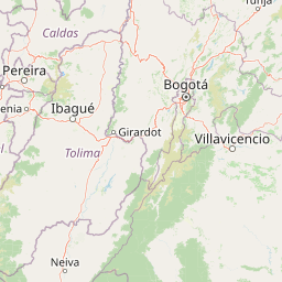
Map view of Los Nevados National Natural Park

Use this park location map to pinpoint Los Nevados National Natural Park in Colombia, understand its exact geographic position, and read its mapped placement within the surrounding landscape more clearly.

Pigeon | © OpenStreetMap contributors

Location context for Los Nevados National Natural Park

Caldas DepartmentQuindío DepartmentRisaralda DepartmentTolima Department
Park atlas

Compare diverse protected areas and their surrounding Andean landscapes, building geographic context.

Explore Related National Parks and Protected Areas Around Los Nevados National Natural Park
Browse other national parks and protected areas geographically connected or ecologically similar to Los Nevados National Natural Park. This allows for comparative exploration of diverse Andean mountain conservation, volcanic terrain, and páramo ecosystems across Colombia's Cordillera Central.
National parkColombia

Tatamá National Natural Park: Colombia's Protected Natural Landscape Explorer

Mapped boundaries and regional geography of a Colombian national park.

Tatamá National Natural Park is a protected natural area situated within the Republic of Colombia. As a designated national park, it contributes significantly to the nation's protected lands. This entry provides essential geographic context, focusing on the park's mapped outlines and its role within the broader atlas of Colombian geography. Understanding Tatamá National Natural Park involves appreciating its specific landscape features and its contribution to the country's network of protected natural areas, offering a foundation for regional geographic study.

Area
519 km²
Established
1987
IUCN
II
Relief
Mountain
National parkColombia

Chingaza National Natural Park: A National Park in Colombia's Geographic Landscape

Mapped boundaries and protected terrain details for Chingaza.

Chingaza National Natural Park offers a distinct entry for exploring Colombia's protected natural areas. This page details the park's specific geographic identity, its mapped boundaries, and its significance as a national park. Understand the landscape context and regional terrain that define Chingaza National Natural Park, providing a foundation for structured discovery within the Colombian atlas.

Area
766 km²
Established
1977
IUCN
II
Relief
Mountain
Watercolor painting of green hills, trees, and distant mountains under a light sky
National parkValle del Cauca Department

Farallones de Cali National Park: Protected Landscape and Geographic Atlas

Explore mapped boundaries and regional context.

Farallones de Cali National Park offers a distinct protected landscape within Valle del Cauca Department. This page provides atlas-level detail on its geographic scope and mapped features, crucial for understanding its regional context. Dive into the protected-area specifics to grasp the natural terrain and conservation landscape that defines this significant Colombian national park.

Area
1,500 km²
Established
1968
IUCN
II
Relief
Mountain
National parkColombia

Las Orquídeas National Natural Park: Colombia's Biodiversity Hotspot and Andean Ecosystem Atlas

Explore its unique elevational gradient and protected terrain.

Las Orquídeas National Natural Park in Colombia is renowned for its dramatic elevational range, compressing multiple distinct ecosystems into a single protected area. This national park offers an exceptional view of Andean geography and Chocó biogeographic region biodiversity, transitioning from tropical rainforest to high-altitude páramo. Investigate the mapped landscape and the conservation significance of this unique natural treasure.

Area
287.53 km²
Established
1974
IUCN
II
Relief
Mountain
National parkValle del Cauca Department

Uramba Bahía Málaga National Natural Park: National Park Protected Landscape and Geography

Explore mapped natural terrain and protected boundaries.

Gain a detailed atlas understanding of Uramba Bahía Málaga National Natural Park, a designated national park in Colombia's Valle del Cauca Department. This page details its protected landscape features and geographic setting, offering insights into its mapped boundaries and regional context for dedicated geographic exploration.

Area
471 km²
Established
2010
IUCN
II
Climate
Tropical
National parkChocó Department

Utría National Natural Park: National Park Protected Landscape and Geography

Explore its mapped boundaries and regional context in Chocó.

As a designated national park, Utría National Natural Park offers a unique lens for understanding Colombia's protected landscapes. This entry provides essential geographic context, detailing the park's location within the Chocó Department and highlighting its significance as a mapped natural area. Discover the protected boundaries and regional landscape character through structured atlas data.

Area
543.8 km²
Established
1987
IUCN
II
Relief
Mountain
National parkSantander Department

Yariguíes National Park: National Park Geography and Protected Land Atlas

Explore mapped boundaries and regional landscape context.

Yariguíes National Park stands as a crucial protected area within the Santander Department, offering a distinct landscape for geographic study. As a designated national park, it provides vital context for understanding Colombia's protected lands and their regional distribution. This detailed view allows for in-depth exploration of its mapped terrain and natural geography, suitable for atlas-oriented discovery.

Area
788.37 km²
Established
2005
IUCN
II
Scope
Terrestrial
National parkCauca Department

Munchique National Natural Park: National Park with Key Protected Landscape Features

Explore mapped geography and protected area context.

Munchique National Natural Park is a designated National Park offering a distinct protected landscape within Colombia's Cauca Department. This page provides essential context for understanding its geographic footprint, regional setting, and its significance as a mapped natural area. Dive into the atlas details and explore the unique geography that defines this protected entity.

Area
440 km²
Established
1977
IUCN
II
Relief
Mountain

Common questions about visiting, size, designation, and location context for Los Nevados National Natural Park

Los Nevados National Natural Park FAQs for park facts, access, geography, and protected area context
Find quick answers about Los Nevados National Natural Park, including protected-area facts, park geography, trail and visitor context, and how the park fits into its surrounding country and regional landscape.
MoriAtlas Explorer

Continue Your Protected Areas Search Across the Global Atlas

Deepen your exploration by continuing the structured search for national parks and protected areas worldwide. Utilize the comprehensive filtering capabilities to compare different conservation landscapes and refine your understanding of global park geography. Discover more about the distribution and characteristics of protected natural areas.

Global natural geography