

Mori Atlas logo
Wildlife reserveLostwood Wilderness

A preserved roadless mosaic of northern mixed grass prairie and glacial wetlands within the Great Plains.

Lostwood Wilderness Wildlife Reserve and Protected Prairie Landscape in North Dakota

Lostwood Wilderness represents a vital protected landscape within the prairie pothole region of northwestern North Dakota. Spanning a significant portion of the larger wildlife refuge complex, this area preserves an undeveloped stretch of northern mixed grass prairie and diverse wetland habitats shaped by glacial history. It serves as a core site for understanding the geography of the northern plains and the conservation of essential waterfowl breeding ecosystems.

wilderness areaprairie pothole regionmixed-grass prairiewetlandswaterfowl habitatnational wildlife refuge

Lostwood Wilderness

Wildlife reserve

Park overview

Structured park overview, official facts, and landscape profile for Lostwood Wilderness

Lostwood Wilderness park facts, protected area profile, and essential visitor context

Review the core facts for Lostwood Wilderness, including designation, size, terrain, visitor scale, habitats, and operating context in one park-focused overview.

About Lostwood Wilderness

Lostwood Wilderness occupies a small but strategically placed footprint within Lostwood National Wildlife Refuge in northwestern North Dakota. Although it covers just a few thousand acres, the wilderness was specifically set aside to preserve a roadless, unmanaged portion of one of the most important breeding areas for ducks and other waterfowl in North America. By preventing road-building, motorized access, logging, and mining, it ensures that key habitat remains in a natural state within a much larger actively managed refuge.

The broader setting is defined by the prairie pothole region, a landscape shaped by the retreat of Pleistocene glaciers. Across this part of the northern Great Plains, glacial action left behind a rolling terrain pocked with thousands of shallow depressions that fill with snowmelt and rainwater to form seasonal and semi-permanent wetlands. These wetlands, surrounded by native grasslands, create the conditions that have made the area a legendary waterfowl production zone.

Within that wider landscape, the Lostwood Wilderness functions as a core of true wildness. It is administered by the U.S. Fish and Wildlife Service rather than by a national forest or the Bureau of Land Management, reflecting its origin as part of a national wildlife refuge. The wilderness designation was added in 1975 to lock in a higher level of protection for a representative slice of the refuge's prairie and wetland habitat.

For visitors and ecologists alike, Lostwood Wilderness is significant not because of dramatic scenery but because of its ecological role. By keeping a portion of this prairie pothole landscape free from development, it helps preserve the breeding habitat that links the northern Great Plains to migratory waterfowl populations across a much larger continental flyway.

Quick facts and research context for Lostwood Wilderness

Lostwood Wilderness is a 5,577 acre wilderness area located in Burke County in northwestern North Dakota, near the small city of Bowbells. It was designated by Congress in 1975 and is administered by the U.S. Fish and Wildlife Service as part of Lostwood National Wildlife Refuge.

The wilderness sits within the prairie pothole region of the northern Great Plains, a glacially formed landscape of mixed-grass prairie and numerous shallow wetlands. Its primary purpose is to keep a portion of the refuge landscape in a wild, undeveloped condition, ensuring that habitat for breeding waterfowl and other native prairie species is protected from roads, motorized access, logging, and mining.

Protection and recognition

Documented terrestrial protection metrics and official conservation assignments

Lostwood Wilderness Protection Status and International Recognition

Lostwood Wilderness maintains documented terrestrial protection status within official conservation frameworks. Official records assemble available designation history and management scope without external assumptions.

Protection details

Protection scope
Terrestrial
Park context

Deeper park guide and search-rich context for Lostwood Wilderness

Lostwood Wilderness history, landscape, wildlife, and travel context

Explore Lostwood Wilderness through its history, landscape character, ecosystems, wildlife, conservation priorities, cultural context, and seasonal travel timing in a structured park guide built for atlas discovery and search intent.

Why Lostwood Wilderness stands out

Lostwood Wilderness is best known for protecting an undeveloped portion of the prairie pothole landscape that supports exceptional waterfowl breeding habitat. The surrounding refuge complex ranks among the most important duck and waterfowl production areas in North America, and the wilderness guarantees that part of that habitat remains roadless and unmanaged for extractive use. The area is also recognized for preserving a representative example of northern mixed-grass prairie, with its associated wetlands and native grassland communities, in a region where most of the original prairie has been altered by farming. This combination of upland prairie and wetland mosaic gives the wilderness a distinctive identity that goes well beyond its modest size.

Lostwood Wilderness history and protected-area timeline

Lostwood Wilderness was created by an act of the United States Congress in 1975, adding a designated wilderness layer to an area that was already part of Lostwood National Wildlife Refuge. This designation came at a time when Congress was expanding the National Wilderness Preservation System under the framework established by the 1964 Wilderness Act.

The wilderness designation did not create the area's conservation importance from scratch. The surrounding refuge had long been recognized for its exceptional waterfowl breeding habitat, set within a glacially carved prairie pothole landscape. By legally protecting a portion of that landscape from roads, motorized vehicles, logging, mining, and other forms of development, the 1975 designation ensured that at least part of the refuge would remain in a wild and unimproved condition, consistent with the strict standards of the Wilderness Act.

Lostwood Wilderness landscape and geographic character

The landscape of Lostwood Wilderness is defined by the gently rolling terrain and patchwork of wetlands typical of the prairie pothole region in northwestern North Dakota. Rather than dramatic mountains or canyons, the area offers the more subtle topography of the northern Great Plains, where glacial history has produced a landscape of low relief, native grasslands, and countless shallow depressions.

These depressions, known as prairie potholes, are the area's most distinctive physical feature. Many fill seasonally with snowmelt and rainfall, while others hold water more consistently through the breeding season. The mixture of upland prairie and small wetlands gives the wilderness a textured, mosaic-like character, even though the elevation changes across the area are modest.

Lostwood Wilderness ecosystems, habitats, and plant life

Lostwood Wilderness reflects the ecological character of the northern mixed-grass prairie and its associated wetland systems. The uplands support native grass and forb communities typical of this part of the Great Plains, while the prairie potholes add a wetland dimension that greatly increases habitat diversity within a small area.

Together, the prairie uplands and pothole wetlands form a complementary ecological system. The uplands provide nesting cover and foraging habitat, while the wetlands supply the open water, aquatic plants, and invertebrate life that waterfowl require during the breeding season. This combination is what gives the broader refuge, and the wilderness within it, its regional and even continental ecological significance.

Lostwood Wilderness wildlife and species highlights

The wildlife profile of Lostwood Wilderness is closely tied to its role as breeding habitat for waterfowl. The prairie pothole wetlands within and around the area support a high density of nesting ducks and other waterbirds, and this region has long been considered one of the most important waterfowl production zones in North America.

Beyond waterfowl, the mix of native prairie and wetland margins provides habitat for the broader community of grassland and wetland-associated species typical of the northern Great Plains. Raptors, shorebirds, songbirds of upland and wetland edges, and typical Great Plains mammal species all find suitable conditions here. The wilderness designation helps ensure that a portion of this habitat remains undisturbed during the sensitive breeding season.

Lostwood Wilderness conservation status and protection priorities

From a conservation standpoint, Lostwood Wilderness matters because it locks in permanent protection for a representative parcel of one of the most important waterfowl breeding landscapes on the continent. By preventing roads, motorized vehicles, logging, mining, and other development, the wilderness designation maintains habitat quality in the heart of the prairie pothole region.

The area's conservation significance is amplified by the fact that most of the original mixed-grass prairie in this part of North Dakota has been converted to cropland. Preserving an undeveloped core within Lostwood National Wildlife Refuge, where the surrounding landscape is already managed for wildlife, gives the wilderness an outsized role relative to its physical size. It serves as a refuge within a refuge, guaranteeing that a piece of the prairie pothole ecosystem remains in a truly wild state.

Top sights and standout views in Lostwood Wilderness

Lostwood Wilderness stands out as a small but ecologically important piece of the National Wilderness Preservation System, offering a roadless, undeveloped window into the prairie pothole region of northwestern North Dakota. Its placement inside Lostwood National Wildlife Refuge links it directly to one of North America's most important waterfowl breeding landscapes.

The area's combination of native mixed-grass prairie and glacially formed wetland potholes gives it a distinctive habitat character that supports a rich community of breeding ducks, other waterbirds, and typical Great Plains wildlife. For anyone interested in prairie conservation, wetland ecology, or the broader story of wild places in the northern plains, Lostwood Wilderness provides a compact, high-value example.

Best time to visit Lostwood Wilderness

Visiting Lostwood Wilderness is best framed around the natural cycles of the northern Great Plains. Late spring and early summer bring active waterfowl breeding across the prairie potholes, when wetland margins and native grasslands are most lively with birdlife and growing vegetation. This period tends to best showcase the ecological character that made the area worth protecting.

Late summer and early fall shift the focus toward ripening grasses, migrating waterfowl, and cooler, calmer conditions across the prairie. Winter, meanwhile, reveals the stark, open character of the northern plains, when snow covers the rolling landscape and many wetlands freeze. Because the wilderness is roadless and undeveloped, the experience in any season is shaped less by infrastructure and more by weather, light, and the rhythms of the prairie itself.

Monthly climate preview

Long term temperature and monthly precipitation statistics for North Dakota terrain

Lostwood Wilderness Climate Normals and Measured Annual Temperature Patterns

Lostwood Wilderness records severe winter minima and warm summer maximum temperatures alongside shifting monthly precipitation volumes across its representative coordinate. Reviewing the complete twelve month climate profile reveals full long term averages for temperature and moisture variations across the landscape.
Annual mean5 °C
-12 °C21 °C
Jan-12°
Feb-9°
Mar-2°
Apr
May12°
Jun17°
Jul21°
Aug20°
Sep14°
Oct
Nov-3°
Dec-9°
Warmest month
July

20.8 °C

Coolest month
January

-12 °C

Wettest month
June

3.2 mm/day

Driest month
February

0.5 mm/day

Park location guide

Geography guide, regional context, and park location map for Lostwood Wilderness

Lostwood Wilderness park geography, regions, and map view in United States of America

Understand where Lostwood Wilderness sits in United States of America through a broader geographic reading of the surrounding landscape, nearby location context, and its mapped position within the national park landscape.

How Lostwood Wilderness fits into United States of America

The United States of America is a federal presidential republic and one of the world's largest countries by area and population. It consists of 50 states across a vast territory spanning multiple time zones, with its capital in Washington, D.C. and largest city in New York City. The nation has a diverse economy, influential political system, and significant cultural and military presence globally.

Wider geography shaping Lostwood Wilderness in United States of America

The United States occupies a vast territory in North America, bordered by Canada to the north and Mexico to the south. The 48 contiguous states stretch from the Atlantic to the Pacific Ocean, while Alaska occupies the northwestern region and Hawaii is an archipelago in the Pacific. The country encompasses diverse terrain including the Rocky Mountains, Appalachian Mountains, Great Plains, and extensive river systems.

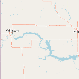
Map view of Lostwood Wilderness

Use this park location map to pinpoint Lostwood Wilderness in United States of America, understand its exact geographic position, and read its mapped placement within the surrounding landscape more clearly.

Pigeon | © OpenStreetMap contributors

Location context for Lostwood Wilderness

North Dakota
Park atlas

Compare adjacent northern plains reserves and connected grassland ecosystems.

Explore Parks Near Lostwood Wilderness and Surrounding Protected Areas

Continue geographic comparison by examining other protected areas situated across the prairie pothole region and northern Great Plains. Expanding the search helps reveal broader regional conservation contexts and similar wetland landscapes beyond Lostwood Wilderness.
Protected landscapeNorth Dakota
About 65 km away#1 closest

Southwest

Little Missouri National Grassland: Geography and Protected Landscape Context

Exploring North Dakota's expansive badlands and prairie terrain

Spanning over a million acres, Little Missouri National Grassland stands as a massive protected landscape in western North Dakota. This area showcases the complex transition where open mixed-grass prairie meets the eroded, rugged badlands of the Little Missouri River corridor. Home to White Butte, the state's highest point, the grassland offers a unique topographic profile of buttes, canyons, and canyons that defines the region's broader geographic and conservation character.

Area
4,163.34 km²
Established
1960
Relief
Upland
Climate
Temperate
National parkNorth Dakota
About 130 km away#2 closest

South

Theodore Roosevelt National Park: Mapped Protected Landscape in North Dakota

Explore the geography and protected natural boundaries.

Theodore Roosevelt National Park represents a distinct protected landscape within North Dakota, offering a valuable entry point for exploring its unique geographic setting. This page provides a concentrated view of the park's mapped boundaries and its contribution to regional natural context. It is designed for users seeking detailed atlas-level information and a clear understanding of the park's protected-area status and geographic significance within the United States.

Area
285.08 km²
Established
1978
IUCN
II
Visitors
668.7K annual
Wildlife reserveSaskatchewan
About 154 km away#3 closest

North

Moose Mountain Creek National Wildlife Area Protected Habitat and Geographic Atlas

A preserved prairie wetland complex in southeastern Saskatchewan.

Moose Mountain Creek National Wildlife Area is a federal reserve in Saskatchewan that protects a rare assembly of four distinct habitat types. The land features a functional mix of freshwater marshes, native mixed-grass prairie, and trembling aspen groves. This structured protected area highlights the importance of preserving remnant prairie ecosystems within a broader agricultural region, providing a critical baseline for understanding local geography.

Area
1.63 km²
Established
2025
IUCN
IV
Relief
Lowland
Wildlife reserveSaskatchewan
About 225 km away#4 closest

Northwest

Zugvogelschutzgebiet Indian Head: A Wildlife Reserve in Saskatchewan Prairie Landscapes

Examining mapped boundaries and protected wetland terrain

Zugvogelschutzgebiet Indian Head represents a significant conservation footprint within the Saskatchewan prairie region. This wildlife reserve integrates managed wetlands and historic nursery grounds, showcasing how agricultural landscapes support migratory bird populations. Gain insight into its terrain, ecoregion placement, and the geographic history of these protected lands through our structured atlas data.

Area
0.32 km²
Established
1924
Relief
Lowland
Scope
Terrestrial
Wildlife reserveSaskatchewan
About 250 km away#5 closest

Northwest

Wascana Lake Migratory Bird Sanctuary: Geographic Overview and Protected Wetland Boundaries

A vital wildlife reserve located in Regina, Saskatchewan

Explore the unique geography of Wascana Lake Migratory Bird Sanctuary, where a managed reservoir creates a rich wetland habitat for migratory waterfowl. This protected area stands as a significant ecological site within the Saskatchewan prairie landscape, offering a rare look at riparian terrain integration inside a major urban center.

Area
1.04 km²
Established
1956
Relief
Lowland
Climate
Temperate
National parkManitoba
About 265 km away#6 closest

Northeast

Riding Mountain National Park: Manitoba National Park Protected Landscape and Geography

Discover mapped boundaries and regional context for this national park.

Delve into the geography of Riding Mountain National Park, a protected national park located in Manitoba. This page provides detailed insights into its mapped boundaries and its significance as a protected landscape within the region. Understand its place within the broader natural terrain and atlas context of Manitoba, offering a focused view for geographic exploration and conservation landscape study.

Area
2,969 km²
Established
1933
IUCN
II
Visitors
336.6K annual
Protected areaEstonia
About 282 km away#7 closest

North

Zugvogelschutzgebiet Upper Rousay Lake Protected Area: Regional Map and Geography

Examining the protected landscapes and territorial extent in Estonia.

This resource provides a comprehensive view of the Zugvogelschutzgebiet Upper Rousay Lake protected area in Estonia. Focus on the defined boundaries, mapped terrain, and regional geographic context that identify this site. We provide a structured overview for researchers and geography enthusiasts to understand the spatial distribution and protected land status of this specific wetland environment.

Area
5.73 km²
Established
1948
Relief
Lowland
Climate
Temperate
Wildlife reserveNorth Dakota
About 293 km away#8 closest

South

Cedar River National Grassland: A Protected Prairie Landscape in Southern North Dakota

Mixed-grass prairie geography and regional watershed context

Cedar River National Grassland preserves a representative mosaic of upland plains and rolling hills in southern North Dakota. As part of the wider Dakota Prairie Grasslands, this wildlife reserve provides insight into northern prairie topography and intermittent stream ecosystems that define the regional character of the Great Plains.

Area
27.18 km²
Relief
Lowland
Climate
Temperate
Scope
Terrestrial

Common questions about visiting, size, designation, and location context for Lostwood Wilderness

Lostwood Wilderness FAQs for park facts, access, geography, and protected area context

Find quick answers about Lostwood Wilderness, including protected-area facts, park geography, trail and visitor context, and how the park fits into its surrounding country and regional landscape.
MoriAtlas Explorer

Continue Your Protected Areas Search Across the Global Atlas

Deepen your exploration by continuing the structured search for national parks and protected areas worldwide. Utilize the comprehensive filtering capabilities to compare different conservation landscapes and refine your understanding of global park geography. Discover more about the distribution and characteristics of protected natural areas.

Global natural geography
