Mori Atlas logo
National parkLovćen National Park

Mapping the dramatic limestone cliffs, forested slopes, and high-elevation karst geography of the Dinaric Alps.

Lovćen National Park: A Comprehensive Geographic Atlas of Montenegro Protected Mountain Terrain

Lovćen National Park encompasses the dramatic limestone peaks of Mount Lovćen in southwestern Montenegro, protecting a high-altitude landscape defined by rugged karst topography. This protected area spans deep ravines and forested slopes that transition from Mediterranean vegetation to subalpine communities. The site serves as a vital geographic anchor, featuring steep cliffs and rocky terrain that dominate the regional transition between the coastal Adriatic and the mountainous Balkan interior.

Karst LandscapeMountain ParksBalkan Protected AreasCultural Heritage SitesHistoric MonumentsMontenegrin Parks

Lovćen National Park

National park

Park overview

Structured park overview, official facts, and landscape profile for Lovćen National Park

Lovćen National Park park facts, protected area profile, and essential visitor context

Review the core facts for Lovćen National Park, including designation, size, terrain, visitor scale, habitats, and operating context in one park-focused overview.

About Lovćen National Park

Lovćen National Park occupies a special place in Montenegrin culture and geography, protecting a mountain that has served as both a natural fortress and spiritual heart of the nation. The park's terrain is dominated by karst limestone, creating a landscape of precipitous cliffs, vertical faces, and the distinctive two-peaked summit of Lovćen that rises dramatically above the surrounding terrain. The upper sections of the mountain support forest communities dominated by beech and fir, while lower slopes transition through oak and hornbeam woodlands before meeting the Mediterranean scrub of the coastal zone. The park's establishment in 1952 reflected both the ecological importance of this montane ecosystem and the profound cultural significance of the Lovćen mountain in Montenegrin history and identity. The landscape's dramatic character, with its steep ascents and panoramic viewpoints, has inspired generations of Montenegrins and visitors alike.

Quick facts and research context for Lovćen National Park

Lovćen National Park covers the upper Lovćen mountain massif in Montenegro, protecting a landscape of cultural and ecological significance. The park's centerpiece is Jezerski vrh at 1,749 meters, where the Petar II Petrović-Njegoš mausoleum stands as a powerful architectural landmark. The protected area features karst limestone formations, diverse forest communities, and serves as a symbol of Montenegrin national identity. The park was established in 1952 and remains one of Montenegro's oldest protected areas.

Protection and recognition

Documented terrestrial protection scope and official recognition details

Lovćen National Park Protection Status and International Recognition Data

Lovćen National Park maintains a documented terrestrial protection scope within the regional protected area framework. Official conservation records outline the established designation status and international recognition criteria.

Protection details

Protection scope
Terrestrial
Transboundary protection
No
Park context

Deeper park guide and search-rich context for Lovćen National Park

Lovćen National Park history, landscape, wildlife, and travel context

Explore Lovćen National Park through its history, landscape character, ecosystems, wildlife, conservation priorities, cultural context, and seasonal travel timing in a structured park guide built for atlas discovery and search intent.

Why Lovćen National Park stands out

Lovćen National Park is best known for the Petar II Petrović-Njegoš Mausoleum, an imposing structure positioned atop Jezerski vrh that houses the tomb of Montenegro's most revered ruler and philosopher-poet. The park is also celebrated for its dramatic karst landscape of sheer limestone cliffs, deep gorges, and the distinctive Lovćen peaks that dominate the coastal-inland transition zone of Montenegro. The combination of natural ruggedness and cultural symbolism makes this park a defining feature of Montenegrin identity.
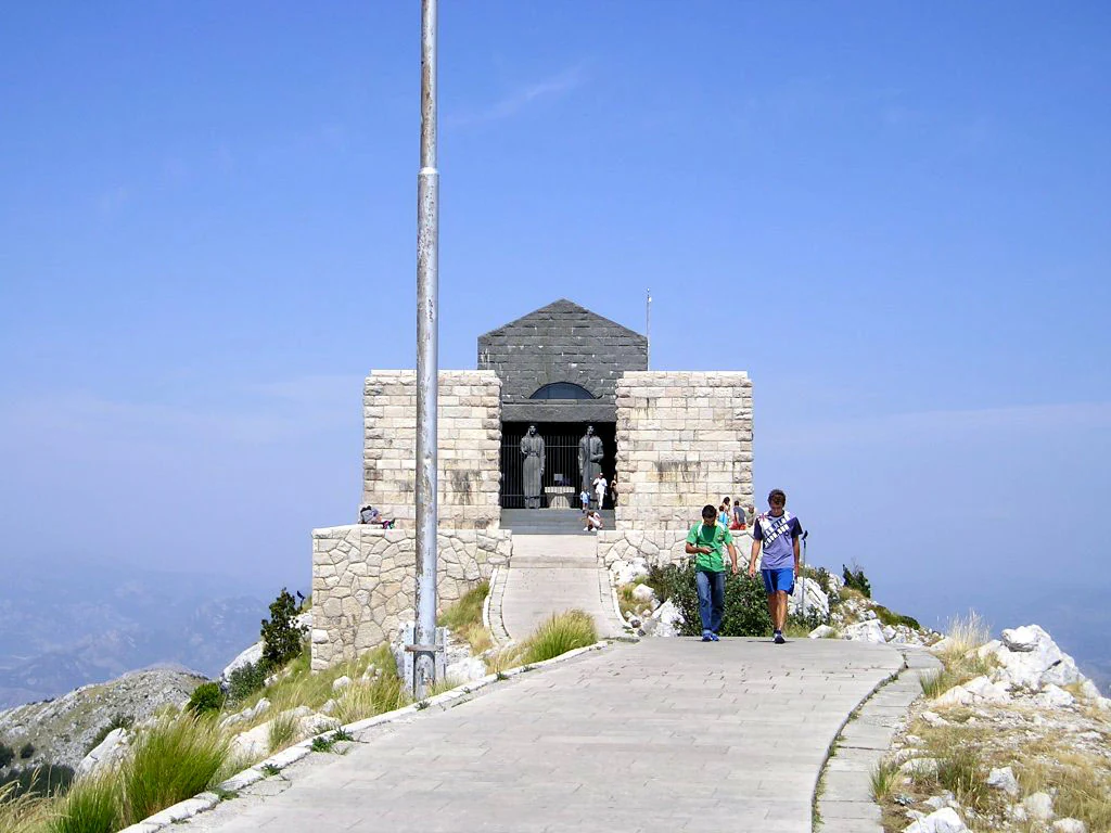
Stone mausoleum structure with people walking on a paved path toward it under clear blue sky
Mausoleum of Petar II Petrović-Njegoš in Lovćen National Park with visitors approaching

Lovćen National Park history and protected-area timeline

The establishment of Lovćen National Park in 1952 reflected the post-World War II recognition of Lovćen's dual significance as both a natural treasure and a cultural landmark. The mountain had long held sacred status in Montenegrin tradition, and the placement of Njegoš's mausoleum at the summit in 1974 further cemented the site's role as a place of national pilgrimage. The mausoleum, replacing an earlier church that had been destroyed, was constructed to honor the poet-philosopher who had envisioned a Montenegrin state unified under spiritual and cultural ideals. The park's boundaries have been maintained to protect both the natural environment of the mountain slopes and the cultural landscape surrounding this paramount national monument.

Lovćen National Park landscape and geographic character

The Lovćen landscape is defined by its dramatic karst topography, a geological character shared with much of the Dinaric Alps region. The mountain rises as a compact limestone mass with two principal peaks, and the park protects the upper portions of this terrain. Steep cliffs and rocky faces dominate the upper elevations, while lower slopes feature forested terrain descending through alternating bands of vegetation. The geological substrate of karst limestone has produced a landscape of sinkholes, caves, and rugged terrain that gives Lovćen its distinctive visual character. From the upper peaks, views extend across the Montenegrin landscape, encompassing both coastal vistas and the mountainous interior, making the park a natural observation point of exceptional importance.

Lovćen National Park ecosystems, habitats, and plant life

The ecological character of Lovćen National Park reflects the transitional position of this mountain between Mediterranean and continental climatic zones. The park supports diverse forest communities that vary with elevation and aspect, with beech forests dominating the main forest belt and fir present in appropriate microhabitats. The karst landscape creates specialized habitats on cliff faces, in caves, and across exposed limestone terrain. This diversity of habitats supports a correspondingly varied community of plant and animal species adapted to the montane environment. The protected area serves as an important corridor for species moving between coastal and interior mountain ecosystems.

Lovćen National Park wildlife and species highlights

The wildlife of Lovćen reflects the montane character of this protected area within the Dinaric Alps region. The forests and rocky terrain provide habitat for typical Balkan mountain fauna, including various bird species associated with forest and cliff environments. The karst cave systems offer shelter for cave-dwelling species, while the diverse forest structure supports mammalian species adapted to montane woodland. The park's position along the Adriatic flyway also brings migratory bird activity during appropriate seasons. While specific species lists would require detailed survey data, the overall ecological character supports a representative community of Balkan mountain wildlife.

Lovćen National Park conservation status and protection priorities

Lovćen National Park represents one of Montenegro's oldest protected areas and embodies the nation's approach to balancing natural preservation with cultural heritage protection. The park's karst ecosystems contain specialized species and communities that depend on the intact forest and rocky habitats within the protected boundaries. The protection of Lovćen also serves broader conservation goals by maintaining forest cover on a mountainous landscape that otherwise faces pressures from logging and development. The dual designation recognizing both natural and cultural values reflects an integrated approach to landscape conservation that preserves the holistic character of this significant Montenegrin landmark.

Lovćen National Park cultural meaning and human context

Mount Lovćen holds profound significance in Montenegrin cultural identity, having served as a symbolic and strategic center for the Montenegrin state across centuries. The mountain's fortress-like appearance made it a natural defensive position, while its prominent position above the landscape gave it spiritual importance. The placement of the Petar II Petrović-Njegoš mausoleum at the summit represents the culmination of this cultural significance, transforming the natural peak into a site of national pilgrimage. Njegoš, who ruled as both prince-bishop and poet, embodied the Montenegrin aspirations for cultural and political identity during the 19th century, and his tomb on this commanding peak connects the natural landscape with the nation's historical narrative.

Top sights and standout views in Lovćen National Park

The Petar II Petrović-Njegoš Mausoleum atop Jezerski vrh remains the defining feature of Lovćen National Park, an architectural landmark of national importance. The panoramic views from the upper peaks encompass the full sweep of Montenegrin terrain from coast to mountains. The karst landscape of dramatic limestone peaks and cliffs represents outstanding Dinaric alpine terrain. The forest communities of beech and fir create a green mantle across the mountain slopes. The cultural heritage of the site connects natural beauty with Montenegrin historical identity.

Best time to visit Lovćen National Park

Lovćen National Park can be visited throughout the year, with each season offering a different character to the mountain experience. The summer months bring stable weather and the most accessible conditions for hiking and sightseeing at higher elevations. Autumn often brings clear skies and the spectacle of forest color as the deciduous communities change. Winter transforms the landscape with snow, though conditions may limit access to higher elevations. Spring brings renewal to the vegetation and can be particularly attractive as the mountain flora awakens. The mausoleum remains accessible in most seasons, though visitors should check current access conditions, particularly in winter months when snow may affect road access to upper parking areas.
Monthly climate preview

Long-term monthly temperature averages and precipitation measurements for Lovćen National Park

Lovćen National Park Climate Normals and Annual Temperature Patterns

Representative coordinate records outline measured monthly temperature swings and precipitation totals across the protected landscape. Detailed twelve-month climate normals provide broader analytical depth for evaluating long-term environmental conditions.
Annual mean13 °C
4 °C24 °C
Jan
Feb
Mar
Apr11°
May16°
Jun20°
Jul23°
Aug24°
Sep19°
Oct14°
Nov10°
Dec
Warmest month
August

23.9 °C

Coolest month
January

4.1 °C

Wettest month
November

6.1 mm/day

Driest month
July

1.3 mm/day

Park location guide

Geography guide, regional context, and park location map for Lovćen National Park

Lovćen National Park park geography, regions, and map view in Montenegro

Understand where Lovćen National Park sits in Montenegro through a broader geographic reading of the surrounding landscape, nearby location context, and its mapped position within the national park landscape.

How Lovćen National Park fits into Montenegro

Montenegro is a unitary parliamentary republic in Southeast Europe on the Balkan Peninsula. With a population of approximately 623,000 and an area of 13,883 km², it borders five countries and has a coastline on the Adriatic Sea. The capital and largest city is Podgorica, while Cetinje serves as the old royal capital. The country declared independence in 2006 following the breakup of Serbia and Montenegro.

Wider geography shaping Lovćen National Park in Montenegro

Montenegro is located on the Balkan Peninsula in Southeast Europe. It is bordered by Serbia to the northeast, Bosnia and Herzegovina to the northwest, Kosovo to the east, Albania to the southeast, and Croatia to the west. The country has a coastline along the Adriatic Sea to the southwest. The terrain is predominantly mountainous, with the Dinaric Alps running through the country.

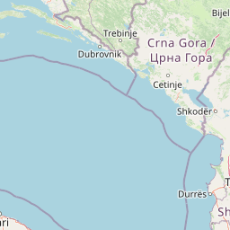
Map view of Lovćen National Park

Use this park location map to pinpoint Lovćen National Park in Montenegro, understand its exact geographic position, and read its mapped placement within the surrounding landscape more clearly.

Pigeon | © OpenStreetMap contributors

Visual records of limestone peaks, karst terrain, and mountain environments

Lovćen National Park Landscape Photos and Protected Area Scenery

Visual documentation of Lovćen National Park reveals the dramatic limestone cliffs, rugged karst topography, and forested mountain slopes defining this Dinaric Alps protected area. Examining national park photography provides essential context for understanding the high-elevation terrain, monumental architecture, and expansive coastal vistas shaping the regional landscape.

Stone mausoleum structure with people walking on a paved path toward it under clear blue sky

Rocky mountain peak with a structure on top, surrounded by green vegetation and a winding road, under a clear sky

Park atlas

Compare regional karst terrain and adjacent protected areas across the Dinaric Alps.

Explore Other Parks Near Lovćen National Park and Surrounding Protected Landscapes

Browse nearby national parks and protected areas to compare rugged limestone geography across the surrounding region. Extending the geographic review beyond Lovćen National Park reveals broader patterns in Balkan mountain terrain and forest reserves.
National parkMontenegro
About 1.2 km away#1 closest

West

Lovćen National Park: Karst Geography and Protected Mountain Landscapes in Montenegro

Dinaric massif rising above the Adriatic coastal basin.

Lovćen National Park encompasses a dense, rocky landscape of limestone and dolomite in southwestern Montenegro. Known as the namesake for the country itself, the massif creates a sharp geographic boundary between the Adriatic Sea and the inland highlands. The area offers a profound look at Dinaric karst features, including dramatic cliffs and endemic botanical habitats, preserved within a culturally rich mountain setting.

Area
62.2 km²
Established
1952
Relief
Mountain
Climate
Mediterranean
A pale, wide watercolor illustration showing rolling green hills and a winding stream, framed by distant, hazy mountain ridges.
Protected landscapeMontenegro
About 31 km away#2 closest

Northwest

Orjen Protected Landscape: Montenegro Mountain Geography and Karst Atlas

High-altitude karst massif and Dinaric coastal mountain.

Orjen rises as a dramatic limestone block above the Adriatic coast of Montenegro, forming a high-altitude sanctuary defined by intensive Pleistocene glaciation and record-breaking annual precipitation. This protected landscape encompasses extensive dolines, roches moutonnées, and specialized cold-air refugia, providing a detailed study of sub-Mediterranean highland vegetation and complex subterranean karst drainage.

Area
400 km²
Established
2017
Relief
Mountain
Climate
Mediterranean
A watercolor painting showing a soft, panoramic landscape of low hills, green fields, and water, with a light and ethereal style.
Protected areaMontenegro
About 31 km away#3 closest

East

Cijevna Protected Area: Mapping the River Canyon and Balkan Highlands Geography

An alpine river system spanning the Montenegro and Albania border

The Cijevna represents a striking natural corridor carved into the Prokletije mountains. This protected landscape is defined by its deep V-shaped valleys, high-altitude gorges, and seasonal discharge patterns that sustain important freshwater biodiversity across the Balkan highlands.

Watercolor painting of a lake landscape with green marshes in the foreground, small islands in the middle, and rolling hills in the background.
National parkMontenegro
About 48 km away#4 closest

Southeast

Lake Skadar National Park: An Atlas Overview of Montenegro's Largest Freshwater Wetland

Karst Terrain and Transboundary Protected Landscapes

Lake Skadar stands as a monumental geographic feature in Montenegro, serving as the largest lake in Southern Europe. This national park protects a diverse ecosystem ranging from submerged karst springs to expansive seasonal marshes. Its status as a transboundary system offers insights into Mediterranean hydrology and endemic freshwater biodiversity within the unique Balkan karst basin.

Area
450 km²
Established
1983
Relief
Lowland
Climate
Mediterranean
Watercolor painting showing a mountainous landscape with a lake, green hills, and pink flowers
National parkAlbania
About 57 km away#5 closest

East

Alps of Albania National Park: Explore Albania's Largest Protected Alpine Wilderness

Dramatic karst, glacial valleys, and high-altitude ecosystems await.

The Alps of Albania National Park offers an expansive view into one of the Balkans' most significant mountain protected areas. This national park encompasses a spectacular landscape characterized by towering limestone peaks, deep glacial valleys carved over millennia, and intricate karst formations like Grunas Canyon. Its pristine wilderness protects diverse high-altitude ecosystems and unique geological features, serving as a key destination for understanding regional geography and protected landscapes.

Area
828.447 km²
Established
2022
IUCN
II
Relief
Mountain
Watercolor painting of a wide wetland area with distant purple mountains, green grassy banks, and water channels.
Protected landscapeUlcinj
About 65 km away#6 closest

Southeast

Saline Ulcinj: Coastal Wetland Geography and Protected Landscape Mapping

A large-scale saline nature park near Ulcinj in southern Montenegro.

Saline Ulcinj represents a significant coastal wetland complex nestled in the Buna delta. This protected landscape is defined by its unusual industrial history and modern transition into a vital nature reserve, characterized by expansive saline pools and shallow mudflats. Its geographic footprint offers a clear look at how coastal water management shapes the surrounding terrain and provides essential stopover habitats for Adriatic migratory birds.

Area
15 km²
Established
2019
Relief
Lowland
Water
Water-dominated
A watercolor painting showing a panoramic view of green rolling hills and a body of water under a soft, light sky.
Nature reserveShkodër District
About 65 km away#7 closest

Southeast

Lake Shkodër Nature Reserve: Mapping Protected Wetland and Riverine Geography in Albania

A critical Balkan freshwater protected area.

The Lake Shkodër Nature Reserve serves as a foundational protected landscape in northern Albania, encompassing the extensive shoreline and riverine floodplains of Lake Skadar. This geographic entity showcases a transition from fertile lowlands to mountainous ridges, offering a detailed look at how hydrologic processes and alpine proximity define Balkan wetland habitats.

Area
265.35 km²
Established
2005
IUCN
IV
Relief
Lowland
A horizontal watercolor painting of a serene river landscape with green trees on both banks and small boats floating on the water at sunset.
Protected landscapeShkodër County
About 73 km away#8 closest

Southeast

Buna River-Velipojë Protected Landscape: Albania Coastal and Wetland Geography

Mapped protected landscape in Shkodër County

The Buna River-Velipojë Protected Landscape encompasses the crucial junction of riverine systems and the Adriatic Sea. This protected area features a mosaic of marshes, lagoons, and alluvial forests that form a significant migratory corridor in northwestern Albania.

Area
230.27 km²
Established
2005
IUCN
V
Relief
Lowland

Common questions about visiting, size, designation, and location context for Lovćen National Park

Lovćen National Park FAQs for park facts, access, geography, and protected area context

Find quick answers about Lovćen National Park, including protected-area facts, park geography, trail and visitor context, and how the park fits into its surrounding country and regional landscape.
MoriAtlas Explorer

Continue Your Protected Areas Search Across the Global Atlas

Deepen your exploration by continuing the structured search for national parks and protected areas worldwide. Utilize the comprehensive filtering capabilities to compare different conservation landscapes and refine your understanding of global park geography. Discover more about the distribution and characteristics of protected natural areas.

Global natural geography