
Mori Atlas logo
Protected landscapeLuerwald und Bieberbach

A vast, continuous forest reserve in the northern Sauerland region of Germany.

Luerwald und Bieberbach Protected Landscape: Geographic Profile and Mapped Woodland Terrain

(EU-Vogelschutzgebiet "Luerwald und Bieberbach")

Luerwald und Bieberbach represents one of the largest coherent forest reserves in central North Rhine-Westphalia. This protected landscape is defined by its deep, settlement-free deciduous woodland and a dense, near-natural network of forest streams including the Bieberbach. Through its status as a Special Protection Area, the territory preserves critical breeding habitats for various bird species, forming a vital ecological corridor within the transition between the Sauerland hills and the Ruhr valley.

beech forestbroadleaf forestforest reserveSpecial Protection AreaNatura 2000EU Birds Directive
A stylized vector illustration of a lush mountain valley featuring a winding stream in the foreground, surrounded by grassy banks with flowers and dense coniferous forests leading up to cliffs.

Luerwald und Bieberbach

Protected landscape

Park overview

Structured park overview, official facts, and landscape profile for Luerwald und Bieberbach

Luerwald und Bieberbach park facts, protected area profile, and essential visitor context

Review the core facts for Luerwald und Bieberbach, including designation, size, terrain, visitor scale, habitats, and operating context in one park-focused overview.

About Luerwald und Bieberbach

Luerwald und Bieberbach is a European Special Protection Area in central North Rhine-Westphalia, Germany, designated under the European Union's Birds Directive. The site covers roughly 2,634 hectares split into two separate but ecologically linked sections, and lies in the northern part of the Sauerland uplands, between the Ruhr valley to the north and the city of Menden to the west. Geographically, it stretches across the Hochsauerlandkreis, Märkischer Kreis, and Kreis Soest districts, with the two federal motorways A445 and A46 marking parts of the eastern boundary and the L544 state road closing it off to the south.

The reserve takes its name from two historical landscape elements. The Luerwald, also spelled Lürwald or Lüerwald, is a remnant of what was once a vast forest tract of the former Grafschaft Arnsberg and Herzogtum Westfalen, now reduced to a coherent forest zone between Neheim and Menden. The Bieberbach is the small forest stream that runs through the protected area and joins the Hönne near Lendringsen. The combined site is remarkable for being largely free of settlements and rarely fragmented by roads, giving it value as a continuous, low-disturbance habitat.

Ecologically, the reserve is dominated by broadleaf forest, covering roughly 65 percent of the area, complemented by conifer plantations (around 25 percent) and small shares of moist grassland, arable land, and rocky or scree habitats. Habitat types listed for the site include Hainsimsen beech forest, Waldmeister beech forest, subatlantic pedunculate oak forest, bog woodland, and the priority alluvial forests dominated by alder and ash. This forested mosaic, threaded by small streams, is the basis for the reserve's importance to woodland and stream birds.

The site is of supra-regional ornithological significance. Eleven bird species listed under Annex I of the EU Birds Directive breed within its borders, including the black storch, common kingfisher, red kite, black kite, middle spotted woodpecker, grey-headed woodpecker, black woodpecker, Eurasian hobby, Eurasian pygmy owl, corncrake, and red-backed shrike. The combination of old-growth forest, abundant dead wood, and quiet streams allows many of these species to persist in central Europe where they have declined elsewhere.

Quick facts and research context for Luerwald und Bieberbach

Luerwald und Bieberbach is an EU Birds Directive Special Protection Area (Natura 2000 site DE-4513-401) in North Rhine-Westphalia, Germany. It was designated by the Regierungspräsidium Arnsberg in 2004 and covers approximately 2,634 hectares across two separate sections of forest.

The reserve spans three administrative districts: Hochsauerlandkreis, Märkischer Kreis, and Kreis Soest, and lies on the northern fringe of the Sauerland between the towns of Neheim and Menden. The forest is dominated by broadleaf woodland (around 65 percent of the area), with beech, oak mixed forest, and alder-ash streamside woodland as characteristic habitat types. Roughly a quarter of the site is conifer plantation, with small shares of moist grassland, arable land, and rocky or scree habitats completing the mosaic.

Eleven Annex I bird species are recorded as breeders here, including black stork, common kingfisher, middle spotted woodpecker, red kite, black woodpecker, grey-headed woodpecker, pygmy owl, Eurasian hobby, and corncrake. The reserve is administratively linked to the matching FFH habitat site DE-4513-301 and the Luerwald nature reserves in the Hochsauerlandkreis and Märkischer Kreis.

Protection and recognition

Examine official designation records and international protection data for Luerwald und Bieberbach.

Luerwald und Bieberbach Protection Status and Natura 2000 Recognition

Official records outline the documented protection status, management scope, and international recognition attributed to Luerwald und Bieberbach. Natura 2000 source entries verify the designated boundaries and conservation framework governing the protected area.
Park context

Deeper park guide and search-rich context for Luerwald und Bieberbach

Luerwald und Bieberbach history, landscape, wildlife, and travel context

Explore Luerwald und Bieberbach through its history, landscape character, ecosystems, wildlife, conservation priorities, cultural context, and seasonal travel timing in a structured park guide built for atlas discovery and search intent.

Why Luerwald und Bieberbach stands out

Luerwald und Bieberbach is best known as one of the largest coherent forest reserves in central North Rhine-Westphalia, designated under the EU Birds Directive for its exceptional ornithological value. The site's defining character is a combination of near-natural, undisturbed deciduous forest and a dense network of small forest streams, including the Bieberbach, which supports breeding habitat for several sensitive Annex I bird species of the European Union. The continuity of the forest cover, its high share of old and dead wood, and its mosaic of beech, oak, and alder-ash streamside woodland together provide unusually intact conditions for woodland birds such as black stork, middle spotted woodpecker, grey-headed woodpecker, black woodpecker, and pygmy owl, alongside stream-dependent species like the common kingfisher.
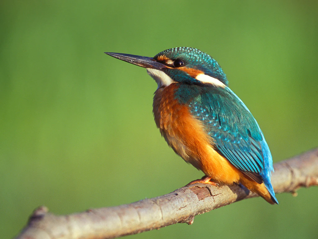
A close-up view of a common kingfisher with vibrant blue wings and orange breast perched on a thin, light-brown branch against a soft-focus green background.
A common kingfisher perched on a branch, a species found in the riparian habitats of Luerwald und Bieberbach.

Luerwald und Bieberbach history and protected-area timeline

Luerwald und Bieberbach received its current protected status in 2004, when the Regierungspräsidium Arnsberg issued the ordinance designating it as a European Special Protection Area under the EU Birds Directive (site code DE-4513-401). Its designation followed the broader European framework established by the Birds Directive, which obliges member states to safeguard wild bird populations and their habitats across the Union.

The forest itself, however, is far older than the legal designation. The Luerwald, also called Lürwald or Lüerwald, was historically part of the extensive woodlands of the Grafschaft Arnsberg and the Herzogtum Westfalen, noble and ecclesiastical territories of the medieval and early modern Holy Roman Empire. Over centuries the broader historical forest contracted, leaving today's coherent forest block in the northern edge of the Sauerland. The Bieberbach, the small stream that gives the area its second name, drains the forest and joins the Hönne at Lendringsen, providing the stream corridors that underpin much of the site's modern ecological value.

The Special Protection Area is closely tied to the matching FFH habitat site DE-4513-301 and overlaps with two nature protection areas: the Luerwald nature protection area (HSK-150) in the Hochsauerlandkreis and the Luerwald und Bieberbach nature protection area (MK-016) in the Märkischer Kreis. These layered designations reflect the area's long-standing conservation significance, but the 2004 SPA designation was the moment when its role in European bird conservation was formally codified.

Luerwald und Bieberbach landscape and geographic character

The landscape of Luerwald und Bieberbach is shaped by the rolling uplands of the northern Sauerland, where forested ridges and valleys give way to quiet, undisturbed woodland. The reserve sits on the transition between the higher Sauerland hills further south and the lower, more open Ruhr valley country to the north. Across the two protected sections, the terrain is dominated by closed forest canopy, broken only by small clearings, stream valleys, and the borders formed by motorways and state roads.

A defining physical feature is the dense network of small forest streams that drain the area. The Bieberbach, the namesake watercourse, runs through the forest with a near-natural channel pattern, including meanders, undercut banks, and root plates from fallen trees. These streams connect larger landscape elements such as the Ruhr valley to the north, the Hönne to the south, and the urban edges of Menden and Neheim. Small inclusions of moist grassland, scree, and rocky outcrops add further structural variety around the edges of the forested core.

Within the reserve, land cover is heavily weighted toward woodland. Broadleaf forest accounts for roughly two-thirds of the area, with beech, oak, and mixed deciduous stands together forming the dominant forest type. Conifer plantations cover another quarter of the site, mainly on historically cleared ground, while smaller pockets of mesophilic and wet grassland, plus a small share of arable land and inland rocky or scree habitats, complete the mosaic. The result is a large, visually quiet forest landscape with little settlement and few roads crossing its interior.
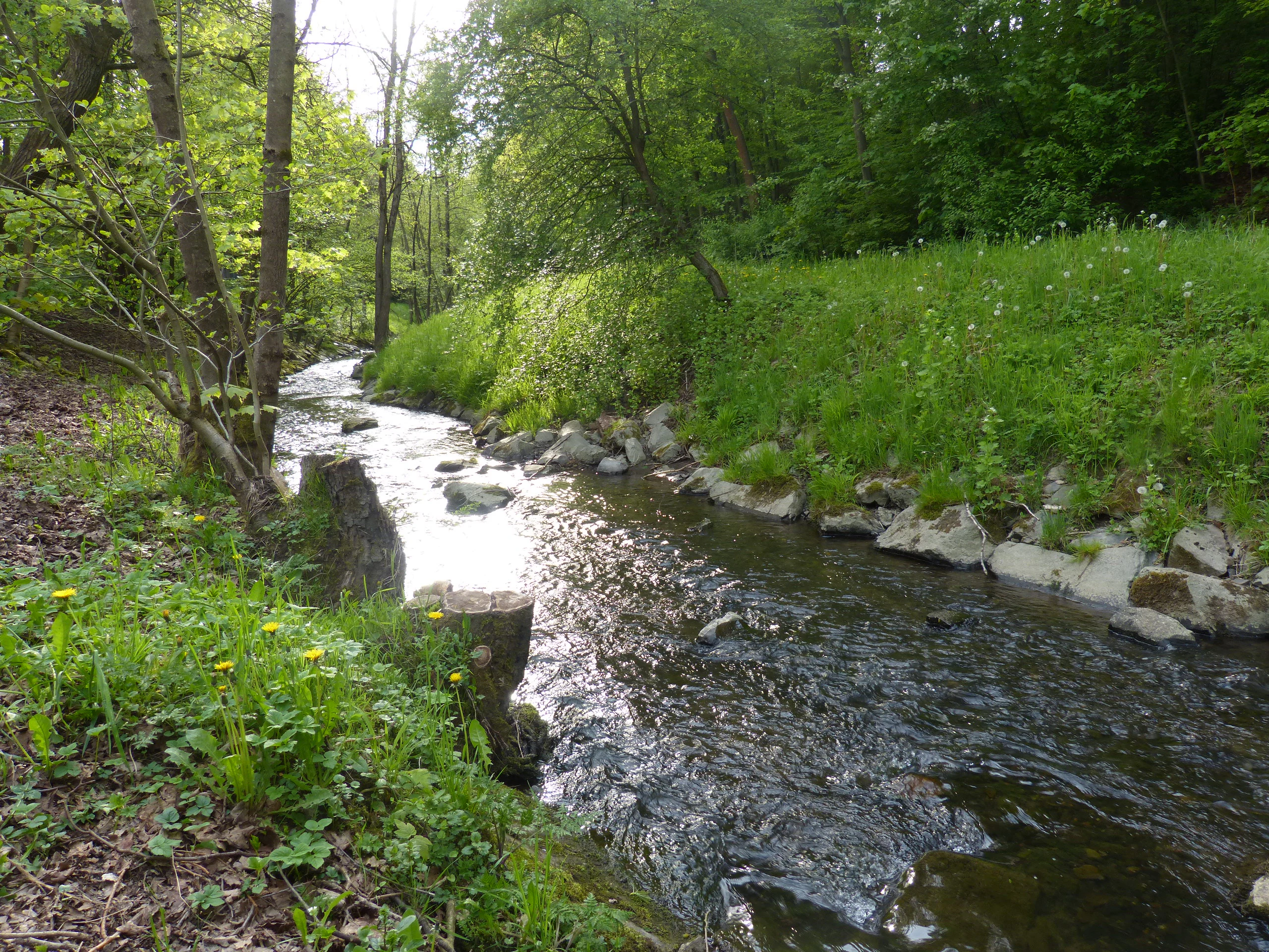
A small stream, the Bieberbach, flows through a lush green, tree-lined forest with a grassy bank in the foreground.
The Bieberbach stream flowing through the forested landscape of Luerwald und Bieberbach.

Luerwald und Bieberbach ecosystems, habitats, and plant life

Ecologically, Luerwald und Bieberbach is a coherent broadleaf forest system threaded by natural stream corridors. The site's habitat mosaic is unusually intact for a forested area in central Europe, with limited fragmentation, few settlements, and a high proportion of closed-canopy deciduous cover.

The beech-dominated woodland community is particularly important. The reserve includes Hainsimsen beech forest and Waldmeister beech forest, both classic Central European beech woodland types, alongside subatlantic pedunculate oak forest and a fringe of starwort oak-hornbeam forest. Streams and seepage zones support small patches of bog woodland and, in some sections, alluvial forests of alder and ash, a habitat type flagged as a priority for conservation within the European Union because it is considered endangered across the continent.

Stream habitats add a second ecological axis. The Bieberbach and its smaller tributaries form near-natural watercourses within the forest, with meanders, undercut banks, and naturally disturbed erosion sites. These streams are the core habitat for fish and amphibians that, in turn, support bird species that depend on clean water and rich prey bases. Around the wooded core, small areas of nutrient-poor grassland and rocky or scree habitats provide vegetation communities distinct from the forest, as well as feeding grounds for birds that mix woodland and open-country foraging.

Luerwald und Bieberbach wildlife and species highlights

The wildlife of Luerwald und Bieberbach is dominated by forest-dependent birdlife, as the site's designation under the European Union's Birds Directive makes clear. Eleven species listed under Annex I of the directive breed within the reserve, anchored around woodland and stream species.

Woodland specialists are particularly notable. Black stork, a notoriously shy wetland-forest species, breeds in the reserve alongside several large woodpeckers, including black woodpecker, grey-headed woodpecker, and middle spotted woodpecker. These are species that depend on extensive, mature deciduous stands with high amounts of old and dead wood, conditions met across much of the protected forest. Bird species that favor coniferous and mixed stands with a rich cavity tree supply, such as the pygmy owl, also use the area.

The Bieberbach stream network adds a complementary set of species. Common kingfisher uses the natural stream banks and erosion sites as nesting habitat, while the surrounding open and half-open landscapes host red kite and black kite, both raptors that nest in mature trees but feed over nearby fields and meadows. The reserve's wet and mesophilic grassland patches also support ground-nesting species that depend on extensive land use, including corncrake. Red-backed shrike is among the additional species recorded, nesting in hedges and shrubby field edges around the wooded core.

Stream and woodland fauna more broadly, including fish, amphibians, small mammals, and insects, underpin the food webs that sustain these bird communities, with kingfisher and black stork in particular tied to small fish availability and clear water. The combination of large undisturbed forest, mature trees, and clean forest streams makes the reserve an unusually continuous wildlife habitat in the region.

Luerwald und Bieberbach conservation status and protection priorities

Conservation status is central to the identity of Luerwald und Bieberbach. The site is a designated European Special Protection Area within the Natura 2000 network, with the designation issued by the Regierungspräsidium Arnsberg in 2004. The reserve is administered under code DE-4513-401 within the EU Birds Directive.

The core conservation goal is the preservation of a large, largely unfragmented, settlement-free forest complex. Key objectives include maintaining the integrity of the forest cover and its mosaic of habitat types, securing the natural flow regime of the Bieberbach and other forest streams, and protecting small but ecologically important features such as nutrient-poor hay meadows in the lowlands. Together, these measures maintain the structural conditions that support the reserve's qualifying bird species.

The reserve's value is reinforced by its overlap with related protective designations. It is paired with the matching FFH habitat site DE-4513-301 and sits within the Luerwald nature protection area (HSK-150) in the Hochsauerlandkreis and the Luerwald und Bieberbach nature protection area (MK-016) in the Märkischer Kreis. This layering of European, federal, and state-level protection reflects the area's documented value for breeding woodland birds and forest-stream habitats in a region where such large continuous forests have become rare.

Luerwald und Bieberbach cultural meaning and human context

The Luerwald carries a long cultural and historical memory beyond its ecological role, anchored in the territorial history of central Westphalia. It was once part of the woodlands associated with the Grafschaft Arnsberg and the Herzogtum Westfalen, two significant political entities of the medieval and early modern Holy Roman Empire. Over time, the broader historic forest contracted into the coherent forest block that survives today, so the surviving woodland carries the imprint of centuries of regional land use, ownership, and management change.

At a more local level, the area sits between small towns that have grown together with the landscape. Neheim, now part of Arnsberg, and Menden on the northern edge of the Sauerland define the cultural surroundings of the forest, with the Bieberbach and the Hönne stream system forming part of the regional hydrological identity. The current protected status is the latest layer in this long history, marking the area primarily as a shared regional ecological heritage rather than as a culturally inhabited space, given how little settlement the forest itself contains.

Top sights and standout views in Luerwald und Bieberbach

Luerwald und Bieberbach stands out for combining the qualities of a large Central European broadleaf forest reserve with the ecological protections of the European Natura 2000 network.

Among its most distinctive assets are a large, continuous, settlement-free forested area; a dense network of near-natural forest streams centered on the Bieberbach; high-value beech and oak woodland habitat types, including the priority alder-ash alluvial forests; and breeding populations of eleven Annex I bird species of the EU Birds Directive, including black storch, common kingfisher, several large woodpecker species, and red and black kites.

Best time to visit Luerwald und Bieberbach

The reserve is a protected natural area rather than a tourism-focused destination, and access is shaped by its role as a working forest and conservation site. Within those constraints, the late spring and early summer months are typically the most rewarding period for landscape and wildlife observation across Central European forests of this type. Active woodland breeding cycles, including those of woodpeckers and the black storch, coincide with this period, when the closed forest canopy is fully developed and stream habitats are at their most active.


Monthly climate preview

Long-term representative temperature and precipitation averages across the year

Luerwald und Bieberbach Climate Normals and Monthly Temperature Patterns

Representative coordinate records show average monthly temperatures ranging from near freezing to warm maximums alongside consistent daily precipitation distributions. Examining the complete twelve-month sequence reveals detailed climate normals and measured meteorological patterns across the protected landscape.
Annual mean9 °C
0 °C18 °C
Jan
Feb
Mar
Apr
May12°
Jun16°
Jul18°
Aug18°
Sep14°
Oct
Nov
Dec
Warmest month
July

18.2 °C

Coolest month
January

0.3 °C

Wettest month
December

2.7 mm/day

Driest month
April

1.7 mm/day

Park location guide

Geography guide, regional context, and park location map for Luerwald und Bieberbach

Luerwald und Bieberbach park geography, regions, and map view in Germany

Understand where Luerwald und Bieberbach sits in Germany through a broader geographic reading of the surrounding landscape, nearby location context, and its mapped position within the national park landscape.

How Luerwald und Bieberbach fits into Germany

Germany is a federal republic in Western and Central Europe with a population of over 83 million across sixteen constituent states. It is Europe's largest economy by nominal GDP and a major global exporter and importer. The capital is Berlin, and the country borders Denmark, Poland, Czech Republic, Austria, Switzerland, France, Luxembourg, Belgium, and the Netherlands.

Wider geography shaping Luerwald und Bieberbach in Germany

Germany is located in Western and Central Europe, spanning 357,022 km². It borders Denmark to the north, Poland and the Czech Republic to the east, Austria and Switzerland to the south, and France, Luxembourg, Belgium, and the Netherlands to the west. The country has coastlines on the Baltic Sea and North Sea to the north, with the Alps located in the southern region.

Map view of Luerwald und Bieberbach

Use this park location map to pinpoint Luerwald und Bieberbach in Germany, understand its exact geographic position, and read its mapped placement within the surrounding landscape more clearly.

Pigeon | © OpenStreetMap contributors
Recorded earthquake history

Explore Historical Earthquake Records for Luerwald und Bieberbach

Review recorded seismic events, epicentre distances, and magnitudes associated with the Luerwald und Bieberbach region. MoriAtlas provides this historical earthquake data to support geographic exploration of the northern Sauerland area and its surrounding geological context.

Luerwald und Bieberbach Earthquake History

Catalogued events

35 events

Strongest magnitude

Magnitude 4.6

Most recent event

Dec 20, 2008

This history includes earthquakes recorded inside the park or within 50 km of its borders

Visual exploration of continuous beech woodlands and near-natural stream habitats

Luerwald und Bieberbach Photos and Forest Landscape Scenery

Photographic documentation reveals the dense forest canopy, undisturbed stream corridors, and quiet deciduous habitats that define Luerwald und Bieberbach. Examining these protected area visuals helps clarify the complex terrain and specialized ecological zones of the Sauerland region.

A close-up view of a common kingfisher with vibrant blue wings and orange breast perched on a thin, light-brown branch against a soft-focus green background.

A red kite bird seen in profile while soaring against a clear blue sky.

A small stream, the Bieberbach, flows through a lush green, tree-lined forest with a grassy bank in the foreground.

Park atlas

Compare nearby regional reserves, forested uplands, and connected natural habitats across North Rhine Westphalia

Explore Other Parks Near Luerwald und Bieberbach and Surrounding Protected Landscapes

Browse adjacent forest reserves and protected natural areas sharing similar ecological characteristics with Luerwald und Bieberbach. Expanding the geographic scope helps place these northern Sauerland habitats within a broader regional context of protected landscapes.
Nature reserveNorth Rhine-Westphalia
Park boundaries overlap#1 closest

Southwest

Naturschutzgebiet Schakenberg: Protected Beech Forest Landscape and Regional Geography

A rare calcareous woodland reserve in the Hachener Kuppenland

Naturschutzgebiet Schakenberg safeguards a near-natural Waldmeister-Buchenwald forest on a limestone hilltop. This protected area acts as a crucial ecological anchor within the Luerwald and Bieberbach Natura 2000 network, showcasing the distinct hilly topography and forest biodiversity characteristic of the eastern Sauerland.

Area
0.022 km²
Established
1998
Relief
Upland
Climate
Temperate
Nature reserveHochsauerlandkreis
About 0.7 km away#2 closest

Southwest

Naturschutzgebiet Oelinghauser Bruch: Nature Reserve and Protected Brook Valley Map

Detailed geographic overview of Hochsauerlandkreis floodplain forest and valley terrain.

Naturschutzgebiet Oelinghauser Bruch acts as a vital refugium for floodplain and brook-side communities. This nature reserve, situated north of Oelinghausen in the Hochsauerlandkreis region, contains a sharp Kerbtal landform and rare alder-ash wet woodland. The area demonstrates active forest restoration and ecological connectivity across its varied slopes and narrow valley floor.

Area
0.098 km²
Established
1998
Relief
Upland
Climate
Temperate
A soft watercolor painting of a river flowing through a lush green landscape with trees lining both banks under a bright, pale sky.
Nature reserveNorth Rhine-Westphalia
About 1.6 km away#3 closest

Northwest

Naturschutzgebiet Obergraben westlich Wickede: Protected Floodplain and Nature Reserve Atlas

Mapped Ruhr river habitats and protected meadow corridors in North Rhine-Westphalia

Naturschutzgebiet Obergraben westlich Wickede functions as a vital ecological corridor along the Ruhr, featuring a compact mosaic of floodplain woodland, wet meadows, and river island structures. This nature reserve plays a significant role in supporting waterbird populations and maintaining the connectivity of protected riverine landscapes across North Rhine-Westphalia.

Area
0.47 km²
Established
2002
IUCN
IV
Relief
Lowland
A watercolor illustration depicting a wide valley with green hills, white limestone rock formations, and a small reddish cave entrance.
Protected landscapeNordrhein-Westfalen
3.2 km away#4 closest

Southwest

Hönnetal Protected Landscape: Mapping the Karst Valley and Limestone Cliffs of Nordrhein-Westfalen

A deep dive into the geology, conservation, and physical terrain of the Hönne river valley.

The Hönnetal stands as one of Central Europe's most striking karst landscapes, characterized by white limestone cliffs rising 60 meters above the riverbed. This protected area within Nordrhein-Westfalen represents a critical intersection of ancient geological processes, including dense cave networks and unique beech forests, alongside a historic civic conservation movement that preserves its defining natural boundaries.

Area
1.442 km²
Established
1920
Relief
Upland
Climate
Temperate
A watercolor painting depicting a soft-focus landscape with rolling green hills, a small pond or marshy water feature in the foreground, and distant hazy hills in the background.
Nature reserveHochsauerlandkreis
About 3.7 km away#5 closest

South

Naturschutzgebiet Piepenbruch: Protected Spring-Fed Grassland in Hochsauerlandkreis

A localized nature reserve protecting rare wet meadow ecosystems

Naturschutzgebiet Piepenbruch serves as a textbook example of a small-scale, high-value nature reserve. The site provides a critical refuge for rush vegetation and moisture-dependent wildflowers, acting as an important ecological buffer within the broader Flasmecketal landscape protection area of the Hochsauerlandkreis.

Area
0.023 km²
Established
2019
IUCN
IV
Relief
Upland
A soft watercolor painting of a green, rolling valley with a stream winding through the grassy foreground against a background of distant, misty hills.
Nature reserveNordrhein-Westfalen
About 5.3 km away#6 closest

South

Naturschutzgebiet Orlebachtal Protected Stream Valley and Floodplain Geography

A preserved meandering valley in the Sauerland foothills

This nature reserve protects a small but geomorphically active stream valley featuring a clean, oxygen-rich brook and diverse floodplain meadows. Managed through traditional grazing to sustain rare grassland species, the valley provides a representative look at the terrain and riparian ecology of the North Rhine-Westphalia region.

Area
0.151 km²
Established
1989
Relief
Upland
Scope
Terrestrial
Nature reserveHochsauerlandkreis
About 5.6 km away#7 closest

East

Naturschutzgebiet Oberlauf des Saliesiepens: Protected Riparian Woodland and Brook Geography

A vital stream-side habitat in the Hochsauerlandkreis uplands

This protected area stands out for its narrow, meandering Saliesiepen brook and the surrounding alder forest patches. It offers a focused view of riparian restoration in a region otherwise dominated by conifer plantations. The reserve represents a specific, linear valley landscape providing essential connectivity for local water-dependent flora and fauna.

Area
0.054 km²
Established
2021
Relief
Lowland
Scope
Terrestrial
Nature reserveGermany
About 5.9 km away#8 closest

East

Naturschutzgebiet Quellbäche der Schlibbecke: Protected Headwaters and Brook-Valley Geography

A vital nature reserve within the Northern Sauerland forest landscape.

This nature reserve protects the near-natural headwaters and floodplain forest of the Schlibbecke brook system in Germany. It features a varied topography of steep, narrow valley slopes and moist alder-dominated woodlands, serving as a crucial biotope connection within the broader, largely conifer-influenced regional landscape of the Hochsauerlandkreis.

Area
0.093 km²
Established
1998
Relief
Upland
Scope
Terrestrial

Common questions about visiting, size, designation, and location context for Luerwald und Bieberbach

Luerwald und Bieberbach FAQs for park facts, access, geography, and protected area context

Find quick answers about Luerwald und Bieberbach, including protected-area facts, park geography, trail and visitor context, and how the park fits into its surrounding country and regional landscape.
MoriAtlas Explorer

Continue Your Protected Areas Search Across the Global Atlas

Deepen your exploration by continuing the structured search for national parks and protected areas worldwide. Utilize the comprehensive filtering capabilities to compare different conservation landscapes and refine your understanding of global park geography. Discover more about the distribution and characteristics of protected natural areas.

Global natural geography