
Mori Atlas logo
Nature reserveMadarounfa Lake

A vital Sahelian wetland defining the dynamic interface between riparian woodland, seasonal water flow, and sacred cultural sites.

Madarounfa Lake Nature Reserve: Mapping the Cultural and Ecological Landscape of the Maradi Region

Madarounfa Lake represents a critical protected landscape situated at the climatic threshold between the Sahel and the Sudanese zone. This freshwater body is characterized by its seasonal hydrological interplay with the Goulbi de Gabi and the Goulbi de Maradi, creating a fluctuating environment that supports both essential regional fishing and a recognized international wetland habitat. Beyond its ecological function, the lake serves as a significant cultural-natural landmark, home to the Tombs of the 99 Saints, which anchor the area within the broader Maradi Region geography.

freshwater lakeRamsar wetlandSahel-Sudan transitionwaterbird habitatriparian woodlandseasonal lake
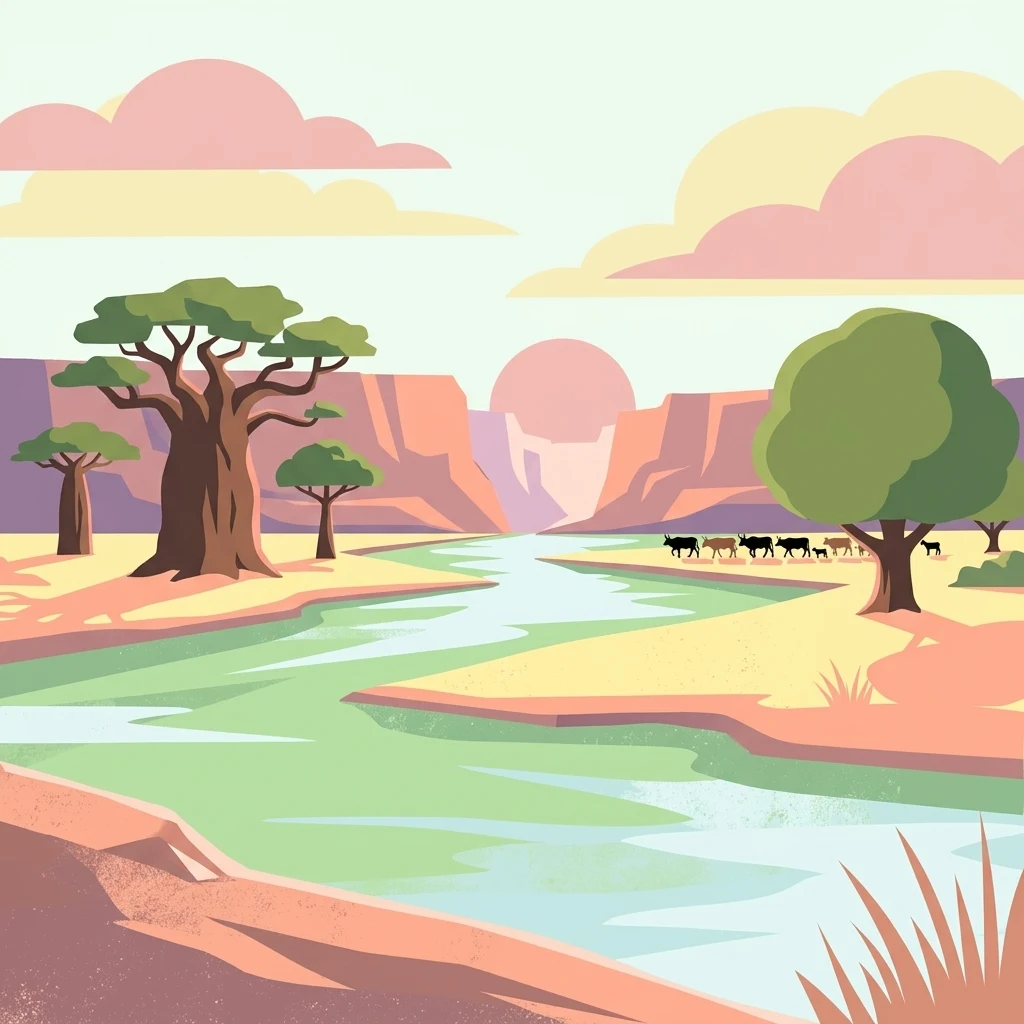
A flat-style digital illustration depicting a river flowing through a desert-like savanna landscape with baobab trees, rounded hills, and a small herd of cattle in the distance.

Madarounfa Lake

Nature reserve

Park overview

Structured park overview, official facts, and landscape profile for Madarounfa Lake

Madarounfa Lake park facts, protected area profile, and essential visitor context

Review the core facts for Madarounfa Lake, including designation, size, terrain, visitor scale, habitats, and operating context in one park-focused overview.

About Madarounfa Lake

Madarounfa Lake is a freshwater wetland in the commune of Madarounfa, in Niger's Maradi Region. It occupies a low point formed historically where the seasonal Goulbi de Gabi valley once met the Goulbi de Maradi, a process that produced the shallow basin the lake fills each year. Today the lake's surface oscillates dramatically with the seasons, swelling during the July and August rains and contracting through the long dry period, which shapes both its ecology and the rhythms of life around its shores.

The lake sits firmly within the climatic transition between the Sahel and the Sudanese zone. Annual rainfall in the surrounding area typically falls between 400 and 600 mm, and the vegetation reflects this intermediate position. Stands of Mitragyna inermis, Diospyros mespiliformis, Acacia albida, Hyphaene thebaica, and Piliostigma reticulatum line parts of the shoreline, creating a mixed woodland fringe that supports the lake's birdlife and contributes to its visual character against the broader semi-arid landscape.

Ecologically, the lake is among the most important wetlands in the Maradi Region. Its formal recognition as a Ramsar site in 2019 reflects its value for migratory and resident waterbirds, while its long history of use by local communities has made it a central node for fishing, irrigated cropping, and livestock watering. The lake's proximity to the town of Madarounfa, with more than 12,000 inhabitants, and to surrounding villages such as Saoulawa, Gamji, In Riadi, and Dan Toudoun Madarounfa, ties the site firmly into everyday regional life.

What makes Madarounfa Lake especially distinctive is the way ecology, hydrology, and cultural memory converge at a single place. The shoreline hosts the Tombs of the 99 Saints, an Islamic pilgrimage site whose origin story is interwoven with the lake itself, and the lake, the tombs, and the nearby protected forest have been proposed jointly for UNESCO World Heritage status. This layering of natural and cultural significance elevates Madarounfa Lake beyond a simple regional waterbody into a landscape of national and international interest.

Quick facts and research context for Madarounfa Lake

Madarounfa Lake is a seasonal freshwater body in southern Niger, located in the Maradi Region within the commune of Madarounfa. Its surface area fluctuates between roughly 400 and 850 hectares depending on rainfall, and maximum depth is estimated at about 5.5 meters. The lake sits in the transition zone between Sahel and Sudanese climate, receiving between 400 and 600 mm of rain annually, with peak water levels during the July and August rainy season.

Designated as a Ramsar wetland in December 2019, the lake anchors a 524.3-hectar protected area that combines aquatic habitat, fringing woodland, and a culturally important Islamic pilgrimage site. It also functions as a working landscape supporting local fisheries, irrigated fields, livestock, and domestic water needs for surrounding villages.

Protection and recognition

Documented terrestrial protection records and international recognition framework

Madarounfa Lake Protection Status and Designated Conservation Scope

Madarounfa Lake maintains a documented terrestrial protection scope without imported international recognition sources or transboundary status. Structured conservation records outline the official management framework and designated landscape boundaries.

Protection details

Protection scope
Terrestrial
Transboundary protection
No
Park context

Deeper park guide and search-rich context for Madarounfa Lake

Madarounfa Lake history, landscape, wildlife, and travel context

Explore Madarounfa Lake through its history, landscape character, ecosystems, wildlife, conservation priorities, cultural context, and seasonal travel timing in a structured park guide built for atlas discovery and search intent.

Why Madarounfa Lake stands out

Madarounfa Lake is best known for two intertwined identities: its ecological importance as a Ramsar-designated wetland supporting a rich bird community in the Sahel-Sudanese transition zone, and its cultural role as the setting of the Tombs of the 99 Saints, a recognized Islamic pilgrimage site. The combination of migratory waterbirds, fringing woodlands dominated by species such as Mitragyna inermis, and a sacred shoreline gives the lake a distinctive dual character that is unusual even within West African wetland systems. It is also recognized as one of the most important fishing waters in the Maradi Region, and as part of a three-component UNESCO tentative list entry that links the lake, the protected forest of Madarounfa, and the saints' tombs into a single cultural-natural landscape.
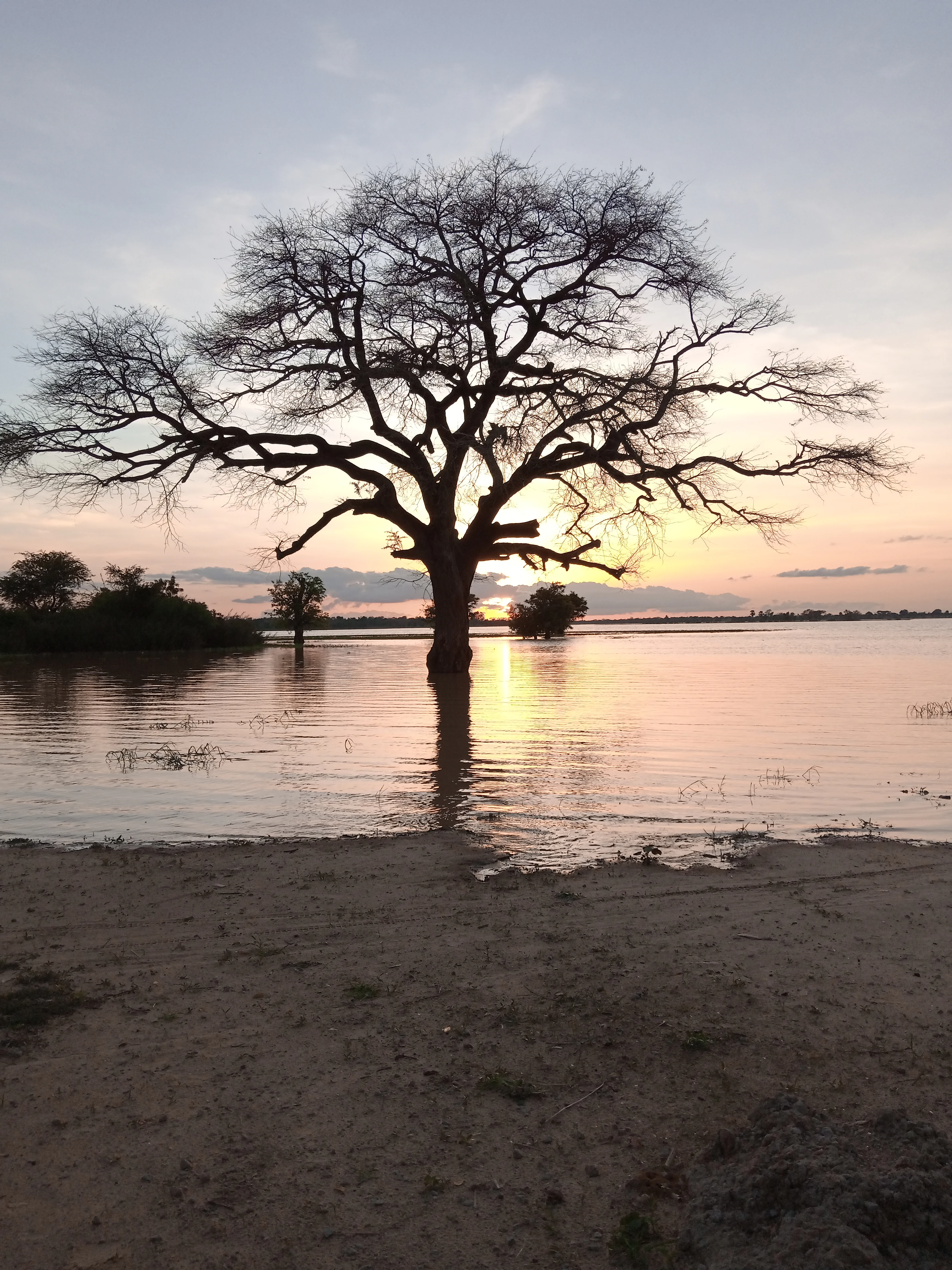
A large bare-branched tree stands in the middle of a calm, reflective lake during a sunset with warm, muted colors.
Sunset over the waters of Madarounfa Lake in Niger.

Madarounfa Lake history and protected-area timeline

Madarounfa Lake was not engineered; it formed naturally over time where the seasonal Goulbi de Gabi once joined the Goulbi de Maradi. The Maradi river built up a natural embankment, or shoreline ridge, that eventually trapped water behind it, creating the basin that now fills and empties with the seasons. This riverine origin continues to define the lake: the same Goulbis that helped form it still bring enormous quantities of sand, accelerating sedimentation and altering the lake's depth and ecology.

The lake's cultural history is at least as old as its hydrological history. According to local tradition, the pilgrimage site known as the Tombs of the 99 Saints was founded by three holy men who set out from Medina forty years after the death of the Prophet Mohammed. The founding narrative links the appearance of the lake itself to the search for water by a sacred young woman named Saâdatou, who asked Allah for help before prayer, and from whose plea the lake is said to have sprung. The site has long been associated with reported mysterious lights and spiritual phenomena, drawing pilgrims and giving the shoreline a deeper meaning than mere utility.

In the modern era, the lake's significance was elevated on May 26, 2006, when Niger's Ministry of Culture proposed the lake, the Tombs of the 99 Saints, and the Protected Forest of Madarounfa as a single nomination for inclusion on the UNESCO World Heritage Tentative List. This formal recognition of the combined cultural and natural value of the area was followed on December 18, 2019 by designation of the lake as a wetland of international importance under the Ramsar Convention, securing its status as both a regionally vital resource and an internationally acknowledged conservation site.

Madarounfa Lake landscape and geographic character

Madarounfa Lake is a shallow, open waterbody whose shape and extent shift noticeably through the year. During and immediately after the rainy season, the lake reaches its fullest extent; in drier months it contracts considerably, exposing marginal flats and altering the relationship between water, shore, and surrounding woodland. Maximum depth is estimated at about 5.5 meters, but most of the lake is considerably shallower, and the gradual infilling of sediment carried by the Goulbi de Gabi and the Madarounfa Canal continues to reshape its bathymetry over time.

The lake lies within a gently undulating semi-arid terrain typical of the Sahel-Sudanese transition. To the east, the urban center of Madarounfa rises with the compact character of a regional small town; to the south, west, and north, smaller villages punctuate the landscape. The lake's most expressive visual quality comes from the contrast between the open water and the wooded shoreline, particularly the stands of Mitragyna inermis and other fringing trees that soften the transition between aquatic and terrestrial environments.

A defining landscape feature is the dynamic interplay between the lake and its feeder rivers. The Goulbi de Gabi delivers seasonal pulses of water and sediment, while the Madarounfa Canal ordinarily drains the lake into the Goulbi de Maradi. When the Maradi river runs exceptionally high, the flow direction in the canal can reverse entirely, with the Goulbi de Maradi refilling the lake rather than draining it. This hydrological back-and-forth is as much a part of the landscape as the water itself, and ongoing sedimentation from both river systems is gradually transforming the lake into a shallower, more marsh-like system.
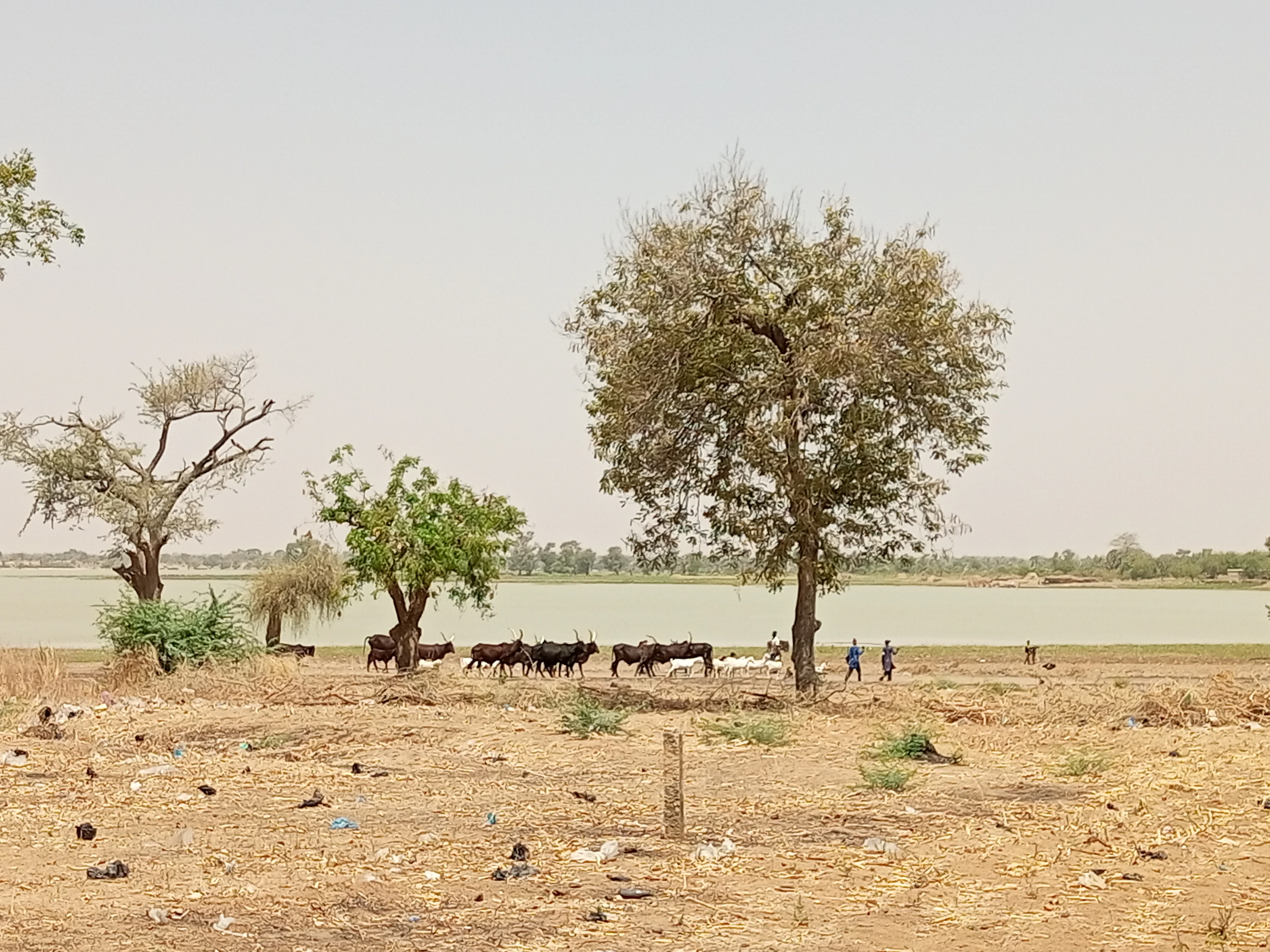
A dry, sparsely vegetated lakeshore in Niger with a herd of cattle and a few people near the water under a hazy sky.
A view of the shoreline at Madarounfa Lake, showing cattle grazing near the water.

Madarounfa Lake ecosystems, habitats, and plant life

Ecologically, Madarounfa Lake sits within a transition zone where Sahelian and Sudanese biomes overlap, giving it a richer mix of species than many purely Sahelian wetlands. The lake supports both resident and migratory waterbirds, with its seasonal fluctuations creating habitats that shift from open water to shallow margins and emergent vegetation, each of which suits different species at different times of year.

The lake is also defined by its riparian woodland. Mitragyna inermis is the most visually prominent tree along the shore, accompanied by Diospyros mespiliformis, Acacia albida, Hyphaene thebaica, and Piliostigma reticulatum. This mix produces a layered shoreline vegetation pattern that buffers the water, stabilizes banks, and provides nesting and roosting structure for birds as well as shade for fish and other aquatic life.

In hydrological terms, the lake is profoundly seasonal, and its ecology is organized around the annual rainfall cycle. The highest water levels generally arrive in July and August, after which the lake slowly recedes. The reversibility of flow in the Madarounfa Canal adds a further ecological dynamic: in some years the lake is a net outflow system, in others a net inflow system, and this variability influences nutrient cycling, sediment deposition, and breeding conditions for fish and birds. The result is a wetland whose ecological character is closely tracked to the rhythm of the regional climate.

Madarounfa Lake wildlife and species highlights

Madarounfa Lake is recognized above all for its birdlife. The combination of open water, shallow margins, and fringing woodland attracts a wide range of waterbirds, waders, raptors, doves, rollers, and passerines. Documented species include the Common Sandpiper, African Jacana, Grey Heron, Black-headed Heron, Purple Heron, Squacco Heron, White Stork, Black-winged Kite, Gabar Goshawk, Black Kite, and several species of starling, woodpecker, and weaver typical of the West African Sahel-Sudan transition.

Seasonal visitors add to the site's ornithological weight. Migratory species such as the Garganey, Ruff, Black-tailed Godwit, and Wood Sandpiper have been recorded, along with European passerines including the Common Redstart and the Northern Wheatear that pass through the region. Native resident species such as the White-faced Whistling Duck and the Spur-winged Goose contribute to the lake's year-round waterbird presence.

Beyond birds, the lake historically supported significant fish populations, and it remains one of the most important fisheries in the Maradi Region. However, the ongoing influx of sand from the Goulbi de Gabi and the Goulbi de Maradi has stressed certain species, notably the Nile Perch, whose populations have declined as the lake has become shallower and more sediment-laden. The lake's continued ecological value depends in part on how these sedimentation pressures are managed over time.

Madarounfa Lake conservation status and protection priorities

Madarounfa Lake's conservation profile rests on three pillars: international designation, ecological function, and cultural-religious significance. Its designation in December 2019 as a Ramsar wetland of international importance formally recognized the lake as a habitat of global value, particularly for its waterbird populations and its role within the Sahel-Sudanese transition zone.

Beyond the Ramsar designation, the lake forms part of a broader cultural-natural landscape recognized at the national level. In 2006, the Nigerien Ministry of Culture proposed the lake together with the Tombs of the 99 Saints and the adjacent Protected Forest of Madarounfa for inclusion on the UNESCO World Heritage Tentative List, treating them as a single integrated site of heritage value.

The lake is also under demonstrable environmental pressure. Heavy sediment loads from the Goulbi de Gabi and the Goulbi de Maradi are gradually silting the basin, affecting fisheries and potentially altering habitat structure for birds and other wildlife. Conservation of the lake in any meaningful sense will increasingly require attention to these upstream sediment dynamics, alongside the protection of its riparian woodland and its cultural shoreline.

Madarounfa Lake cultural meaning and human context

Cultural identity at Madarounfa Lake is inseparable from the Tombs of the 99 Saints, an Islamic pilgrimage site located along the shore and, in part, beneath the water. According to local tradition, the site was founded by three holy men who traveled from Medina forty years after the death of the Prophet Mohammed, and the lake itself is woven into the founding narrative through the story of Saâdatou, a sacred young woman sent to find water for ritual purification before prayer.

The site has long been associated with reports of mysterious lights and spiritual phenomena, and it continues to function as a destination for pilgrims and visitors. Together with the adjacent Protected Forest of Madarounfa, the tombs are formally linked to the lake in Niger's 2006 UNESCO tentative list proposal, framing the area as a combined cultural and natural heritage landscape rooted in both Islamic tradition and Sahelian ecology.

Everyday cultural life around the lake is shaped by the same shoreline. Residents of Madarounfa and surrounding villages use the lake for fishing, livestock watering, washing clothes, and irrigated agriculture, integrating the site into daily routines alongside its religious importance. This combination of sacred landscape and working wetland gives the lake a particularly layered cultural character.

Top sights and standout views in Madarounfa Lake

Madarounfa Lake is a Ramsar-designated wetland in Niger's Maradi Region, defined by the seasonal rise and fall of its waters and the seasonal character of its two feeder rivers. Its most distinctive quality is the way the shoreline combines riparian woodland, open water, and the pilgrimage site of the Tombs of the 99 Saints into a single cultural-ecological landscape.

The lake's importance is both regional and international. It is one of the most heavily used fishing waters in the Maradi Region and a vital resource for irrigated agriculture, livestock, and domestic use, while its formal recognition under the Ramsar Convention and its inclusion in a UNESCO tentative list nomination mark it as a place of broader significance.

Best time to visit Madarounfa Lake

The character of Madarounfa Lake shifts with the rainy season. Peak water levels typically arrive in July and August, when the Goulbi de Gabi delivers seasonal runoff and the lake reaches its fullest extent. This period offers the richest conditions for waterbird observation, broader open water, and a greener surrounding landscape, though it is also the time when access roads may be more difficult and temperatures are at their highest.

In the dry months that follow, the lake contracts, exposing margins and concentrating wildlife around the shrinking water. Cooler winter months bring a different atmosphere, with lower temperatures and a more pastoral rhythm of fishing and livestock activity along the shore. Each season offers a distinct experience of the lake, shaped by rainfall, runoff, and the migration patterns of the region's birds.
Monthly climate preview

Long term representative temperature and precipitation averages recorded across twelve months

Madarounfa Lake Climate Normals and Annual Weather Patterns

Historical climate records for Madarounfa Lake demonstrate distinct shifts in average monthly temperatures and precipitation rates across the representative coordinate. Examining the complete twelve month profile provides detailed context on long term thermal swings and rainfall distributions.
Annual mean28 °C
22 °C33 °C
Jan22°
Feb25°
Mar29°
Apr32°
May33°
Jun31°
Jul29°
Aug27°
Sep27°
Oct28°
Nov25°
Dec22°
Warmest month
May

32.9 °C

Coolest month
January

21.9 °C

Wettest month
August

6.4 mm/day

Driest month
January

0 mm/day

Park location guide

Geography guide, regional context, and park location map for Madarounfa Lake

Madarounfa Lake park geography, regions, and map view in Niger

Understand where Madarounfa Lake sits in Niger through a broader geographic reading of the surrounding landscape, nearby location context, and its mapped position within the national park landscape.

How Madarounfa Lake fits into Niger

Niger is a landlocked West African country spanning approximately 1.27 million km², making it the largest landlocked country in the region and the second-largest landlocked nation in Africa. Over 80% of its territory lies in the Sahara Desert, with the population concentrated in clusters in the southern and western regions. The country gained independence from France in 1960 and has experienced multiple coups, most recently in 2023.

Wider geography shaping Madarounfa Lake in Niger

Niger is located in West Africa and is landlocked, bordered by Libya (northeast), Chad (east), Nigeria (south), Benin and Burkina Faso (southwest), Mali (west), and Algeria (northwest). Over 80% of the country's land area lies in the Sahara Desert. The terrain is predominantly flat desert plains and sand dunes, with the Niger River flowing through the southwest corner near the capital Niamey.

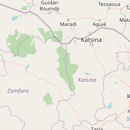
Map view of Madarounfa Lake

Use this park location map to pinpoint Madarounfa Lake in Niger, understand its exact geographic position, and read its mapped placement within the surrounding landscape more clearly.

Pigeon | © OpenStreetMap contributors

Location context for Madarounfa Lake

Maradi Region

Explore photographic views of open waters, seasonal shorelines, and riparian woodlands across the protected landscape.

Madarounfa Lake Photos and Landscape Scenery: Visualizing the Protected Wetland Environment

Visual records capture the shifting character of the shallow freshwater basin, revealing seasonal contrasts between open water and fringing woodlands. Examining these protected area photographs provides deeper insight into the delicate ecological balance defining the Sahel and Sudanese transition zone.

A large bare-branched tree stands in the middle of a calm, reflective lake during a sunset with warm, muted colors.

A wide shot of a lake shoreline in a dry region with sparse, low-growing trees standing near the water, surrounded by dry, cracked soil.

A dry, sparsely vegetated lakeshore in Niger with a herd of cattle and a few people near the water under a hazy sky.

Park atlas

Discover related wetland reserves and regional protected landscapes across the surrounding terrain.

Parks Near Madarounfa Lake and Other Protected Areas to Compare Next

Browse other parks near Madarounfa Lake to examine similar wetland habitats, seasonal waterways, and transition zone geography. Expanding the regional view helps place local conservation sites within a broader network of protected natural areas.
A soft, horizontal watercolor painting showing a green and tan landscape of trees and hills with a reflecting body of water in the foreground, set against a white background.
Nature reserveMaradi Region
About 3.8 km away#1 closest

North

Geschützter Wald von Madarounfa: Protected Woodland and Nature Reserve in the Maradi Region

Mapping the Sahel-Sudan transition landscapes of Niger.

Located in the Maradi Region, this nature reserve protects a rare mosaic of dryland vegetation, including acacia and tamarind groves on alluvial soils. The woodland functions as a critical environmental anchor within the surrounding agricultural plains, offering a window into the natural history of the Goulbi de Maradi river valley.

Area
8.3 km²
Established
1950
Relief
Lowland
Climate
Subtropical
Protected areaTahoua Region
About 209 km away#2 closest

Northwest

Mare de Tabalak Protected Area: Geography and Wetland Landscape in Tahoua, Niger

Mapping a unique Sahelian freshwater ecosystem and seasonal floodplains

Mare de Tabalak serves as one of the most ecologically significant wetlands in Niger. This protected area, characterized by its permanent freshwater lake and vast seasonal floodplains, sits at the intersection of the Ader Doutchi plateaus and the Tadrès sand dunes. The site acts as a major hub for migratory bird populations and supports essential regional pastoral and agricultural livelihoods within the Tahoua landscape.

Area
7 km²
Established
2005
Relief
Lowland
Climate
Arid
A horizontal watercolor painting depicting a soft green landscape with rolling hills in the background and marshy vegetation in the foreground.
Protected areaZinder
About 263 km away#3 closest

East

Guidimouni Lake Protected Area: Wetland Geography and Zinder Region Landscape Atlas

A Ramsar-designated freshwater and saline wetland system in the Sahel.

Guidimouni Lake is a significant endorheic wetland situated within the Zinder Region of Niger. This protected area consists of a long, narrow depression featuring a rare coexistence of fresh and saline water basins. Beyond its ecological role, the site provides a critical framework for understanding the interplay between Sahelian sand plains, local water-lily habitats, and the regional agro-pastoral economy.

Area
0.6 km²
Established
2019
Relief
Lowland
Climate
Subtropical
Wildlife reserveZinder
About 266 km away#4 closest

East

Mare de Lassouri Wildlife Reserve: Geographic Context and Sahel Wetland Mapping

Protecting vital aquatic habitats in the Zinder Region

Mare de Lassouri serves as a central hub for wetland conservation within the Zinder Region of Niger. This shallow freshwater basin offers a rich habitat mosaic where migratory waterbirds congregate amid bushy savanna, providing essential ecological value and sustaining local agricultural livelihoods in a resource-scarce Sahelian landscape.

Area
7.5 km²
Established
2005
Relief
Lowland
Climate
Arid
Protected areaTahoua Region
About 277 km away#5 closest

West

Mare de Dan Doutchi Protected Area: Mapping the Sahelian Wetlands of Tahoua Region

Permanent freshwater lake and Ramsar-listed ecological site

Situated in the Tahoua Region, Mare de Dan Doutchi acts as a rare permanent waterbody in the transition zone between the Sahel and the Sahara. This detailed profile covers the hydrological features of the basin, its role as a seasonal refuge for diverse bird species, and its importance to regional livelihoods within the Iullemmeden Basin context.

Area
382.5 km²
Established
1974
Relief
Lowland
Climate
Arid
National parkNigeria
About 292 km away#6 closest

South

Kamuku National Park: Nigeria's Protected Savanna Ecosystem and Inselberg Landscape

Explore mapped boundaries and regional geography.

Delve into Kamuku National Park, a significant protected savanna ecosystem in Nigeria, recognized for its unique geological features such as the Goron Dutse inselberg and the Dogon Ruwa Waterfalls. This page offers an atlas-level view of the park's landscape, detailing its protected area status, its role as elephant habitat, and its exceptional biodiversity, providing a comprehensive geographic context for exploration.

Area
1,120 km²
Established
1999
IUCN
II
Relief
Lowland
Wildlife reserveYobe
About 362 km away#7 closest

East

Nguru Lake Wildlife Reserve: Sahelian Wetland and Floodplain Geography

A protected freshwater ecosystem in Yobe, Nigeria

Nguru Lake serves as a vital hydrological anchor within the Hadejia-Nguru wetland system. This endorheic, shallow-water environment undergoes dramatic seasonal expansion, creating a rich mosaic of marshlands and mudflats. The site stands as a key protected area within the Chad Basin landscape, offering a unique look at Sahelian water ecology and floodplain dynamics.

Area
37 km²
Relief
Lowland
Climate
Tropical
Scope
Terrestrial
Protected areaDosso Region
About 365 km away#8 closest

West

Dallol Maouri Protected Area: Geographic Overview of Niger's Fossilized Wetland Valleys

Mapping seasonal pond systems and floodplain corridors in the Dosso Region

Dallol Maouri serves as a quintessential example of the ancient drainage systems found in the Iullemmeden Basin. As a Ramsar-listed protected area, it features a unique north to south orientation that fosters a rich transition between dryland Sahel and Sudanian savanna. The valley is defined by its seasonal mares, palm groves, and intricate network of koris tributaries that shape the geography of southwestern Niger.

Area
3,175.2 km²
Established
2004
Relief
Lowland
Climate
Subtropical

Common questions about visiting, size, designation, and location context for Madarounfa Lake

Madarounfa Lake FAQs for park facts, access, geography, and protected area context

Find quick answers about Madarounfa Lake, including protected-area facts, park geography, trail and visitor context, and how the park fits into its surrounding country and regional landscape.
MoriAtlas Explorer

Continue Your Protected Areas Search Across the Global Atlas

Deepen your exploration by continuing the structured search for national parks and protected areas worldwide. Utilize the comprehensive filtering capabilities to compare different conservation landscapes and refine your understanding of global park geography. Discover more about the distribution and characteristics of protected natural areas.

Global natural geography