Why Malampaya Sound Protected Landscape/Seascape stands out
The protected area is best known for its sheltered, island-divided embayment that mixes mangrove-lined shorelines with extensive tidal flats, and for its nutrient-rich brackish inner waters fed by numerous streams. It stands out among Philippine marine protected areas for the size of its brackish-water system, the rich plankton base that supports aquaculture, and the presence of small populations of the rare Irrawaddy dolphin and the eastern Pacific dolphin within its waters. It is also notable as a combined landscape and seascape reserve, where marine biodiversity, mangrove ecosystems, and the livelihoods of coastal fishing communities are managed together under one framework.

Malampaya Sound Protected Landscape/Seascape history and protected-area timeline
Malampaya Sound Protected Landscape/Seascape was officially established on 12 July 2000 when Presidential Proclamation 342 took effect. The designation recognized the ecological value of the bay and the immediate dependence of surrounding coastal communities on its marine resources. By creating a single, integrated protected area that combined landscape and seascape categories, the proclamation brought together mangrove forests, tidal flats, open marine waters, and inhabited coastline under a unified management framework.
Following its establishment, the protected area became a focus for sustainable fisheries development, particularly through aquaculture operations based in the brackish inner bay. Local planning efforts also connected the site to broader regional conservation strategies on Palawan, including adjacent reserves such as El Nido-Taytay. Over the following years, the area evolved into a working example of how Philippine protected-area law can address both biodiversity conservation and the economic needs of coastal populations simultaneously.
Malampaya Sound Protected Landscape/Seascape landscape and geographic character
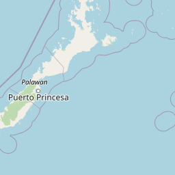
The defining feature of the protected area is the Malampaya Sound, an elongated bay on the northern coast of Palawan. The sound is split into two zones by a chain of thirteen smaller islands, creating a layered seascape of sheltered inner waters and more exposed outer waters. The islands themselves add topographic variety, forming a transitional belt between the two marine zones.
Along the shore, the landscape is shaped by extensive mangrove forests that fringe the coast and by broad intertidal mud and sand flats that are exposed during low tide. Inland from the bay, numerous small rivers and streams descend from the Palawan hinterland and discharge into the sound, feeding the brackish conditions of the inner bay. To the east lies Lake Manguao, an inland freshwater body, and to the north the terrain transitions toward the limestone-dominated landscapes of the El Nido-Taytay region.
Malampaya Sound Protected Landscape/Seascape ecosystems, habitats, and plant life
The Malampaya Sound ecosystem is defined by a layered transition between mangrove forest, intertidal flats, brackish estuarine waters, and open marine habitat. Mangroves anchor the coastline, providing nursery grounds for many fish species and stabilizing sediment along the bay's edge. The tidal flats extend the productive zone into the intertidal realm, where invertebrates and small fish thrive.
In the inner bay, the mixing of fresh water from inland streams with marine water creates a brackish environment with high concentrations of nutrients. Phytoplankton and zooplankton flourish in these conditions, forming the base of a food web that supports both wild fisheries and aquaculture. The outer zone of the sound remains more saline and open, completing the ecosystem gradient from sheltered estuary to deeper coastal water. As a combined landscape and seascape, the protected area links terrestrial and marine ecological processes into a continuous system.
Malampaya Sound Protected Landscape/Seascape wildlife and species highlights
Wildlife around Malampaya Sound centers on a diverse and productive fish community. Roughly 156 fish species have been recorded in the waters of the sound, and around 60 of these contribute directly to commercial fisheries. This richness reflects the combined influence of mangrove habitat, estuarine nutrients, and the gradient from brackish to more open water.
The sound also holds significance for marine mammals. Small populations of the rare Irrawaddy dolphin and the eastern Pacific dolphin occur in the area. Their presence elevates the conservation importance of the protected area beyond fisheries alone, drawing attention to the broader ecological health of the bay. Birdlife associated with mangroves and tidal flats is also a regular feature of the shoreline ecosystem, though specific bird records are not highlighted in available sources.
Malampaya Sound Protected Landscape/Seascape conservation status and protection priorities
Malampaya Sound Protected Landscape/Seascape was established in 2000 under Presidential Proclamation 342 to protect both marine and terrestrial ecosystems along Palawan's northern coast. The protected area's combined landscape and seascape designation formally recognizes that the mangrove forests, tidal flats, and bay waters function as an interconnected ecological system, requiring coordinated management rather than separate conservation approaches.
A core conservation aim is to maintain the high productivity of the inner bay, where nutrient-rich brackish waters support both natural fisheries and aquaculture operations tied to sustainable-use goals. By bringing the fishery sector within the protected-area framework, the reserve links biodiversity protection with the regulatory and developmental planning of coastal resources. Its position between El Nido-Taytay Managed Resource Protected Area and inland Lake Manguao also gives Malampaya Sound a strong role within Palawan's wider network of conservation sites, strengthening landscape connectivity across the northern part of the island.
Malampaya Sound Protected Landscape/Seascape cultural meaning and human context
The protected area supports a substantial coastal population living in 22 barangays, most belonging to the municipality of Taytay and a smaller number to San Vicente. Fishing and agriculture together supply roughly 70 percent of household income in these communities, tying local cultural and economic identity closely to the rhythms of the bay and its seasonal productivity.
The protected area's design reflects this strong human presence by incorporating livelihood sustainability as a central objective, alongside biodiversity protection. The promotion of orderly aquaculture and regional tourism is intended to create economic alternatives that are compatible with long-term conservation, embedding cultural and community interests directly within the reserve's mandate.
Top sights and standout views in Malampaya Sound Protected Landscape/Seascape
The Malampaya Sound's defining highlight is its two-part marine geography: a sheltered, brackish inner bay separated from the more open outer sound by a chain of thirteen islands. This layout, combined with mangrove-edged shores and broad tidal flats, produces one of Palawan's most productive estuarine-marine transition zones.
Equally notable is the protected area's role as a living conservation landscape, where rare marine mammals, a rich fish fauna, and the daily economic life of coastal barangays intersect within a single management framework.
Best time to visit Malampaya Sound Protected Landscape/Seascape
Seasonal conditions across the northern Palawan coast follow typical Philippine tropical patterns, with a drier period generally offering calmer sea conditions, clearer views over the sound, and more reliable access to coastal and marine areas. The wetter season brings heavier rains and rougher waters, which can reduce visibility and make boat-based exploration of the sound and its islands more difficult.
Wildlife observation, including opportunities to encounter dolphins, may be more rewarding in calmer marine conditions, although specific seasonal patterns of marine mammal occurrence are not documented in available sources. Most visits center on the coastal communities of Taytay and the marine zones that benefit from stable weather.