

Mori Atlas logo
Natural monumentMalenický pramen

Understanding the iron-rich spring, historic mining terrain, and forested valley ecosystems

Malenický pramen Natural Monument: Mapped Protected Landscapes and Regional Geography

(Přírodní památka Malenický pramen)

Malenický pramen is a protected natural monument located within the steep, canyon-like forests of the Plzeň-sever District in the Czech Republic. This site features an iron-rich spring that creates a sequence of vibrant, mineralized pools nestled within a landscape shaped by both historical pyrite mining and active ecological restoration. The surrounding terrain represents a complex mix of geologic layers and forest stands, offering a detailed perspective on how localized conservation preserves unique hydrological features and industrial heritage within a modern woodland environment.

natural monumentprotected areaspringiron-rich wateracidic waterpyrite shale
A flat-style digital illustration showing a forest with a waterfall cascading into a pool, framed by coniferous trees and mountains.

Malenický pramen

Natural monument

Park overview

Structured park overview, official facts, and landscape profile for Malenický pramen

Malenický pramen park facts, protected area profile, and essential visitor context

Review the core facts for Malenický pramen, including designation, size, terrain, visitor scale, habitats, and operating context in one park-focused overview.

About Malenický pramen

Malenický pramen is a very small but thematically rich natural monument in the Plzeň Region of western Bohemia. Protected since December 2010, it occupies just 0.17 hectares of formal protected area plus a surrounding buffer of about 0.42 hectares. The site is positioned about 1.5 kilometers southwest of the village of Dražeň, nestled in the steep, locally canyon-like valley of the Dražeňský potok, a stream that ultimately feeds into the Střela River.

The core of the protected area is a cascade-like spring complex, formed by five flowing basins (tůně) that step down the slope of the valley. The spring is fed by a shallow fracture aquifer developed through the weathering of pyrite-bearing shales; rainfall infiltrates along fault systems, becomes enriched with minerals underground, and resurfaces through these terraced pools. Because of contact with mineralized shales, the water is exceptionally rich in iron, which gives the outflow its characteristic orange-brown hue and a strongly acidic character (around pH 3.1).

Beyond the spring itself, the monument protects the surrounding forest and its associated biodiversity. The valley's inaccessible slopes and frequently waterlogged single track discourage intensive forestry, allowing a more natural forest structure to develop. Norway spruce dominates the canopy, but pine, alder, birch, and locally beech and oak add structural variety. Deadwood that remains in the valley supports a rich community of mosses, liverworts, and fungi, including several bracket fungi typical of old-growth conditions.

While the monument is highly compact, its character is shaped by deep historical layers: vitriol mining from the mid-19th century left both physical (terracing) and chemical (mineral enrichment) imprints that the current protection regime now builds upon rather than erasing. Today Malenický pramen is visited primarily by hikers and cyclists following the Ludvík Očenášek educational trail through the Malenické údolí, linking it to the broader cultural landscape of the Plasy area.

Quick facts and research context for Malenický pramen

Malenický pramen is a Czech natural monument (přírodní památka) declared on 23 December 2010 by the Plzeň Region authority and managed by the Regional Authority of the Plzeň Region. It lies in the Plzeň-sever district of the Plzeň Region, near the village of Dražeň, at elevations between roughly 434 and 448 meters.

The protected zone covers only about 0.17 hectares, with an additional protective buffer of around 0.42 hectares. The site protects a cascade-type spring of iron-rich groundwater and the terraced accumulations formed by historical pyrite-shale mining. It is located within the Bohemian Massif, in a narrow forested valley of the Dražeňský potok, and is classified as an IUCN Category IV habitat/species management area.

Protection and recognition

Documented terrestrial conservation history and designation details for Malenický pramen

Malenický pramen Protection Status and Designated Area Record

Malenický pramen holds an established terrestrial protection status dating from 2010 within national conservation inventories. Structured records assemble verified designation data and management scope to provide clear context for ongoing preservation efforts.

Protection details

Protection scope
Terrestrial
Designated year
2010
Transboundary protection
No
Park context

Deeper park guide and search-rich context for Malenický pramen

Malenický pramen history, landscape, wildlife, and travel context

Explore Malenický pramen through its history, landscape character, ecosystems, wildlife, conservation priorities, cultural context, and seasonal travel timing in a structured park guide built for atlas discovery and search intent.

Why Malenický pramen stands out

Malenický pramen is best known for its highly mineralized, iron-rich spring water and the distinctive terraced formations that emerged as a legacy of 19th-century pyrite-shale mining. The outflow creates a string of small pools with vivid orange-brown discoloration, set within a steep, almost canyon-like forested valley. The site is equally valued as a small-scale example of forest restoration on former industrial land, where conservation management now seeks to diversify the stand away from spruce monoculture toward a more natural mix of species and age classes.
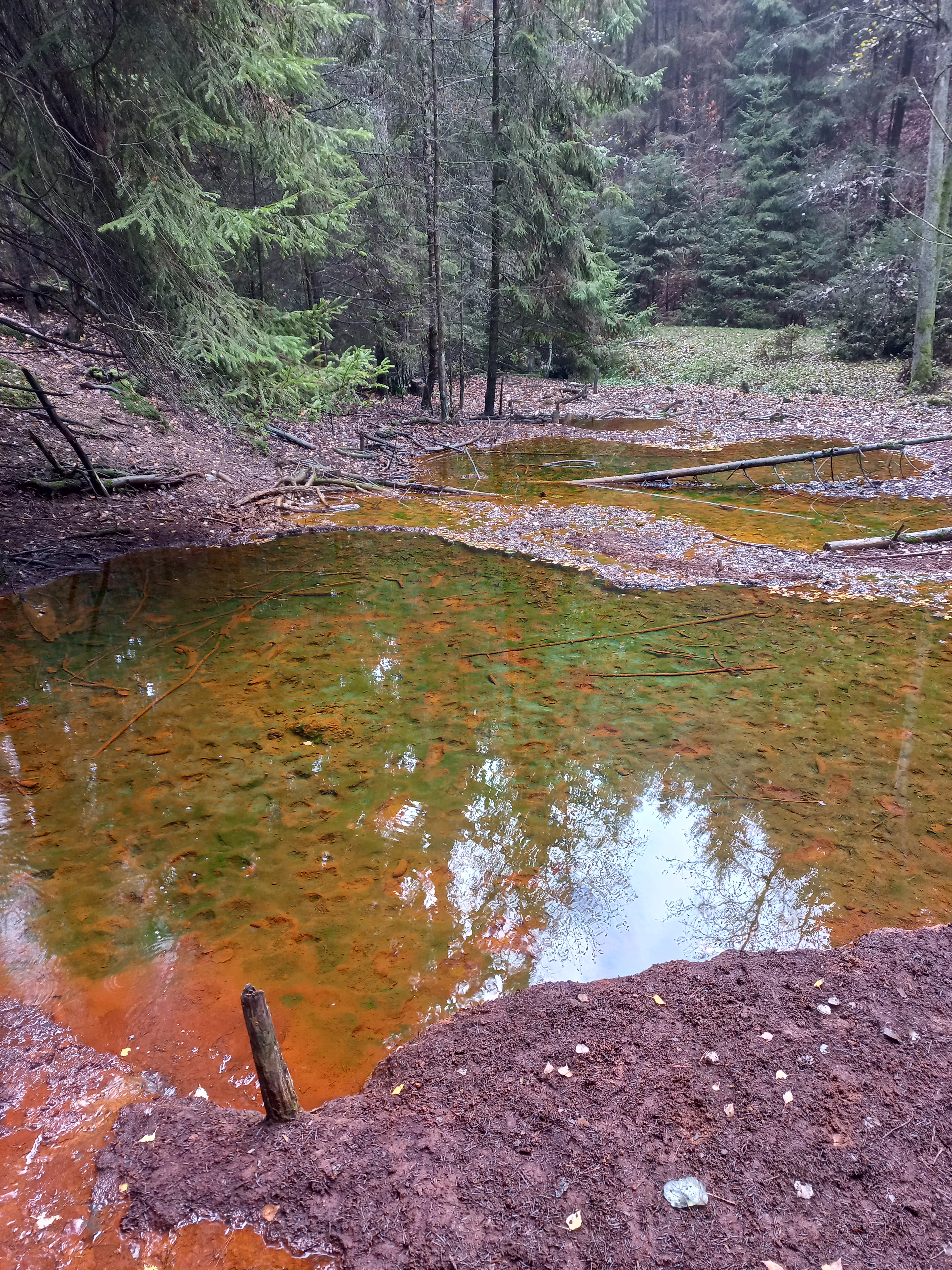
A view looking down at small, still pools of water with distinctive rust-colored mineral deposits on the bottom, surrounded by a forest of spruce trees and damp forest floor.
The iron-rich mineral pools of Malenický pramen spring.

Malenický pramen history and protected-area timeline

The protected area's history is closely tied to the industrial past of the Malenice area, even though the village's deeper origins remain undocumented. The earliest cartographic traces of the locality appear in records associated with the Third Military Survey, suggesting that the spot was already mapped as a recognizable site by the later 19th century.

In 1856 the firm of Johann David Starck opened the Frisch Glück (Jaré štěstí) mine at Malenice, initiating extraction of vitriol-rich shales. After rough sorting, the raw material was transported to Kaznějov, where it was processed into sulfuric acid in traditional lead chambers. Local mine water was also reportedly used in the preparation of façade paints, indicating a small but diverse industrial reuse of the site.

In the 19th century a cottage (čp. 32) was built at the site to house the mine supervisor; it is documented already on the stable-cadastre remapping of 1878. In 1888 a washery equipped with a water-powered stamp mill was added to the mine complex, where the extracted rock was crushed and sorted. Extraction, however, gradually became unprofitable and the mine was finally closed in the 1950s. With the death of the last mine supervisor in the 1970s, even the supervisor's cottage fell into ruin and disappeared from the landscape.

The full extent of mining is uncertain: historical documentation is lacking and modern surveys differ, with some sources citing a gallery length of 200 to 300 meters and others about 175 meters. A 2007 exploration by V. Forejt discovered a flooded entry at the end of the gallery, hinting that additional lower mining levels may exist. Today the gallery is completely flooded and mine water continues to emerge from its mouth, contributing to the spring system that the natural monument now protects. The formal designation of Malenický pramen as a přírodní památka (natural monument) was declared on 23 December 2010 by the Regional Authority of the Plzeň Region.

Malenický pramen landscape and geographic character

The protected area sits in a narrow, steeply incised section of the Malenické údolí, the forested valley of the Dražeňský potok. The valley descends sharply on both sides of the stream, creating an almost canyon-like character in places. The terrain transitions from plateau-like forest on the upper slopes down to a narrow floodplain along the stream.

The southern boundary of the protected site is formed by a forest track leading from the settlement of Lomany toward the solitary homestead of Chaloupky. The valley itself is dominated by the linear course of the stream, whose bed, side pools, and forested slopes collectively define the visual and ecological character of the site. The contrasting textures of steep rocky slopes, soft mossy banks, and persistent flowing water give the valley a layered, intimate quality despite its tiny protected core.

Geologically, the landscape belongs to the Bohemian Massif, specifically the Barrandien region. Its bedrock consists of Neoproterozoic chlorite-sericite phyllites alternating with greywackes and metamorphosed shales. Around the Malenice homestead, the phyllites are impregnated with pyrite in a roughly six-meter-thick ore-bearing layer, including both solid ore and so-called kanafas, an alternation of pyritic and barren bands. This ore-bearing stratum runs roughly northeast for about 1,400 meters and has been displaced by tectonic activity over geological time.

Malenický pramen ecosystems, habitats, and plant life

Malenický pramen protects a small but ecologically distinctive mosaic of stream-side forest, seepage springs, and deadwood habitats within the Malenické údolí. Because the protected zone is so small, its biotic communities are strongly influenced by the surrounding forest matrix, yet the valley's steep, inaccessible, and frequently waterlogged terrain produces local conditions quite different from nearby managed woodlands.

Spruce is the dominant tree, but the stand is more diverse than typical commercial forests in the region, with pines on dry steep slopes and alder and birch concentrated along the stream-side floodplain. To the right of the trail, older beech-oak stands further increase structural variety. Past spruce bark beetle outbreaks have begun to reduce the share of spruce in the canopy, opening space for natural regeneration.

The herb layer is comparatively sparse in the dense spruce sections but becomes richer near the stream, where spring-fed vegetation such as bittercress thrives alongside more common woodland forbs. Invasive plants, including Indian mock strawberry and common foxglove, are also present. The moist microclimate supports a well-developed moss and liverwort layer, particularly along banks and on fallen logs, where a noteworthy community of bracket and crust fungi colonizes deadwood.

Malenický pramen wildlife and species highlights

The fauna of Malenický pramen reflects the site's setting as a fragment of mature, structurally diverse forest within a broader plantation landscape. Birds typical of Czech woodlands dominate, including Eurasian nuthatch, goldcrest, common blackbird, mistle thrush, treecreeper, and Eurasian jay.

Of conservation interest, the large and powerful common raven occurs in the area as an endangered species at this scale, and the older forest condition provides habitat for the great spotted woodpecker. Among mammals, the invasive sika deer is notable; its browsing is reported to damage local forest regeneration and complicate the restoration of more natural species composition.

Malenický pramen conservation status and protection priorities

The conservation focus of Malenický pramen is twofold. The immediate priority is preserving the terraced spring and its mineral-rich hydrology, including the visible iron-stained outflow and the characteristic pool sequence. The longer-term management goal is to shift the local forest away from a spruce-dominated composition toward a more natural mix of tree species and age classes.

To support that shift, natural regeneration of native species is encouraged and selective thinning of spruce saplings has been carried out. Timber harvesting is limited to sanitation felling of bark-beetle-affected spruce, using low-impact techniques, and the area continues to be managed for hunting. As a přírodní památka, the site is classified at the international level as an IUCN Category IV protected area, recognizing its focus on habitat and species management on a small but ecologically meaningful footprint.

Malenický pramen cultural meaning and human context

The cultural context of Malenický pramen is inseparable from the industrial mining history of the Malenice valley. Although exact settlement dates are unknown, the area appears in the Third Military Survey and was already host to a substantial mid-19th-century mining operation, complete with a supervisor's cottage, washery, and water-driven stamp mill built in 1888.

The vitriol-rich shales were processed at Kaznějov into sulfuric acid, making the site a small node in 19th-century Bohemian chemical industry. Mine water was even reused locally in the production of façade paints. The valley's industrial buildings gradually disappeared after the mine closed in the 1950s, leaving only the submerged gallery and a few wall remnants visible today.

In the present day, the abandoned industrial landscape has been reframed through the Ludvík Očenášek educational trail, a 13-kilometer path with thirteen stops connecting Plasy and Dolní Bělá. Marked in green for tourist traffic, the trail weaves the heritage of mining together with the modern conservation story of the spring, the forest, and the broader Malenické údolí landscape.

Top sights and standout views in Malenický pramen

Among the standout features of Malenický pramen are the cascade of iron-rich spring pools, the vivid orange-brown coloration of the outflow, and the steep, almost canyon-like forest valley that frames the site. Its layered identity, combining 19th-century pyrite mining with modern forest restoration and deadwood biodiversity, gives it a depth unusual for a protected area of just 0.17 hectares.

The monument is also notable for the contrast between its small formal footprint and its wider landscape setting within the Malenické údolí, traversed by the Ludvík Očenášek educational trail that connects mining heritage, forest ecology, and the cultural landscape around Plasy.

Best time to visit Malenický pramen

Malenický pramen can be visited year-round, with access to the spring itself maintained in all seasons. Spring and early summer tend to bring the freshest green woodland conditions and the most active flow at the spring, while autumn highlights the forest's structural character with colorful foliage and abundant fungi on deadwood. Winter visits are feasible thanks to the regularly maintained trail and can offer a quieter, atmospheric view of the valley, though damp slopes and fallen logs are typical of the season. Because the site is small, the surrounding Malenické údolí and the educational trail provide the broader seasonal experience rather than any single iconic moment within the protected core.


Monthly climate preview

Long term monthly temperature and precipitation patterns recorded at representative park coordinates

Malenický pramen Climate Normals and Annual Temperature Rhythm

Representative coordinate measurements document measured monthly temperature swings and precipitation rates across the Malenický pramen landscape. Examining the complete twelve month climatology profile provides detailed insight into long term environmental rhythms.
Annual mean8 °C
-3 °C19 °C
Jan-3°
Feb-2°
Mar
Apr
May12°
Jun16°
Jul19°
Aug18°
Sep13°
Oct
Nov
Dec-2°
Warmest month
July

18.6 °C

Coolest month
January

-2.8 °C

Wettest month
June

2.5 mm/day

Driest month
February

1.2 mm/day

Park location guide

Geography guide, regional context, and park location map for Malenický pramen

Malenický pramen park geography, regions, and map view in Czechia

Understand where Malenický pramen sits in Czechia through a broader geographic reading of the surrounding landscape, nearby location context, and its mapped position within the national park landscape.

How Malenický pramen fits into Czechia

Czech Republic is a landlocked Central European country with a population of approximately 10.9 million people. The nation was established as an independent state on January 1, 1993, following the dissolution of Czechoslovakia. Its capital and largest city is Prague, with other major urban centers including Brno, Ostrava, Plzeň, and Liberec.

Wider geography shaping Malenický pramen in Czechia

The Czech Republic is a landlocked country in Central Europe. It is bordered by Germany to the west, Austria to the south, Poland to the northeast, and Slovakia to the southeast. The landscape is predominantly hilly, with the territory covering 78,871 square kilometers.

Map view of Malenický pramen

Use this park location map to pinpoint Malenický pramen in Czechia, understand its exact geographic position, and read its mapped placement within the surrounding landscape more clearly.

Pigeon | © OpenStreetMap contributors

Location context for Malenický pramen

Plzeň-sever District

Visual exploration of iron-rich mineral springs and forested valley terrain

Malenický Pramen Photos, Landscapes, and Protected Area Scenery

Visual records reveal the steep canyon-like forested valley and vivid iron-rich spring pools that characterize Malenický pramen. Photographic documentation helps visitors examine the intricate terrain, mixed forest stands, and unique hydrological formations across the protected natural monument.

A view looking down at small, still pools of water with distinctive rust-colored mineral deposits on the bottom, surrounded by a forest of spruce trees and damp forest floor.

A close-up view of a forest floor covered in fallen brown and yellow oak leaves, with patches of green moss and a prominent green fern frond.

Park atlas

Compare nearby regional protected areas and connected forest terrain in the surrounding district

Explore Other Parks Near Malenický Pramen and Surrounding Protected Landscapes

Continuing past Malenický pramen reveals additional protected areas and forested stream valleys across the surrounding region. Comparing adjacent natural monuments provides a broader geographic perspective on local geological formations and woodland conservation.
A soft, light watercolor illustration of a rocky outcrop surrounded by evergreen trees against a hazy, distant mountainous background.
Natural monumentPlzeňský kraj
About 16 km away#1 closest

South

Malesická skála Natural Monument and Geological Heritage in Plzeňský kraj

Protecting rare sedimentary rock formations and oak-pine forest habitats

Malesická skála serves as a significant geological reserve, protecting a unique elliptical rock pillar that reveals the history of Carboniferous stream currents. Visitors can study the complex surface textures formed by iron-bearing cementation, including dramatic rock caps and weathered ledge systems. The surrounding woodland, characterized by an oak-pine bilberry forest, provides an essential natural context for this rare Bohemian landmark.

Established
1974
IUCN
III
Relief
Upland
Climate
Temperate
A watercolor painting showing a river valley with coniferous trees, rocky riverbanks, and distant rolling hills in a soft, pastel palette.
Protected landscapeCzechia
About 17 km away#2 closest

North

Přírodní park Horní Střela: Protected Landscape and Geography in Czechia

Geological canyons and basalt uplands in western Bohemia

Přírodní park Horní Střela showcases a layered landscape shaped by the Střela River. The area features deep canyons, rocky slate slopes, and characteristic basalt-topped summits that create a diverse ecological mosaic within the Czech landscape.

Area
99.92 km²
Established
1978
Relief
Upland
Climate
Temperate
A minimalist watercolor painting depicting a winding river through green rolling hills and meadows on a white background.
Protected landscapePlzeňský kraj
About 17 km away#3 closest

East

Přírodní park Berounka: Protected Landscape Mapping and Geography in Plzeňský kraj

Western Bohemia river canyon and protected corridor

Přírodní park Berounka defines a large, unified protected landscape following the upper course of the Berounka River. The area encompasses dramatic valley scenery, including steep cliff sections, wooded slopes, and a mosaic of fields and historic villages throughout the Plzeňský kraj. Gain insight into the regional geography and the network of connected nature reserves that define this distinctive Bohemian river corridor.

Area
131 km²
Established
2021
Relief
Upland
Water
Major water bodies
Natural monumentPlzen Region
About 18 km away#4 closest

Southeast

Malochova skalka Natural Monument: Geographic Profile and Protected Landscape Identity

Unique spilite rock formations in the Plzen Region

Located in the Plzen Region, Malochova skalka is a protected natural monument defined by steep spilite cliffs and rare botanical assemblages. This site offers insight into the complex interaction between volcanic-derived bedrock, river valley topography, and oak-hornbeam forest, serving as a concentrated example of the varied natural terrain found throughout this section of the Czech Republic.

Area
0.015 km²
Established
1970
IUCN
IV
Relief
Upland
A soft watercolor painting of a rolling, hilly landscape with hints of forest, rendered in muted green, pink, and yellow tones on a white background.
Natural monumentCentral Bohemia Region
About 25 km away#5 closest

Northeast

Malý Uran Natural Monument: Protected Rocky Valley Slopes in the Central Bohemia Region

Geological and Botanical Conservation Area

Malý Uran represents a compact but significant natural monument defined by its steep valley slopes and Precambrian bedrock. The site protects a localized juniper habitat flourishing on skeletal soils above the Kosobodský stream, providing a clear example of how rare geological substrates influence regional plant life and landscape structure.

Area
0.159 km²
Established
1996
IUCN
IV
Water
Minor water
Natural monumentKarlovy Vary District
About 28 km away#6 closest

North

Valečské sklepy Natural Monument and Protected Bat Hibernation Site in Karlovy Vary

Volcanic terrain and critical wildlife infrastructure in western Bohemia

Valečské sklepy represents a unique form of protected landscape in the Karlovy Vary District, where historical underground cellars function as a specialized natural monument. The site maintains a crucial role as a winter hibernation refuge for the critically endangered western barbastelle, embedded within the volcanic geomorphology of the Doupovské hory region.

Established
2016
IUCN
III
Relief
Mountain
Climate
Temperate
A watercolor illustration of a rolling, green landscape with distant, faint hills and small ponds or water bodies in the foreground.
Natural monumentPlzeňský kraj
About 29 km away#7 closest

Southeast

Rokycanská stráň Natural Monument: Geological Exposures and Regional Protected Landscapes

Stratigraphic reference site in the Plzeňský kraj, Czech Republic

Rokycanská stráň represents a key geological protected area situated on the outskirts of Rokycany. The site protects the Klabava Formation stratotype and fossil-rich shales, functioning as a benchmark for Ordovician geology in the Barrandian area. Its four distinct parcels illustrate the interface between urban development and important paleontological research sites in the Plzeň region.

Area
0.208 km²
Established
1981
IUCN
IV
Relief
Upland
Natural monumentKarlovarský kraj
About 30 km away#8 closest

North

Valeč Natural Monument: Geologic and Ecological Landscapes in the Karlovarský kraj

Tracing volcanic terrain and fossil sites in the Doupovské Hory

Valeč Natural Monument offers a deep look into the volcanic geology and protected wilderness of western Bohemia. Known for its historical paleontological finds and diverse forest cover, this landscape provides an essential case study for mineralogical research and habitat preservation within the wider regional geography.

Area
5.436 km²
Established
1992
IUCN
IV
Relief
Mountain

Common questions about visiting, size, designation, and location context for Malenický pramen

Malenický pramen FAQs for park facts, access, geography, and protected area context

Find quick answers about Malenický pramen, including protected-area facts, park geography, trail and visitor context, and how the park fits into its surrounding country and regional landscape.
MoriAtlas Explorer

Continue Your Protected Areas Search Across the Global Atlas

Deepen your exploration by continuing the structured search for national parks and protected areas worldwide. Utilize the comprehensive filtering capabilities to compare different conservation landscapes and refine your understanding of global park geography. Discover more about the distribution and characteristics of protected natural areas.

Global natural geography