
Mori Atlas logo
Natural monumentMalesická skála

Examining the sedimentary rock tower, iron-rich concretions, and layered sandstone formations

Malesická skála Natural Monument: A Geological Landmark in the Heart of Plzeňský kraj

Malesická skála represents a compact geological treasure within the Plzeňský kraj region of the Czech Republic. This natural monument protects an imposing twenty-meter-tall sandstone tower that serves as a chronological record of Late Carboniferous river sediments. The site offers an intimate look at how varying water currents and iron-rich cementation created a distinct landscape of weathered ledges, rock caps, and vertical sedimentary bands.

natural monumentgeological reserveCarboniferous sandstonerock towerconglomerate outcropironstone concretions
A stylized flat-design illustration showing a central rocky outcrop, surrounding pine trees, a winding path, and a distant waterfall.

Malesická skála

Natural monument

Park overview

Structured park overview, official facts, and landscape profile for Malesická skála

Malesická skála park facts, protected area profile, and essential visitor context

Review the core facts for Malesická skála, including designation, size, terrain, visitor scale, habitats, and operating context in one park-focused overview.

About Malesická skála

Malesická skála belongs to a family of small, geologically focused natural monuments scattered across the Plzeň Region of western Bohemia. Although it is far smaller than any national park or large-scale protected landscape, and covers only a tiny footprint of land, it draws protection because it concentrates into a single outcrop a clear, readable record of an ancient river environment. The rock tower it preserves belongs to the Týnecké souvrství, the local name for the upper part of the Plzeň Basin sedimentary sequence, and offers one of the most accessible exposures of this unit in the immediate vicinity of Plzeň.

The site's broader landscape context is the Plaská pahorkatina, a gently rolling highland of mixed forest, farmland, and small stream valleys, with the Malesický potok cutting a tucked, asymmetrical little gorge into the surrounding terrain. Here the right bank rises only a few meters while the left bank climbs steeply to around twenty meters, and from that high wall the protected rock tower detaches itself almost like an egg-shaped tooth of stone. The surrounding forest is dominated by oak and pine with a bilberry understory, reflecting the dry, sandy, acidic soils that develop on the Carboniferous substrate.

What gives the site its deeper scientific identity is not size but clarity. The sequence of conglomerates and arkoses, each layer only a few decimeters thick, demonstrates how the Carboniferous river repeatedly shifted between higher and lower energy states, reworking its sediments and creating beds of differing resistance. Subsequent groundwater infiltration introduced iron-rich solutions that cemented portions of the rock into ferruginous concretions. Erosion over the intervening hundreds of millions of years stripped away the softer surroundings, leaving behind this compact upright tower where the relative strengths of each ancient layer are still directly observable.

Although the area is too small to support major infrastructure for visitors, the rock face has long been used as a minor climbing venue, and recreational pressure on the surface is visible where climbers and hikers have broken off iron-cemented ledges and crumbled softer conglomerate layers.

Quick facts and research context for Malesická skála

Malesická skála is a Czech natural monument (přírodní památka) of IUCN category III, situated in the Plzeň-město district within the cadastral area of Malesice. It was first protected in 1974 and re-declared under current legislation in 2009 by the Plzeň Region authority, and is recorded under number 611 in the Central List of Nature Conservation.

The protected zone itself covers about 0.03 hectares; an outer protective belt extends the managed area to roughly 0.34 hectares. The site lies between 367 and 376 meters above sea level in the Plaská pahorkatina highland. The rock tower itself is an isolated Carboniferous river-deposit feature protruding from the steep left bank of the Malesický potok valley, surrounded by oak-pine bilberry woodland.

Protection and recognition

Terrestrial protection records and historical designation data for Malesická skála

Malesická skála Protection Status and Designated Area History

Malesická skála maintains documented terrestrial protection status established under 2009 designation records. Official conservation history and management scope details are compiled directly from verified administrative sources.

Protection details

Protection scope
Terrestrial
Designated year
2009
Transboundary protection
No
Buffer area
0 km²
Park context

Deeper park guide and search-rich context for Malesická skála

Malesická skála history, landscape, wildlife, and travel context

Explore Malesická skála through its history, landscape character, ecosystems, wildlife, conservation priorities, cultural context, and seasonal travel timing in a structured park guide built for atlas discovery and search intent.

Why Malesická skála stands out

Malesická skála is best known as a miniature geological showcase of the Late Carboniferous "Týnec formation," where conglomerate and sandy arkose layers of an ancient river system are exposed in a single, free-standing rock tower roughly seven by fifteen meters across and some twenty meters tall. The varying resistance of these layers to weathering, combined with iron hydroxide cementation that hardened parts of the rock body, has produced a richly textured surface of pits, knobs, ledges, and the early stages of a capping "lid" of more resistant rock. This rare local feature makes the site a textbook example of how a Carbon-age river current, varying in speed and carrying power, is still readable in a present-day cliff face.
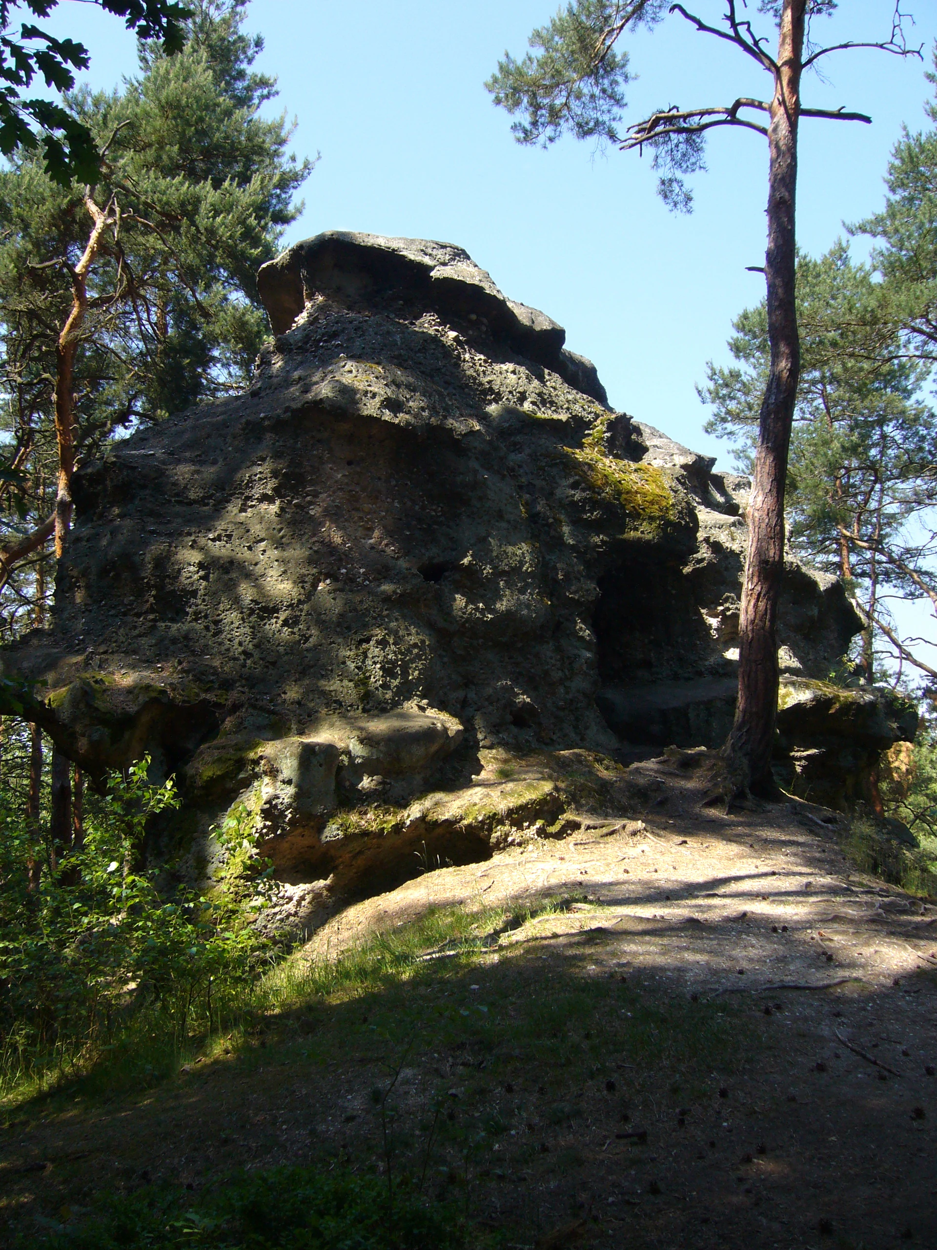
A large, weathered sandstone rock tower with an irregular, pitted surface, surrounded by pine trees on a sunny day.
A view of the distinctive Malesická skála rock formation, a natural monument known for its unique sedimentary geology.

Malesická skála history and protected-area timeline

Malesická skála is a small natural reserve whose own land surface was likely never cultivated or cleared, although the surrounding forest shows the long imprint of forestry and possibly historical forest grazing. The rock face itself has been used by climbers both before and after legal protection was introduced.

Formal protection began on 12 July 1974, when the district national committee (okresní národní výbor) of Plzeň-sever declared the site as a "chráněný přírodní výtvor," or protected natural monument, the category then used in Czechoslovakia. Following the reorganization of nature conservation in the Czech Republic, the site was re-declared on 6 October 2009 by the Regional Authority of the Plzeň Region under its present category of přírodní památka, or natural monument. In the Ústřední seznam ochrany přírody (Central List of Nature Conservation), it is registered under the code 611.

Malesická skála landscape and geographic character

The landscape around Malesická skála is shaped by the asymmetrical valley of the Malesický potok, a left-bank tributary of the Mže river flowing onward through the Berounka basin network. On one side the valley wall rises only a few meters above the stream; on the opposite, the left bank rises to roughly twenty meters, and from a bend in this slope the protected tower emerges.

The broader terrain belongs to the Plaská pahorkatina, specifically the Kaznějovská pahorkatina sub-unit and the Hornobřízská pahorkatina geomorphological district. This is a gently undulating Bohemian highland of mixed woodland, agricultural plots, and modest stream valleys. Locally, however, the micro-topography around the tower itself is dramatic in miniature: a steep lower slope gives way to a sharply inclined upper face, with the elliptical rock pillar jutting outward.

The Carboniferous geological materials of the area produce acidic, well-drained soils, here classified largely as typical and locally rubefied cambisols, supporting dry oak-pine forests with a bilberry understory rather than lush deciduous woodland. The overall impression of the site is therefore one of a warm, slightly acidic, midland environment in which an unusually durable and compact sandstone-conglomerate remnant acts as a rocky landmark above a quiet stream.

Malesická skála ecosystems, habitats, and plant life

Ecologically, Malesická skála is not a biodiversity hotspot or a species-rich habitat reserve. The declared object of protection is exclusively the geological exposure; no inventory survey of flora or fauna was conducted at the site. The surrounding woodland is oak-bor with bilberry (dubový bor borůvkový), a vegetation type characteristic of warm, dry, acidic soils over sandstone.

Nationally, this is a typical central-Bohemian forest community found on leached, sandy substrates derived from the local Carboniferous sediments, reflecting long-term forest management rather than natural primary vegetation. The greatest ecological value of the reserve lies less in rare species and more in preserving a wholly undisturbed rock face and the dry, structurally interesting outcrops and crevices that such a tower provides for mosses, lichens, and the small fauna of rock-inhabiting invertebrates.

The site lies within the catchment of the Malesický potok and ultimately of the Berounka river, occupying a gently warm climatic region with mean January temperatures around minus three to minus four degrees Celsius and mean July temperatures of fifteen to sixteen degrees Celsius under modern climatological normals.

Malesická skála conservation status and protection priorities

The conservation significance of Malesická skála is strictly geological. The Czech system of nature protection uses the category přírodní památka (natural monument) for specific, relatively small features of scientific, educational, or aesthetic interest, and this site fits that profile by preserving a single Carboniferous sandstone-conglomerate rock tower representative of the Týnecké souvrství formation.

By sheltering this outcrop from quarrying, collection, and large-scale disturbance, the protection ensures that a vivid textural and structural record of Late Carboniferous river deposition remains readable in cross-section. The reinforces-cemented iron oxide and hydroxide bands (ironstones, locally called "železivce"), the sequence of conglomerate and arkose beds, and the early form of a rock-cap "lid" at the summit are all preserved as a continuous natural reference section for the local geology.

The site's IUCN Category III designation places it alongside comparable national natural monuments whose values are essentially scientific and educational rather than ecological. The outer protective (buffer) zone, although tiny, helps limit casual damage to the immediate rock face.

Malesická skála cultural meaning and human context

The cultural dimension of Malesická skála is modest but locally meaningful. The site lies in the wooded outskirts of Plzeň, in the cadastral area of Malesice, a village that was absorbed into the city of Plzeň as part of its Plzeň 9 district. The external reserve touches rural Bohemian traditions in subtle ways: the surrounding woodland carries the long imprint of historic forestry management and possibly past forest grazing, rather than of agricultural clearance.

Locally, the rock tower has long been known as a small but respected climbing objective, and the visible damage to its surface, where climbing activity and visitor footfall have broken off cemented iron-bearing ledges and crumbled softer conglomerate bands, is itself a record of the site's recreational use. The yellow-marked Czech hiking trail linking Malesice with the neighboring village of Chotíkov passes directly by the site, integrating it into the everyday outdoor life of the suburban Plzeň landscape.

Top sights and standout views in Malesická skála

Malesická skála offers a number of distinctive points of interest despite its very small size. Chief among them is the compact elliptical rock tower itself, easily viewed from the nearby yellow hiking trail, whose exposed face reveals alternating conglomerate and arkose layers each only a few decimeters thick.

Equally notable are the iron hydroxide cementation bands that have hardened parts of the original sediment into ferruginous concretions, producing the pock-marks, knobs, and shelf-like ledges that texturize the present surface. The summit of the tower shows the very early stage of a "poklička," a cap of more resistant rock that protects a softer base; this geological curiosity is a classic feature of the broader sandstone landscapes of western Bohemia.

Finally, the surrounding oak-pine bilberry forest and the quiet, asymmetrical gorge of the Malesický potok provide an atmospheric, easily accessible framing for visitors approaching from Plzeň, making the site both a scientific reference point and a small but rewarding local nature stop.

Best time to visit Malesická skála

Malesická skála can be visited year-round as part of a short walk along the yellow-marked trail from Malesice toward Chotíkov; the site is small and does not involve challenging terrain. Late spring through early autumn tends to offer the most comfortable conditions, with longer daylight, dry footing on the slopes around the tower, and the bilberry layer under the oak-pine canopy fully green and easy to see.

In winter the rock face and surrounding slopes may be slippery and the climbable surface icy, while in early summer the closed canopy can make the gorge feel cooler and damper. Because the reservation is so small, there is no seasonal access closure; the practical variation is one of personal comfort and the visibility of geological features, which tend to look at their sharpest when the surface is dry and when low-angle light throws the tiny ledges and pits into relief.


Monthly climate preview

Long-term temperature and monthly precipitation patterns sampled at 493.8 meters elevation

Malesická skála Climate Normals and Annual Weather by Month

Historical data records mean temperatures ranging from negative 2.81 degrees Celsius to 18.63 degrees Celsius alongside daily precipitation between 1.17 and 2.52 millimeters across the twelve-month cycle. Reviewing the complete monthly profile provides deeper insight into long-term meteorological trends measured at this representative park coordinate.
Annual mean8 °C
-3 °C19 °C
Jan-3°
Feb-2°
Mar
Apr
May12°
Jun16°
Jul19°
Aug18°
Sep13°
Oct
Nov
Dec-2°
Warmest month
July

18.6 °C

Coolest month
January

-2.8 °C

Wettest month
June

2.5 mm/day

Driest month
February

1.2 mm/day

Park location guide

Geography guide, regional context, and park location map for Malesická skála

Malesická skála park geography, regions, and map view in Czechia

Understand where Malesická skála sits in Czechia through a broader geographic reading of the surrounding landscape, nearby location context, and its mapped position within the national park landscape.

How Malesická skála fits into Czechia

Czech Republic is a landlocked Central European country with a population of approximately 10.9 million people. The nation was established as an independent state on January 1, 1993, following the dissolution of Czechoslovakia. Its capital and largest city is Prague, with other major urban centers including Brno, Ostrava, Plzeň, and Liberec.

Wider geography shaping Malesická skála in Czechia

The Czech Republic is a landlocked country in Central Europe. It is bordered by Germany to the west, Austria to the south, Poland to the northeast, and Slovakia to the southeast. The landscape is predominantly hilly, with the territory covering 78,871 square kilometers.

Map view of Malesická skála

Use this park location map to pinpoint Malesická skála in Czechia, understand its exact geographic position, and read its mapped placement within the surrounding landscape more clearly.

Pigeon | © OpenStreetMap contributors

Location context for Malesická skála

Plzeňský kraj

Explore detailed imagery of the protected sandstone tower, forest terrain, and geological formations.

Malesická skála Photos and Scenery: Visualizing the Carboniferous Rock Tower

Visual records capture the distinctive sandstone formations, pock-marked rock faces, and surrounding oak-pine forest habitats of Malesická skála. Examining these detailed photographs helps researchers and visitors analyze the unique geological topography and protected landscape characteristics more effectively.

A large, weathered sandstone rock tower with an irregular, pitted surface, surrounded by pine trees on a sunny day.

Park atlas

Compare regional geology, stream valleys, and connected protected landscapes across western Bohemia

Exploring Parks Near Malesická Skála and Surrounding Bohemian Highland Protected Areas

Browsing other protected areas near Malesická skála reveals wider geological patterns across the Plzeň region and surrounding Bohemian highland terrain. Comparing these nearby natural monuments provides deeper context on sedimentary formations, local river valleys, and regional conservation geography.
Natural monumentPlzen Region
About 8.8 km away#1 closest

East

Malochova skalka Natural Monument: Geographic Profile and Protected Landscape Identity

Unique spilite rock formations in the Plzen Region

Located in the Plzen Region, Malochova skalka is a protected natural monument defined by steep spilite cliffs and rare botanical assemblages. This site offers insight into the complex interaction between volcanic-derived bedrock, river valley topography, and oak-hornbeam forest, serving as a concentrated example of the varied natural terrain found throughout this section of the Czech Republic.

Area
0.015 km²
Established
1970
IUCN
IV
Relief
Upland
A pale, soft watercolor illustration of a green meadow, a winding stream, and gentle, hazy rolling hills in the background.
Natural monumentPlzeň-sever District
About 16 km away#2 closest

North

Malenický pramen: Protected Natural Monument, Mining History, and Forest Geography

A study in mineral-rich hydrology and forested valley restoration

Located in the Plzeň-sever District, Malenický pramen is a site where geology and history intersect to create a distinctive protected habitat. The monument protects an iron-rich spring flowing through a steep forested valley, revealing traces of 19th-century pyrite mining. Its small, layered landscape serves as a focal point for understanding how mining heritage and forest ecology coexist within the broader framework of the Bohemian Massif's natural terrain.

Area
0.002 km²
Established
2010
IUCN
IV
Relief
Upland
A minimalist watercolor painting depicting a winding river through green rolling hills and meadows on a white background.
Protected landscapePlzeňský kraj
About 20 km away#3 closest

Northeast

Přírodní park Berounka: Protected Landscape Mapping and Geography in Plzeňský kraj

Western Bohemia river canyon and protected corridor

Přírodní park Berounka defines a large, unified protected landscape following the upper course of the Berounka River. The area encompasses dramatic valley scenery, including steep cliff sections, wooded slopes, and a mosaic of fields and historic villages throughout the Plzeňský kraj. Gain insight into the regional geography and the network of connected nature reserves that define this distinctive Bohemian river corridor.

Area
131 km²
Established
2021
Relief
Upland
Water
Major water bodies
A watercolor illustration of a rolling, green landscape with distant, faint hills and small ponds or water bodies in the foreground.
Natural monumentPlzeňský kraj
About 20 km away#4 closest

East

Rokycanská stráň Natural Monument: Geological Exposures and Regional Protected Landscapes

Stratigraphic reference site in the Plzeňský kraj, Czech Republic

Rokycanská stráň represents a key geological protected area situated on the outskirts of Rokycany. The site protects the Klabava Formation stratotype and fossil-rich shales, functioning as a benchmark for Ordovician geology in the Barrandian area. Its four distinct parcels illustrate the interface between urban development and important paleontological research sites in the Plzeň region.

Area
0.208 km²
Established
1981
IUCN
IV
Relief
Upland
A horizontal watercolor painting showing rolling green hills, scattered trees, and soft mountain silhouettes in the distance against a white background.
Protected landscapePlzeňský kraj
About 33 km away#5 closest

Southeast

Přírodní park Buková hora, Chýlava: Geographic Atlas and Protected Landscape Overview

Forested uplands and industrial heritage in western Bohemia.

Focusing on the 28 square kilometer expanse of Přírodní park Buková hora, Chýlava, this overview details the park's acidophilous oak forests, sedimentary bedrock, and inclusion of the Chejlava National Nature Reserve. Understand the site's role as a protected upland framed by the Úslava watershed and historic mining settlements in the Plzeňský kraj region.

Area
28 km²
Established
1983
Relief
Upland
Climate
Temperate
A watercolor painting showing a river valley with coniferous trees, rocky riverbanks, and distant rolling hills in a soft, pastel palette.
Protected landscapeCzechia
About 33 km away#6 closest

North

Přírodní park Horní Střela: Protected Landscape and Geography in Czechia

Geological canyons and basalt uplands in western Bohemia

Přírodní park Horní Střela showcases a layered landscape shaped by the Střela River. The area features deep canyons, rocky slate slopes, and characteristic basalt-topped summits that create a diverse ecological mosaic within the Czech landscape.

Area
99.92 km²
Established
1978
Relief
Upland
Climate
Temperate
A soft watercolor painting of a rolling, hilly landscape with hints of forest, rendered in muted green, pink, and yellow tones on a white background.
Natural monumentCentral Bohemia Region
About 39 km away#7 closest

Northeast

Malý Uran Natural Monument: Protected Rocky Valley Slopes in the Central Bohemia Region

Geological and Botanical Conservation Area

Malý Uran represents a compact but significant natural monument defined by its steep valley slopes and Precambrian bedrock. The site protects a localized juniper habitat flourishing on skeletal soils above the Kosobodský stream, providing a clear example of how rare geological substrates influence regional plant life and landscape structure.

Area
0.159 km²
Established
1996
IUCN
IV
Water
Minor water
A wide watercolor illustration showing a winding river, a line of green trees, and soft rolling hills in pastel green, pink, and purple tones against a white background.
Natural monumentStředočeský kraj
About 39 km away#8 closest

Northeast

Skryjsko-týřovické kambrium: A Scientific Natural Monument and Geological Landmark

Paleontological heritage in the central Bohemian hills.

Skryjsko-týřovické kambrium provides essential protection for fossil-bearing Cambrian strata in the Czech Republic. This landmark, managed as a natural monument within the Středočeský kraj, remains a foundational reference site for international researchers exploring early Paleozoic marine life, characterized by its unique rock outcrops along the Berounka river valley.

Area
0.3 km²
Established
2011
IUCN
IV
Relief
Upland

Common questions about visiting, size, designation, and location context for Malesická skála

Malesická skála FAQs for park facts, access, geography, and protected area context

Find quick answers about Malesická skála, including protected-area facts, park geography, trail and visitor context, and how the park fits into its surrounding country and regional landscape.
MoriAtlas Explorer

Continue Your Protected Areas Search Across the Global Atlas

Deepen your exploration by continuing the structured search for national parks and protected areas worldwide. Utilize the comprehensive filtering capabilities to compare different conservation landscapes and refine your understanding of global park geography. Discover more about the distribution and characteristics of protected natural areas.

Global natural geography