Mori Atlas logo
Nature reserveRezerwat przyrody Małga

Mapping the sedge marshes, peatland ecosystems, and bird roosting sites of the Masurian Plain

Rezerwat przyrody Małga: A Protected Wetland Landscape and Omulew River Valley Habitat in Poland

Rezerwat przyrody Małga serves as a vital protected area within the Warmian-Masurian Voivodeship, specifically preserving the hydrologically diverse Omulew River valley. This landscape is defined by open sedge marshes, tall reed beds, and willow-birch thickets that support rare bird species, most notably as a significant communal roosting site for common cranes. The area remains a distinct example of post-glacial lowland terrain being reclaimed by natural hydrological processes, marked by the prominent brick tower of a former village church.

wetlandpeatlandbird reservecranessedge marshreed beds

Rezerwat przyrody Małga

Nature reserve

Park overview

Structured park overview, official facts, and landscape profile for Małga Nature Reserve

Małga Nature Reserve park facts, protected area profile, and essential visitor context

Review the core facts for Małga Nature Reserve, including designation, size, terrain, visitor scale, habitats, and operating context in one park-focused overview.

About Małga Nature Reserve

Małga Nature Reserve sits in the southern part of the Masurian Plain, a broad, post-glacial lowland in the Warmian-Masurian region of Poland. The protected area traces a marshy segment of the Omulew River, one of the characteristic lowland rivers that drain the formerly glaciated landscape southward from the Masurian lake district toward the Narew basin.

The reserve's profile is dual: it is at once a faunistic reserve, established primarily for the conservation of rare bird species, and a peatland (bagienny) reserve focused on lowland peat habitats. This combination reflects the close interdependence between the wetland birds the site protects and the paludified plant communities that sustain them, especially the sedge and reed-dominated vegetation along the valley floor.

Visitors and researchers associate the reserve chiefly with its role as a refuge and gathering site for common cranes, whose nocturnal roosts and seasonal concentrations depend on the open, undisturbed character of the valley. The presence of other breeding wetland birds, together with mammals such as otters and wolves, situates the reserve within the broader context of large, semi-natural wetland-forest mosaics typical of the Masurian region.

A distinctive cultural feature within the reserve's surroundings is the ruined brick tower of the former Protestant church in the depopulated village of Małga, which stands as a visible landmark amid the wetland landscape and ties the natural protection story to the region's layered settlement history.

Quick facts and research context for Małga Nature Reserve

Małga Nature Reserve is a Polish faunistic and peatland (bog) reserve located in the Warmian-Masurian Voivodeship, Szczytno County, within Gmina Jedwabno. It covers a lowland wetland section of the Omulew River valley near the abandoned village of Małga and is administered as part of the Jedwabno Forest District under the Dębowiec and Uścianek forest ranges.

Established by ministerial order in 1991, the reserve protects rare bird breeding and feeding grounds as well as crane roosting sites. The protected area combines the values of a faunistic reserve with those of a lowland peatland reserve, preserving sedge marshes, reed beds, and willow-birch shrub thickets across roughly 164 hectares.

Protection and recognition

Documented terrestrial protection metrics and official conservation status records

Rezerwat przyrody Małga Protection Status and Terrestrial Conservation Data

Rezerwat przyrody Małga maintains a documented terrestrial protection status with structured conservation records and management designations. Verified database entries compile official protection scopes and international recognition metrics for comprehensive analysis.

Protection details

Protection scope
Terrestrial
Park context

Deeper park guide and search-rich context for Małga Nature Reserve

Małga Nature Reserve history, landscape, wildlife, and travel context

Explore Małga Nature Reserve through its history, landscape character, ecosystems, wildlife, conservation priorities, cultural context, and seasonal travel timing in a structured park guide built for atlas discovery and search intent.

Why Małga Nature Reserve stands out

Małga is best known as one of the recognized communal roosting sites of the common crane in north-eastern Poland, with the surrounding sedge marshes, reed beds, and riverine wetlands of the Omulew valley providing the key habitat that supports this gathering. The reserve's protection of peat-forming wetland vegetation and its role as a refuge for breeding wetland birds give it a clear ornithological identity distinct from the more typical forest reserves of the region.
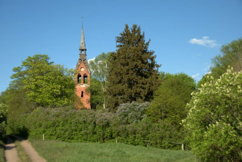
A red brick church tower stands partially obscured by trees and lush vegetation in a rural nature reserve, with a dirt path in the foreground.
The brick tower of the ruined church remains a distinctive landmark within the Małga Nature Reserve.

Małga Nature Reserve history and protected-area timeline

The reserve was established in 1991 by order of the Minister of Environmental Protection, Natural Resources, and Forestry, published in the Polish Monitor (Monitor Polski) under number 38, position 273, section 12. The legal designation reflected the growing recognition of the Omulew valley's importance as a nesting and feeding ground for rare bird species, and in particular as a communal roosting site for common cranes.

Over time, the area's boundaries were adjusted, with the reserve's surface expanding from an initial 147.09 hectares to the present 163.92 hectares, reinforcing its wetland and faunistic protection function within the Jedwabno Forest District framework.

Małga Nature Reserve landscape and geographic character

Małga lies within the Równina Mazurska (Masurian Plain), a relatively flat, post-glacial lowland shaped by the retreat of the ice sheet that once covered northern Poland. The reserve's defining feature is not relief but hydrology: a boggy, paludified stretch of the Omulew River valley where the river meanders through accumulated organogenic deposits.

The visible terrain is dominated by open wetland rather than forest. Sedge communities form broad, tussocky carpets across the valley floor, while tall reed beds line the shallow water zones. Along the margins, the wetland transitions into willow and birch thickets, creating a soft ecotone between open mire and the surrounding forest landscape administered by the Dębowiec and Uścianek forest ranges.

The brick tower of the ruined Protestant church in the former village of Małga rises above this otherwise low and quiet wetland scenery, serving as the most prominent vertical element in an otherwise horizontal landscape and reinforcing the sense of an abandoned rural setting being gradually reclaimed by hydrological processes.

Małga Nature Reserve ecosystems, habitats, and plant life

Ecologically, the reserve preserves a representative complex of lowland wetland habitats typical of the southern margin of the Masurian lake district. Its peatland character, classifying it among low peat bogs (torfowiska niskie), is shaped by the slow accumulation of organic material within the Omulew floodplain.

Vegetation follows a clear moisture and successional gradient. Open sedge marshes (turzycowiska) dominate the wettest core of the valley, providing both nesting cover and food resources for wetland birds. Reed beds (trzcinowiska) occupy transitional zones between open water and emergent vegetation, while willow and birch shrub communities mark higher, slightly drier edges where the wetland meets neighboring forest habitats.

Together, these communities form a functional mosaic in which water, peat, emergent vegetation, and woody thickets are closely interlinked, supporting a relatively high density of breeding birds and other wetland-dependent fauna.

Małga Nature Reserve wildlife and species highlights

The reserve derives its primary faunistic value from its birdlife, particularly the common crane, for which it protects one of the regionally important communal roosts. The crane gathering is the reserve's most widely recognized wildlife phenomenon, attracting both conservation interest and seasonal birdwatching attention.

In addition to cranes, the wetland habitats support breeding populations of several other bird species of conservation interest, including swans, black grouse, northern lapwings, and corncrakes. These species depend on the open sedge and reed communities that remain relatively undisturbed within the protected boundaries.

Larger mammals also make use of the wetland and its surrounding forest. Otters forage along the Omulew and its backwaters, and the reserve lies within a landscape that supports gray wolves, whose tracks and signs have been recorded in the area. Together, the bird and mammal communities illustrate how the reserve functions as both a breeding habitat and a node within a larger regional wildlife network.

Małga Nature Reserve conservation status and protection priorities

Małga is significant from a conservation perspective because it safeguards a rare combination of nesting and feeding habitat for several protected bird species and an intact lowland peatland ecosystem within the Masurian Plain. Its designation as both a faunistic and peatland reserve recognizes that the site's value is rooted in the interdependence between bird populations and the wetland vegetation that supports them.

Protection of the crane roost in particular gives the reserve visibility beyond the local region, as common crane gatherings are a conservation priority across much of northern and eastern Europe. By limiting disturbance in the core wetland, the reserve helps maintain conditions for successful breeding, feeding, and pre-migratory staging of these and other water-associated species.

At a broader scale, Małga contributes to the network of wetland and forest protected areas that together maintain the ecological coherence of the Warmian-Masurian landscape.

Małga Nature Reserve cultural meaning and human context

The reserve's setting within the abandoned village of Małga gives it a distinctive cultural dimension. The village, once home to a Protestant congregation, is now largely in ruins, with the surviving brick tower of its former church standing as the most recognizable landmark amid the wetland scenery.

This juxtaposition of a depopulated rural settlement and a thriving wetland landscape reflects broader patterns in the Warmian-Masurian region, where post-war demographic changes and shifts in land use have left many former communities largely reclaimed by natural processes, while their architectural traces remain embedded in the landscape.

Top sights and standout views in Małga Nature Reserve

The reserve's standout qualities include its combination of a lowland peatland ecosystem with a recognized crane roost, offering a rare case where habitat protection and a specific, visible wildlife phenomenon are closely aligned.

Its mosaic of sedge marshes, reed beds, and willow-birch thickets along the Omulew valley provides a strong example of the wetland complexes that once characterized large parts of the Masurian Plain, while the ruined church tower of Małga adds a memorable cultural landmark to an otherwise natural setting.

Best time to visit Małga Nature Reserve

The reserve is most rewarding for visitors during the warmer months, when open wetland habitats and their associated birdlife are most active. Spring and early summer offer the best prospects for observing breeding wetland birds, while late summer and early autumn, before migration, are traditionally associated with gathering and staging behavior in cranes and other waterbirds.

Wet conditions prevail throughout much of the year on the soft peat and silt soils of the valley, so any visit should be planned with appropriate footwear and an understanding that much of the area is best appreciated from observation points and forest roads rather than via direct walks across the wetland itself.

Monthly climate preview

Long-term representative point measurements tracking monthly averages across the protected area

Rezerwat przyrody Małga Climate Normals and Annual Temperature Rhythm

Representative coordinate records outline the measured annual temperature range and precipitation rhythm for Rezerwat przyrody Małga from 1991 to 2020. Examining the complete twelve-month climatology profile reveals deeper patterns in long-term averages across the protected landscape.
Annual mean7 °C
-4 °C19 °C
Jan-4°
Feb-3°
Mar
Apr
May13°
Jun16°
Jul19°
Aug18°
Sep13°
Oct
Nov
Dec-2°
Warmest month
July

18.7 °C

Coolest month
January

-4.2 °C

Wettest month
July

2.6 mm/day

Driest month
March

1.4 mm/day

Park location guide

Geography guide, regional context, and park location map for Małga Nature Reserve

Małga Nature Reserve park geography, regions, and map view in Poland

Understand where Małga Nature Reserve sits in Poland through a broader geographic reading of the surrounding landscape, nearby location context, and its mapped position within the national park landscape.

How Małga Nature Reserve fits into Poland

Poland, officially the Republic of Poland, is a Central European country spanning from the Baltic Sea in the north to the Carpathian Mountains in the south. It borders Germany, Czech Republic, Slovakia, Ukraine, Belarus, Lithuania, and Kaliningrad Oblast. The country has a temperate climate, diverse landscapes, and is known for its rich history, cultural heritage, and strong economic position within the EU.

Wider geography shaping Małga Nature Reserve in Poland

Poland occupies 312,696 km2 in Central Europe, extending from the Baltic Sea coast in the north to the Sudetes and Carpathian Mountains in the south. It borders Germany to the west, Czech Republic and Slovakia to the south, Ukraine and Belarus to the east, and Lithuania and Kaliningrad Oblast to the northeast. The landscape includes lowland plains, uplands, and mountain ranges.

Map view of Małga Nature Reserve

Use this park location map to pinpoint Małga Nature Reserve in Poland, understand its exact geographic position, and read its mapped placement within the surrounding landscape more clearly.

Pigeon | © OpenStreetMap contributors

Location context for Małga Nature Reserve

Warmian-Masurian Voivodeship

Visualizing the wetlands, river valleys, and protected habitats of northern Poland

Rezerwat przyrody Malga Photos and Landscape Scenery

Examine Rezerwat przyrody Malga photography to observe open sedge marshes, reed beds, and the winding Omulew River valley. Visual references reveal the low lowland terrain, wetland vegetation, and historical landmarks that define the protected landscape.

A red brick church tower stands partially obscured by trees and lush vegetation in a rural nature reserve, with a dirt path in the foreground.

Park atlas

Compare adjacent wetland reserves and regional sanctuaries across the Masurian Plain

Explore Other Parks Near Rezerwat przyrody Małga and Surrounding Protected Landscapes

Browsing protected areas near Rezerwat przyrody Małga reveals a connected network of lowland river valleys and peatland reserves. Comparing adjacent wetland habitats provides deeper context on the ecological and geographic patterns shaping the southern Masurian lake district.
Protected areaWarmian-Masurian Voivodeship
Mapped location lies within the park boundary#1 closest

Northwest

Puszcza Napiwodzko-Ramucka Protected Forest and Glacial Geography in Northeast Poland

An expansive lowland wilderness featuring unique sinkhole terrain.

Spanning over 117,000 hectares, Puszcza Napiwodzko-Ramucka stands as a massive pine-dominated forest complex in the Warmian-Masurian Voivodeship. The terrain is a masterclass in glacial history, defined by sandr plains, moraine hills, and a dense network of post-glacial lakes. This protected area functions as a critical sanctuary for raptor species and large mammals, while its distinct geology, marked by active suffosion processes, distinguishes it as a key subject for landscape-level study.

Area
1,173.2 km²
Relief
Lowland
Climate
Temperate
Access
Access unknown
Nature reserveWarmian-Masurian Voivodeship
About 8.2 km away#2 closest

Northwest

Dęby Napiwodzkie Nature Reserve: Geographic Overview and Protected Forest Boundaries

Ancient oak woodlands in Warmian-Masurian Voivodeship

Dęby Napiwodzkie preserves a unique mosaic of lowland forest communities, including rare old-growth pedunculate oaks that reach over three centuries in age. This nature reserve provides a critical, well-preserved look at the ecological diversity of the Warmian-Masurian landscape, featuring a dense concentration of forest types that have largely vanished elsewhere in the surrounding terrain.

Area
0.37 km²
Established
1989
Relief
Lowland
Climate
Temperate
A wide watercolor illustration showing a body of water curving through green forests with soft pink and yellow mountains in the background.
Protected areaWarmian-Masurian Voivodeship
About 20 km away#3 closest

West

Rezerwat przyrody Jezioro Orłowo Małe: Protected Area and Regional Geography

Wetland mosaic within the Masurian Plain

This protected area centers on a small lake and its surrounding forest stands, creating a vital habitat for the European pond turtle. Spanning 14.76 hectares in the Warmian-Masurian region, the reserve showcases the glacial topography and wetland biodiversity characteristic of the Polish landscape.

Area
0.148 km²
Established
1958
Relief
Lowland
Climate
Temperate
Nature reserveMasovian Voivodeship
About 38 km away#4 closest

Southeast

Zachodniokurpiowskie Bory Sasankowe: Protected Forest Geography and Reserve Map

A study of dry pine habitats in the Masovian Voivodeship

The Zachodniokurpiowskie Bory Sasankowe nature reserve serves as an essential reference for continental pine forest ecosystems. By protecting the delicate interplay between sandy dune topographies and lichen-rich woodland floors, this site provides a rare window into the post-glacial geography of the Kurpie Plain.

Area
22.141 km²
Established
2018
Relief
Lowland
Climate
Temperate
Protected landscapeWarmian-Masurian Voivodeship
About 51 km away#5 closest

West

Park Krajobrazowy Wzgórz Dylewskich: Protected Moraine Terrain and Regional Geography

A study of glacial landforms and hydrological patterns in the Warmian-Masurian Voivodeship

Explore the unique geomorphology of Park Krajobrazowy Wzgórz Dylewskich, where Pleistocene glaciation has carved steep slopes, deep valleys, and expansive hill summits. This protected landscape serves as a central hub for regional biodiversity and acts as a primary source for radiating water networks in northern Poland, offering a high-relief counterpoint to the surrounding lakeland.

Area
71.7 km²
Established
1994
Relief
Mountain
Scope
Terrestrial
Nature reserveWarmian-Masurian Voivodeship
About 52 km away#6 closest

West

Dylewo Nature Reserve: Protected Beech Woodland in the Warmian-Masurian Voivodeship

A study of glacial topography and rare fern habitats

Located within the Wzgórza Dylewskie landscape park, Dylewo Nature Reserve protects a stable, closed-canopy beech woodland on elevated morainic terrain. Gain deeper insights into the forest composition and the ecological importance of this site as a sheltered habitat for rare flora within the larger northern Polish lakeland region.

Area
0.101 km²
Established
1970
Relief
Mountain
Scope
Terrestrial
A soft watercolor painting showing a green marshy landscape with tall grasses, calm water, and gentle rolling hills in the background.
Nature reserveWarmian-Masurian Voivodeship
About 54 km away#7 closest

East

Rezerwat przyrody Jezioro Nidzkie: Protected Area and Regional Landscape Geography

Mapping the forest and lake terrain of the Mazurian Plain

Examine the geographic characteristics of Rezerwat przyrody Jezioro Nidzkie, a protected nature reserve nestled within the Piska Forest. This profile tracks the spatial distribution of alder swamps, pine forests, and postglacial waters that create a distinct ecological mosaic across the Warmian-Masurian landscape.

Area
29.509 km²
Established
1972
Relief
Lowland
Climate
Temperate
Nature reserveWarmian-Masurian Voivodeship
About 55 km away#8 closest

North

Rezerwat przyrody Dębowo Nature Reserve: Geography and Forest Protected Area Overview

A preserved lowland beech woodland within the Warmian-Masurian Voivodeship

Rezerwat przyrody Dębowo stands as a vital representative of mixed lowland forest ecosystems at the eastern edge of their natural range. The reserve protects a complex, multi-layered canopy and a rich herb layer including species like the Martagon lily and wild garlic. By safeguarding these veteran beech stands, the site provides a primary reference for understanding forest development and biogeographical boundaries within the broader Mrągowski Lakeland landscape.

Area
0.258 km²
Established
1954
Relief
Lowland
Scope
Terrestrial

Common questions about visiting, size, designation, and location context for Małga Nature Reserve

Małga Nature Reserve FAQs for park facts, access, geography, and protected area context

Find quick answers about Małga Nature Reserve, including protected-area facts, park geography, trail and visitor context, and how the park fits into its surrounding country and regional landscape.
MoriAtlas Explorer

Continue Your Protected Areas Search Across the Global Atlas

Deepen your exploration by continuing the structured search for national parks and protected areas worldwide. Utilize the comprehensive filtering capabilities to compare different conservation landscapes and refine your understanding of global park geography. Discover more about the distribution and characteristics of protected natural areas.

Global natural geography