
Mori Atlas logo
Natural monumentMalý Uran

Explore the Precambrian bedrock and unique juniper habitats defining this protected regional landscape

Malý Uran Natural Monument: A Geological and Botanical Study of Central Bohemian Valley Slopes

Malý Uran sits within the Rakovník district, serving as a critical protected natural monument that highlights the diverse lithology of the Central Bohemia Region. This area encompasses sharp valley slopes above the Kosobodský stream, where Precambrian and Proterozoic geology provides a specialized substrate for aged juniper stands. Through its combination of graphitic shale outcrops and thin skeletal soils, the site offers an instructive look at small scale ecological conservation and regional geomorphology.

natural monumentjuniper habitatrocky slopesvalley slopePrekambrian geologyProterozoic bedrock
A stylized vector illustration of a mountainous landscape with a river flowing through a forested valley, a waterfall on the right, and a log in the foreground.

Malý Uran

Natural monument

Park overview

Structured park overview, official facts, and landscape profile for Malý Uran

Malý Uran park facts, protected area profile, and essential visitor context

Review the core facts for Malý Uran, including designation, size, terrain, visitor scale, habitats, and operating context in one park-focused overview.

About Malý Uran

Malý Uran is a compact natural monument located in the Central Bohemian Region of the Czech Republic, in the rolling countryside northwest of Prague near the town of Kosobody. The protected area covers roughly fifteen hectares of valley slopes along the Kosobodský potok, a small watercourse that has cut into ancient bedrock and shaped the local terrain.

The site belongs to the Czech přírodní památka category, a designation used for smaller but ecologically meaningful natural features. Malý Uran was declared in 1996 by the local district authority and is currently administered through the regional government of Central Bohemia. Its location near the boundary between the Kosobody and Oráčov cadastres places it in a rural landscape where traditional land use, including former pastureland, has shaped the present vegetation patterns.

The defining character of Malý Uran arises from a convergence of geology, topography, and vegetation. The slopes above the Kosobodský stream expose ancient Precambrian sulfide shales and Proterozoic biotite granites, weathered into shallow skeletal soils that can only support specialized, hardy plant communities. This substrate hosts scattered rocky outcrops, residual juniper shrubs, and ecological conditions that make the small site disproportionately interesting from a botanical and geoconservation perspective.

For visitors and researchers, Malý Uran is less a destination park than a focused natural monument: a place whose value lies in the specific ecological detail it preserves rather than in dramatic scenery. Even so, it represents the kind of small, clearly defined protected site that gives the Bohemian countryside much of its natural distinctiveness.

Quick facts and research context for Malý Uran

Malý Uran is a Czech natural monument (přírodní památka) administered at the regional level by the Central Bohemian Region authority. It lies in the Rakovník district, specifically in the cadastral territories of Kosobody and Oráčov, and was established on 1 June 1996 by the former Rakovník District Office.

The site encompasses about 15.92 hectares of terrain at elevations between approximately 440 and 500 meters. Its protected subject is the rocky slopes above the Kosobodský stream, where common juniper grows on soils derived from Precambrian sulfide shales and Proterozoic biotite granites at their contact zone.

Park context

Deeper park guide and search-rich context for Malý Uran

Malý Uran history, landscape, wildlife, and travel context

Explore Malý Uran through its history, landscape character, ecosystems, wildlife, conservation priorities, cultural context, and seasonal travel timing in a structured park guide built for atlas discovery and search intent.

Why Malý Uran stands out

Malý Uran is best known for its rocky valley-slope juniper habitat, where common juniper (Juniperus communis) clings to shallow skeletal soils above the Kosobodský stream. The site stands out as one of the localized Bohemian refuges where old juniper shrubs persist on geologically distinctive Precambrian and Proterozoic substrates, including graphitic shale outcrops that are unusual in the regional landscape.
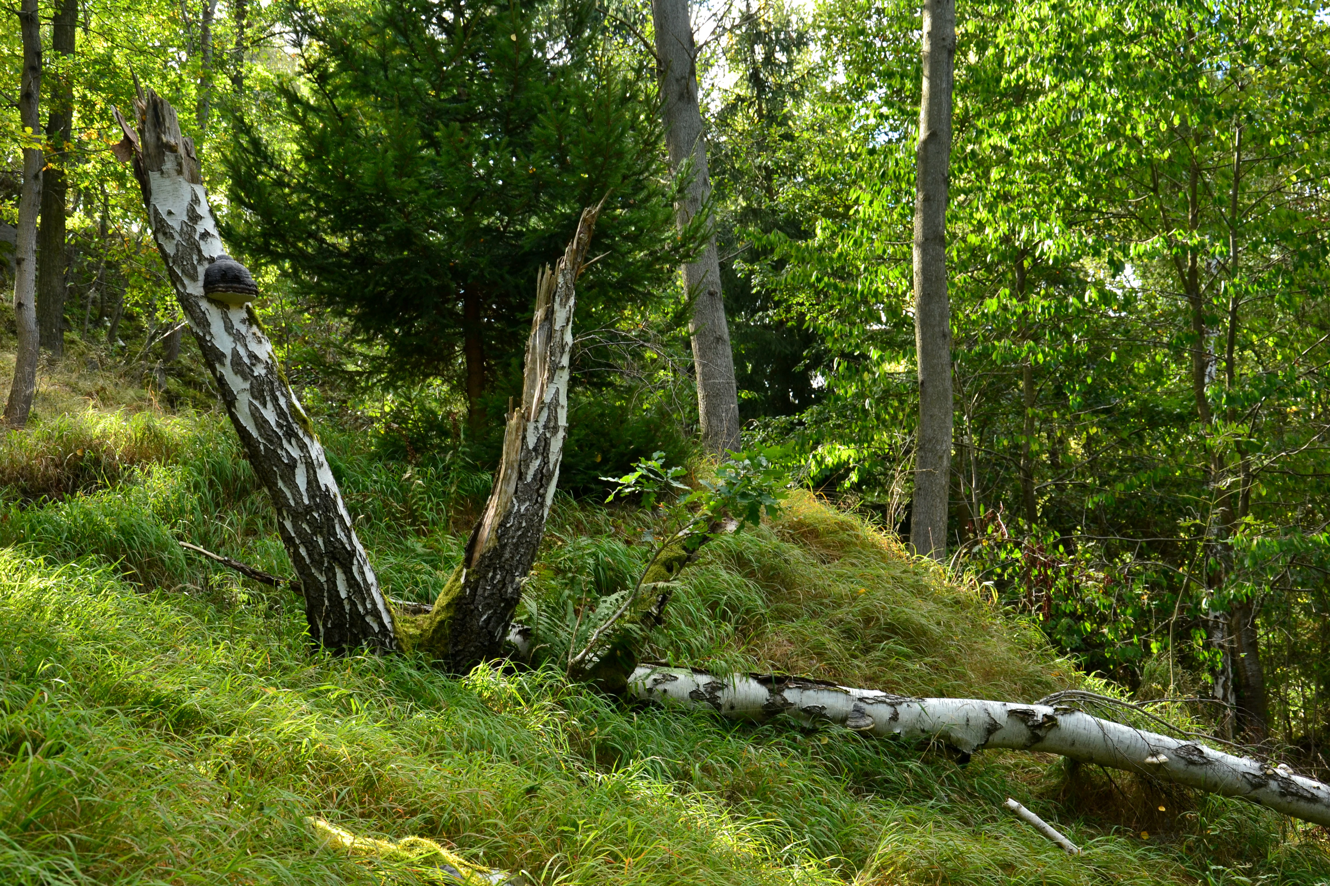
A forest scene showing a grassy, sloped hillside with a prominent split, fallen birch tree trunk in the foreground, surrounded by other trees and greenery.
A forested slope in the Malý Uran natural monument, featuring a fallen birch tree.

Malý Uran history and protected-area timeline

Malý Uran was officially designated as a natural monument (přírodní památka) on 1 June 1996 by the Okresní úřad Rakovník, the former district authority of Rakovník. The declaration recognized the conservation value of the rocky valley slopes above the Kosobodský stream, particularly the surviving juniper population growing on the geologically distinctive Prekambrian substrate.

The site's protected status responded to long-running ecological change in the area, where former pastureland on the slopes had gradually shifted toward more natural, sparse vegetation that allowed juniper shrubs to persist into older age classes. By the early twenty-first century, field surveys, including a 2006 terrain assessment, documented an aged juniper population with limited natural regeneration, underscoring the conservation importance of the site.

Today the area is managed at the regional level through the Central Bohemian Region authority (Krajský úřad Středočeského kraje), reflecting the broader Czech practice of regional stewardship for smaller natural monuments.

Malý Uran landscape and geographic character

The landscape of Malý Uran is defined by a modest but sharply characterized valley slope along the Kosobodský potok. The terrain rises from the stream channel up toward elevations around 440 to 500 meters above sea level, creating a steep slope that exposes bedrock at multiple points along its face.

The geological backdrop is unusually rich for such a small area. Rocks here belong to the Prekambrian and Proterozoic eras, including sulfide-bearing shales (kyzové břidlice) and graphitic shales, along with biotitic granites at their contact zone. Some of these shales have been altered into algoncan phyllites. The varied lithology weathers into shallow, skeletal soils that are too thin and dry to support closed forest, leaving the slope dotted with low outcrops and open patches.

This combination of steep slopes, scattered rock, and thin soil gives the site a visually distinct micro-landscape within the otherwise agricultural Rakovník district. The valley setting above the stream creates locally cooler, rougher microclimates that contrast with surrounding farmland.

Malý Uran ecosystems, habitats, and plant life

The ecological character of Malý Uran is shaped principally by its substrate and land-use history. Shallow skeletal soils derived from Prekambrian sulfide shales and graphitic shales support only patchy, stress-tolerant vegetation, and the slope's exposure further restricts plant cover. These conditions have historically limited competition from taller or faster-growing species.

Where the underlying Precambrian and Proterozoic rocks meet at the contact zone, additional mineral and chemical variability in the soil contributes to localized habitat differences, an important feature for the conservation of specialized plant communities in a small area. The site's botanical focus is juniper: the surviving shrubs of Juniperus communis are concentrated along the edges of the slope on the thinnest soils.

Vegetation structure is open rather than closed, with the rocky outcrops breaking up the slope into a mosaic of bare rock, low shrubs, and herbaceous patches. This pattern reflects the older pastoral history of the site, where grazing once helped keep the slope open; subsequent land-use change and the resulting ecological dynamics help explain the current character of the reserve.

Malý Uran wildlife and species highlights

Wildlife coverage in the available Czech sources focuses primarily on the plant communities of Malý Uran rather than on fauna. There is no detailed information about mammals, birds, or invertebrates in the source material.

The site's ecological role for animals is best understood indirectly: the open juniper stands on rocky slopes and the mosaic of bare rock, low shrubs, and grassy patches create structurally varied habitat that typically supports reptiles, pollinators, and smaller ground-dwelling species in similar Bohemian sites. However, specific fauna for Malý Uran is not documented in the supplied text and should not be inferred here.

Malý Uran conservation status and protection priorities

Malý Uran's conservation importance lies in the survival of an old and minimally regenerating population of common juniper (Juniperus communis) on a geologically distinctive Prekambrian and Proterozoic substrate in the Central Bohemian Region. By the 2006 terrain survey, the site contained approximately fifty older juniper shrubs and only two younger, regenerating individuals, a profile that signals both ecological fragility and a clear conservation rationale.

The protected designation as a přírodní památka in 1996 formally recognized the slope as the key conservation subject, with protection directed specifically at the juniper habitat and the rocky slopes above the Kosobodský stream. Management responsibility currently sits at the regional level with the Central Bohemian Region, consistent with the Czech framework in which smaller natural monuments are commonly stewarded by krajské úřady.

Geoconservation is a secondary but notable element of the site's value. The exposed Precambrian sulfide shales, graphitic shales, altered phyllites, and Proterozoic biotite granites give the small area an unusually informative geological cross-section, justifying the rock exposures as a meaningful element of the protected landscape.

Malý Uran cultural meaning and human context

The cultural context of Malý Uran is largely tied to traditional rural land use in the Rakovník district, where former pasture shaped the open character of the slopes above the Kosobodský stream. This grazing history contributed to the conditions that, in turn, allowed the juniper stands to persist as an open-habitat feature rather than being shaded out by forest regrowth.

There is no documented broader cultural, folkloric, or historical narrative attached specifically to this site in the source material. The reserve's character as a small natural monument reflects the wider Czech regional approach of formalizing locally meaningful ecological features rather than tying protected status to prominent cultural landmarks.

Top sights and standout views in Malý Uran

The standout features of Malý Uran are its ancient geological substrate, the open rocky juniper slopes above the Kosobodský stream, and the unusually informative contact zone between Prekambrian sulfide shales and Proterozoic biotite granites. These elements combine into a compact natural monument whose value lies in ecological and geoconservation specificity rather than scenic scale.

Best time to visit Malý Uran

Because Malý Uran is a small natural monument rather than a developed visitor destination, seasonal timing is best considered in terms of ecological observation rather than access. Late spring and early summer tend to be favorable for observing the open juniper stands and rocky slopes in the Bohemian countryside, when low herbaceous vegetation and warmer temperatures make the varied substrate easier to read on the slope. Winter and early spring can reveal the rock exposures and juniper silhouettes more clearly, though access to the slopes may be limited by weather and agricultural surroundings.

Visitors should treat any visit as a quiet, local natural-area experience rather than a tourism itinerary.

Monthly climate preview

Long-term representative averages and weather by month for Central Bohemia Region

Malý Uran Climate Normals: Annual Temperature and Precipitation Rhythm

Recorded baseline measurements outline the long-term temperature swings and monthly precipitation patterns across representative coordinates in Malý Uran. Detailed examination of the complete twelve-month normals reveals precise monthly averages for studying regional environmental conditions.
Annual mean8 °C
-2 °C19 °C
Jan-2°
Feb-1°
Mar
Apr
May13°
Jun17°
Jul19°
Aug19°
Sep14°
Oct
Nov
Dec-1°
Warmest month
July

19.2 °C

Coolest month
January

-2.4 °C

Wettest month
June

2.6 mm/day

Driest month
February

1.1 mm/day

Park location guide

Geography guide, regional context, and park location map for Malý Uran

Malý Uran park geography, regions, and map view in Czechia

Understand where Malý Uran sits in Czechia through a broader geographic reading of the surrounding landscape, nearby location context, and its mapped position within the national park landscape.

How Malý Uran fits into Czechia

Czech Republic is a landlocked Central European country with a population of approximately 10.9 million people. The nation was established as an independent state on January 1, 1993, following the dissolution of Czechoslovakia. Its capital and largest city is Prague, with other major urban centers including Brno, Ostrava, Plzeň, and Liberec.

Wider geography shaping Malý Uran in Czechia

The Czech Republic is a landlocked country in Central Europe. It is bordered by Germany to the west, Austria to the south, Poland to the northeast, and Slovakia to the southeast. The landscape is predominantly hilly, with the territory covering 78,871 square kilometers.

Map view of Malý Uran

Use this park location map to pinpoint Malý Uran in Czechia, understand its exact geographic position, and read its mapped placement within the surrounding landscape more clearly.

Pigeon | © OpenStreetMap contributors

Location context for Malý Uran

Central Bohemia Region

Explore detailed imagery of rocky terrain, rare geological substrates, and sparse juniper stands across the reserve.

Malý Uran Photos and Protected Area Scenery: Visualizing Valley Slopes and Juniper Habitats

Visual records illustrate the steep valley slopes, exposed bedrock, and skeletal soils that define the protected environment of Malý Uran. Examining field photography helps researchers and visitors understand the micro-landscape and botanical communities thriving within this Central Bohemian natural monument.

A forest scene showing a grassy, sloped hillside with a prominent split, fallen birch tree trunk in the foreground, surrounded by other trees and greenery.

Park atlas

Compare regional valley landscapes and adjacent Bohemian natural monuments

Explore Other Protected Areas and Nearby Parks Around Malý Uran

Browse other protected areas near Malý Uran to examine contrasting valley terrain and regional geological formations. Comparing adjacent reserves expands your understanding of local botanical habitats and protected landscapes across the surrounding district.
A minimalist watercolor painting depicting rolling hills and a meadow landscape in soft shades of green and pink.
Natural monumentÚstí nad Labem Region
About 13 km away#1 closest

North

Soběchlebské terasy Natural Monument: Geography and Protected Ravine Landscapes

Regional protected area analysis in the Ústí nad Labem Region

Soběchlebské terasy is a specialized natural monument situated in the Louny district, protecting a deep, narrow stream valley carved by the Černocký stream. The landscape is characterized by its steep, terraced woodland slopes, providing an essential thermophilic environment for rare orchids and oak-dominated forest fragments within the northwestern Czech Republic.

Area
0.026 km²
Established
2011
IUCN
IV
Relief
Upland
A watercolor painting showing a river valley with coniferous trees, rocky riverbanks, and distant rolling hills in a soft, pastel palette.
Protected landscapeCzechia
About 16 km away#2 closest

West

Přírodní park Horní Střela: Protected Landscape and Geography in Czechia

Geological canyons and basalt uplands in western Bohemia

Přírodní park Horní Střela showcases a layered landscape shaped by the Střela River. The area features deep canyons, rocky slate slopes, and characteristic basalt-topped summits that create a diverse ecological mosaic within the Czech landscape.

Area
99.92 km²
Established
1978
Relief
Upland
Climate
Temperate
Natural monumentCentral Bohemian Region
About 20 km away#3 closest

Southeast

Valachov Natural Monument: Geological and Historical Landscape Analysis in Central Bohemia

Mineralogical type locality and industrial-archaeological protected area.

Valachov is a small yet significant natural monument located in the Central Bohemian Region, serving as the primary type locality for the mineral slavíkit. Beyond its mineralogical importance, the hill preserves physical evidence of medieval lead and nineteenth-century pyrite mining, including shafts and adits embedded within a diverse forested ecosystem of the Křivoklátsko protected landscape area.

Area
0.03 km²
Established
1977
IUCN
III
Relief
Upland
Natural monumentÚstí nad Labem Region
About 21 km away#4 closest

Northwest

Vrbina u Nové Vsi Natural Monument: Protected Habitat Mapping and Geographic Overview

Wetland and meadow conservation in the Ústí nad Labem Region

Vrbina u Nové Vsi provides a deep look into the habitat mosaic of the Doupov Mountains foothills. This protected area stands out for its concentrated distribution of ten distinct biotopes, ranging from wet alder woodlands to orchid-rich meadows, providing a comprehensive example of lowland conservation within a larger volcanic terrain context.

Area
0.113 km²
Established
2016
IUCN
IV
Relief
Upland
Natural monumentKarlovy Vary District
About 21 km away#5 closest

Northwest

Valečské sklepy Natural Monument and Protected Bat Hibernation Site in Karlovy Vary

Volcanic terrain and critical wildlife infrastructure in western Bohemia

Valečské sklepy represents a unique form of protected landscape in the Karlovy Vary District, where historical underground cellars function as a specialized natural monument. The site maintains a crucial role as a winter hibernation refuge for the critically endangered western barbastelle, embedded within the volcanic geomorphology of the Doupovské hory region.

Established
2016
IUCN
III
Relief
Mountain
Climate
Temperate
A soft, light-toned watercolor painting depicting a green, hilly landscape with a winding path in the foreground.
Protected landscapeStředočeský kraj
About 23 km away#6 closest

Northeast

Přírodní park Džbán: Geography and Protected Landscape Analysis of the Džbán Ridge

Forested highland and hydrological center of Středočeský kraj

Přírodní park Džbán encompasses a significant Cretaceous plateau and mixed-woodland system that functions as a triple watershed for three major river basins. The park preserves a rich mosaic of thermophilic plants and woodland fauna while maintaining the characteristic opuka geological features that define the vernacular architecture of this central Bohemian region.

Area
416 km²
Established
1994
Relief
Upland
Climate
Temperate
Natural monumentKarlovarský kraj
About 23 km away#7 closest

Northwest

Valeč Natural Monument: Geologic and Ecological Landscapes in the Karlovarský kraj

Tracing volcanic terrain and fossil sites in the Doupovské Hory

Valeč Natural Monument offers a deep look into the volcanic geology and protected wilderness of western Bohemia. Known for its historical paleontological finds and diverse forest cover, this landscape provides an essential case study for mineralogical research and habitat preservation within the wider regional geography.

Area
5.436 km²
Established
1992
IUCN
IV
Relief
Mountain
A wide watercolor illustration showing a winding river, a line of green trees, and soft rolling hills in pastel green, pink, and purple tones against a white background.
Natural monumentStředočeský kraj
About 23 km away#8 closest

Southeast

Skryjsko-týřovické kambrium: A Scientific Natural Monument and Geological Landmark

Paleontological heritage in the central Bohemian hills.

Skryjsko-týřovické kambrium provides essential protection for fossil-bearing Cambrian strata in the Czech Republic. This landmark, managed as a natural monument within the Středočeský kraj, remains a foundational reference site for international researchers exploring early Paleozoic marine life, characterized by its unique rock outcrops along the Berounka river valley.

Area
0.3 km²
Established
2011
IUCN
IV
Relief
Upland

Common questions about visiting, size, designation, and location context for Malý Uran

Malý Uran FAQs for park facts, access, geography, and protected area context

Find quick answers about Malý Uran, including protected-area facts, park geography, trail and visitor context, and how the park fits into its surrounding country and regional landscape.
MoriAtlas Explorer

Continue Your Protected Areas Search Across the Global Atlas

Deepen your exploration by continuing the structured search for national parks and protected areas worldwide. Utilize the comprehensive filtering capabilities to compare different conservation landscapes and refine your understanding of global park geography. Discover more about the distribution and characteristics of protected natural areas.

Global natural geography