
Mori Atlas logo
Nature reserveMarpetal mit Passade und Zufluesse

A detailed geographic study of lowland river corridors and riparian landscapes in Westphalia

Marpetal mit Passade und Zufluesse: Protected Stream Valley and Nature Reserve Mapping

(Naturschutzgebiet „Marpetal mit Passade und Zuflüsse")

Marpetal mit Passade und Zufluesse represents a significant nature reserve in the district of Lippe, North Rhine-Westphalia, protecting a vital lowland stream network. This area preserves a mosaic of riparian habitats, wooded slopes, and floodplains shaped by the confluence of the Passade river and the Marpe tributary. Serving as a crucial link within a regional network of protected lands, the reserve offers insight into the undulating rural terrain and cultural landscape of the eastern Westphalian countryside.

nature reservestream valleylowland riverriparian habitatNorth Rhine-WestphaliaKreis Lippe
Stylized digital illustration showing a stone arch bridge crossing a calm river in a valley, framed by tall trees with soft pastel colors and mountains in the distance.

Marpetal mit Passade und Zufluesse

Nature reserve

Park overview

Structured park overview, official facts, and landscape profile for Marpetal mit Passade und Zuflüsse

Marpetal mit Passade und Zuflüsse park facts, protected area profile, and essential visitor context

Review the core facts for Marpetal mit Passade und Zuflüsse, including designation, size, terrain, visitor scale, habitats, and operating context in one park-focused overview.

About Marpetal mit Passade und Zuflüsse

Marpetal mit Passade und Zuflüsse is a compact nature reserve in the district of Lippe, situated in the rural surroundings of the town of Blomberg in the German state of North Rhine-Westphalia. Officially classified as a Naturschutzgebiet, the site functions as a long-term conservation area for a segment of the local river landscape, with particular attention given to the Passade and one of its small right-bank tributaries, the Marpe.

The protected area stretches northwest of Blomberg's center and around the Cappel district, straddling the district road 89 that links the surrounding communities. It is bordered on the northeast and southeast by the regional road L712, while the larger Hurn nature reserve continues the network of protected valley landscapes immediately to the southeast. Together, these reserves form a string of interconnected stream valleys typical of the eastern Westphalian countryside.

Although the reserve is modest in size, it carries clear ecological importance within the regional system. The designation, registered under the code LIP-052 and recorded in the World Database on Protected Areas as entry 344724, reflects its integration into the formal German nature conservation framework. Management is handled by the district administration of Lippe, which oversees a number of similarly sized reserves across the area.

Beyond its ecological function, the valley is identified as a regionally significant cultural landscape element by the Landschaftsverband Westfalen-Lippe, recognized under the designation of the Passade, Marpe, and Donopetal cultural landscape area. This underscores that the site is appreciated not only for its natural values but also for its role within the historical character of the Lippe countryside.

Quick facts and research context for Marpetal mit Passade und Zuflüsse

Marpetal mit Passade und Zuflüsse is a designated nature reserve, known in German as a Naturschutzgebiet, located in the town of Blomberg in the Lippe district of North Rhine-Westphalia, in northwestern Germany. It lies northwest of Blomberg's central town and extends around the Cappel district on both sides of the district road K89.

The reserve has the official identification code LIP-052, corresponds to World Database on Protected Areas record 344724, and covers approximately 0.89 square kilometers. It was placed under formal protection in 2005 and is administered by the Lippe district office. The Passade river and its right tributary Marpe flow through the protected area, with the regional road L712 running along part of its northeastern and southeastern edge.

Protection and recognition

Examine documented protection records and official designation data for this protected area.

Marpetal mit Passade und Zufluesse Protection Status and International Recognition

Marpetal mit Passade und Zufluesse holds documented protection status details compiled within international conservation databases. Structured records outline the formal designation framework and administrative background associated with the protected landscape.

Protection details

WDPA ID
344724
Park context

Deeper park guide and search-rich context for Marpetal mit Passade und Zuflüsse

Marpetal mit Passade und Zuflüsse history, landscape, wildlife, and travel context

Explore Marpetal mit Passade und Zuflüsse through its history, landscape character, ecosystems, wildlife, conservation priorities, cultural context, and seasonal travel timing in a structured park guide built for atlas discovery and search intent.

Why Marpetal mit Passade und Zuflüsse stands out

Marpetal mit Passade und Zuflüsse is best known for protecting a small, well-defined river valley ecosystem around the Passade and its tributary Marpe. Its value lies in preserving a connected lowland stream corridor, including adjacent slopes and floodplain elements, in a region where agricultural land use and settlement pressure are otherwise intense. The reserve also serves as a building block within the wider network of Lippe nature reserves, contributing to the continuity of protected stream valley landscapes that ultimately link to the larger Hurn reserve just to the southeast.
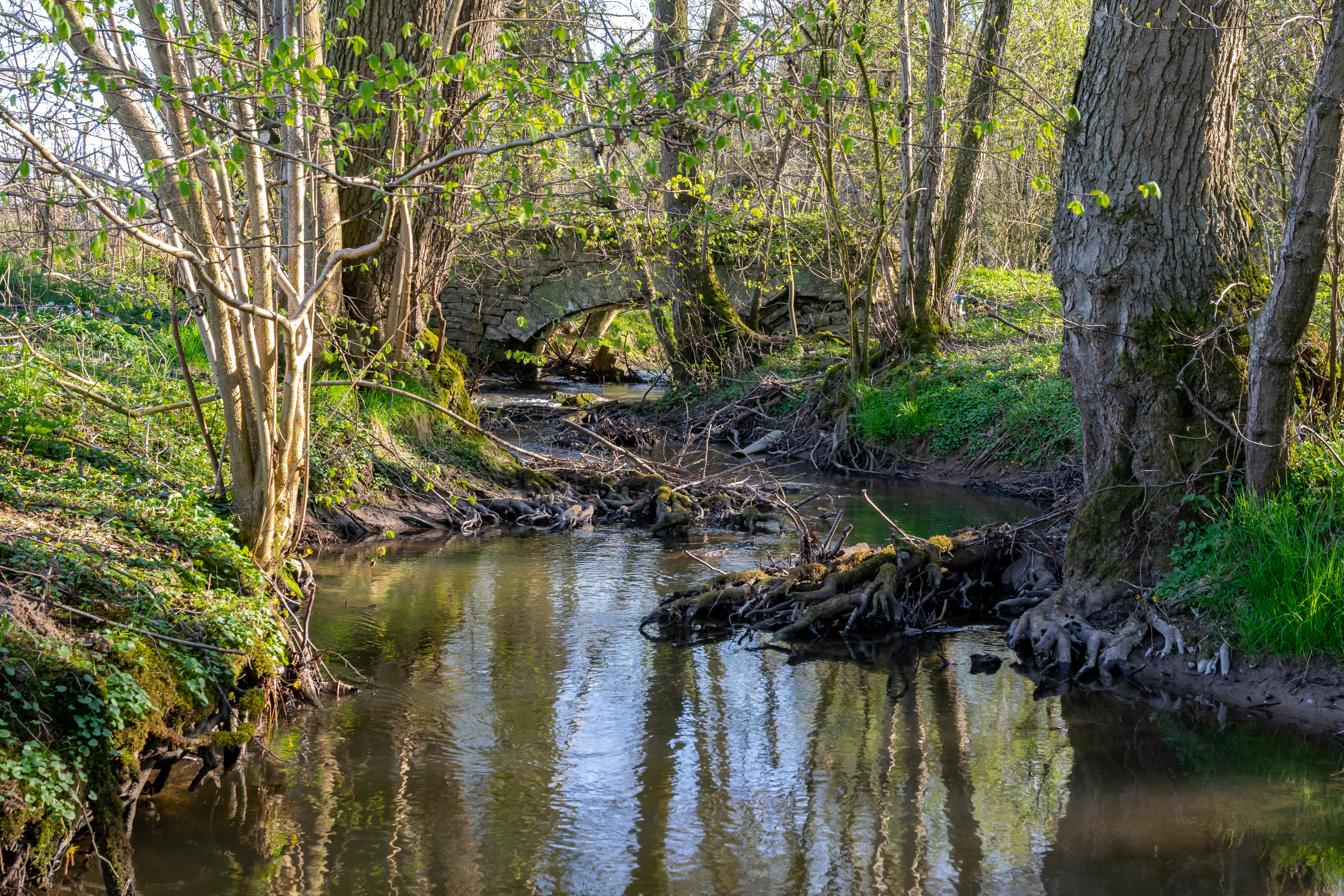
A small stone arched bridge crosses a narrow, calm stream in a lush, wooded valley, with trees and spring vegetation lining the banks.
A stone bridge spans the Passade stream in the Marpetal nature reserve during spring.

Marpetal mit Passade und Zuflüsse history and protected-area timeline

The area now known as Marpetal mit Passade und Zuflüsse was placed under formal nature protection in the year 2005. Its designation as a Naturschutzgebiet, under the official identification code LIP-052, brought the valley of the Passade and the Marpe stream into the regulated conservation framework of the state of North Rhine-Westphalia.

Since its designation, the reserve has been administered by the Kreis Lippe district office, which is also responsible for a number of other small protected areas in the Blomberg area. The 2005 establishment continued a broader pattern during that period of expanding the formal network of small stream valley reserves throughout the Lippe district.

Parallel to its recognition as a nature reserve, the area has been documented as a regionally significant cultural landscape by the Landschaftsverband Westfalen-Lippe, which lists the Passade, Marpe, and Donopetal landscape under the cultural landscape reference code K 08.19. This joint recognition reflects both natural and cultural value being acknowledged within the regional planning framework.

Marpetal mit Passade und Zuflüsse landscape and geographic character

The landscape of Marpetal mit Passade und Zuflüsse is shaped by a compact network of shallow valleys and stream corridors. The Passade river flows through the reserve together with the Marpe, a smaller right-bank tributary that joins the Passade within or near the protected area. These lowland streams have carved gentle valleys into the surrounding countryside, producing the mix of wet margins, slopes, and small floodplains that define the terrain.

The reserve lies in a predominantly rural setting northwest of the historic center of Blomberg and around the Cappel district. The district road 89 runs through the area, while the regional road L712 defines part of its outer edge. To the southeast, the protected landscape continues directly into the larger 226.2 hectare Hurn nature reserve, extending the valley character of the area across administrative boundaries.

Overall, the terrain reflects the quiet, undulating character of the eastern Westphalian countryside, where woodland patches, small fields, and stream valleys alternate in a typical lowland mosaic.

Marpetal mit Passade und Zuflüsse ecosystems, habitats, and plant life

The nature of Marpetal mit Passade und Zuflüsse centers on the ecological character of a lowland stream valley in northwestern Germany. The reserve protects a segment of the Passade river system along with the headwaters and lower course of the Marpe tributary, creating a connected corridor of riparian habitat that links upstream and downstream environments.

Although the protected area is relatively small at roughly 89 hectares, it gains value through its function as a continuous natural corridor. Wet margins along the streams, the slopes that frame the valley, and the transition zones between watercourse and surrounding agricultural land all form part of the protected mosaic. The reserve also connects ecologically with the larger Hurn reserve to the southeast, helping to extend the natural character of the valley beyond the formal boundary of this site.

Within the broader Lippe district network, Marpetal mit Passade und Zuflüsse plays a role alongside other small reserves around Blomberg, Cappel, and neighboring communities, contributing to the persistence of functioning lowland stream ecosystems in a region otherwise shaped by farming and settlement.

Marpetal mit Passade und Zuflüsse wildlife and species highlights

The sources available do not provide specific detail on individual species or species groups recorded within the Marpetal mit Passade und Zuflüsse reserve. The reserve's character as a lowland stream corridor, however, suggests that its wildlife interest centers on species typically associated with small Westphalian river valleys, including stream-dependent fauna and habitat specialists of the riparian margins.

Marpetal mit Passade und Zuflüsse conservation status and protection priorities

Marpetal mit Passade und Zuflüsse has been formally protected since 2005 as part of the German Naturschutzgebiet system, registered under the code LIP-052 and entered in the World Database on Protected Areas as record 344724. Its designation reflects the recognized value of preserving a representative valley section of the Passade and Marpe stream system within a heavily used rural landscape.

The reserve is administered by the Kreis Lippe district, ensuring that the site is integrated into the regional conservation planning of the Lippe area. Its placement alongside the larger Hurn nature reserve strengthens its conservation significance, as the two sites together form a more continuous protected stretch of valley habitat than either could provide alone.

The combined natural and cultural landscape recognition by the Landschaftsverband Westfalen-Lippe, under the reference code K 08.19 for the Passade, Marpe, and Donopetal area, adds an extra layer of regional planning support. Together, these layers of recognition underline that the reserve's conservation role extends beyond a single small valley, contributing to the persistence of lowland stream ecosystems throughout the wider Lippe district.

Marpetal mit Passade und Zuflüsse cultural meaning and human context

The Passade and Marpe valley landscape has been formally recognized as a regionally significant cultural landscape area by the Landschaftsverband Westfalen-Lippe. It is included in the cultural landscape catalogue under reference code K 08.19, recorded as the Passade-, Marpe- and Donopetal area. This recognition underscores the long-standing interaction between human land use and the river valleys, where farming, settlement, and the natural valley form have shaped each other over time.

The reserve's position around the Cappel district and northwest of Blomberg's historic center places it within a traditional rural setting of the Lippe region, where small communities have long been connected by the local road network, including the district road K89 that passes through the protected area.

Top sights and standout views in Marpetal mit Passade und Zuflüsse

Marpetal mit Passade und Zuflüsse highlights the continuing ecological and cultural value of small river valleys in the Lippe district of North Rhine-Westphalia. Its compact size belies its role as a meaningful link within a larger network of stream valley reserves that includes the adjacent Hurn area.

The combination of formal nature protection since 2005, district-level administration under Kreis Lippe, and regional cultural landscape recognition gives the site a layered significance. It stands as an example of how modest but well-placed nature reserves can preserve representative lowland stream ecosystems while also reflecting the historical rural character of the Westphalian countryside.

Best time to visit Marpetal mit Passade und Zuflüsse

The source material does not provide specific seasonal or visitor-oriented information for Marpetal mit Passade und Zuflüsse. As a lowland stream valley reserve in northwestern Germany, the site's character shifts with the seasons typical of the region: fresh green vegetation and active streams in spring, dense foliage in summer, colorful forest margins in autumn, and quieter, more open vistas in winter. Visitors interested in natural scenery would generally find late spring and early autumn particularly rewarding for valley landscapes in this region.

Monthly climate preview

Long-term representative temperature and monthly precipitation averages across the protected area

Marpetal mit Passade und Zufluesse Climate Normals and Annual Weather Rhythm

Marpetal mit Passade und Zufluesse exhibits a measured annual temperature range from subzero winter minima to warm summer maximums alongside steady monthly precipitation values. Exploring the complete twelve-month profile provides detailed meteorological data and comprehensive climate normals for this location.
Annual mean9 °C
1 °C18 °C
Jan
Feb
Mar
Apr
May13°
Jun16°
Jul18°
Aug18°
Sep14°
Oct
Nov
Dec
Warmest month
July

18.1 °C

Coolest month
January

0.5 °C

Wettest month
December

2.6 mm/day

Driest month
April

1.6 mm/day

Park location guide

Geography guide, regional context, and park location map for Marpetal mit Passade und Zuflüsse

Marpetal mit Passade und Zuflüsse park geography, regions, and map view in Germany

Understand where Marpetal mit Passade und Zuflüsse sits in Germany through a broader geographic reading of the surrounding landscape, nearby location context, and its mapped position within the national park landscape.

How Marpetal mit Passade und Zuflüsse fits into Germany

Germany is a federal republic in Western and Central Europe with a population of over 83 million across sixteen constituent states. It is Europe's largest economy by nominal GDP and a major global exporter and importer. The capital is Berlin, and the country borders Denmark, Poland, Czech Republic, Austria, Switzerland, France, Luxembourg, Belgium, and the Netherlands.

Wider geography shaping Marpetal mit Passade und Zuflüsse in Germany

Germany is located in Western and Central Europe, spanning 357,022 km². It borders Denmark to the north, Poland and the Czech Republic to the east, Austria and Switzerland to the south, and France, Luxembourg, Belgium, and the Netherlands to the west. The country has coastlines on the Baltic Sea and North Sea to the north, with the Alps located in the southern region.

Map view of Marpetal mit Passade und Zuflüsse

Use this park location map to pinpoint Marpetal mit Passade und Zuflüsse in Germany, understand its exact geographic position, and read its mapped placement within the surrounding landscape more clearly.

Pigeon | © OpenStreetMap contributors

Location context for Marpetal mit Passade und Zuflüsse

Nordrhein-Westfalen

Visualizing the terrain, riparian habitats, and stream valley character of a protected Westphalian nature reserve.

Marpetal mit Passade und Zufluesse Landscapes and Protected River Valley Scenery

Photographic documentation reveals the intricate river valley terrain, wooded slopes, and wetland habitats that define the protected landscape of Marpetal mit Passade und Zufluesse. Visual reference material provides direct insight into the ecological structure and natural scenery of this Westphalian stream corridor.

A small stone arched bridge crosses a narrow, calm stream in a lush, wooded valley, with trees and spring vegetation lining the banks.

Park atlas

Compare adjacent river valley reserves and connected lowland stream ecosystems across the region

Explore Parks Near Marpetal mit Passade und Zufluesse and Surrounding Protected Landscapes

Browse protected areas and river valley reserves located near Marpetal mit Passade und Zufluesse in western North Rhine-Westphalia. Continuing into these adjacent lowland landscapes reveals broader regional ecological patterns and connected conservation networks.
A watercolor painting showing a stylized landscape with rolling green hills, a winding path or stream, and distant purple mountains against a white background.
Nature reserveNorth Rhine-Westphalia
About 11 km away#1 closest

Northwest

Ilse Nature Reserve: Protected Stream Corridor and Floodplain Geography in North Rhine-Westphalia

Mapped riparian habitats and regional conservation landscape context.

Ilse Nature Reserve serves as a critical protected corridor within the Lippe district, spanning five distinct sections along the Ilse stream. The reserve is defined by its near-natural watercourse, wet meadows, and traditional orchard remnants that safeguard species-rich habitats. This geographic focus provides essential insights into the conservation of lowland stream ecosystems and their role in maintaining the ecological connectivity of the broader Bega river valley.

Area
0.142 km²
Established
2009
IUCN
IV
Relief
Upland
Watercolor painting of a soft landscape with green hills, patches of trees, and muted earth tones, suggesting a rural or park setting.
Nature reserveNordrhein-Westfalen
About 11 km away#2 closest

Northeast

Hecken- und Grünlandkomplex auf der Sonnenborner Hochfläche und dem Knappberg Nature Reserve Atlas

Protected calcareous grasslands and hedgerow mosaics in Nordrhein-Westfalen.

Discover the geographic configuration of this 51.4-hectare nature reserve. Featuring the prominent Knappberg hill, the area showcases a complex interplay of semi-dry limestone grasslands and scrub mosaics that form a cornerstone of the regional Lippe hill country landscape.

Area
0.514 km²
Established
1962
IUCN
IV
A watercolor painting showing a soft, green landscape with gentle rolling hills and a stream flowing through a grassy area.
Nature reserveKreis Lippe
About 12 km away#3 closest

North

Quellbereich der Osterkalle: Protected Nature Reserve and Kastental Valley Atlas

A preserved stream valley landscape in Kreis Lippe

Quellbereich der Osterkalle is a protected nature reserve encompassing roughly 23 hectares of stream valley and hillside habitat. Defined by its characteristic box-shaped Kastental profile, the reserve maintains a near-natural brook system surrounded by riparian trees, wet meadows, and traditional sheep-grazed slopes within the Kreis Lippe district.

Area
0.23 km²
Established
1995
Relief
Upland
Scope
Terrestrial
A watercolor painting showing a stylized landscape with gentle, rolling hills in soft green, yellow, and purple tones, with simple evergreen trees in the midground.
Nature reserveNordrhein-Westfalen
About 13 km away#4 closest

Southwest

Hohe Warte Nature Reserve: Sandstone Landscapes of the Teutoburg Forest

Protected heath and woodland mosaic in Nordrhein-Westfalen

Hohe Warte stands as a significant protected nature reserve, encompassing a diverse mosaic of heather, birches, and dry sandstone terrain. This area at the edge of the Teutoburg Forest illustrates the ongoing transition between open pasture landscapes and regenerating woodland. The site provides a valuable look into small-scale habitat management and the geological features shaping the local Nordrhein-Westfalen environment.

Area
0.06 km²
Established
2006
IUCN
IV
Nature reserveNorth Rhine-Westphalia
About 17 km away#5 closest

Southwest

Hohlsteinhöhle Nature Reserve: Karst Geography and Subterranean Habitat Maps in North Rhine-Westphalia

Protected limestone fissure caves in the Eggegebirge range

Hohlsteinhöhle stands as a significant protected site within the northern Eggegebirge uplands. Known for its distinct Upper Cretaceous marl-limestone fissures and role as a crucial winter refuge for sensitive bat species, this nature reserve offers a detailed look at the karst-driven geological character of the region, emphasizing the conservation of restricted subterranean environments.

Relief
Mountain
Climate
Temperate
Access
Highly restricted
Scope
Terrestrial
A watercolor illustration of a rural landscape with a single prominent tree in the foreground, green hills in the distance, and soft fields in between.
Nature reserveNordrhein-Westfalen
About 19 km away#6 closest

Northwest

Kleiner Selberg Nature Reserve: Protected Landscape and Geographic Mapping

Essential geographic context for the Lipper Bergland protected areas

Kleiner Selberg stands as a prominent hill and nature reserve within the Kreis Herford region. Its landscape is defined by a dense population of juniper shrubs and restored heathland, offering a vital ecological corridor in the Weserbergland. Explore the spatial arrangement of its woodland patches and pasture slopes that characterize this protected hill environment.

Area
0.136 km²
Established
1971
Relief
Mountain
Climate
Temperate
A pale, soft-toned watercolor painting of a rolling landscape with green fields, forested areas, and a small winding stream under a light sky.
Nature reserveNordrhein-Westfalen
About 19 km away#7 closest

West

Holzhauser Bruch Nature Reserve: Protected Wetland and Riparian Geography in Nordrhein-Westfalen

Mapping lowland bog and meandering river corridors

Holzhauser Bruch in Nordrhein-Westfalen preserves a compact yet ecologically vital riverine landscape. Its terrain contrasts wet alder-dominated swamp forests with drier, sandy upland slopes. This summary explores the geographic boundary of the reserve, highlighting its role as a representative fragment of the Werre valley habitat system.

Area
0.4 km²
Established
2002
Watercolor illustration showing a calm lake surrounded by green trees and vegetation with rolling hills and a pink sky in the background
Nature reserveNorth Rhine-Westphalia
About 20 km away#8 closest

West

Heipker See Nature Reserve: Geographic Mapping of the Werre River Valley Landscape

Protected riparian habitat in North Rhine-Westphalia, Germany

Heipker See offers a detailed look into the landscape composition of an eastern Westphalian nature reserve. The protected area features a distinct concentration of stillwater, stream, and river-corridor habitats, providing essential space for migratory birds and demonstrating the ecological significance of small-scale landscape connectivity in the Werre valley region.

Area
0.246 km²
Established
1998
IUCN
IV
Relief
Lowland

Common questions about visiting, size, designation, and location context for Marpetal mit Passade und Zuflüsse

Marpetal mit Passade und Zuflüsse FAQs for park facts, access, geography, and protected area context

Find quick answers about Marpetal mit Passade und Zuflüsse, including protected-area facts, park geography, trail and visitor context, and how the park fits into its surrounding country and regional landscape.
MoriAtlas Explorer

Continue Your Protected Areas Search Across the Global Atlas

Deepen your exploration by continuing the structured search for national parks and protected areas worldwide. Utilize the comprehensive filtering capabilities to compare different conservation landscapes and refine your understanding of global park geography. Discover more about the distribution and characteristics of protected natural areas.

Global natural geography