
Mori Atlas logo
Nature reserveMattheiser Wald

Examining the ecological structure of this unique urban nature reserve and its forest valley geography

Mattheiser Wald Nature Reserve and Protected Forest Landscapes in Rhineland-Palatinate

(Naturschutzgebiet Mattheiser Wald)

Mattheiser Wald serves as a significant protected nature reserve on the southeastern outskirts of Trier within the Rhineland-Palatinate region. This site preserves an extensive mosaic of old-growth oak and hornbeam forest, valley slopes, and open-ground habitats shaped by sixty years of restricted military use. Visitors and researchers can trace the unique terrain, from the Aulbach stream valley to the varied forest clearings that now shelter rare woodland species.

urban nature reserveoak-hornbeam forestbroadleaf woodlandNatura 2000 siteFFH areaformer military training ground
A stylized flat illustration of a natural landscape with a calm foreground lake, a waterfall cascading over cliffs in the midground, and a small town in the distant valley, framed by birch trees.

Mattheiser Wald

Nature reserve

Park overview

Structured park overview, official facts, and landscape profile for Mattheiser Wald

Mattheiser Wald park facts, protected area profile, and essential visitor context

Review the core facts for Mattheiser Wald, including designation, size, terrain, visitor scale, habitats, and operating context in one park-focused overview.

About Mattheiser Wald

Mattheiser Wald occupies the southeastern edge of the city of Trier, covering a substantial continuous block of forest and valley landscape that has been formally protected since 2003. Its environmental importance was recognized almost simultaneously at the federal state level through nature reserve status and at the European level through an FFH designation, making it a doubly anchored conservation site within the larger Natura 2000 network.

The defining feature of the area is its forest character. The reserve is a large, structurally old oak and hornbeam mixed forest, rich in ancient trees, deadwood, and standing veteran timbers. Sections of the woodland show the legacy of historical coppice-with-standards management, where oaks were historically cut back on roughly ten-year cycles to supply bark for leather tanning while individual older trees were preserved. This historical land use, combined with the absence of modern intensive forestry during the military period, has produced a forest with exceptional structural diversity.

The topography of the reserve centers on the valley of the Aulbach stream, with hills and slopes extending southeast toward the Kandelbach. Across this landscape, mosaic habitats have developed: shaded forest, sun-exposed clearings, former shooting ranges, training obstacles, compacted open ground, and small ponds. Many of the open areas originated as direct consequences of past military exercises, and their continued existence depends on active management with grazing sheep and goats, supplemented where necessary by mechanical clearance.

In addition to its ecological value, Mattheiser Wald functions as a major local recreation area for the adjacent Trier neighborhoods. The reserve's dual role as a strict nature reserve and an urban green space has shaped management decisions, including restrictions on dogs, drones, mountain bikes, and horseback riding within sensitive zones.

Quick facts and research context for Mattheiser Wald

Mattheiser Wald is a registered nature reserve ("Naturschutzgebiet") in Rhineland-Palatinate, Germany, administered by the city of Trier. Covering about 447 hectares, it also holds status as a European Fauna-Flora-Habitat site under Directive 92/43/EEC, placing it within the Natura 2000 network.

The reserve occupies the southern portion of Trier, within the valley of the Aulbach stream and adjacent hill slopes. Its identity is shaped strongly by decades of restricted military access, which preserved old-growth forest structure and unusual habitat diversity in the middle of an urban area.

Protection and recognition

Documented terrestrial protection scope, management framework, and Natura 2000 recognition details

Mattheiser Wald Protection Status and International Recognition

Mattheiser Wald maintains a documented terrestrial protection status supported by formal Natura 2000 designation records. Official recognition sources provide verified conservation context without altering fundamental ecosystem dynamics.

International recognition

Protection details

Protection scope
Terrestrial
Transboundary protection
No
WDPA ID
318769
Park context

Deeper park guide and search-rich context for Mattheiser Wald

Mattheiser Wald history, landscape, wildlife, and travel context

Explore Mattheiser Wald through its history, landscape character, ecosystems, wildlife, conservation priorities, cultural context, and seasonal travel timing in a structured park guide built for atlas discovery and search intent.

Why Mattheiser Wald stands out

The reserve is best known for its extensive old oak-hornbeam mixed forest with abundant old trees and deadwood, set within an urban context that has been shielded from forestry and heavy public use for roughly sixty years because of its former role as a French military training ground. It is also notable for the unusual combination of habitats created by past military disturbance, including compacted open clearings, ponds, and armored vehicle tracks that now shelter rare amphibians, bats, and specialist woodland species.
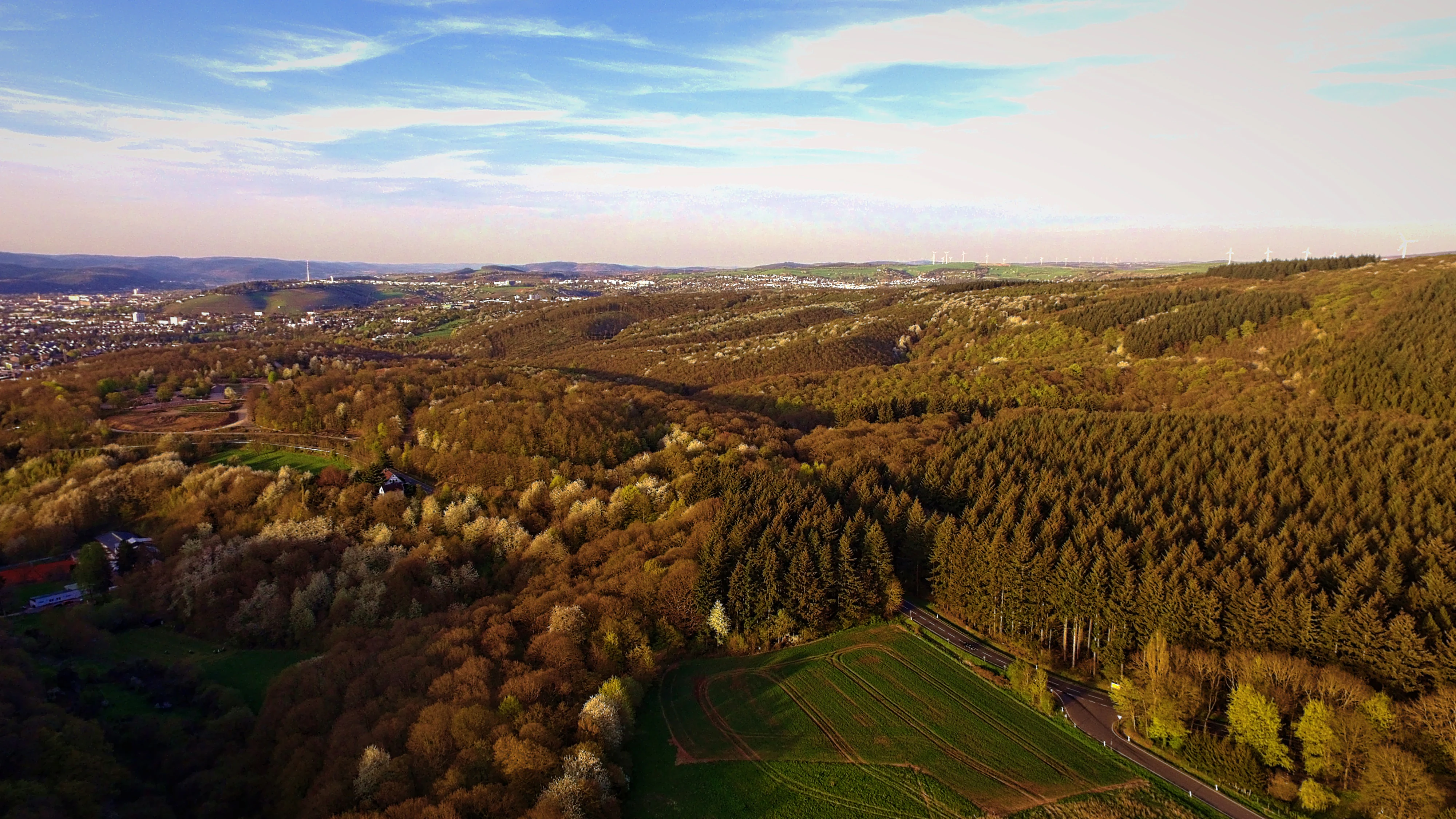
An elevated landscape view of a vast forest area with mixed deciduous and coniferous trees, showing open fields and a distant town horizon under a clear sky.
An aerial view of the Mattheiser Wald nature reserve, showcasing the extensive forest landscape near Trier.

Mattheiser Wald history and protected-area timeline

The Mattheiser Wald originally belonged to the landholdings of the nearby Abbey of St. Eucharius, St. Matthias, a Benedictine monastery south of Trier. After secularization, the forest was repeatedly used as a military training area, and during the Cold War it hosted a special weapons depot under French guard known as the "Sonderwaffenlager Mattheiser Wald."

From around 1938 the property formed part of the Kaserne Feyen, also referred to later as the Castelnau-Kaserne, and was used as an exercise ground for the garrison. For approximately sixty years the area remained largely closed to the public and was only minimally managed for forestry. After the withdrawal of French forces in 1999, both the barracks and the surrounding training area became available for new civilian use, prompting a wider discussion about the future of the site.

The move toward conservation began with an informal commitment in 2001 from SGD Nord, the regional structural and approval directorate, to designate the forest as a nature reserve. A written confirmation followed in October 2002, and in August 2003 the city of Trier and Rhineland-Palatinate officially placed approximately 447 hectares of the Mattheiser Wald under protection. In 2004 the area was additionally recognized as a European Fauna-Flora-Habitat site, integrating it into the Natura 2000 network.

A local support association ("Förderverein Mattheiser Wald") was founded in May 2004 to promote public understanding of the reserve's flora and fauna and to advocate for its protection. The association played a notable role in opposing plans to build a commercial trade park adjacent to the nature reserve, and after its conservation goals were achieved, the association dissolved in 2008.

Mattheiser Wald landscape and geographic character

The landscape of Mattheiser Wald is defined by a broad forested valley system on the southern outskirts of Trier. The reserve follows the course of the Aulbach stream through a gently incised valley and extends across the slopes and hills running southeastward to the Kandelbach. This topography creates a varied terrain of shaded valley bottoms, mid-slope woodland, and more exposed ridges.

Throughout the area, traces of the long military use remain clearly visible. Former shooting ranges, training obstacles, track systems built for armored vehicles, and compacted open sections interrupt the forest cover and create the open-ground features that today form a critical part of the reserve's habitat structure. Together with small ponds and damp hollows, these features produce a mosaic of dry, moist, shaded, and open microhabitats within a relatively compact area.

The vegetation is dominated structurally by an oak and hornbeam mixed forest with a notable share of old and over-mature trees. Sections of the woodland retain the character of a historical "Mittelwald," or coppice-with-standards, in which lower stories were regularly cut back for bark and firewood while older standards were preserved.
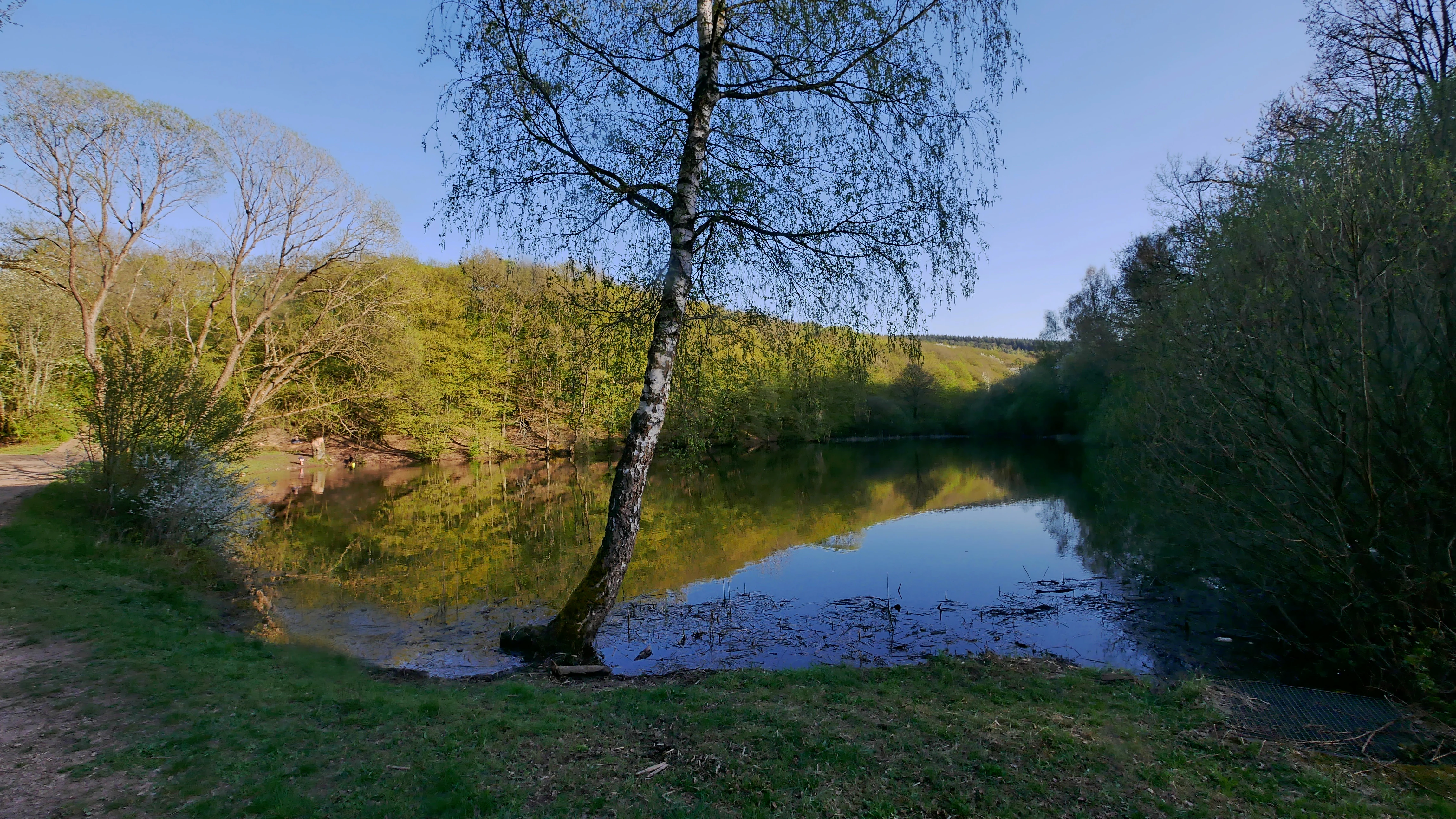
A peaceful pond surrounded by trees and green vegetation in the Mattheiser Wald nature reserve, with a thin tree standing prominently in the foreground near the water edge.
The Pfahlweiher pond, a tranquil feature within the Mattheiser Wald nature reserve.

Mattheiser Wald ecosystems, habitats, and plant life

Ecologically, Mattheiser Wald belongs to the oak-hornbeam forest zone typical of the lowland and hill country of the Mosel region, but its habitat diversity has been amplified by past disturbance regimes. The forest includes substantial areas of old-growth oak and hornbeam with high volumes of standing and fallen deadwood, which support saproxylic insects and specialist woodland species.

Alongside the closed forest, the reserve contains a network of open and semi-open habitats. Pools and pond-like depressions, some of which originated as features of the military terrain, are scattered through the landscape and support amphibians and aquatic invertebrates. Open clearings, dry grasslands, and disturbed ground host a different community of plants and invertebrates that depend on periodic disturbance.

Maintaining this disruption-dependent open habitat requires active management. Sheep and goats are used to graze clearings and prevent natural reforestation, and where grazing is insufficient, mechanical clearance is applied. Historical woodland management practices are also continued in parts of the reserve through periodic coppicing cycles, preserving the structural features of the traditional coppice-with-standards system.

Mattheiser Wald wildlife and species highlights

The wildlife interest of Mattheiser Wald reflects the combination of mature broadleaf forest, ponds, and disturbance-maintained open areas. Among the most characteristic species are the yellow-bellied toad, which uses the reserve's ponds as breeding habitat, and the crested newt, recorded in the area's wetland features. Snake species such as the smooth snake are present, and the wildcat is noted among the larger mammals.

Bat diversity is a particular feature, with several species using the forest as both roosting and hunting habitat, exploiting the structural complexity of the old trees along with the open and edge habitats. The woodland also supports black woodpecker and middle spotted woodpecker, both indicators of mature deciduous forest with sufficient deadwood.

On the invertebrate side, the reserve is notable for longhorn beetles associated with old broadleaf trees and for the swallowtail butterfly. Plant interest includes the colorful forget-me-not Myosotis discolor and the grass Vulpia bromoides, both rare species tied to open and disturbed ground. Together these plants and animals give the reserve a conservation profile that extends well beyond a typical urban forest.

Mattheiser Wald conservation status and protection priorities

Mattheiser Wald carries both national and European conservation designations. As a registered nature reserve under Rhineland-Palatinate law, it is protected for its habitat structures, rare species, and ecological functions. Its parallel recognition as a Fauna-Flora-Habitat site under the European Union Habitats Directive places it within the Natura 2000 network and binds it to specific conservation objectives for habitat types and species listed under the directive.

The conservation significance of the site is rooted in the unusual combination of an old, structurally rich broadleaf forest and a network of disturbance-dependent open habitats concentrated within a single urban-edge landscape. The long period of restricted access during the military era effectively shielded the forest from intensive timber harvesting and heavy public use, allowing old trees, deadwood, and traditional woodland structures to persist. At the same time, the disturbance legacies of military activity created pools, compacted clearings, and open ground that now support species that would otherwise be poorly represented in the surrounding region.

Active management is essential to maintain the reserve's open-ground features, which would otherwise revert to closed forest. Grazing by sheep and goats, mechanical clearance where needed, and continuation of historical coppicing cycles for selected areas are all part of the conservation strategy. Local advocacy, especially through the short-lived Förderverein Mattheiser Wald, played an important role in shaping the reserve's boundaries and protecting it from adjacent development pressures.

Mattheiser Wald cultural meaning and human context

The cultural history of Mattheiser Wald is closely tied to monastic landownership and to the long military history of the Trier region. The forest's origins as part of the estates of the Benedictine Abbey of St. Eucharius, St. Matthias connect it to one of the most significant monastic sites in the Mosel valley. After secularization, the forest's identity shifted to that of a military landscape, used successively for training by several eras of armed forces and most recently shaped by decades of French military presence.

The Cold War period added a distinctive layer to that military history with the Sonderwaffenlager, a special weapons depot situated within the forest under French guard. After the 1999 withdrawal of French forces, the area underwent a process of conversion ("Konversion") from military to civilian use that affected not only the barracks but also the surrounding training ground, which eventually became the present-day nature reserve.

In the contemporary period, Mattheiser Wald has become a defining element of local identity for the adjacent Trier neighborhoods, functioning both as a green-space counterpoint to the urban environment and as a working cultural landscape where traditional woodland practices and modern conservation coexist.

Top sights and standout views in Mattheiser Wald

Mattheiser Wald stands out as one of the largest and most ecologically valuable urban-adjacent nature reserves in the Trier region, with a forest character shaped by six decades of restricted military access. Its combination of old-growth oak-hornbeam woodland and disturbance-maintained open habitats is unusual for a site within a German city limits.

Key highlights include the European FFH designation, the structural richness of the forest with abundant old trees and deadwood, a network of ponds and clearings that support rare amphibians and bats, and the historical "Mittelwald" management that continues in selected sections of the reserve.

Best time to visit Mattheiser Wald

Mattheiser Wald can be visited throughout the year, with the character of a visit shifting with the seasons. Spring brings renewed growth in the herb layer, amphibian activity around the reserve's ponds, and increasing bird song in the maturing broadleaf canopy. Summer offers dense, shaded forest conditions and full floral display in the clearings and along paths.

Autumn is typically the season when the structural richness of the oak-hornbeam forest becomes most visible, with fallen leaves, fungi, and the visible grain of old trees standing out along trails. Winter visits are quieter and emphasize the reserve's topography, the network of paths, and the openness of the grazed clearings when the vegetation has died back. Because the reserve sits within the city limits of Trier, conditions underfoot and the visibility of disturbance features remain broadly accessible year-round.

Monthly climate preview

Measured monthly temperature and precipitation rhythms across the protected area

Mattheiser Wald Climate Normals and Long Term Temperature Patterns

Long term data samples reveal significant annual temperature shifts alongside steady precipitation distribution across the representative park coordinate. Examining the complete monthly climate profile provides deeper context for analyzing environmental conditions throughout the protected landscape.
Annual mean9 °C
0 °C19 °C
Jan
Feb
Mar
Apr
May12°
Jun16°
Jul19°
Aug18°
Sep14°
Oct
Nov
Dec
Warmest month
July

18.6 °C

Coolest month
January

-0.2 °C

Wettest month
December

2.9 mm/day

Driest month
April

1.7 mm/day

Park location guide

Geography guide, regional context, and park location map for Mattheiser Wald

Mattheiser Wald park geography, regions, and map view in Germany

Understand where Mattheiser Wald sits in Germany through a broader geographic reading of the surrounding landscape, nearby location context, and its mapped position within the national park landscape.

How Mattheiser Wald fits into Germany

Germany is a federal republic in Western and Central Europe with a population of over 83 million across sixteen constituent states. It is Europe's largest economy by nominal GDP and a major global exporter and importer. The capital is Berlin, and the country borders Denmark, Poland, Czech Republic, Austria, Switzerland, France, Luxembourg, Belgium, and the Netherlands.

Wider geography shaping Mattheiser Wald in Germany

Germany is located in Western and Central Europe, spanning 357,022 km². It borders Denmark to the north, Poland and the Czech Republic to the east, Austria and Switzerland to the south, and France, Luxembourg, Belgium, and the Netherlands to the west. The country has coastlines on the Baltic Sea and North Sea to the north, with the Alps located in the southern region.

Map view of Mattheiser Wald

Use this park location map to pinpoint Mattheiser Wald in Germany, understand its exact geographic position, and read its mapped placement within the surrounding landscape more clearly.

Pigeon | © OpenStreetMap contributors

Location context for Mattheiser Wald

Rhineland-Palatinate
Recorded earthquake history

Review the Historical Earthquake Catalogue for Mattheiser Wald

Explore the structured record of seismic events associated with the location of Mattheiser Wald. This MoriAtlas resource presents historical magnitude, depth, and distance data, offering a transparent view of the seismic history recorded around this protected nature reserve.

Mattheiser Wald Earthquake History

Catalogued events

152 events

Strongest magnitude

Magnitude 4.5

Most recent event

Sep 28, 2008

This history includes earthquakes recorded inside the park or within 50 km of its borders

Explore detailed visual records of old-growth oak hornbeam woodlands and valley terrain.

Mattheiser Wald Photos and Scenery: Visualizing the Protected Forest Landscape

Visual records illustrate the protected forest environment, old-growth oak and hornbeam stands, and varied valley terrain of Mattheiser Wald. Examining these detailed landscape photographs helps researchers understand the rare habitats and ecological structure preserved within this urban nature reserve.

An elevated landscape view of a vast forest area with mixed deciduous and coniferous trees, showing open fields and a distant town horizon under a clear sky.

A calm, reflective pond surrounded by dense, green deciduous forest on a sunny day.

A peaceful pond surrounded by trees and green vegetation in the Mattheiser Wald nature reserve, with a thin tree standing prominently in the foreground near the water edge.

Park atlas

Compare nearby regional nature reserves and connected woodland habitats

Parks Near Mattheiser Wald and Surrounding Protected Areas

Browse other protected areas near Mattheiser Wald to examine similar urban forest reserves and valley ecosystems across the surrounding region. Extending the geographic comparison reveals broader regional conservation patterns and connected woodland terrain.
Nature reserveRhineland-Palatinate
About 4.9 km away#1 closest

Southwest

Wiltinger Saarbogen: Mapping the Natural Saar River Meander and Floodplain Habitats

A critical protected nature reserve in the Rhineland-Palatinate river landscape.

Wiltinger Saarbogen remains a rare, natural river arc within the Saar valley. This protected area offers a deep look into riverine geography, featuring a concentrated mosaic of gravel banks, reed-fringed wetlands, and riparian forests that stand in contrast to the engineered shipping canals of the region.

Area
1.67 km²
Established
1997
A minimalist watercolor painting featuring soft, abstract layers of green hills, purple distant ridges, and a pale yellow sky against a white background.
Nature reserveRheinland-Pfalz
About 5.5 km away#2 closest

Northwest

Gillenbachtal Nature Reserve: Geography and Protected Woodland Boundaries in Rheinland-Pfalz

A rare forest gorge and orchid habitat near the city of Trier.

Trace the boundaries and ecological features of Gillenbachtal, a designated nature reserve characterized by its steep-sided forest gorge and varied microclimates. This area serves as a critical protected enclave featuring deadwood habitats, limestone outcrops, and traditional orchard meadows that contrast with the urban development of nearby Trier.

Area
38.49 km²
Established
1995
Watercolor painting of a green, rolling hillside landscape with faint pink floral details in the foreground.
Nature reserveRheinland-Pfalz
About 7.4 km away#3 closest

West

Perfeist bei Wasserliesch: Protected Grassland and Botanical Mapping in Rheinland-Pfalz

A regional sanctuary for rare orchids and calcareous meadow flora.

Perfeist bei Wasserliesch represents a significant protected area within the German Moselle landscape. Spanning 22 hectares of dry, sun-exposed calcareous soil on the Liescher Berg, the reserve offers a focused look at open grassland ecology. Its unique status as a botanical reference point highlights how small-scale protected land maintains rare plant species and fragile meadow habitats against the backdrop of the surrounding Moselle valley hill country.

Area
0.22 km²
Established
1986
Nature reserveRheinland-Pfalz
About 14 km away#4 closest

Southwest

Langheck bei Nittel Nature Reserve: A Detailed Atlas of Protected Moselle Landscapes

Ecological geography and calcareous grassland habitat in Rheinland-Pfalz

Langheck bei Nittel is a significant nature reserve located in the Upper Moselle valley of Germany. The site protects a rare mosaic of calcareous dry grasslands, shrubbery, and forest edges that host a high concentration of orchid species. As a critical component of the regional biotope network, it offers insight into the conservation of warm-loving flora and the management of stony, nutrient-poor landscapes.

Area
0.42 km²
Established
1998
A soft watercolor painting of a landscape featuring a small river or pond in the center, flanked by green trees on the left and pink-flowered trees on the right, with low hills in the distance.
Nature reserveLuxembourg
About 16 km away#5 closest

West

Naturschutzgebitt Kelsbaach Nature Reserve: A Geographical Overview of Luxembourg Landscapes

Dolomite rock formations and protected dry grassland ecosystems

Naturschutzgebitt Kelsbaach preserves a distinctive environmental gradient across the Moselle valley hillsides in Luxembourg. From exposed dolomite cliffs and arid plateau grasslands to the shaded Kelsbaach stream gorge, the reserve illustrates the complex interplay of regional geology and microclimate. This protected area offers a precise look at local biodiversity habitats and the lasting impact of historical land use on the natural terrain.

Area
0.755 km²
Established
1998
Relief
Upland
Climate
Temperate
Watercolor illustration of a lush wetland landscape with reed beds, rolling green hills, and soft pastel colors.
Nature reserveRheinland-Pfalz
About 16 km away#6 closest

Northeast

Ried am Föhrenbach Nature Reserve: Geographic Overview and Protected Wetland Boundaries

Wetland mosaic and reedbed landscape in Rhineland-Palatinate

The Ried am Föhrenbach nature reserve in Rhineland-Palatinate encompasses a unique, elongated strip of wetland terrain along the Föhrenbach stream. Known for its extensive common reed stands and moist grassland, this protected area acts as a vital environmental buffer and habitat refuge within the regional landscape, set against the backdrop of the Moselle hill country and major transport infrastructure.

Area
0.465 km²
Established
1991
Relief
Lowland
Scope
Terrestrial
Watercolor painting of a rolling forested landscape with soft pink and yellow sky.
Protected areaGermany
About 17 km away#7 closest

Northeast

Meulenwald Protected Landscape: Topography and Geographic Context in the Eifel

A sandstone forest range and regional ecological landmark.

The Meulenwald offers a unique study in forest geography, spanning from the dense pine stands in the south to the varied shrubby clearings of the northern Heckenland. As a protected area near Trier, it showcases a remarkable botanical collection alongside a complex network of streams and ridges shaped by red sandstone, marking its status as a vital recreational and ecological anchor within Rhineland-Palatinate.

Nature reserveSaarland
18 km away#8 closest

South

Steilhänge der Saar Nature Reserve: Mapped Protected Landscapes and River Valley Geography

Protected river slopes and forested terrain in Saarland

The Steilhänge der Saar nature reserve encompasses steep, wooded hillsides rising above the Saar river valley. This consolidated protected area features complex ecological gradients between rocky, sun-exposed upper slopes and shadowed tributary streams, serving as a critical habitat zone and a defining feature of the regional Saarland landscape.

Area
10.86 km²
Established
2017
IUCN
IV

Common questions about visiting, size, designation, and location context for Mattheiser Wald

Mattheiser Wald FAQs for park facts, access, geography, and protected area context

Find quick answers about Mattheiser Wald, including protected-area facts, park geography, trail and visitor context, and how the park fits into its surrounding country and regional landscape.
MoriAtlas Explorer

Continue Your Protected Areas Search Across the Global Atlas

Deepen your exploration by continuing the structured search for national parks and protected areas worldwide. Utilize the comprehensive filtering capabilities to compare different conservation landscapes and refine your understanding of global park geography. Discover more about the distribution and characteristics of protected natural areas.

Global natural geography