
Mori Atlas logo
Protected areaMawson's Huts

Investigating the architectural remnants and wind-scoured coastal terrain of a polar heritage site.

Mawson's Huts Protected Area: Exploring the Historic Geography of Cape Denison, Antarctica

(Mawson's Huts Historic Site)

Mawson's Huts stands as a remote protected landscape at Cape Denison, located within the harsh geographic boundaries of the Australian Antarctic Territory. This historic site features a cluster of prefabricated timber buildings that remain as tangible markers of early twentieth-century polar scientific exploration. The surrounding terrain of ice-scoured rock and persistent coastal winds provides a stark, frozen context for these preserved structures.

Antarctic heritageHeroic Age of explorationHistoric Site and MonumentAntarctic Treaty siteExpedition buildingsCape Denison
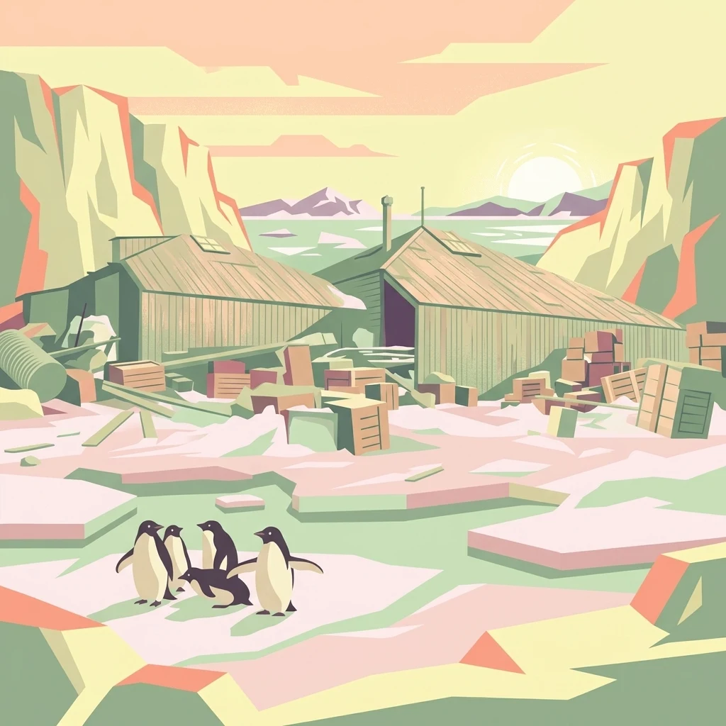
A stylized flat-design illustration of historic wooden expedition buildings with stacks of crates outside, set in a snowy landscape with a small group of penguins in the foreground and a pale sun on the horizon.

Mawson's Huts

Protected area

Park overview

Structured park overview, official facts, and landscape profile for Mawson's Huts

Mawson's Huts park facts, protected area profile, and essential visitor context

Review the core facts for Mawson's Huts, including designation, size, terrain, visitor scale, habitats, and operating context in one park-focused overview.

About Mawson's Huts

Mawson's Huts is a tightly grouped set of expedition buildings at Cape Denison, on the coast of George V Land in the eastern Australian Antarctic Territory. The site lies far to the south of Hobart, Tasmania, in a region notorious for severe weather, where the coastline has long been studied as one of the windiest places on Earth. The buildings were erected for the Australasian Antarctic Expedition of 1911 to 1914, the first polar expedition to be conceived, funded and largely staffed from Australia rather than from the traditional European hub of polar science.

The defining structure is the timber-framed winter quarters, the building usually referred to simply as Mawson's Hut. With its distinctively steep pyramid roof, this hut combined living quarters and a workshop, both components prefabricated in Sydney and Melbourne and shipped south for assembly. Inside, the men of the main base shared a kitchen, a laundry, storage space and a sleeping room, underlining how compressed life was within a footprint of only a few dozen square metres. Verandas ran around three sides of the building and served many purposes, including sheltering the sled dog teams that were essential to the expedition's overland and coastal work.

Beyond the main hut, the Mawson's Huts complex includes purpose-built scientific structures: a magnetograph hut for tracking variations in Earth's south magnetic pole, an absolute magnetic hut serving as a reference station for those measurements, and a transit hut functioning as an astronomical observatory. These buildings reflect the unusually broad scientific programme Mawson planned for the expedition, spanning geomagnetism, meteorology, geography and astronomy, all carried out from a single remote coastal outpost.

A defining technological milestone associated with the huts is the first use of radio on the Antarctic continent. Through a wireless relay station established on Macquarie Island, AAE personnel could communicate with the Australian mainland and, crucially, transmit weather observations continuously back home. This made Mawson's Huts not only a physical survival site from the Heroic Era but also the birthplace of routine Antarctic radio communications, a precedent that shaped later polar science logistics.

Today, Mawson's Huts is valued less as a functioning base and more as a heritage site of exceptional authenticity. The buildings still stand, their interiors still holding the imprint of the men who lived and worked there more than a century ago. Conservation programmes run by the Australian Antarctic Division and the Mawson's Huts Foundation have worked to slow deterioration of the timber, manage snow accumulation and document the site archaeologically. Their efforts, alongside the site's inclusion in multiple heritage registers, sustain Mawson's Huts as a tangible, place-based record of Australia's foundational contribution to Antarctic exploration.

Quick facts and research context for Mawson's Huts

Mawson's Huts stands at Cape Denison on the coast of George V Land in the Australian Antarctic Territory, in one of the windiest stretches of coastline on the continent. The site was established in 1912 for the Australasian Antarctic Expedition led by Sir Douglas Mawson, making it the only Heroic Era Antarctic base that was primarily an Australian undertaking. The huts are protected under the Antarctic Treaty as Historic Site and Monument 77, sit within Antarctic Specially Protected Area 162 and Antarctic Specially Managed Area 3, and are listed on the Australian National Heritage List and Commonwealth Heritage List. They are maintained through ongoing collaboration between the Australian Antarctic Division and the private Mawson's Huts Foundation, with significant conservation work carried out in the late twentieth and early twenty-first centuries.

Protection and recognition

Documented terrestrial protection scope, designation timeline, and recognition context

Mawson's Huts Protection Status and Historical Designation Records

Mawson's Huts maintains a documented terrestrial protection status established in nineteen seventy two. Historical designation records provide structured oversight details for conservation monitoring and regional landscape analysis.

Protection details

Protection scope
Terrestrial
Designated year
1972
Transboundary protection
No
Park context

Deeper park guide and search-rich context for Mawson's Huts

Mawson's Huts history, landscape, wildlife, and travel context

Explore Mawson's Huts through its history, landscape character, ecosystems, wildlife, conservation priorities, cultural context, and seasonal travel timing in a structured park guide built for atlas discovery and search intent.

Why Mawson's Huts stands out

Mawson's Huts is best known as one of the last intact buildings from Antarctica's Heroic Era of exploration and as the principal Australian-built legacy of early twentieth-century polar science. The site combines a compact, prefabricated living hut with purpose-built magnetic and astronomical observatories, all preserved at a famously wind-exposed location. It is also recognised for pioneering the first use of radio on the Antarctic continent, through a relay link via Macquarie Island that allowed continuous transmission of meteorological observations back to Australia. Together, these qualities make the huts a uniquely accessible, above-ground time capsule of the 1911 to 1914 Australasian Antarctic Expedition.
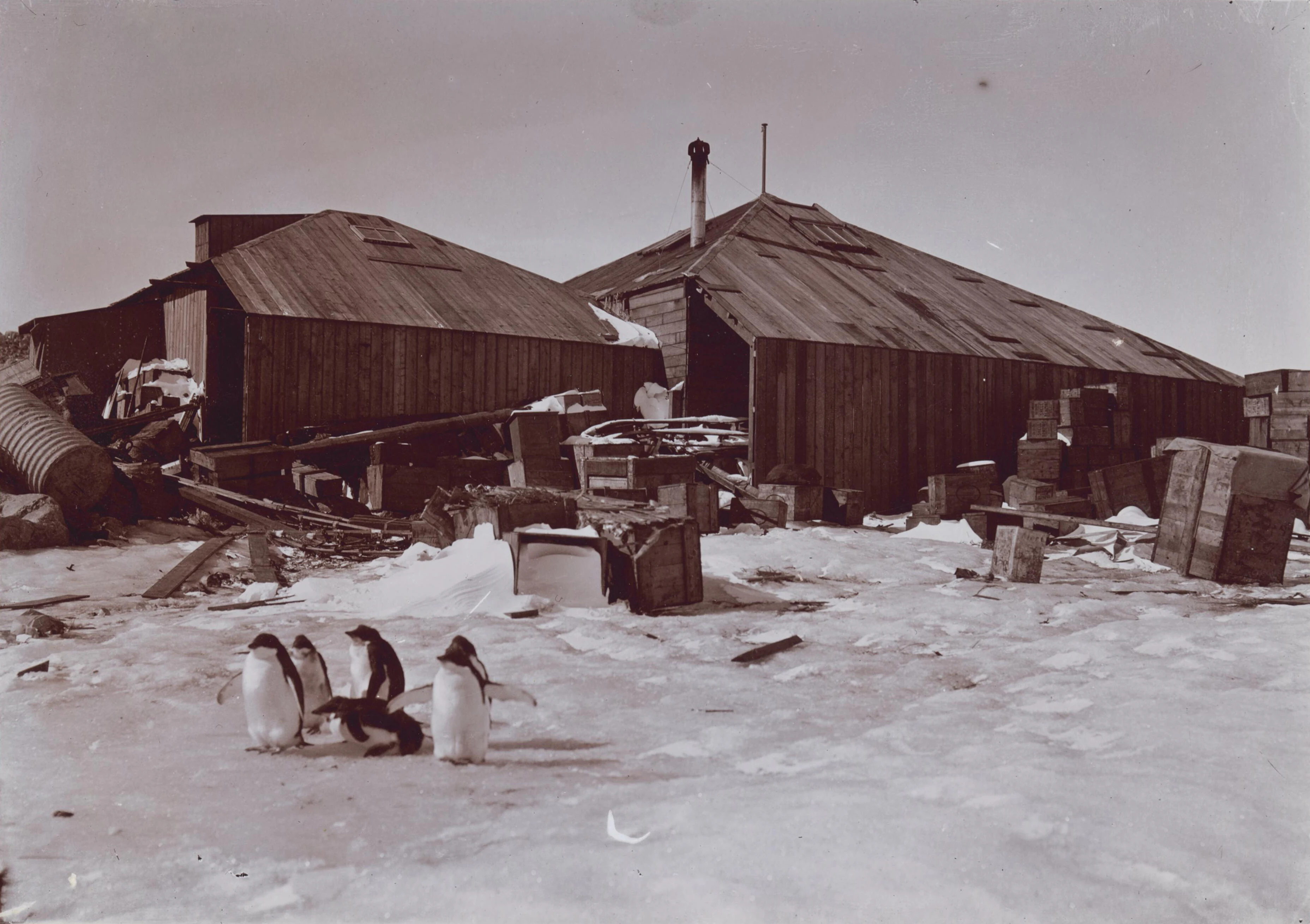
Historical black and white photograph of wooden, corrugated iron-roofed huts in a snowy Antarctic environment, with a small group of penguins standing in the foreground.
The main base at Mawson's Huts, as captured during the Australasian Antarctic Expedition, circa 1911.

Mawson's Huts history and protected-area timeline

Mawson's Huts came into being as part of the Australasian Antarctic Expedition, the first major Antarctic expedition organised and led from Australia. The expedition set out under Sir Douglas Mawson in 1911 and returned in 1914, with the buildings at Cape Denison raised in 1912 for use as the main base. Eighteen men occupied the huts during the first winter, and a smaller party of seven, including Mawson himself, remained through a second, unplanned year in 1913 after the relief ship was unable to reach the base.

For decades after the expedition, the huts were largely left to the Antarctic environment, visited only sporadically. Sustained attention began in the late 1970s with the involvement of the Australian Antarctic Division. The two Project Blizzard expeditions of 1984 to 1985 and 1985 to 1986 marked intensive early conservation campaigns, supported later by the founding of the Mawson's Huts Foundation in 1997, a private non-profit dedicated to ongoing preservation.

Heritage recognition followed in stages. In 1972 the site was designated as Historic Site and Monument 77 under the Antarctic Treaty, and in 2004 it was placed within Antarctic Specially Protected Area 162 and Antarctic Specially Managed Area 3. In 2005 Mawson's Huts was added to the Australian National Heritage List, complementing its inclusion on the Commonwealth Heritage List and, historically, the Register of the National Estate. A new management plan was released for public comment in 2007, framed around the heritage significance of the site in the lead-up to the AAE centenary.

Major physical interventions have included archaeological recording, internal snow removal and structural consolidation. In 1998 and again in 2006, conservation teams encapsulated the deteriorating timber roofs of the main hut with new timber over-cladding, providing critical weatherproofing for the original fabric. The Mawson's Huts Replica Museum, opened on the Hobart waterfront in 2013, extends this heritage work by recreating the appearance of the hut for visitors who will never reach Cape Denison.

Mawson's Huts landscape and geographic character

Cape Denison sits within George V Land on the coast of East Antarctica, in a stretch of polar coastline characterised by exposed rock, persistent sea ice and notoriously violent weather. The site lies in one of the windiest regions on the continent, with wind conditions so severe that the area has long been used as a benchmark for polar weather studies. The terrain around the huts is rocky and ice-scoured, with the buildings themselves perched close to the shoreline.

The visual contrast between the comparatively small timber huts and the vast white expanse of the surrounding coast is central to the site's character. Despite their modest dimensions, the huts have endured because of the careful construction of their frames and roofs, although the unforgiving climate continues to drive conservation challenges, including ice loading, snow infiltration and deterioration of exposed timber.

Mawson's Huts ecosystems, habitats, and plant life

The natural setting of Mawson's Huts is among the harshest terrestrial and marine environments on Earth. Cape Denison is surrounded by the Southern Ocean and its seasonal pack ice, supporting one of the most productive polar marine ecosystems anywhere. The nearby rocky headlands and ice-free areas around the cape are visited by seals, penguins and a wide range of seabirds that depend on the surrounding waters for food.

Vegetation in the immediate vicinity of the huts is limited to the sparse and specialised flora typical of Antarctic Specially Managed Area conditions, with lichen and moss communities occupying the limited exposed rock. The wider environment is shaped by extreme cold, prolonged darkness in winter and intense katabatic winds, all of which contribute to a relatively austere but ecologically significant setting that supports ongoing scientific monitoring alongside heritage preservation.

Mawson's Huts wildlife and species highlights

Wildlife at and around Mawson's Huts is dominated by species adapted to one of the windiest coastal stretches in Antarctica. The waters offshore and the ice edge support seal populations, while penguin colonies and other seabirds use the headlands and nearby islands for breeding and roosting. The huts also preserve a notable historical relationship with Antarctic fauna: the sled dog teams that once lived under the main hut's verandas were an integral part of the original expedition's working life.

Today, the site continues to support polar biological research. The presence of intact, century-old structures alongside an undisturbed wildlife-rich environment makes Cape Denison a rare example of a polar heritage site where conservation of the built fabric and the surrounding ecosystem must be managed together.

Mawson's Huts conservation status and protection priorities

Mawson's Huts is protected under multiple overlapping frameworks that recognise both its Antarctic Treaty status and its Australian heritage significance. Since 1972 it has been listed as Historic Site and Monument 77 under the Antarctic Treaty, the international mechanism that governs the continent. In 2004 it became part of Antarctic Specially Protected Area 162, embedded within the broader Antarctic Specially Managed Area 3, giving it layered protection for both the buildings and the surrounding environment.

At the national level, the site is on the Australian National Heritage List and the Commonwealth Heritage List, and historically also featured on the Register of the National Estate. Management is shared between the Australian Antarctic Division, which undertakes official research and field work, and the Mawson's Huts Foundation, a non-profit that has coordinated private conservation campaigns since 1997. Major interventions have focused on stabilising the timber structure of the main hut, removing internal snow and documenting the archaeological record, with the goal of preserving as much original fabric as possible for the centenary and beyond.

Mawson's Huts cultural meaning and human context

Mawson's Huts occupies a central place in Australia's identity as a polar nation. The Australasian Antarctic Expedition was the first major Antarctic venture planned, funded and led from Australia, and Mawson's Huts is its most tangible surviving monument. The site's continued preservation, including the creation of a full-scale replica on the Hobart waterfront near the wharf once used by SY Aurora, reflects an enduring public interest in Mawson's story and in the broader narrative of Australian exploration.

The huts also carry a more sombre cultural layer. The expedition was marked by loss, including the deaths of two members of Mawson's eastern sledging party, and the site has acquired an additional resonance as a memorial landscape, in addition to its role as a record of scientific endeavour.

Top sights and standout views in Mawson's Huts

Mawson's Huts offers several distinguishing features: it is one of only six surviving Heroic Era Antarctic sites, and the only one from that era led and staffed primarily by Australians. The compact, prefabricated main hut combines living quarters and workshop within a footprint of roughly 80 square metres, yet supported eighteen men through a full Antarctic winter. The associated magnetograph, absolute magnetic and transit huts demonstrate the expedition's unusually broad scientific ambitions.

The site's pioneering role in Antarctic radio communications, through the Macquarie Island relay, gives it a unique place in the history of polar science logistics. Layered heritage protections, including Antarctic Treaty listing, ASPA / ASMA status and Australian national heritage recognition, ensure that this combination of architectural survival, scientific legacy and historical resonance continues to be actively preserved.

Best time to visit Mawson's Huts

Mawson's Huts lies in East Antarctica and can only realistically be reached by ship during the austral summer, when sea ice conditions are most favourable for expedition vessels departing from Hobart or New Zealand subantarctic ports. Summer visits offer the longest daylight hours, the most stable ice conditions and the most comfortable working environment for any landing parties, although weather at Cape Denison remains highly variable year-round. Outside the short summer window the area is effectively inaccessible to non-governmental visitors, and even during summer any actual visit depends heavily on annual ice and weather conditions.


Monthly climate preview

Monthly temperature ranges and precipitation patterns for Mawson's Huts

Mawson's Huts Climate Normals, Annual Temperature and Precipitation Rhythm

Historical climate data from 1991 to 2020 records long-term average monthly temperatures and precipitation rates at a representative coordinate within Mawson's Huts. Examining the complete twelve-month sequence reveals detailed thermal swings across every calendar period.
Annual mean-18 °C
-24 °C-7 °C
Jan-7°
Feb-11°
Mar-17°
Apr-21°
May-23°
Jun-24°
Jul-24°
Aug-24°
Sep-23°
Oct-20°
Nov-13°
Dec-7°
Warmest month
January

-6.6 °C

Coolest month
July

-24.3 °C

Wettest month
February

2 mm/day

Driest month
November

1.1 mm/day

Park location guide

Geography guide, regional context, and park location map for Mawson's Huts

Mawson's Huts park geography, regions, and map view in Antarctica

Understand where Mawson's Huts sits in Antarctica through a broader geographic reading of the surrounding landscape, nearby location context, and its mapped position within the national park landscape.

How Mawson's Huts fits into Antarctica

Centered on the South Pole, Antarctica is the highest, driest, coldest and windiest continent. Almost all of its land is buried beneath ice, yet its coasts and surrounding ocean sustain globally significant colonies of penguins, seals and seabirds.

Wider geography shaping Mawson's Huts in Antarctica

The continent surrounds the geographic South Pole and is separated from other landmasses by the Southern Ocean. A vast ice sheet conceals mountain ranges, basins and plains, exceeds four kilometres in thickness in places and flows outward through glaciers and floating ice shelves. The Transantarctic Mountains divide East and West Antarctica, while the Antarctic Peninsula reaches north toward South America.

Map view of Mawson's Huts

Use this park location map to pinpoint Mawson's Huts in Antarctica, understand its exact geographic position, and read its mapped placement within the surrounding landscape more clearly.

Pigeon | © OpenStreetMap contributors

Location context for Mawson's Huts

Australian Antarctic Territory

Visualizing the historic protected area, terrain, and coastal Antarctic environment.

Mawson's Huts Photos and Scenery: Exploring the Polar Landscape

Visual documentation captures the remote coastal terrain, exposed rock formations, and harsh weather conditions surrounding Mawson's Huts. Studying these protected area photographs provides clear insight into the extreme polar landscape and heritage architecture preserved at Cape Denison.

Historical black and white photograph of wooden, corrugated iron-roofed huts in a snowy Antarctic environment, with a small group of penguins standing in the foreground.

A wooden, pyramid-roofed structure sitting in a vast, snow-covered landscape under a bright sky, characteristic of the historic Mawson's Huts site in Antarctica.

Park atlas

Compare surrounding polar reserves and ice-scoured coastal heritage areas

Explore Other Parks Near Mawson's Huts and Connected Protected Landscapes

Browse protected areas near Mawson's Huts to examine similar polar terrain and historic expedition bases across the region. Regional park comparison provides deeper context for understanding isolated conservation zones and extreme climate environments.
Marine protected areaAustralia
About 1,247 km away#1 closest

Northeast

Macquarie Island Marine Park: Subantarctic Seafloor and Marine Conservation Geography

A remote Australian marine protected area and ocean atlas

This expansive marine protected area encompasses deep ocean habitats and productive surface waters in the remote subantarctic. The park features diverse seafloor topography, such as abyssal plains and submarine canyons, while providing vital foraging grounds for penguins, seals, and diverse marine wildlife across the southwest Pacific.

Area
475,465 km²
Established
1999
IUCN
IV
Relief
Lowland
Protected areaAntarctica
About 1,409 km away#2 closest

West

Clark Peninsula: Antarctic Protected Landscape and Coastal Geographic Atlas

Ice-free rocky terrain on the Budd Coast of Wilkes Land

Clark Peninsula provides a window into the unique geography of East Antarctica, featuring exposed rocky outcrops, coastal coves, and significant glacial moraines. As a dedicated protected area, the site supports long-term ecological research and provides a critical habitat for seabird colonies, offering a detailed look at the interface between continental ice and the Southern Ocean.

Area
9.4 km²
Relief
Lowland
Climate
Polar
Access
Remote access
Protected areaAntarctica
About 1,409 km away#3 closest

West

Ardery Island: Protected Coastal Geography and Antarctic Seabird Habitats

Rugged terrain and avian conservation in the Windmill Islands

Ardery Island represents a compact, rocky protected area within the Antarctic landscape. Known for its steep cliffs and essential seabird colonies, this island serves as a focal point for ecological study along the Budd Coast, offering a distinct example of high-latitude coastal geography.

Relief
Upland
Climate
Polar
Access
Remote access
Scope
Mixed
Protected areaAntarctica
About 1,426 km away#4 closest

West

Frazier Islands Protected Area: Geographic Boundaries and Antarctic Coastal Context

Rocky island terrain within the Vincennes Bay coastal region

Examine the rugged profile of the Frazier Islands, a group of three ice-free rocky outcrops rising from the Southern Ocean. Their protected status and specialized role as a rare continental seabird breeding ground offer a distinct lens into the regional geography and conservation landscapes of East Antarctica.

Relief
Lowland
Climate
Polar
Access
Remote access
Scope
Marine
Marine protected areaNew Zealand Subantarctic Islands
About 2,133 km away#5 closest

Northeast

Moutere Ihupuku / Campbell Island Marine Reserve: Protected Marine Landscape and Map

Subantarctic marine geography in the New Zealand island chain.

Moutere Ihupuku / Campbell Island Marine Reserve safeguards a remote underwater wilderness defined by its volcanic origins. From its basalt pinnacles to the vast sponge gardens and boulder fields, the reserve functions as a vital protected area for Southern Ocean biodiversity. Map the connections between these extreme coastal environments and the world's largest population of southern royal albatross residing within the New Zealand Subantarctic Islands.

Established
2014
Relief
Mixed relief
Access
Remote access
Scope
Marine
Marine protected areaTasmania
About 2,222 km away#6 closest

North

South Tasman Rise Commonwealth Marine Reserve Marine Protected Area and Geological Atlas

Deep-sea submarine landscapes and Australian offshore geography.

The South Tasman Rise Commonwealth Marine Reserve represents a vital offshore protected area, defined by its remote location and significant deep-sea geological features. Users can examine the reserve's unique bathymetry, including the distinctive truncated peaks of submerged seamounts and broad submarine plateaus that characterize this southern marine frontier far beyond the continental shelf.

Area
27,704 km²
Established
2007
IUCN
VI
Climate
Subpolar
Marine protected areaNew Zealand
About 2,232 km away#7 closest

Northeast

Auckland Islands Marine Mammal Sanctuary: Subantarctic Protected Area and Marine Geography

Mapping remote marine mammal habitats in the New Zealand southern Pacific

Covering over half a million hectares of oceanic terrain, the Auckland Islands Marine Mammal Sanctuary acts as a cornerstone of New Zealand conservation. The area protects complex underwater ecosystems, ranging from sheltered fjord-like inlets to deep-sea abyssal zones, while providing a stable recovery environment for vulnerable whale and sea lion populations in the subantarctic region.

Area
5,605.64 km²
Established
1993
Climate
Subpolar
Access
Highly restricted
Nature reserveNew Zealand
About 2,236 km away#8 closest

Northeast

Auckland Islands: Protected Subantarctic Geography and Volcanic Archipelago Map

An uninhabited island wilderness and nature reserve in southern New Zealand.

The Auckland Islands comprise a rugged, uninhabited volcanic archipelago south of New Zealand. This expansive nature reserve features deeply indented coastlines, sheltered harbours like Carnley Harbour, and complex subantarctic ecosystems. Gain detailed insights into this protected marine and land sanctuary, home to vital seabird colonies, endemic wildlife, and significant southern right whale gathering grounds.

Area
570 km²
Relief
Mountain
Climate
Subpolar
Access
Highly restricted

Common questions about visiting, size, designation, and location context for Mawson's Huts

Mawson's Huts FAQs for park facts, access, geography, and protected area context

Find quick answers about Mawson's Huts, including protected-area facts, park geography, trail and visitor context, and how the park fits into its surrounding country and regional landscape.
MoriAtlas Explorer

Continue Your Protected Areas Search Across the Global Atlas

Deepen your exploration by continuing the structured search for national parks and protected areas worldwide. Utilize the comprehensive filtering capabilities to compare different conservation landscapes and refine your understanding of global park geography. Discover more about the distribution and characteristics of protected natural areas.

Global natural geography
