
Mori Atlas logo
Natural monumentMedlánecké kopce

A rare urban-edge reserve preserving xerothermic vegetation and unique botanical habitats near Brno

Medlánecké kopce Natural Monument: Protected Steppe Landscapes and Rocky Terrain in Jihomoravský kraj

(Přírodní památka Medláněcké kopce)

Medlánecké kopce represents a vital natural monument situated on the northern periphery of Brno, characterized by its distinctive metabasite rock outcrops and sun-exposed slopes. This protected area supports an essential remnant of Central European steppe-like grassland, serving as a northern refuge for thermophilic flora and insect species. The landscape consists of two prominent hills that create a sharp contrast against the surrounding urban fabric of Jihomoravský kraj, maintaining ecological connectivity for rare plants and specialized wildlife.

steppe habitatdry grasslandthermophilic floraurban-edge nature reservenatural monumentBrno
A colorful digital illustration featuring a pointed green mountain with a waterfall flowing down its face, surrounded by pine forests, rolling hills, and pink-hued clouds at sunset.

Medlánecké kopce

Natural monument

Park overview

Structured park overview, official facts, and landscape profile for Medláněcké kopce

Medláněcké kopce park facts, protected area profile, and essential visitor context

Review the core facts for Medláněcké kopce, including designation, size, terrain, visitor scale, habitats, and operating context in one park-focused overview.

About Medláněcké kopce

Medláněcké kopce is a small but ecologically distinctive natural monument located in the northern part of the city of Brno, in the South Moravian Region of the Czech Republic. Although it covers slightly less than twelve hectares, the reserve is split into two separately protected areas corresponding to two hills: the smaller Medláněcký kopec in the cadastral area of Medlánky, and the larger Střelecký kopec in Královo Pole. Together they form the northern continuation of Palacký vrch and represent one of the few surviving steppe-like habitats inside or immediately adjacent to the Brno urban tissue.

The site's value comes from the unusual combination of geology, microclimate, and historical land use. The bedrock consists of metabasites of the Brno massif with granite porphyry inserts, frequently breaking through the soil surface and creating warm, dry rock outcrops. On the leeward eastern slopes, loess deposits have accumulated, giving rise to soils ranging from typical and eutrophic cambisols to rankers and loess-based luvisols. These substrates form the basis for dry, species-rich grassland and open scrub vegetation that has persisted in this part of the Brno periphery.

Because of this combination, the reserve protects a remarkable concentration of thermophilic plants and insects usually associated with warmer and more southerly regions. It is famous within Czech nature conservation as the home of Pulsatilla grandis, the large-flowered pasqueflower, while also sheltering the most northerly Czech record of the southern festoon (Zerynthia polyxena) and several other notable butterflies, reptiles, and birds. It sits among a small network of nearby protected sites, including the Medláněcká skalka nature monument to the north and the Netopýrky reserve to the west, together forming one of the most important urban-edge dry-grassland complexes in Brno.

Quick facts and research context for Medláněcké kopce

Medláněcké kopce is a Czech přírodní památka (natural monument), a protected-area category corresponding to IUCN Category IV (habitat/species management area). It sits within the statutory city of Brno, in the Jihomoravský kraj and the Brno-město district, on the cadastral territories of Medlánky and Královo Pole.

The site was formally declared on 1 January 1988. It lies at elevations between roughly 282 and 338 meters above sea level and covers about 11.82 hectares, split between the smaller Medláněcký kopec (322 m) and the larger Střelecký kopec (338 m). The protected area is a northward steppe-like extension of Palacký vrch, and its primary conservation target is a thermophilic plant and insect assemblage typical of Central European steppe habitats.

Protection and recognition

Documented terrestrial protection history established in 1988

Medlánecké kopce Protection Status and Designation History

Medlánecké kopce preserves a documented terrestrial protection status established in 1988. Official records outline the formal designation history and management scope associated with the protected landscape.

Protection details

Protection scope
Terrestrial
Designated year
1988
Transboundary protection
No
Park context

Deeper park guide and search-rich context for Medláněcké kopce

Medláněcké kopce history, landscape, wildlife, and travel context

Explore Medláněcké kopce through its history, landscape character, ecosystems, wildlife, conservation priorities, cultural context, and seasonal travel timing in a structured park guide built for atlas discovery and search intent.

Why Medláněcké kopce stands out

Medláněcké kopce is known above all for hosting one of the northernmost populations of the large-flowered pasqueflower (Pulsatilla grandis) in the Czech Republic, together with a dry, steppe-like grassland community that harbors unusually thermophilic flora and insects on the northern edge of Brno. The reserve also marks the northernmost known occurrence of the southern festoon butterfly (Zerynthia polyxena) and the northernmost known site in the country for narrow-leaved sedge (Carex stenophylla). Its other defining trait is the way it preserves dry grassland and rocky outcrops right inside a large urban area. Quartzite-like metabasite rocks of the Brno massif break through the surface, with loess on the sheltered eastern slopes, creating conditions for rare steppe species that would otherwise be associated with much warmer, more southern landscapes in Moravia or central Europe.
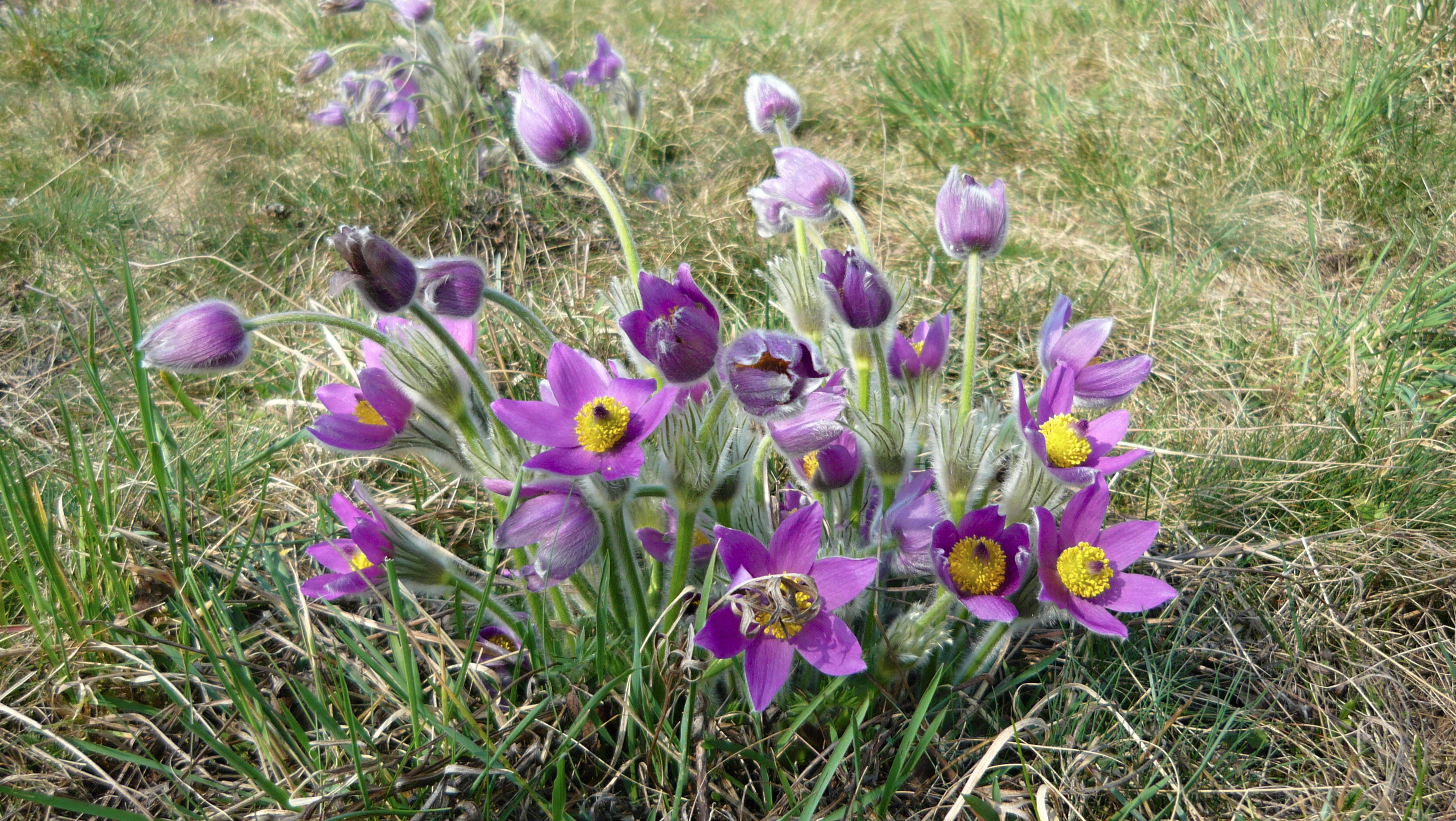
A cluster of purple, bell-shaped pasqueflower blossoms with bright yellow centers growing in dry, grassy meadow terrain.
A cluster of pasqueflowers, Pulsatilla grandis, in the steppe habitat of Medlánecké kopce.

Medláněcké kopce history and protected-area timeline

The hills that now make up Medláněcké kopce were administratively part of the Medlánky cadastral area until the 1960s, which is why both are referred to under the collective name "Medláněcké kopce" even though they now lie on different cadastral territories.

As with many European dry-grassland reserves, the biological value of these slopes is closely tied to traditional, low-intensity land use. Open rock and steppe vegetation survived precisely because the dry, shallow soils over metabasite bedrock were unsuitable for intensive agriculture, allowing a thermophilic flora and insect fauna to persist into the era of modern nature protection.

Formal protection came relatively late, in the late twentieth century, when the site was declared a přírodní památka (natural monument) on 1 January 1988. Since then it has been administered by the Jihomoravský kraj regional authority, acting through its nature conservation office, and has remained a focal site for studying the survival of steppe biota within an urbanized landscape.

Medláněcké kopce landscape and geographic character

The protected area consists of two hills rising modestly above the flat north-Brno plain. The smaller Medláněcký kopec reaches 322 meters in elevation, while the larger Střelecký kopec reaches 338 meters. Both hills have open, rocky summits and slopes with relatively shallow soils, giving them a distinctive steppe-like profile that contrasts sharply with the surrounding urban fabric of Medlánky and Královo Pole.

The underlying geology plays a decisive role in shaping this landscape. Metabasite rocks of the Brno massif, interspersed with granite porphyry, frequently break through to the surface, producing stony, sun-exposed outcrops. On the more sheltered eastern flanks, wind-deposited loess has accumulated, while the soils across the site include typical and eutrophic cambisols, rankers, and loess-based luvisols.

Because of this geological and topographic setting, the slopes retain a semi-open character with scattered shrubs, rocky patches, and herb-rich dry grassland rather than closed forest. The sky-line is broken by crags and small rock steps rather than tall trees, and from higher points the landscape opens westward and northward toward the broader Brno basin, where the reserve forms a small but very visible natural feature above the city.
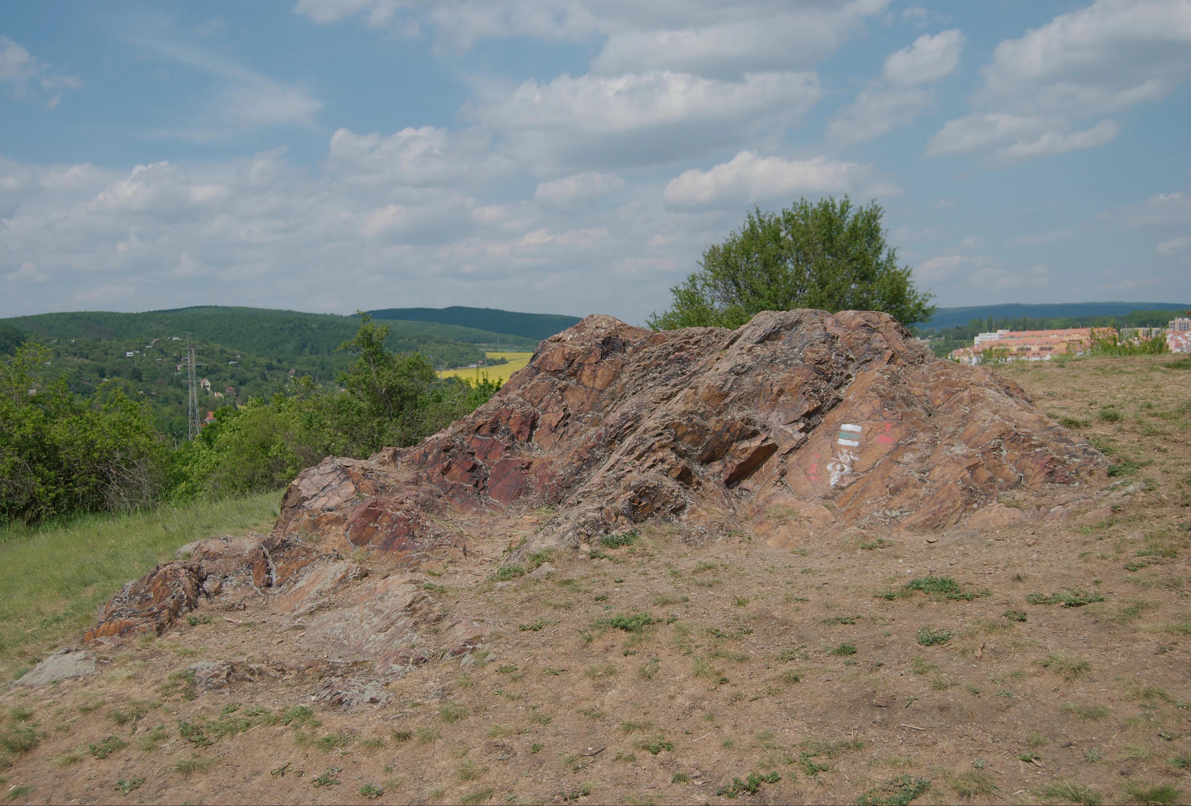
A low rocky outcrop sits on a dry, grassy hill under a partly cloudy sky, with a forest and distant town visible in the background.
A rocky outcrop at the summit of Medlánecké kopce.

Medláněcké kopce ecosystems, habitats, and plant life

Ecologically, Medláněcké kopce is a relict of the Central European steppe biome, surviving on warm, dry, and rocky substrates that would normally be associated with much more southerly landscapes. The vegetation is dominated by thermophilic dry grassland and open scrub, where exposed rock, thin soils, and a sunny, continental microclimate combine to create conditions for a distinctive plant and insect community.

The site is also part of a wider mosaic of dry habitats in this part of Brno, complementing the nearby Medláněcká skalka and Netopýrky nature monuments. The Medlánky airfield immediately south of the protected area supports an additional small population of European ground squirrels, so these hills effectively anchor a broader complex of urban-edge steppe habitat. This mosaic character means that the reserve is valuable not just in itself, but as a node within a network of dry-grassland patches that allow specialist species to persist across an otherwise heavily built-up landscape.
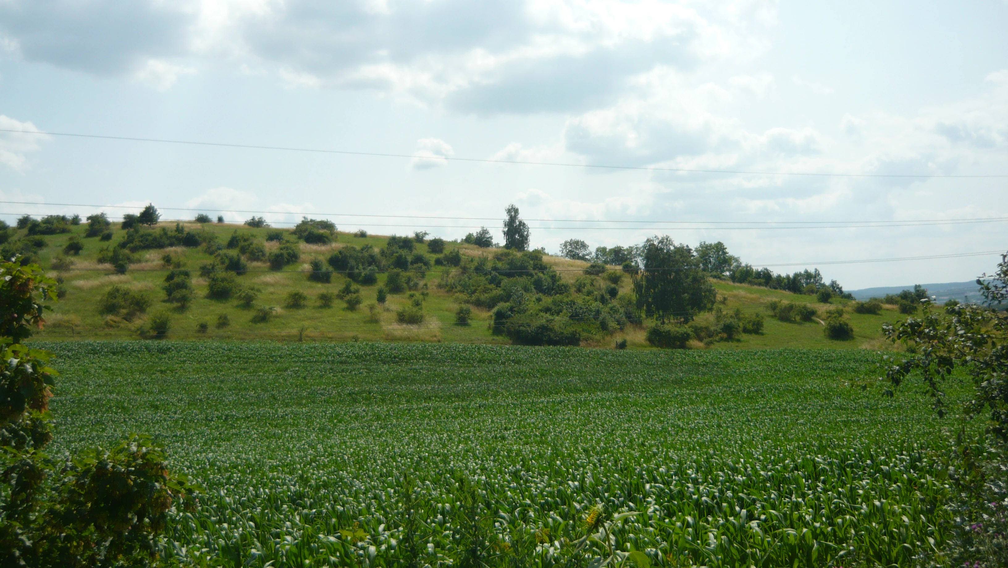
A green field in the foreground leads to a gently sloping hill covered with grass and scattered shrubs under a cloudy sky.
View of the rolling landscape of Střelecký kopec within the Medlánecké kopce area.

Medláněcké kopce wildlife and species highlights

Medláněcké kopce is particularly valued for its thermophilic insect fauna, which is unusually rich for a site so far north in Moravia. The hills mark the northernmost known occurrence of the southern festoon (Zerynthia polyxena) in the Czech Republic, and also host the swallowtail (Papilio machaon), the scarce swallowtail (Iphiclides podalirius), the bagworm moth Ptilocephala muscella, and the praying mantis (Mantis religiosa).

Reptiles recorded here include the sand lizard (Lacerta agilis), the slow worm (Anguis fragilis), and the smooth snake (Coronella austriaca), all of which are typical of warm, dry, open habitats. The bird life reflects the open, scrubby character of the site: the wryneck (Jynx torquilla), barred warbler (Sylvia nisoria), red-backed shrike (Lanius collurio), and golden oriole (Oriolus oriolus) have all been observed on or around the reserve.

The mammalian fauna is less prominent but includes the broader context of the Medlánky airfield colony of European ground squirrels (Spermophilus citellus), and the wider area provides habitat for bats whose roosting and foraging grounds are partly protected in the neighboring Netopýrky reserve.

Medláněcké kopce conservation status and protection priorities

Medláněcké kopce is protected as a přírodní památka, corresponding to IUCN Category IV (habitat/species management area). Its primary conservation objective is the long-term survival of a thermophilic plant and insect assemblage typical of the Central European steppe biome, and in particular the large-flowered pasqueflower (Pulsatilla grandis), which is the headline species of the reserve.

The area also has protective value because it preserves dry, rocky, and loess-based habitats in a region where such environments are increasingly fragmented by urban growth. By maintaining open rock and dry grassland structure, the site supports a group of narrowly distributed plants, including the northernmost Czech population of narrow-leaved sedge (Carex stenophylla), and the northernmost Czech site for the southern festoon butterfly.

From a conservation planning perspective, the reserve is an important node within a small network of urban-edge nature monuments in northern Brno. Its ecological function depends on the persistence of the surrounding low-intensity land use, particularly on the Medlánky airfield grasslands that harbor the European ground squirrel colony, and on the integrity of the nearby Medláněcká skalka and Netopýrky sites.

Medláněcké kopce cultural meaning and human context

The hills have a modest but tangible place in the cultural and administrative geography of Brno. Until the 1960s, both the Medláněcký kopec and Střelecký kopec belonged entirely to the Medlánky cadastral area, and the collective name "Medláněcké kopce" has been retained even after administrative boundaries shifted. Střelecký kopec in particular carries local toponymic significance, echoing the historical presence of shooting-related activity on this northern fringe of the city.

More broadly, the reserve reflects a long tradition of amateur natural history in and around Brno, with botanists and entomologists documenting its unusually thermophilic flora and butterflies for decades before its formal protection in 1988.

Top sights and standout views in Medláněcké kopce

Steppe-like vegetation on metabasite and loess soils in the midst of Brno; large-flowered pasqueflower (Pulsatilla grandis) as the flagship species; the northernmost known Czech sites for narrow-leaved sedge and the southern festoon butterfly; thermophilic butterflies including swallowtail, scarce swallowtail, and praying mantis; a small network of urban-edge dry-grassland reserves including Medláněcká skalka and Netopýrky; and a wider mosaic of dry habitats connected to the ground-squirrel colony on the Medlánky airfield.

Best time to visit Medláněcké kopce

Late spring is the most rewarding season to visit Medláněcké kopce, when the large-flowered pasqueflower is in bloom and butterfly activity on the warm, south-facing slopes is at its highest. Early summer also brings rich displays of thermophilic grassland flowers and active reptiles along the rocky edges. Autumn visits can be quieter but still attractive; visitors should expect the dry, sun-exposed character of the site to be most intense between roughly May and July, when the steppe-like flora is most visible and the insect fauna most active.

Monthly climate preview

Long-term representative point measurements tracking annual temperature and precipitation rhythm

Medlánecké Kopce Climate Normals and Measured Monthly Weather Patterns

Medlánecké kopce exhibits a measured annual rhythm ranging from winter minimum temperatures below freezing to peak summer means above twenty degrees Celsius alongside variable monthly precipitation. Reviewing the complete twelve-month climatology profile provides deeper baseline context for long-term temperature swings and precipitation distribution.
Annual mean9 °C
-3 °C21 °C
Jan-3°
Feb-1°
Mar
Apr
May15°
Jun19°
Jul21°
Aug21°
Sep15°
Oct
Nov
Dec-2°
Warmest month
July

21 °C

Coolest month
January

-2.7 °C

Wettest month
June

2.4 mm/day

Driest month
February

1.1 mm/day

Park location guide

Geography guide, regional context, and park location map for Medláněcké kopce

Medláněcké kopce park geography, regions, and map view in Czechia

Understand where Medláněcké kopce sits in Czechia through a broader geographic reading of the surrounding landscape, nearby location context, and its mapped position within the national park landscape.

How Medláněcké kopce fits into Czechia

Czech Republic is a landlocked Central European country with a population of approximately 10.9 million people. The nation was established as an independent state on January 1, 1993, following the dissolution of Czechoslovakia. Its capital and largest city is Prague, with other major urban centers including Brno, Ostrava, Plzeň, and Liberec.

Wider geography shaping Medláněcké kopce in Czechia

The Czech Republic is a landlocked country in Central Europe. It is bordered by Germany to the west, Austria to the south, Poland to the northeast, and Slovakia to the southeast. The landscape is predominantly hilly, with the territory covering 78,871 square kilometers.

Map view of Medláněcké kopce

Use this park location map to pinpoint Medláněcké kopce in Czechia, understand its exact geographic position, and read its mapped placement within the surrounding landscape more clearly.

Pigeon | © OpenStreetMap contributors

Location context for Medláněcké kopce

Jihomoravský kraj

Visual reference collection showcasing rocky outcrops, steppe grassland, and urban edge terrain.

Medlánecké kopce Photos, Landscape Scenery, and Protected Area Views

Visual records illustrate the rugged terrain and rare steppe vegetation of Medlánecké kopce across changing seasonal conditions. Field imagery helps researchers examine the protected landscape character and rocky outcrops rising above Brno.

A cluster of purple, bell-shaped pasqueflower blossoms with bright yellow centers growing in dry, grassy meadow terrain.

A wide, outdoor landscape shot featuring rolling hills with sparse trees and multiple electrical transmission towers in the distance, set behind a large field of tilled soil and a green grassy foreground.

A low rocky outcrop sits on a dry, grassy hill under a partly cloudy sky, with a forest and distant town visible in the background.

A green field in the foreground leads to a gently sloping hill covered with grass and scattered shrubs under a cloudy sky.

Park atlas

Compare nearby dry grasslands and related regional protected landscapes

Parks Near Medlánecké Kopce And Other Protected Areas In The Surrounding Region

Visitors exploring Medlánecké kopce can continue into other nearby protected areas to examine similar dry grassland habitats and rocky terrain. Comparing adjacent nature reserves provides broader geographic context on regional conservation patterns and urban margin ecosystems.
A soft watercolor painting showing a rolling landscape with hills, scattered trees, and rocky outcrops, rendered in pastel greens and pinks.
Natural monumentBrno
About 0.8 km away#1 closest

North

Medlánecká skalka Natural Monument: Mapped Protected Landscapes and Geography in Brno

A rare urban-adjacent steppe and rocky habitat site

Medlánecká skalka is a protected natural monument located in the Medlánky district of Brno, Czech Republic. Spanning a small but significant rocky slope, this site preserves thermophilous dry-grassland communities and essential habitats for rare flora like the Pulsatilla grandis. Its unique topography and skeletal soil composition make it an important geographic reference point for understanding steppe-like ecosystems in the South Moravian region.

Area
0.003 km²
Established
1999
IUCN
IV
Relief
Upland
Natural monumentJihomoravský kraj
About 3.3 km away#2 closest

Northeast

Soběšické rybníčky Natural Monument: A Detailed Geographic Atlas of the Jihomoravský kraj Forest Ponds

Mapping the protected wetland terrain and amphibian breeding landscapes of central Moravia.

Explore the geographic and conservation profile of Soběšické rybníčky, a protected forest monument in the Czech Republic. The site represents a vital wetland network that maintains stable amphibian populations within a dense, shaded valley setting of the Soběšice Highlands, offering a focused look at small-scale protected landscape management.

Area
0.012 km²
Established
1987
IUCN
IV
Relief
Upland
A minimalist watercolor illustration showing rolling green hills and a few trees against a pale yellow and pink background.
Protected landscapeCzechia
About 3.6 km away#3 closest

Northwest

Přírodní park Baba: A Detailed Geographic Overview of this Czech Protected Landscape

Forested ridges and centuries-old oak woodland topography

Přírodní park Baba is a protected area in Czechia characterized by a continuous six-kilometer ridge rising above the surrounding urban landscape of Brno. This site is defined by its deep-rooted, century-old sessile oak stands and an intricate mosaic of meadows supporting rare orchid species and diverse avian life. Its geological foundation, composed of Paleozoic diorite, supports a resilient ecosystem that serves as a vital natural corridor between Brno and Kuřim.

Area
8.89 km²
Established
1990
Relief
Mountain
Climate
Temperate
Natural monumentJihomoravský kraj
About 3.6 km away#4 closest

West

Skalky u Přehrady: Protected Natural Monument and Mapped Landscape in Jihomoravský kraj

Ecologically significant forest steppe and river gorge terrain

Skalky u Přehrady is a protected natural monument characterized by its rugged diorite cliffs and diverse plant communities. The site serves as a compact example of forest steppe mosaic situated along the Svratka River, offering significant insight into the regional geography and conservation status of rocky slopes within the South Moravian territory.

Area
0.013 km²
Established
1989
IUCN
IV
Relief
Upland
Nature reserveJihomoravský kraj
About 8.1 km away#5 closest

East

Velká Klajdovka Nature Reserve: Steppe and Forest-Steppe Landscape in Jihomoravský Kraj

Ecologically rich protected limestone slopes and terrain near Brno

Velká Klajdovka is a protected natural monument distinguished by its high-value thermophilic vegetation and complex soil structures. Located on the flank of the Hády massif, the reserve offers a unique study of forest-steppe mosaics, rare entomological diversity, and dry oak woodlands that thrive on the boundary of varied geological substrates.

Area
0.09 km²
Established
1988
IUCN
IV
Relief
Upland
A soft watercolor illustration showing a landscape with rolling hills in the background, a cluster of green trees, and a rocky outcrop on the right side.
Natural monumentJihomoravský kraj
About 8.7 km away#6 closest

West

Na Skalách Natural Monument: A Protected Limestone Landscape in the South Moravian Highlands

Geographic study of relict oak woodland and cliffside terrain.

Na Skalách stands as a vital natural monument within Jihomoravský kraj, preserving a steep, south-facing limestone slope along the Svratka River gorge. This compact area offers a window into thermophilic oak forest communities and calcareous rock vegetation, showcasing high botanical value and geological diversity despite its small surface area.

Area
0.01 km²
Established
1991
IUCN
IV
Relief
Upland
Watercolor illustration of a karst landscape featuring hills, a lake, and cave-like rock formations with green vegetation
Protected landscapeSouth Moravian Region
About 13 km away#7 closest

East

Moravian Karst Protected Landscape: Detailed Geographic and Cave System Atlas

Mapped protected boundaries and karst phenomena in the South Moravian Region.

Moravian Karst, designated a Protected Landscape Area, offers a profound look into complex karst geology within the South Moravian Region. This entry within MoriAtlas facilitates a structured discovery of its approximately 92 square kilometers, featuring an intricate network of over 1,100 caves and gorges. Users can explore the mapped extent of this geological treasure, understand its relationship with the surrounding regional geography, and appreciate the unique formations sculpted by underground water systems, including the iconic Macocha Abyss.

Area
92 km²
IUCN
V
Scope
Terrestrial
Water
Minor water
A horizontal watercolor illustration showing rolling green hills and meadows against a soft, pale background, with trees and soft light.
Protected landscapeBrno-venkov District
About 14 km away#8 closest

Southwest

Přírodní park Bobrava Protected Landscape: Geography and Regional Mapping

South Moravian forest and river valley terrain

Přírodní park Bobrava represents an unbroken, forest-heavy landscape situated in the Brno-venkov District. Characterized by its deep river valleys and hilly ridges, this protected territory functions as a crucial natural mosaic of woodlands and meadows, providing a quiet highland retreat that remains distinct from the surrounding urban expansion of the city of Brno.

Area
30.9 km²
Established
1982
Relief
Upland
Climate
Temperate

Common questions about visiting, size, designation, and location context for Medláněcké kopce

Medláněcké kopce FAQs for park facts, access, geography, and protected area context

Find quick answers about Medláněcké kopce, including protected-area facts, park geography, trail and visitor context, and how the park fits into its surrounding country and regional landscape.
MoriAtlas Explorer

Continue Your Protected Areas Search Across the Global Atlas

Deepen your exploration by continuing the structured search for national parks and protected areas worldwide. Utilize the comprehensive filtering capabilities to compare different conservation landscapes and refine your understanding of global park geography. Discover more about the distribution and characteristics of protected natural areas.

Global natural geography