
Mori Atlas logo
Nature reserveMertelstal - Heldrastein

Examining the ecological terrain, cliff formations, and historical boundary geography of this Thuringian protected area.

Mertelstal - Heldrastein Nature Reserve: A Detailed Atlas of Protected Limestone Landscapes and Forests

(Naturschutzgebiet Mertelstal - Heldrastein)

Mertelstal - Heldrastein represents a vital conservation zone within the Wartburgkreis, characterized by its near-natural beech forests and vertical limestone escarpments formed by historical rockfalls. This atlas entry provides a structured look at its unique geomorphology, including the isolated Heldrastein plateau and its significance as a protected habitat within the broader Ringgau region. The area integrates complex natural heritage with layered historical features, ranging from prehistoric hillforts to modern markers of German reunification, all set against the scenic Werra river valley terrain.

beech forestlimestone cliffsNatura 2000FFH sitenature reserveRinggau
Vector-style illustration of a deep mountain valley featuring a winding river, steep rock cliffs on the sides, and a forested foreground under a soft setting sun.

Mertelstal - Heldrastein

Nature reserve

Park overview

Structured park overview, official facts, and landscape profile for Mertelstal-Heldrastein Nature Reserve

Mertelstal-Heldrastein Nature Reserve park facts, protected area profile, and essential visitor context

Review the core facts for Mertelstal-Heldrastein Nature Reserve, including designation, size, terrain, visitor scale, habitats, and operating context in one park-focused overview.

About Mertelstal-Heldrastein Nature Reserve

Mertelstal-Heldrastein is a mid-sized but ecologically rich protected area at the meeting point of Thuringia and Hesse, carved into the edge of the Ringgau plateau above the Werra river. The reserve unites a coherent block of mature broadleaf forest with a striking geological signature: the towering limestone cliffs and rockfall scars of the Hüneburg, Heldrastein, and Dreiherrenstein peaks, where ancient mass movements left sheer rock walls and boulder-strewn slopes now colonized by highly specialized flora.

Ecologically, the area stands out for its concentration of Waldmeister beech forest habitat, with smaller but high-quality patches of slope and ravine mixed forest. Forest inventories have documented extensive yew populations and the presence of the spitzlappige Mehlbeere, a tree endemic to the middle Werra region. The cliffs and screes host an unusually diverse bryophyte and lichen flora of regional bryological importance, including several Red List mosses recorded only sparingly elsewhere in Thuringia.

The reserve's identity is also shaped by its role in European conservation networks. Designated simultaneously as a Thuringian nature reserve and an EU Fauna-Flora-Habitat site under Natura 2000, it is part of a transboundary habitat corridor that reaches into Hesse and links to the Grünes Band Deutschland along the former inner-German border. Its protection aims explicitly at maintaining the beech forest complex, the cliff habitats, and the bat species that depend on the old-growth conditions of these woods.

Quick facts and research context for Mertelstal-Heldrastein Nature Reserve

Mertelstal-Heldrastein is a Thuringian nature reserve of about 252.5 hectares that was officially designated in January 1997, with its FFH-Gebiet status under the EU Habitats Directive confirmed in 2008. It lies in the northwestern Wartburgkreis along the border with Hesse and is administered mostly from the town of Treffurt.

The protected area covers the upper Mertelstal valley and the high ridgeline of the Heldrastein and Hüneburg, with steep limestone cliffs dropping northward toward the Werra river. It sits inside the Naturpark Eichsfeld-Hainich-Werratal and connects ecologically with the Hessian Dreiherrenstein-Eschenberg-Kreutzerberg reserve across the state border, forming a continuous habitat corridor.

Protection and recognition

Explore official designation history and terrestrial conservation records

Mertelstal - Heldrastein Protection Status and International Recognition

Mertelstal - Heldrastein maintains documented terrestrial protection status established in 2008 alongside recorded Natura 2000 recognition sources. Official designation records outline the historical framework and management scope governing this protected natural area.

International recognition

Protection details

Protection scope
Terrestrial
Designated year
2008
Transboundary protection
No
WDPA ID
14485
Park context

Deeper park guide and search-rich context for Mertelstal-Heldrastein Nature Reserve

Mertelstal-Heldrastein Nature Reserve history, landscape, wildlife, and travel context

Explore Mertelstal-Heldrastein Nature Reserve through its history, landscape character, ecosystems, wildlife, conservation priorities, cultural context, and seasonal travel timing in a structured park guide built for atlas discovery and search intent.

Why Mertelstal-Heldrastein Nature Reserve stands out

The reserve is best known for its extensive, near-natural beech forests clinging to steep Triassic limestone cliffs, including rare orchid-rich woodland and the unusual presence of the spitzlappige Mehlbeere, a regional endemic limited to the middle Werra area. Its bryophyte-rich rock habitats and bat populations, particularly the lesser horseshoe bat and Bechstein's bat, are signature conservation features. Equally distinctive is the symbolic Turm der Einheit on the Heldrastein summit, a 30-meter former military mast converted into a viewing tower after reunification that today offers sweeping vistas across the Werra valley, Eichsfeld, Hoher Meißner, Thuringian Forest, and Rhön.
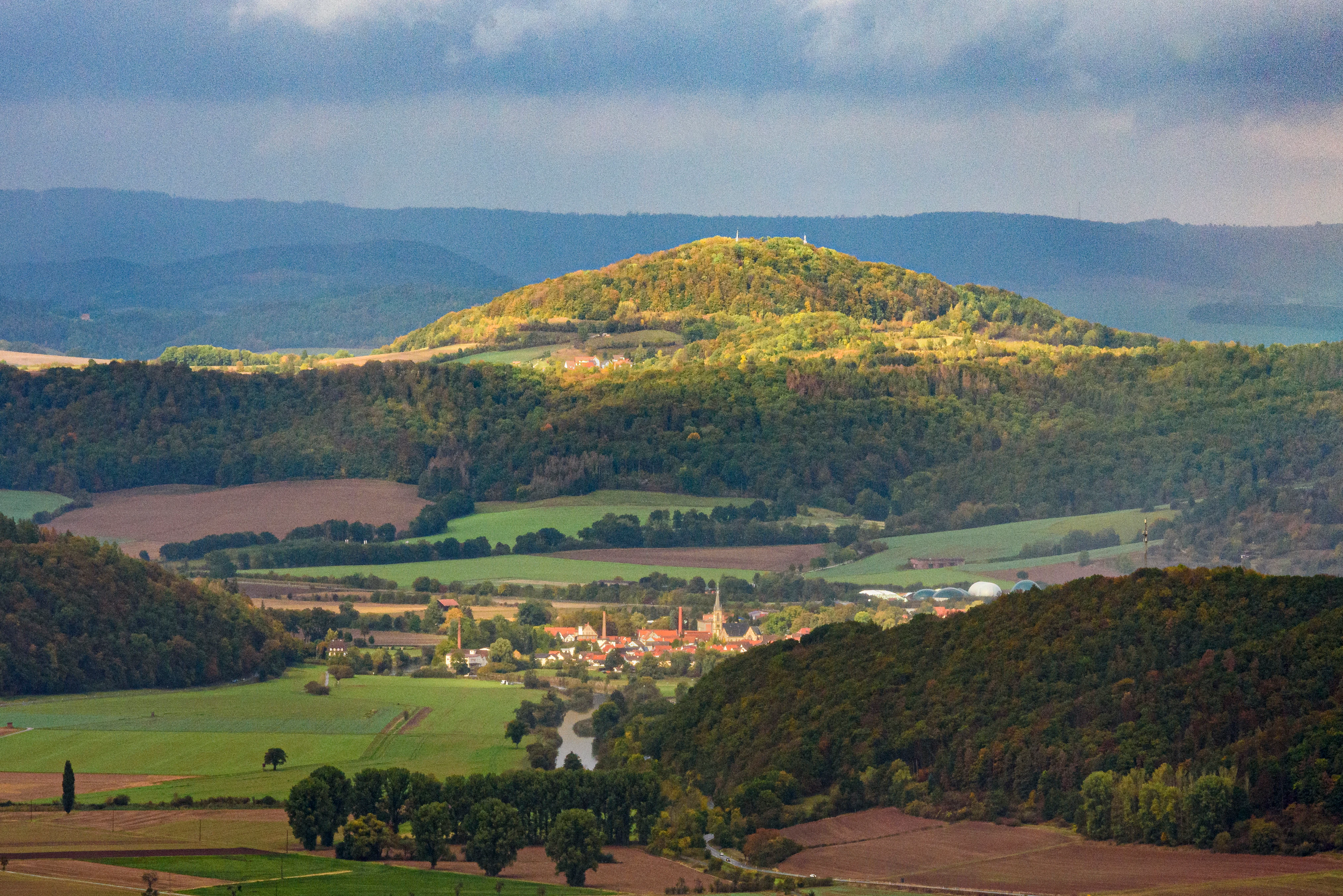
A wide landscape view of rolling hills, forested slopes, and agricultural valley land under a cloudy sky.
A scenic view looking toward Hulfensberg from the Heldrastein, overlooking the Werra valley and the town of Wanfried.

Mertelstal-Heldrastein Nature Reserve history and protected-area timeline

The first formal safeguards around the Mertelstal were put in place in May 1961, growing out of provisional protection measures between 1957 and 1961. By the mid-1990s, the area was unified with the surrounding Heldrastein and Hüneburg forest under the name Mertelstal-Heldrastein, and on 7 January 1997 the Thuringian administrative office in Weimar officially designated 252.5 hectares as a nature reserve aimed at preserving the near-natural beech forests and their associated rare species.

A second chapter began in September 2000, when the Thuringian environment ministry proposed the reserve for inclusion in the European Natura 2000 network under the EU Habitats Directive. Following federal reporting to the European Commission, the site was added to the EU list of sites of community importance in December 2004, and the formal Natura 2000 conservation objectives ordinance was issued in May 2008, specifically targeting the beech woodlands and their bat fauna together with the rockfall cliffs. In 2018, a strip of the reserve along the former border was integrated into the Grünes Band Deutschland National Natural Monument.

Long before any modern protection, the area was home to an Iron Age hillfort on the Hüneburg plateau, occupied from roughly the 6th to 4th centuries BC and reused in the late Middle Ages. During the Thirty Years' War, villagers from the Werra valley took refuge in the Heldrastein's caves, including a cavity later associated with an 18th-century robber named Henning. The 19th century saw the Heldrastein become a popular excursion destination under the older name Hellerstein, crowned first by a small stone lookout and then by a tower named after Grand Duke Karl Alexander of Saxe-Weimar-Eisenach. During the German division, the summit was sealed inside the inner-German border exclusion zone and used by the Stasi for radar and surveillance; after 1989 a citizens' initiative transformed the remaining 30-meter lattice mast into the Turm der Einheit, inaugurated in May 1997.

Mertelstal-Heldrastein Nature Reserve landscape and geographic character

The reserve is set on the northwestern edge of the Ringgau, a tabular Muschelkalk plateau that was once separated from the main limestone escarpment of the Thuringian Basin by the Werra river, leaving the Heldrastein as an isolated Zeugenberg roughly bisected by a tectonic graben. The long Netra-Ifta depression further divides the Ringgau, placing the Heldrastein on the northern side where the cliffs fall steeply, sometimes vertically, toward the Werra floodplain.

Three peaks frame the protected area: the Hüneburg at 495.4 meters, the Heldrastein at 503.8 meters, and the Dreiherrenstein at 488.5 meters, all crowned by exposed rock faces and scree aprons produced by historical landslides. These Abrisswände form dramatic near-vertical limestone walls on the north and east, while gentler forested slopes run along the plateau and toward the Mertelstal to the south. The terrain sits between roughly 270 meters in the valley bottom and just over 500 meters on the summits, giving the reserve a striking vertical relief over a relatively compact footprint.
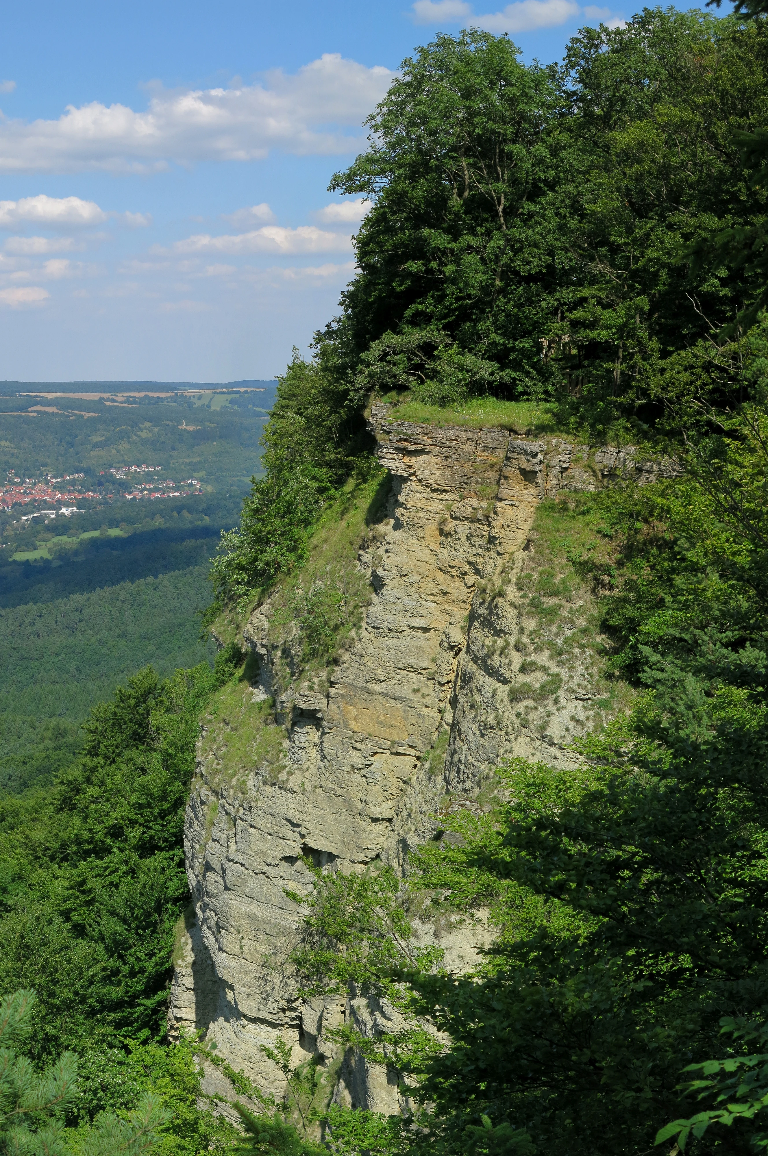
A steep, vertical limestone rock face partially covered in green trees, overlooking a distant valley under a blue sky.
Limestone rock face at the Heldrastein summit, Mertelstal-Heldrastein nature reserve.

Mertelstal-Heldrastein Nature Reserve ecosystems, habitats, and plant life

Ecologically, Mertelstal-Heldrastein is dominated by mature, near-natural deciduous forest that has developed largely from historical coppice-with-standards management. Surveys by ThüringenForst classified the woodland primarily as Waldmeister beech forest (habitat type 9130), with smaller, valuable shares of priority slope and ravine mixed forest (9180*) and Hainsimsen beech forest (9110), giving the reserve a layered composition of pure beech stands and mixed broadleaf forest.

Beyond the forest itself, the reserve encompasses three specially surveyed rocky habitat types: limestone scree slopes (8160*), calcareous rock with crevice vegetation (8210), and non-tourist caves (8310). The screes below the cliffs have accumulated characteristic plants such as Kalk-Blaugras, Ruprechtsfarn, and Ruprechtskraut, while the shaded limestone outcrops support a specialist community of small ferns, mosses, and lichens, anchored by the Braunstieliger Streifenfarn. Around 200 moss species and more than 40 moss associations have been documented, and approximately 80 lichen species are recorded in the area.

The woodland flora includes a notable suite of rare and protected orchids, such as the white and red Cephalanthera, spotted Dactylorhiza, multiple Epipactis species, and the bird's-nest orchid. The presence of numerous yews and the regional endemic spitzlappige Mehlbeere, a tree otherwise restricted to the middle Werra region, give the forest an unusually distinctive botanical profile.
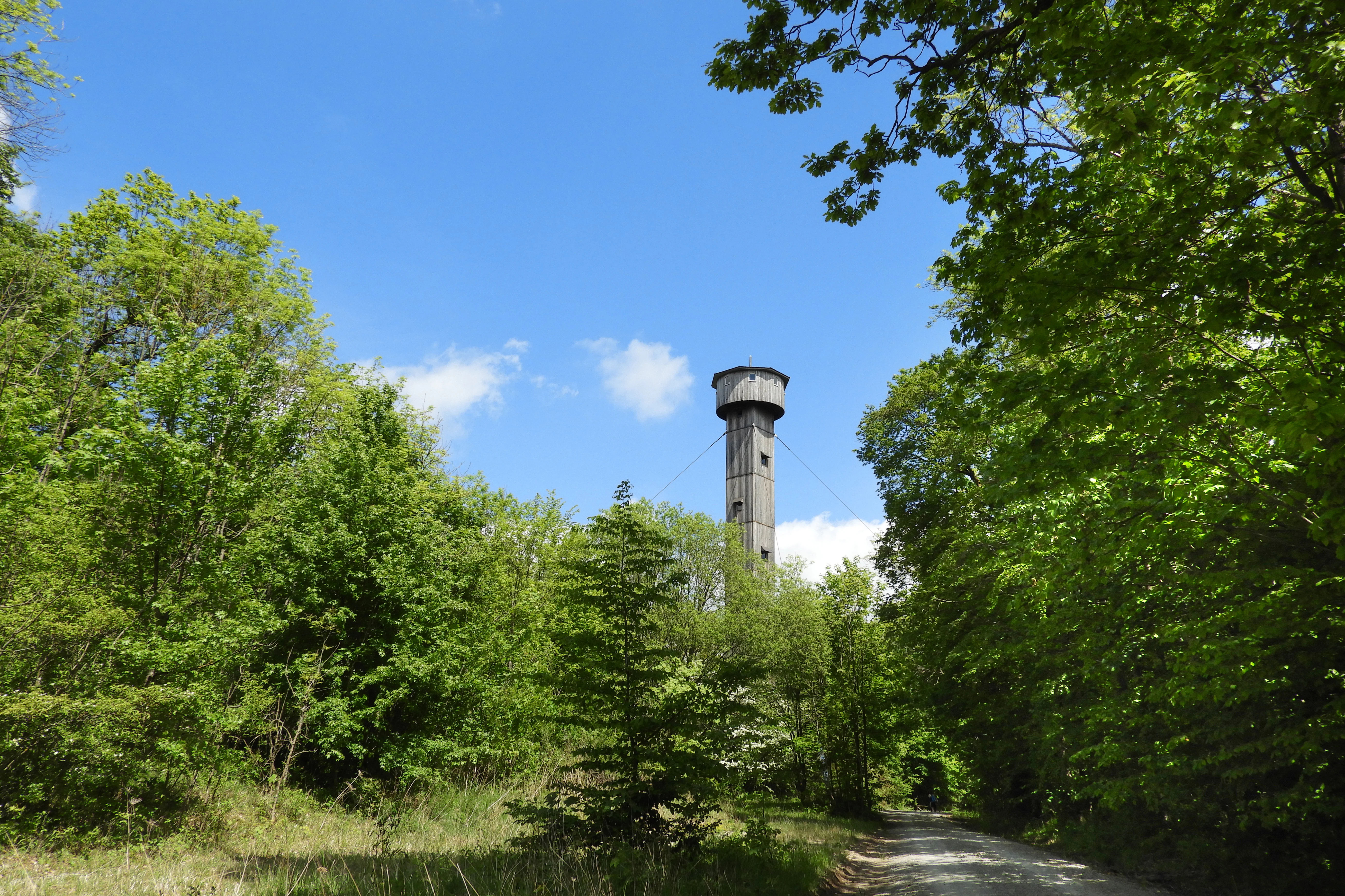
A tall, slender observation tower surrounded by dense green deciduous trees under a clear blue sky in Thuringia.
The Tower of Unity stands atop the Heldrastein plateau, surrounded by the lush beech forest of the Mertelstal - Heldrastein nature reserve.

Mertelstal-Heldrastein Nature Reserve wildlife and species highlights

The protected area's most important animal residents are its bats. The lesser horseshoe bat, one of Europe's smallest horseshoe species, and Bechstein's bat, a secretive woodland bat, both occur here and were central to the site's selection as a Fauna-Flora-Habitat area. Thuringia holds Germany's largest lesser horseshoe population, and the Bechstein's bat has a notable center of distribution in Germany, placing strong national responsibility on these forests and their old trees for continued conservation.

The site also supports other bat species of conservation concern, including the Natterer's bat and brown long-eared bat, all strictly protected under German nature law. Among birds, eagle owls, peregrine falcons, red kites, and black and grey-headed woodpeckers use the landscape as breeding or feeding territory, all species listed under Annex I of the EU Birds Directive. Invertebrate diversity is unusually rich, with over fifty land snail species recorded in the slope-debris forests and a lepidoptera fauna that includes the Veilchen-Perlmuttfalter, Perlbinde, Kommafalter, more than seventy noctuid moths, over eighty geometer moths, and around forty bombycid and hawk moths documented just from the Heldrastein.
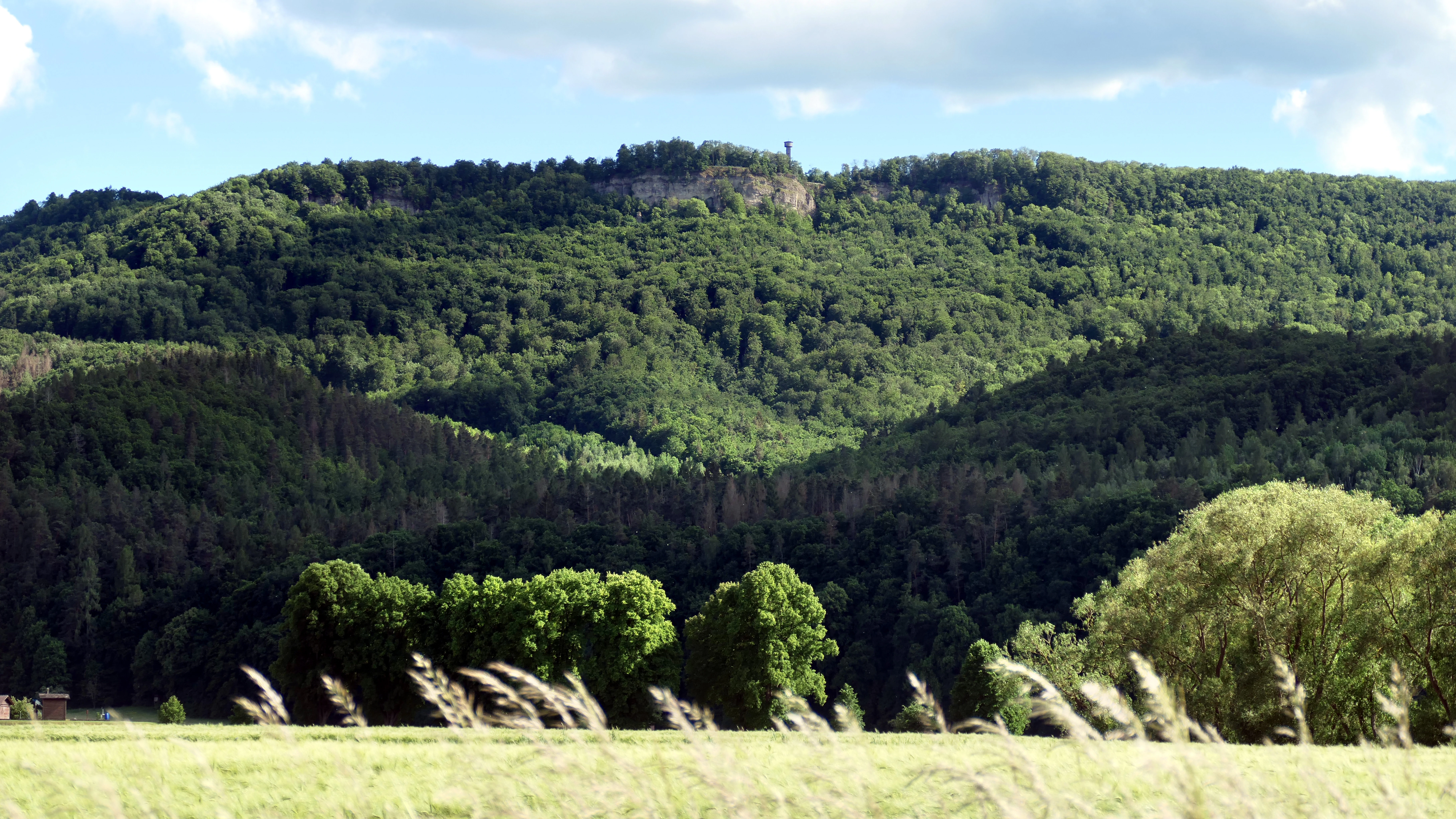
A wide landscape view of a green forested mountain with steep limestone cliffs near the summit, where a small observation tower stands. A grassy meadow with wind-swept plants occupies the foreground.
The Heldrastein mountain, featuring the Unity Tower, viewed from the valley below.

Mertelstal-Heldrastein Nature Reserve conservation status and protection priorities

Mertelstal-Heldrastein serves as both a national nature reserve and a European site of community importance, giving it a dual conservation mandate. The primary purpose is the preservation of near-natural beech forest habitats and the ancient cliff and scree environments of the Ringgau edge, including the rare orchid-rich flora, the regionally endemic spitzlappige Mehlbeere, and the unusually diverse bryophyte community of over 200 moss species.

The site's bat populations, especially the lesser horseshoe bat and Bechstein's bat, are explicitly singled out in EU conservation objectives because Germany bears substantial responsibility for their survival. Forest management is oriented toward maintaining old-growth conditions: threats include pesticide use, loss of roosts and old trees, and forestry practices that remove veteran timber and cavity-bearing trees. As part of the Natura 2000 network and partially inside the Grünes Band Deutschland National Natural Monument, the reserve contributes to a transboundary corridor linking Thuringian and Hessian protected areas and the broader former-border habitat chain.

Mertelstal-Heldrastein Nature Reserve cultural meaning and human context

The landscape carries a dense cultural memory alongside its ecological role. The Hüneburg, east of the Heldrastein summit, was an Iron Age hillfort with a defensive ditch and rampart accessed only from the plateau, occupied from the 6th to 4th centuries BC and reused in the late medieval period; it is now a protected archaeological monument.

Centuries later, the cliff caves provided refuge during the Thirty Years' War, and one chamber, the Henningshöhle, became associated with an 18th-century robber who raided as far as Eschwege and Mühlhausen. The Heldrastein, originally called Hellerstein for its bright limestone faces, became a 19th-century excursion destination crowned first by a small stone lookout around 1840 and then by a tower named after Grand Duke Karl Alexander of Saxe-Weimar-Eisenach. Its most recent chapter is the Turm der Einheit, a converted GDR surveillance mast inaugurated in May 1997, now serving as a regional viewing point and a symbol of reunification, while the nearby Dreiherrenstein marks an old tri-border point where, down through the centuries, ruling territories repeatedly changed hands.
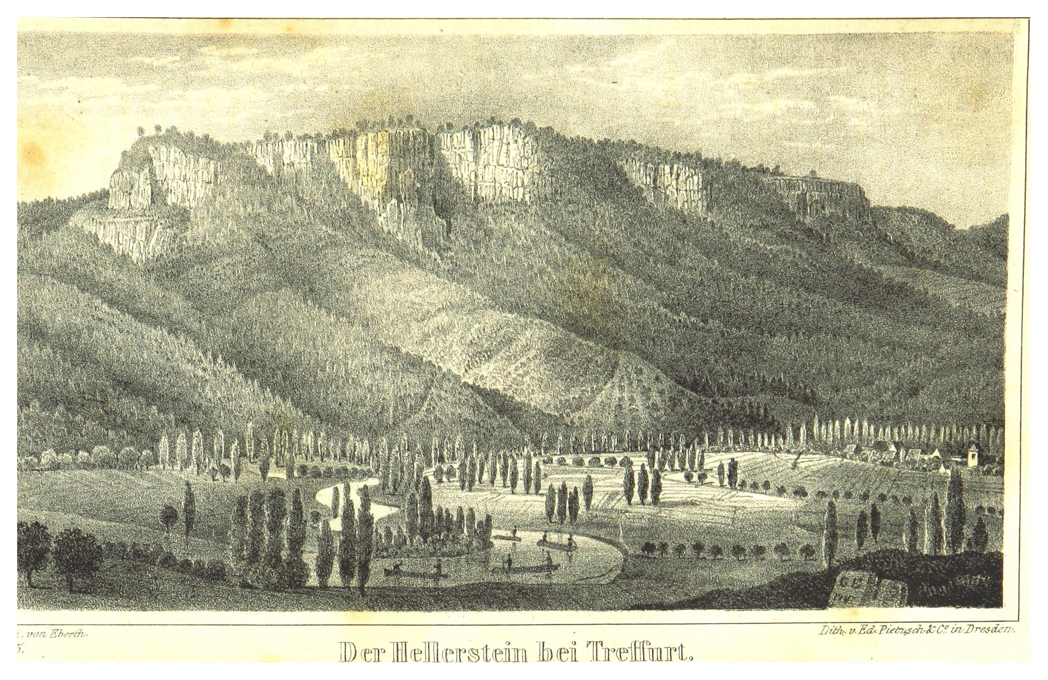
A black and white historic lithograph showing the steep rocky cliffs of Heldrastein rising above a forested slope, with a river and valley landscape in the foreground.
A historic lithograph depicting the Heldrastein limestone cliffs near Treffurt.

Top sights and standout views in Mertelstal-Heldrastein Nature Reserve

Three features make Mertelstal-Heldrastein stand out among central German nature reserves. It combines some of Thuringia's oldest near-natural beech forests with rare orchid and bryophyte communities that have developed on calcareous rockfall cliffs, including the locally endemic spitzlappige Mehlbeere and a moss flora of regional bryological importance. Its bat populations, particularly the lesser horseshoe bat and Bechstein's bat, anchor a strong conservation profile within the European Natura 2000 network.

Equally distinctive is the layering of political and cultural history: an Iron Age hillfort on the Hüneburg, Thirty Years' War cave refuges, nineteenth-century tourism on the Hellerstein, and a GDR surveillance site transformed after 1989 into a public symbol of reunification. Long-distance trails such as the Barbarossaweg, the Wanderweg der Deutschen Einheit, the Ars Natura sculpture path, and the Geo-Naturpark Frau-Holle-Land premium trail P6 all run through the reserve, linking its ecological and historical identity.
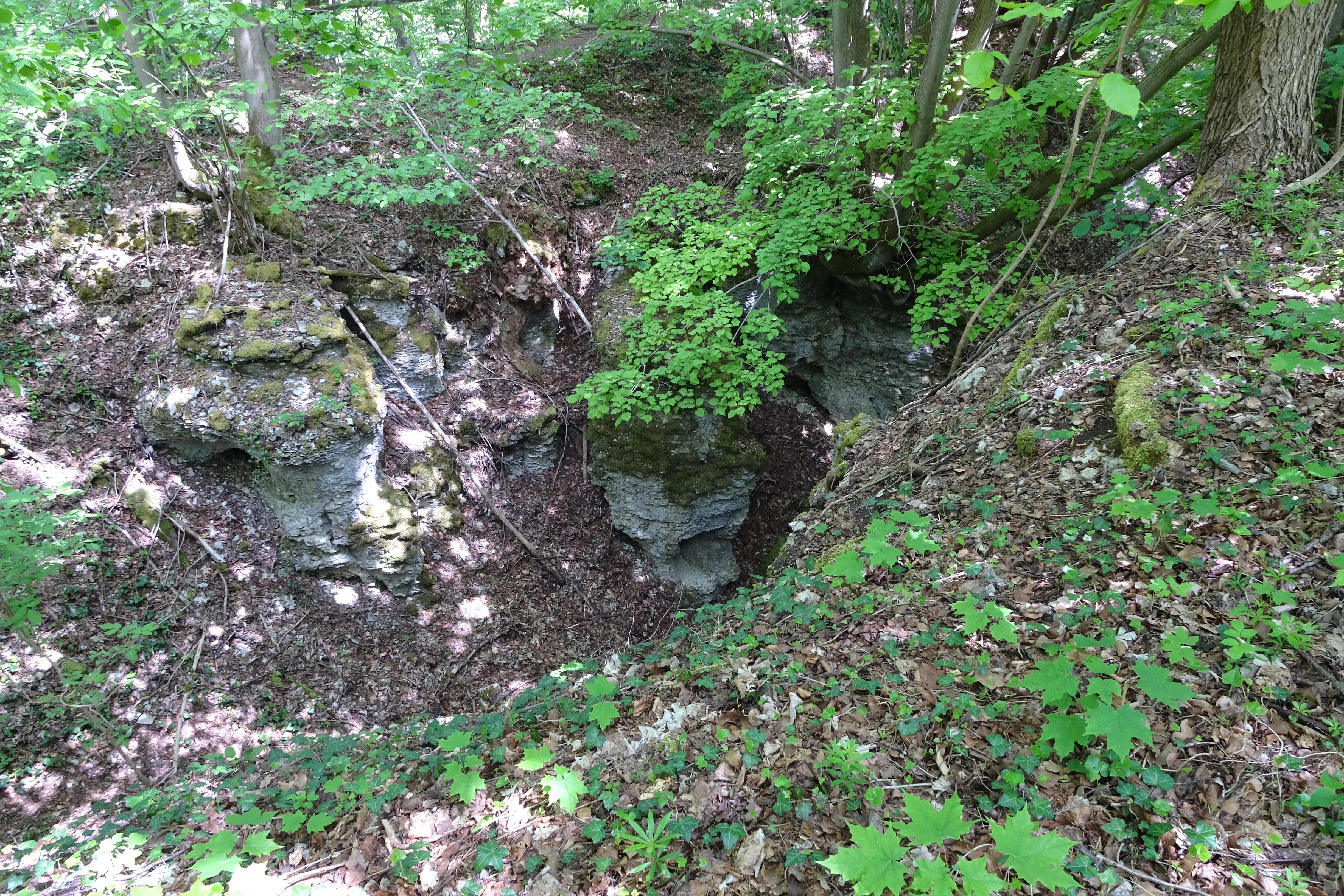

A high-angle view of a deep, narrow geological rift or crevice in a forested limestone area, showing exposed rocky cliffs partially covered by moss, surrounded by deciduous trees and leaf litter.
A geological rift, or Abrisskluft, located within the forest at Heldrastein.
Monthly climate preview

Long-term representative temperature and precipitation averages recorded at Wartburgkreis

Mertelstal - Heldrastein Climate Normals and Weather by Month

Mertelstal - Heldrastein exhibits a measured annual temperature and precipitation rhythm across twelve recorded climatological months from NASA POWER data. Examining the complete monthly climate profile reveals detailed thermal fluctuations and precipitation patterns for this protected terrain.
Annual mean8 °C
-1 °C18 °C
Jan-1°
Feb
Mar
Apr
May12°
Jun16°
Jul18°
Aug18°
Sep14°
Oct
Nov
Dec
Warmest month
July

18.3 °C

Coolest month
January

-1.1 °C

Wettest month
July

2.6 mm/day

Driest month
April

1.4 mm/day

Park location guide

Geography guide, regional context, and park location map for Mertelstal-Heldrastein Nature Reserve

Mertelstal-Heldrastein Nature Reserve park geography, regions, and map view in Germany

Understand where Mertelstal-Heldrastein Nature Reserve sits in Germany through a broader geographic reading of the surrounding landscape, nearby location context, and its mapped position within the national park landscape.

How Mertelstal-Heldrastein Nature Reserve fits into Germany

Germany is a federal republic in Western and Central Europe with a population of over 83 million across sixteen constituent states. It is Europe's largest economy by nominal GDP and a major global exporter and importer. The capital is Berlin, and the country borders Denmark, Poland, Czech Republic, Austria, Switzerland, France, Luxembourg, Belgium, and the Netherlands.

Wider geography shaping Mertelstal-Heldrastein Nature Reserve in Germany

Germany is located in Western and Central Europe, spanning 357,022 km². It borders Denmark to the north, Poland and the Czech Republic to the east, Austria and Switzerland to the south, and France, Luxembourg, Belgium, and the Netherlands to the west. The country has coastlines on the Baltic Sea and North Sea to the north, with the Alps located in the southern region.

Map view of Mertelstal-Heldrastein Nature Reserve

Use this park location map to pinpoint Mertelstal-Heldrastein Nature Reserve in Germany, understand its exact geographic position, and read its mapped placement within the surrounding landscape more clearly.

Pigeon | © OpenStreetMap contributors

Location context for Mertelstal-Heldrastein Nature Reserve

ThuringiaWartburgkreis
Recorded earthquake history

Examine the Historical Seismic Records Associated with Mertelstal - Heldrastein

Access a curated catalogue of historical earthquake data linked to the Mertelstal - Heldrastein nature reserve by proximity. This MoriAtlas resource helps visitors and researchers examine recorded seismic activity patterns near the Heldrastein plateau and the surrounding limestone terrain of the Wartburgkreis.

Mertelstal - Heldrastein Earthquake Records

Catalogued events

4 events

Strongest magnitude

Magnitude 3.6

Most recent event

Oct 25, 2006

This history includes earthquakes recorded inside the park or within 50 km of its borders

Visual reference for limestone cliffs, beech forests, and protected terrain

Mertelstal - Heldrastein Landscape and Scenery Photos

Visual records document the near-natural beech forests and dramatic limestone cliffs defining the Mertelstal - Heldrastein protected area. Examining field photography reveals the rugged terrain, steep rock faces, and distinct ecological character of the reserve.

A wide landscape view of rolling hills, forested slopes, and agricultural valley land under a cloudy sky.

A dense forest of tall, slender beech trees with vibrant green spring foliage, forming a closed canopy over the forest floor.

A steep, vertical limestone rock face partially covered in green trees, overlooking a distant valley under a blue sky.

A tall, slender observation tower surrounded by dense green deciduous trees under a clear blue sky in Thuringia.

A wide landscape view of a green forested mountain with steep limestone cliffs near the summit, where a small observation tower stands. A grassy meadow with wind-swept plants occupies the foreground.

A wide, high-angle landscape shot taken from a cliffside; in the foreground are bright green bushes and yellow wildflowers, while the background reveals a sweeping valley with forested hills, agricultural fields, and two small towns under a blue, cloudy sky.

A black and white historic lithograph showing the steep rocky cliffs of Heldrastein rising above a forested slope, with a river and valley landscape in the foreground.

A high-angle view of a deep, narrow geological rift or crevice in a forested limestone area, showing exposed rocky cliffs partially covered by moss, surrounded by deciduous trees and leaf litter.

Park atlas

Compare adjacent limestone landscapes and regional conservation areas in the Werra river valley.

Explore Other Parks and Protected Areas Near Mertelstal - Heldrastein

Continue your geographic exploration by browsing other protected areas situated near Mertelstal - Heldrastein and the surrounding Thuringian uplands. Comparing these neighboring forest reserves and limestone escarpments reveals the wider ecological patterns connecting regional conservation landscapes.
Watercolor illustration showing a wide landscape with green rolling hills in the background, a line of trees in the midground, and a pinkish meadow with grasses in the foreground
Nature reserveHesse
1.4 km away#1 closest

Northeast

Frankenloch bei Heldra Nature Reserve: Mapped Protected Landscapes in Hesse, Germany

A rare, near-natural Werra river oxbow and wetland floodplain sanctuary.

Discover the geographic layout of Frankenloch bei Heldra, a protected nature reserve located along the River Werra. This site offers insight into floodplain dynamics, reed-bed ecology, and the restoration of natural river channels within the Werra-Meissner-Kreis district of Hesse, Germany.

Area
0.089 km²
Established
1995
Relief
Lowland
Climate
Temperate
Watercolor painting of a green landscape featuring rolling hills and sparse trees.
Nature reserveWerra-Meißner-Kreis
About 1.6 km away#2 closest

Northeast

Dreiherrenstein-Eschenberg-Kreutzerberg Nature Reserve and Border Landscape Geography

Protected calcareous forests and limestone ridges in Werra-Meißner-Kreis

Spanning 206 hectares of the Ringgau escarpment, this reserve features ancient beech forests, steep limestone cliffs, and rare steppe-heath grasslands. It sits at a cultural and ecological intersection, preserving Cold War-era boundary markers alongside post-glacial biological relicts within the broader Hessian protected-area network.

Area
2.063 km²
Established
1998
IUCN
IV
Relief
Mountain
Nature reserveThuringia
1.7 km away#3 closest

Northeast

Werra bis Treffurt mit Zuflüssen: Protected River and Floodplain Network in Thuringia

Mapping an extensive 191 kilometer Natura 2000 river corridor.

The Werra bis Treffurt mit Zuflüssen protected area serves as a vital ecological corridor in Thuringia. This site encompasses a complex mosaic of fast-flowing highland brooks, expansive floodplain meadows, inland salt sites, and rare dissolution lakes. Its geography bridges high-altitude source regions with lower river valleys, creating a distinctive landscape transect that supports essential freshwater habitats and rare aquatic species across the state.

Area
22.6 km²
Established
2008
IUCN
IV
Relief
Mixed relief
Nature reserveWartburgkreis
About 2.2 km away#4 closest

Northeast

Werraaue Treffurt Nature Reserve: Geographic Overview and Protected Floodplain Map

Wartburgkreis wetland refuge and Green Belt stepping stone

Werraaue Treffurt comprises a complex riverine landscape where sediment-rich floodplain soils and restored gravel-pit lakes create a diverse sanctuary. Located near the Thuringia-Hessia state border, this nature reserve integrates into the broader Green Belt, offering significant habitat continuity for species dependent on transition zones. Its position in the Werra valley floor highlights the intersection of hydrological change, historical land-use exclusion, and modern ecological protection in Germany.

Area
0.685 km²
Established
1995
IUCN
IV
Relief
Lowland
A horizontal watercolor painting depicting a soft-toned, layered landscape of rolling hills and forests in shades of green and pale yellow.
Nature reserveThuringia
2.8 km away#5 closest

Northeast

Adolfsburg, Bornberg, Sülzenberg: A Protected Muschelkalk Landscape in Thuringia

Geographic map and protected-area atlas context

This nature reserve stands as a prominent geological feature in the Werrabergland region, where steep Muschelkalk hills and plateaus meet the Werra valley. The site protects a rare assembly of habitats including juniper heathland, scree slopes, and old-growth orchards, offering a dense case study for regional botanical diversity and limestone-terrain mapping in central Germany.

A watercolor painting depicting a soft, green meadow landscape with gentle rolling hills in the background and scattered trees.
Nature reserveGermany
About 3.3 km away#6 closest

North

Feuchtwiesen bei Lüderbach Nature Reserve: Regional Geography and Protected Landscape Atlas

A diverse wetland and grassland reserve in northern Hesse, Germany

Spanning 40 hectares in the Werra-Meißner-Kreis district, Feuchtwiesen bei Lüderbach protects a complex mosaic of reedbeds, eutrophic ponds, and floodplain forests. This nature reserve serves as an important ecological link in the Netra-Ifta valley, bridging valley-bottom wetlands with the limestone-rich slopes of the Weinberg hill to create a distinct and valuable natural terrain in the German landscape.

Area
0.41 km²
Established
1995
Relief
Upland
Climate
Temperate
Watercolor illustration showing a wide landscape with green trees, rolling hills, and distant mountains under a pale sky.
Nature reserveHessen
About 4.1 km away#7 closest

North

Graburg Nature Reserve and Protected Shell-Limestone Massif in Northern Hessen

Mapped protected areas and botanical landscape geography

Graburg is a compact shell-limestone plateau located in the Ringgau range of northern Hessen. This nature reserve is characterized by its high conservation value, featuring ancient calcareous beech forests, dramatic rock faces, and extensive historic landslide zones that support one of the most botanically diverse habitats in central Germany.

Area
3.41 km²
Established
1965
IUCN
IV
Nature reserveThuringia
4.8 km away#8 closest

Northeast

Werrahänge von Frankenroda bis Falken: A Deep Dive into Thuringian Protected Landscapes

Mapping limestone river canyons and unique forest habitats in Wartburgkreis.

This protected area captures a distinct geomorphological intersection of river-cut canyons and plateau ridges in Thuringia. The site preserves an intense mosaic of juniper heath, dry grasslands, and ancient beech forests, functioning as a vital link for species conservation. Examine the mapped boundaries, karst features, and the sculptural topography formed by the Werra river as it winds through the Muschelkalk rim of the Thuringian Basin.

Area
5.69 km²
Established
1999
IUCN
IV
Relief
Upland

Common questions about visiting, size, designation, and location context for Mertelstal-Heldrastein Nature Reserve

Mertelstal-Heldrastein Nature Reserve FAQs for park facts, access, geography, and protected area context

Find quick answers about Mertelstal-Heldrastein Nature Reserve, including protected-area facts, park geography, trail and visitor context, and how the park fits into its surrounding country and regional landscape.
MoriAtlas Explorer

Continue Your Protected Areas Search Across the Global Atlas

Deepen your exploration by continuing the structured search for national parks and protected areas worldwide. Utilize the comprehensive filtering capabilities to compare different conservation landscapes and refine your understanding of global park geography. Discover more about the distribution and characteristics of protected natural areas.

Global natural geography