

Mori Atlas logo
Nature reserveMerzhäuser Teiche

Explore the mapped boundaries, alder swamp landscapes, and diverse aquatic habitats of this compact Hessen reserve.

Merzhäuser Teiche Nature Reserve: A Detailed Geographic Atlas of this Hessen Wetland Protected Area

(Naturschutzgebiet „Merzhäuser Teiche“)

Merzhäuser Teiche represents a significant ecological refuge within the Burgwald region of Hessen, Germany. This protected landscape centers on a chain of three ponds fed by the Kimmelbach, surrounded by a complex mosaic of alder swamp forests, wet meadows, and traditional sheep-grazed grasslands. The site functions as a vital wetland node for migratory birds, amphibians, and diverse insect populations, offering a dense, structured overview of regional German biodiversity.

nature reservewetlandpondswaterbird habitatbird sanctuaryNatura 2000

Merzhäuser Teiche

Nature reserve

Park overview

Structured park overview, official facts, and landscape profile for Merzhäuser Teiche

Merzhäuser Teiche park facts, protected area profile, and essential visitor context

Review the core facts for Merzhäuser Teiche, including designation, size, terrain, visitor scale, habitats, and operating context in one park-focused overview.

About Merzhäuser Teiche

Merzhäuser Teiche is a compact nature reserve that captures a surprisingly rich slice of central German wetland ecology within a footprint of about 20 hectares. Positioned immediately east of the K 19 district road between the villages of Rosenthal and Bracht, the reserve occupies the floodplain of the Kimmelbach, a stream flowing out of the Burgwald before joining the Bentreff roughly 1.5 kilometres downstream.

The protected area is built around three small impounded ponds, each lined by reed beds, tall-herb vegetation, shrubs, and alders. Between them lies an extensive stretch of seasonally flooded alder carr, with hedgerows and bushes continuing the wooded character along the field paths and roads at the northern end of the reserve. Outside the wooded fringes, traditionally managed wet meadows dominate the floodplain, while the steeper slopes carry seminatural grassland with a leaner, dry-land character. Sheep grazing in traditional pasture style keeps these drier openings open and botanically diverse.

Ecologically, Merzhäuser Teiche stands out as a refuge where forest, stream, pond, meadow, and seminatural grassland meet within a very short distance. The reserve is formally part of the EU Bird Protection Area "Burgwald" and sits within the Natura 2000 ecological network, giving it recognition well beyond its modest size. It is designated under the IUCN framework as a habitat and species management area.

For visitors and naturalists, the reserve offers a quiet walking landscape defined by still water, alder woodland, and grazing meadows, with viewpoints along the surrounding lanes that allow observation without disturbing the breeding birds. Despite pressures from declining amphibian populations since the 1980s and the loss of the northern crested newt, the site continues to function as an important local stronghold for wetland biodiversity.

Quick facts and research context for Merzhäuser Teiche

Merzhäuser Teiche is a nature reserve of roughly 20 hectares in the Marburg-Biedenkopf and Waldeck-Frankenberg districts of Hesse, Germany. It was designated as a Naturschutzgebiet in 1990 and re-regulated under a fresh protection ordinance in 2001. The reserve sits at the western edge of the Burgwald forest and lies within the EU Birds Directive site "Burgwald," itself part of the Natura 2000 network.

The site protects three dammed ponds along the Kimmelbach, fringed by alder swamp forest, reed and tall-herb vegetation, hedgerows, wet meadows, and nutrient-poor seminatural grassland kept open through sheep grazing. It is managed as a habitat and species management area under IUCN Category IV. The reserve is recognised for its waterbird breeding populations, numerous migratory species, and a notable dragonfly and butterfly fauna.

Protection and recognition

Documented terrestrial protection records and international designation data

Merzhäuser Teiche Protection Status and Official Designation History

Merzhäuser Teiche holds a documented terrestrial protection status established in two thousand one within global conservation databases. Official records outline the formal designation history and management scope associated with this protected area.

Protection details

Protection scope
Terrestrial
Designated year
2001
Transboundary protection
No
WDPA ID
164613
Park context

Deeper park guide and search-rich context for Merzhäuser Teiche

Merzhäuser Teiche history, landscape, wildlife, and travel context

Explore Merzhäuser Teiche through its history, landscape character, ecosystems, wildlife, conservation priorities, cultural context, and seasonal travel timing in a structured park guide built for atlas discovery and search intent.

Why Merzhäuser Teiche stands out

Merzhäuser Teiche is best known for being a small but extraordinarily bird-rich wetland reserve, with more than 120 bird species observed and a confirmed breeding list of over 50 species. The ponds are a regular breeding site for little grebes and coots and serve as a staging area for migratory ducks, waders, and raptors including osprey. Beyond birds, the reserve is recognised for its compact mosaic of alder swamp forest, wet meadows, and seminatural grassland that supports a diverse amphibian community, numerous dragonflies, and around 80 recorded butterfly species. Its integration into the broader Burgwald forest landscape gives the small site an outsized ecological significance for waterbird and wetland habitat in central Hesse.
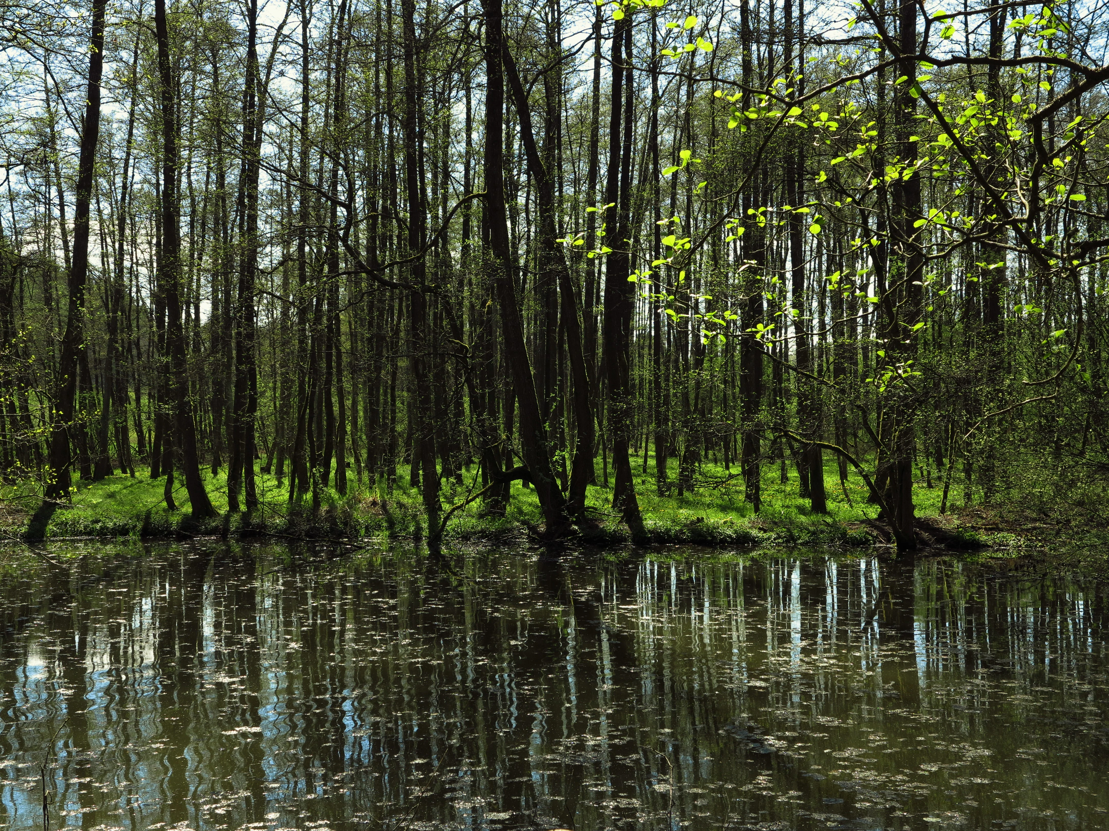
Merzhäuser Teiche Nature Reserve
Pond and alder swamp forest in the Merzhäuser Teiche nature reserve southeast of Rosenthal.

Merzhäuser Teiche history and protected-area timeline

Merzhäuser Teiche was first formally designated as a nature reserve (Naturschutzgebiet) in 1990, establishing legal protection for the ponds, the alder swamp forest, and the surrounding meadows in the Kimmelbach valley. The original protection was updated and consolidated in 2001, when the responsible regional authority issued a new ordinance refining the boundaries and management framework for the reserve.

The site was subsequently incorporated into the broader European ecological network when the surrounding Burgwald landscape was recognised as an EU Birds Directive site, placing Merzhäuser Teiche within the Natura 2000 system and raising its profile as a component of transnational conservation policy. Over time, ongoing ecological monitoring has documented changes in species composition, including significant declines in amphibian populations since the 1980s and the apparent disappearance of the northern crested newt, which was last recorded in the early 1990s.

Merzhäuser Teiche landscape and geographic character

The landscape of Merzhäuser Teiche is shaped by a small, intimate valley on the western fringe of the Burgwald, one of Hesse's largest contiguous woodlands. The reserve follows the course of the Kimmelbach, which bends in a broad arc from the northwest to the southeast, feeding the three still ponds that form the heart of the site.

Topographically, the terrain combines a flat, periodically flooded floodplain with steeper side slopes, creating a clear ecological gradient within a very small area. The ponds themselves are shallow, structurally rich waterbodies fringed by reeds, tall herbs, shrubs, and alders, while the soggy floodplain supports wet meadows and an area of open alder swamp woodland. The drier slopes above resolve into seminatural, nutrient-poor grassland whose character has been preserved through long-standing traditional sheep grazing. Hedgerows and bushes along the bordering lanes continue the network of woody edge habitat.

The reserve is named for the nearby hamlet of Merzhausen, a former estate of the Teutonic Order, and its scenery reflects the quiet, lightly managed rural character still found in this corner of Hesse, where forest, stream, and pasture meet across a short distance.

Merzhäuser Teiche ecosystems, habitats, and plant life

The ecological character of Merzhäuser Teiche centres on the interaction between the three ponds, the flowing Kimmelbach, the alder swamp woodland, and the surrounding meadows and pastures. The ponds are maintained as near-natural waterbodies with structurally diverse shorelines, and the surrounding vegetation includes reed and tall-herb communities, willow and alder shrubs, and extensive alder carr. The meadows range from moist floodplain grassland in the wetter central areas to lean, dry seminatural swards on the steeper slopes, each providing a distinct botanical and faunal niche.

Botanically, the reserve harbours several noteworthy plant species associated with wet and nutrient-poor habitats, including marsh forget-me-not, marsh willowherb, dyer's greenweed, and the heather pink. Hedgerows and bushes along the edges of the site connect the wetland core with the broader Burgwald forest landscape, providing continuity of woody habitat for woodland-dependent species.

The site functions as a habitat mosaic at a landscape scale, linking aquatic, wetland, woodland, and open-ground ecosystems within a very compact footprint, and is recognised for its value to waterbirds, amphibians, dragonflies, and butterflies.

Merzhäuser Teiche wildlife and species highlights

Merzhäuser Teiche is most celebrated for its birdlife, with 128 bird species observed and 57 confirmed or suspected as breeding within the reserve. Little grebes and coots are regular breeders on the ponds, while species such as garganey, water rail, golden oriole, and melodious warbler have bred occasionally or are suspected of breeding.

The reserve is also an important passage site for migratory ducks and other waterbirds, including regular records of tufted duck, wigeon, teal, and shoveler, as well as waders such as common snipe, common sandpiper, and green sandpiper. Osprey and great grey shrike pass through regularly, while kingfisher, black stork, and grey heron are recorded occasionally. In the alder swamp woodland, grey-headed woodpecker, lesser spotted woodpecker, and pied flycatcher find suitable nesting habitat.

The ponds and surrounding damp habitats also support a rich amphibian fauna, with common frog, marsh frog, common toad, alpine newt, smooth newt, palmate newt, and the once-present northern crested newt recorded along with fire salamander, although amphibian numbers have declined markedly since the 1980s. Dragonflies and other aquatic insects are abundant, with notable species including the common winter damselfly, the shining spreadwing, and the scarce blue-tailed damselfly. The reserve also hosts around 79 butterfly species, including rare day-flying butterflies such as the swallowtail, the pale clouded yellow, the lesser fritillary, and the brown argus in the drier meadows, and the large purple emperor in the wet woodland margins.

Merzhäuser Teiche conservation status and protection priorities

Merzhäuser Teiche is protected as a Naturschutzgebiet under German nature conservation law and carries IUCN Category IV status as a habitat and species management area. Its formal protection dates from 1990, and the current legal framework was set by a 2001 ordinance from the regional administration in Gießen. The reserve is also part of the EU Birds Directive site "Burgwald" and therefore contributes directly to the Natura 2000 ecological network.

The conservation value of the site lies in its compact mosaic of pond, stream, alder swamp woodland, wet meadow, and seminatural grassland, which together support rich communities of breeding waterbirds, amphibians, dragonflies, and butterflies. Traditional sheep grazing is actively used to maintain the open, dry grassland habitats, while the ponds and alder carr are left to develop as near-natural habitat.

Although amphibian populations have declined significantly since the 1980s, and the northern crested newt has not been observed since the early 1990s, the reserve continues to function as a regionally important refuge for wetland biodiversity and as a breeding and feeding area for rare waterbird species within the larger Burgwald forest landscape.

Merzhäuser Teiche cultural meaning and human context

The reserve takes its name from the nearby hamlet of Merzhausen, a small settlement historically associated with the Teutonic Order (Deutscher Orden), whose former estate farmstead still overlooks the protected ponds. This historical landholding shaped the long continuity of traditional land use in the area, including the extensive sheep grazing that continues to maintain the seminatural grasslands today.

The reserve is embedded in the rural cultural landscape between the small towns of Rosenthal and Bracht, where forest, pasture, and small hamlets have coexisted for centuries. The preservation of traditional grazing practices alongside formal nature conservation reflects a continuing human presence in the landscape, with management practices that connect the site to its long agricultural past.

Top sights and standout views in Merzhäuser Teiche

Merzhäuser Teiche stands out as a compact but exceptionally bird-rich wetland reserve, with 128 observed species and over 50 breeding or probable breeding species packed into just 20 hectares. Its three quiet ponds serve as a regular nesting site for little grebes and coots and as a seasonal refuge for migratory ducks, waders, and raptors, including regular osprey sightings.

The reserve's other major highlight is its tightly layered habitat mosaic: alder swamp forest, wet meadows, hedgerow-rich laneside vegetation, and seminatural sheep-grazed grassland all meet within a short walk. This mosaic supports a diverse amphibian community, around 80 recorded butterfly species, and notable dragonflies such as the shining spreadwing and the scarce blue-tailed damselfly.

As a formally protected Natura 2000 component of the Burgwald Bird Protection Area, Merzhäuser Teiche combines local ecological richness with international conservation recognition, offering an unusually dense nature experience in a small, easily accessible corner of Hesse.

Best time to visit Merzhäuser Teiche

Spring and early summer are generally the most rewarding seasons at Merzhäuser Teiche, when breeding waterbirds such as little grebes and coots are active on the ponds and the wet meadows are at their most florally diverse. Late spring also brings flourishing dragonfly and butterfly activity along the pond margins and the seminatural meadows.

Autumn can be productive for observing migratory ducks, waders, and occasional raptors passing through, while the surrounding alder woodland takes on autumn colour along the lanes framing the reserve. Winter visits are quieter but can still yield waterfowl and occasional raptors, with the open pastures and hedgerows offering good viewing conditions.

Because the reserve is a sensitive breeding and nesting area for waterbirds and amphibians, visitors should keep to the surrounding lanes and viewpoints and avoid disturbance to the ponds and meadows, particularly during the spring breeding season.

Monthly climate preview

Long term temperature and precipitation records across twelve recorded months

Merzhäuser Teiche Climate Normals and Measured Annual Weather Rhythms

Representative coordinates record annual temperature extremes spanning sub zero minimums and moderate summer maximums alongside consistent daily precipitation averages. Detailed monthly climate profiles provide complete historical data distributions across all recorded periods.
Annual mean8 °C
-1 °C18 °C
Jan-1°
Feb
Mar
Apr
May12°
Jun15°
Jul18°
Aug17°
Sep13°
Oct
Nov
Dec
Warmest month
July

17.6 °C

Coolest month
January

-1 °C

Wettest month
July

2.6 mm/day

Driest month
April

1.7 mm/day

Park location guide

Geography guide, regional context, and park location map for Merzhäuser Teiche

Merzhäuser Teiche park geography, regions, and map view in Germany

Understand where Merzhäuser Teiche sits in Germany through a broader geographic reading of the surrounding landscape, nearby location context, and its mapped position within the national park landscape.

How Merzhäuser Teiche fits into Germany

Germany is a federal republic in Western and Central Europe with a population of over 83 million across sixteen constituent states. It is Europe's largest economy by nominal GDP and a major global exporter and importer. The capital is Berlin, and the country borders Denmark, Poland, Czech Republic, Austria, Switzerland, France, Luxembourg, Belgium, and the Netherlands.

Wider geography shaping Merzhäuser Teiche in Germany

Germany is located in Western and Central Europe, spanning 357,022 km². It borders Denmark to the north, Poland and the Czech Republic to the east, Austria and Switzerland to the south, and France, Luxembourg, Belgium, and the Netherlands to the west. The country has coastlines on the Baltic Sea and North Sea to the north, with the Alps located in the southern region.

Map view of Merzhäuser Teiche

Use this park location map to pinpoint Merzhäuser Teiche in Germany, understand its exact geographic position, and read its mapped placement within the surrounding landscape more clearly.

Pigeon | © OpenStreetMap contributors

Location context for Merzhäuser Teiche

Hessen

Visualizing the protected wetland habitats and forest terrain of central Hesse

Merzhäuser Teiche Photos and Landscape Scenery

Photographic views reveal the intricate valley terrain, shallow ponds, and alder swamp forests defining Merzhäuser Teiche. Examining these protected area images provides clear visual insight into the compact habitat mosaic sustaining local birdlife.

Merzhäuser Teiche Nature Reserve

Merzhäuser Teiche Nature Reserve

Park atlas

Compare regional wetland habitats and contiguous forest reserves across Hesse.

Explore Parks Near Merzhäuser Teiche And Surrounding Protected Landscapes

Visitors exploring Merzhäuser Teiche can browse adjacent protected areas and surrounding woodland reserves in central Germany. Comparing neighboring wetland habitats provides broader geographic context for regional biodiversity and conservation networks.
Nature reserveHessen
About 4.3 km away#1 closest

West

Franzosenwiesen/Rotes Wasser: Protected Nature Reserve and Lowland Stream Geography

Hessen regional conservation and Burgwald foothills terrain

The Franzosenwiesen/Rotes Wasser reserve offers a window into the lowland stream geography of central Germany. This site preserves a vital corridor of wet meadows and riparian habitat along the Rotes Wasser brook, serving as a key example of the conservation landscapes found within the rolling foothills of the Burgwald region in Hessen.

Area
0.898 km²
Established
1987
Relief
Lowland
Climate
Temperate
Nature reserveHesse
About 7.6 km away#2 closest

West

Christenberger Talgrund: A Protected Nature Reserve in the Central Hessian Burgwald Landscape

Geography of a rare valley bog and stream corridor

Christenberger Talgrund is a protected nature reserve located at the edge of the Burgwald forest in Hesse. The site features a distinctive valley floor shaped by the Rodenbach, where historical peat accumulation has preserved transitional bog habitats, rare Sphagnum mosses, and specialized moisture-dependent invertebrate populations within a compact, forested setting.

Area
1.166 km²
Established
1987
IUCN
IV
Nature reserveHessen
About 11 km away#3 closest

East

Kalkkuppen bei Winterscheid: Protected Geological Landscapes in the Gilserberg Heights

A detailed atlas view of this Hessen nature reserve

This nature reserve in the Schwalm-Eder-Kreis district protects four distinctive limestone hills built from Lower Muschelkalk. These outcrops stand as a geological anomaly within a region otherwise dominated by sandstone. The site serves as a vital component of the European Habitats Directive, offering a rare opportunity to study calcareous vegetation patterns and structural geology within the rolling terrain of northern Hesse.

Area
0.429 km²
Established
1986
IUCN
IV
Watercolor painting showing a landscape with hills, forest, and a body of water
National parkHesse
About 16 km away#4 closest

North

Kellerwald-Edersee National Park: Hesse's Protected Landscape Exploration

Mapped boundaries and geographic context for this German national park.

Navigate the protected landscape of Kellerwald-Edersee National Park, a key national park situated in the German state of Hesse. This atlas entry focuses on its precise geographic definition, mapped terrain features, and the broader regional context it occupies within central Germany. Gain structured insights into the park's conservation significance and its place in the mapped landscape.

Area
76.88 km²
Established
2004
IUCN
II
Relief
Highland
Protected landscapeHessen
About 18 km away#5 closest

Northeast

Naturpark Kellerwald-Edersee: Protected Landscape Geography and Map Context

Mapping the forest ridges and reservoir shores of northern Hessen

Examine the geographic foundation of Naturpark Kellerwald-Edersee, a sprawling protected area in northern Hessen. The landscape is characterized by its expansive ancient beech forests, deep valleys, and the Edersee reservoir. This entry provides a detailed look at the park's low mountain terrain, elevation ranges, and the ecological connectivity between its wooded ridges and surrounding river systems.

Area
595.25 km²
Established
2001
Relief
Mountain
Climate
Temperate
Nature reserveHesse
About 20 km away#6 closest

East

Biedenbacher Teiche bei Florshain Nature Reserve, Hesse Protected Wetland Geography

A rare refuge of stream-fed ponds and meadows in northern Hesse

The Biedenbacher Teiche bei Florshain nature reserve protects a dense concentration of wetland microhabitats along the Biedenbach stream. Spanning ponds, sedge beds, and floodplain woodlands, this site offers a look into the vital ecological character of the Schwalm-Eder region. It remains an essential, undisturbed archive of local wetland flora and fauna within the larger, intensively cultivated Hessian agricultural landscape.

Area
0.035 km²
Established
1983
Relief
Lowland
Climate
Temperate
Nature reserveHessen
About 21 km away#7 closest

Southwest

Kleine Lummersbach bei Cyriaxweimar Protected Nature Reserve and Hessian Landscape Geography

A diverse forest and grassland habitat within the Marburg-Biedenkopf district

Kleine Lummersbach bei Cyriaxweimar offers an exceptional case study in protected area geography. Formed by a blend of mature oak and beech forests, nutrient-poor meadows, and seasonal ponds, the reserve provides a critical refuge for protected amphibians and bats. Its varied terrain, spanning from dense woodland to open, grazed clearings, makes it a vital site for biodiversity conservation in central Germany.

Area
1.383 km²
Established
1997
IUCN
IV
Relief
Upland
Nature reserveHessen
About 22 km away#8 closest

South

Saurasen bei Schweinsberg Nature Reserve: Protected Geography and Floodplain Landscape

Ohm River basin protected area in central Hessen

Saurasen bei Schweinsberg is a compact, habitat-rich nature reserve located in the Ohm River lowland. The protected area features a unique hydrological mosaic of alder-ash woodland, sedge fens, and wet grasslands, serving as a sanctuary for diverse migratory birds and the threatened European tree frog. This site offers deep insights into the intersection of active river dynamics and traditional cultural landscapes in central Hessen.

Area
0.136 km²
Established
1985
Relief
Lowland
Climate
Temperate

Common questions about visiting, size, designation, and location context for Merzhäuser Teiche

Merzhäuser Teiche FAQs for park facts, access, geography, and protected area context

Find quick answers about Merzhäuser Teiche, including protected-area facts, park geography, trail and visitor context, and how the park fits into its surrounding country and regional landscape.
MoriAtlas Explorer

Continue Your Protected Areas Search Across the Global Atlas

Deepen your exploration by continuing the structured search for national parks and protected areas worldwide. Utilize the comprehensive filtering capabilities to compare different conservation landscapes and refine your understanding of global park geography. Discover more about the distribution and characteristics of protected natural areas.

Global natural geography