Mori Atlas logo
Wildlife reserveMiddle Santiam Wilderness

A detailed geographic look at old-growth coniferous basins and the iconic Chimney Peak volcanic landscape.

Middle Santiam Wilderness Protected Area: Mapping the Ancient Forests and Volcanic Terrain of the Oregon Cascades

Middle Santiam Wilderness serves as a vital protected area within the central Cascade Range of Oregon. This atlas entry details the rugged mountain terrain, including the volcanic silhouette of Chimney Peak and the river-carved valleys of the Middle Santiam River. Users can examine the distribution of ancient Douglas-fir and western redcedar stands that characterize this unique wilderness forest landscape.

wilderness areaold-growth forestCascade Rangevolcanic landscapemountain riverlake environment

Middle Santiam Wilderness

Wildlife reserve

Park overview

Structured park overview, official facts, and landscape profile for Middle Santiam Wilderness

Middle Santiam Wilderness park facts, protected area profile, and essential visitor context

Review the core facts for Middle Santiam Wilderness, including designation, size, terrain, visitor scale, habitats, and operating context in one park-focused overview.

About Middle Santiam Wilderness

Middle Santiam Wilderness occupies a mid-elevation section of Oregon's central Cascade Range, tucked into the Willamette National Forest between the broader sweep of Cascade peaks and the forested lowlands west of the range. Designated in 1984, it sits near the volcanic flanks of Mount Washington and lies in the broader watershed of the Santiam River system, a region long associated with deep forest cover, clean streams, and classic Pacific Northwest mountain scenery.

The wilderness is relatively compact, but its terrain expresses many of the defining features of the central Cascades. Steep slopes, high ridges, and rugged upper country give way to more gently sloping, bench-like terrain at lower elevations. The result is a landscape that compresses dramatic volcanic topography, quiet forested basins, and river valleys into a connected wilderness experience. The most recognizable landmarks are Donaca Lake, the Middle Santiam River, and Chimney Peak, the latter a 4,965-foot lava plug rising in the northwestern portion of the area.

Ecologically, the wilderness is dominated by some of the most impressive old-growth forest remaining in the region. Large stands of ancient Douglas-fir, western redcedar, and western hemlock form the lower-elevation forests, while true firs become more prominent toward the ridgelines. The combination of elevation, moisture, and protection has helped preserve these mature forests as a continuous canopy over much of the area. The rivers and lakes also support healthy populations of native fish, including seasonal runs of Chinook salmon, reinforcing the wilderness's role in protecting aquatic as well as terrestrial habitat.

As part of the Willamette National Forest and managed by the United States Forest Service, Middle Santiam Wilderness contributes to a wider network of protected Cascade landscapes that includes the neighboring Menagerie Wilderness to the south. Its blend of old-growth forest, volcanic landforms, and intact river systems makes it both a valuable conservation area and a characteristic representation of Oregon's central Cascade wilderness.

Quick facts and research context for Middle Santiam Wilderness

Middle Santiam Wilderness is an IUCN Category Ib wilderness area covering roughly 8,542 acres in Linn County, Oregon, within the Willamette National Forest. It was formally designated in 1984 and is managed by the United States Forest Service. The wilderness sits in the central Oregon Cascades near Mount Washington, with Sweet Home as the nearest town. It is dominated by old-growth forest and Cascade volcanic terrain, with the Middle Santiam River, Donaca Lake, and Chimney Peak among its defining features.

Protection and recognition

Documented terrestrial protection scope and international recognition records

Middle Santiam Wilderness Protection Status and Recognition Data

Middle Santiam Wilderness maintains a documented terrestrial protection scope within its designated conservation boundaries. Structured records outline the official protection status, management framework, and recognized international designations associated with the landscape.

Protection details

Protection scope
Terrestrial
Transboundary protection
No
Park context

Deeper park guide and search-rich context for Middle Santiam Wilderness

Middle Santiam Wilderness history, landscape, wildlife, and travel context

Explore Middle Santiam Wilderness through its history, landscape character, ecosystems, wildlife, conservation priorities, cultural context, and seasonal travel timing in a structured park guide built for atlas discovery and search intent.

Why Middle Santiam Wilderness stands out

Middle Santiam Wilderness is best known for its remarkably intact old-growth forest, with some stands estimated to be around 450 years old and reaching heights of about 200 feet. It is also recognized for the scenic pairing of Donaca Lake and the 4,965-foot Chimney Peak, a prominent lava plug in the northwestern part of the wilderness. Together, these old forests, glacially influenced river valleys, and volcanic landmarks give the area its strongly classic Cascade wilderness character.
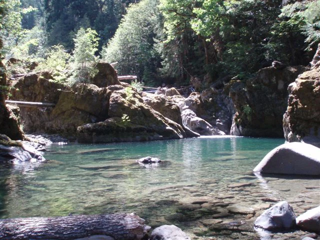
A calm, clear pool of water surrounded by mossy rocks and dense forest in the Middle Santiam Wilderness.
A serene pool along a creek within the Middle Santiam Wilderness.

Middle Santiam Wilderness history and protected-area timeline

Middle Santiam Wilderness was formally designated in 1984 as part of the expanding National Wilderness Preservation System in the Pacific Northwest. Its establishment reflected a growing recognition of the ecological value of the old-growth forests, river valleys, and volcanic terrain within the central Oregon Cascades.

The area had long been part of the broader Willamette National Forest, where national forest management practices shaped its use and protection over the preceding decades. Designation as wilderness placed it under a higher level of protection, limiting road-building, mechanized use, and resource extraction in order to preserve its wilderness character. The 1984 designation thus marked a turning point that locked in long-term protection for the area's ancient forests and river systems.

Middle Santiam Wilderness landscape and geographic character

The landscape of Middle Santiam Wilderness is a classic expression of the central Oregon Cascades, combining steep volcanic terrain with softer, forested lowlands. At higher elevations, the topography is rugged, with steep slopes, high ridges, and prominent peaks that give the wilderness much of its visual drama. As elevation decreases, the land softens into gently sloping and bench-like terrain, where glacial and river processes have shaped quieter basins and terraces.

The dominant landmarks of the area are Donaca Lake, the Middle Santiam River, and Chimney Peak, a 4,965-foot lava plug that rises conspicuously in the northwestern portion of the wilderness. The Middle Santiam River cuts through the area, shaping valleys and supporting the dense forest that surrounds it. To the south, the Menagerie Wilderness offers a related but distinct landscape, and the broader backdrop is shaped by the nearby volcanic mass of Mount Washington. The result is a compact but varied terrain where volcanic origins, watercourses, and forest cover all meet.

Middle Santiam Wilderness ecosystems, habitats, and plant life

Middle Santiam Wilderness is defined ecologically by its extensive old-growth coniferous forests, which are among the most mature in the central Cascades. Stands of Douglas-fir, western redcedar, and western hemlock dominate the lower elevations, where moist conditions and dense canopy create a deeply shaded forest environment. Some of these trees are estimated to be around 450 years old and reach heights of roughly 200 feet, making the wilderness ecologically significant in terms of both age and structural complexity.

At higher elevations and along ridgelines, the forest composition shifts toward true firs, which are better adapted to cooler conditions and shorter growing seasons. This vertical layering of forest types gives the wilderness a clear ecological gradient from lowland moist forest to subalpine coniferous stands. Wetlands, riparian corridors along the Middle Santiam River, and the still waters of Donaca Lake add further habitat diversity and contribute to the area's overall ecological richness.

The protection of these ecosystems within the Wilderness system helps preserve old-growth forest structure, intact riparian networks, and natural disturbance regimes that are increasingly rare in the surrounding landscape. As part of the broader Willamette National Forest, Middle Santiam Wilderness also functions as a key node in a wider network of forested Cascade habitat.

Middle Santiam Wilderness wildlife and species highlights

Wildlife in Middle Santiam Wilderness reflects the ecological character of a moist, old-growth Cascade forest environment. The dense canopy, fallen logs, and shaded streams provide habitat for forest-dependent species, while the river and lake systems support rich aquatic life. Native fish populations thrive in both the Santiam River and Donaca Lake, and Chinook salmon are notable during spawning season as they move into the watershed.

The surrounding old-growth forest offers roosting sites, denning structures, and foraging habitat for a range of forest birds and mammals typical of the central Cascades. The combination of intact forest cover and relatively undisturbed waterways makes the wilderness an important refuge for native wildlife within an otherwise heavily managed broader landscape.

Middle Santiam Wilderness conservation status and protection priorities

Middle Santiam Wilderness has strong conservation significance because of the age, continuity, and maturity of its forest cover. The designation of the area as wilderness in 1984 provided a long-term framework for protecting these old-growth stands, the river corridors that thread through them, and the volcanic terrain that shapes the watershed. Wilderness status limits road-building, mechanized use, and commercial activities that would otherwise fragment or degrade the forest.

The wilderness also contributes to broader conservation goals for the Willamette National Forest and the central Cascades by safeguarding ecological processes such as natural canopy succession, riparian function, and salmon-bearing streamflow. Its proximity to other protected areas, including the Menagerie Wilderness to the south, enhances its value as part of a connected network of Cascade habitats.

Top sights and standout views in Middle Santiam Wilderness

Standout features of Middle Santiam Wilderness include its ancient Douglas-fir, western redcedar, and western hemlock forests, some of which are estimated to be 450 years old. The scenic pairing of Donaca Lake and the 4,965-foot volcanic spire of Chimney Peak gives the area much of its visual signature, while the Middle Santiam River provides both ecological function and a defining valley axis. Its location within the Willamette National Forest, near Mount Washington and next to the Menagerie Wilderness, places it firmly within a landscape of classic central Cascade wilderness.

Best time to visit Middle Santiam Wilderness

The most rewarding seasons to experience Middle Santiam Wilderness are typically late spring through early autumn, when snow has receded from most of the area and forest trails, riverbanks, and lakeside settings become accessible. Summer brings the fullest expression of the old-growth forest understory, active stream conditions, and warmer approaches to Donaca Lake and the Middle Santiam River. Fall adds a distinctive atmosphere of changing weather and shifting light across the mossy forest and rugged volcanic terrain, while winter emphasizes the wilderness's remote and quiet character under snow at higher elevations.

Monthly climate preview

Long-term representative monthly averages for temperature and precipitation

Middle Santiam Wilderness Climate Normals and Annual Temperature Patterns

Representative coordinate measurements record the long-term annual temperature and precipitation rhythm across Middle Santiam Wilderness from 1991 to 2020. Examining the complete twelve-month climate profile reveals detailed monthly fluctuations in average temperature and precipitation.
Annual mean9 °C
3 °C18 °C
Jan
Feb
Mar
Apr
May11°
Jun13°
Jul18°
Aug18°
Sep16°
Oct10°
Nov
Dec
Warmest month
August

18.3 °C

Coolest month
December

2.7 °C

Wettest month
December

8.3 mm/day

Driest month
July

0.5 mm/day

Park location guide

Geography guide, regional context, and park location map for Middle Santiam Wilderness

Middle Santiam Wilderness park geography, regions, and map view in United States of America

Understand where Middle Santiam Wilderness sits in United States of America through a broader geographic reading of the surrounding landscape, nearby location context, and its mapped position within the national park landscape.

How Middle Santiam Wilderness fits into United States of America

The United States of America is a federal presidential republic and one of the world's largest countries by area and population. It consists of 50 states across a vast territory spanning multiple time zones, with its capital in Washington, D.C. and largest city in New York City. The nation has a diverse economy, influential political system, and significant cultural and military presence globally.

Wider geography shaping Middle Santiam Wilderness in United States of America

The United States occupies a vast territory in North America, bordered by Canada to the north and Mexico to the south. The 48 contiguous states stretch from the Atlantic to the Pacific Ocean, while Alaska occupies the northwestern region and Hawaii is an archipelago in the Pacific. The country encompasses diverse terrain including the Rocky Mountains, Appalachian Mountains, Great Plains, and extensive river systems.

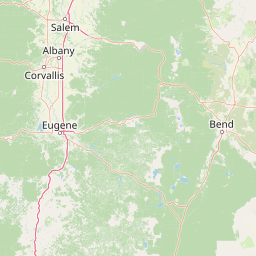
Map view of Middle Santiam Wilderness

Use this park location map to pinpoint Middle Santiam Wilderness in United States of America, understand its exact geographic position, and read its mapped placement within the surrounding landscape more clearly.

Pigeon | © OpenStreetMap contributors

Location context for Middle Santiam Wilderness

Linn CountyOregon
Recorded earthquake history

View Recorded Seismic Activity and Earthquake History in Middle Santiam Wilderness

Examine a structured catalogue of historical earthquake data associated with the Middle Santiam Wilderness area. MoriAtlas provides these records to help users visualize local seismic patterns and tectonic activity within this specific section of the Oregon Cascades.

Middle Santiam Wilderness Earthquake Records

Catalogued events

2 events

Strongest magnitude

Magnitude 4.4

Most recent event

Oct 7, 2022

This history includes earthquakes recorded inside the park or within 50 km of its borders

Examine old-growth forests, volcanic terrain, and river habitats through protected-area photography.

Middle Santiam Wilderness Photos and Landscapes: Visual Exploration of Oregon Cascades Scenery

Visual documentation reveals the ancient coniferous stands, rugged volcanic peaks, and glacial river basins defining Middle Santiam Wilderness. Photographic records provide clear spatial context for understanding the complex terrain and mature forest habitats spanning the central Oregon Cascades.

A calm, clear pool of water surrounded by mossy rocks and dense forest in the Middle Santiam Wilderness.

Park atlas

Compare adjacent forest reserves and volcanic terrain across the central Cascades

Parks Near Middle Santiam Wilderness And Related Protected Landscapes

Browsing other protected areas near Middle Santiam Wilderness reveals shared old-growth coniferous forests and rugged mountain topography. Expanding the regional comparison helps trace connected ecological corridors across the broader Willamette National Forest system.
Protected landscapeOregon
Park boundaries overlap#1 closest

South

Willamette National Forest: Geography and Protected Landscapes of the Central Oregon Cascades

Mapped terrain, old-growth forests, and protected wilderness boundaries.

Explore the expansive territory of Willamette National Forest, a primary protected area extending over 100 miles along Oregon's Cascade Range. This region features volcanic peaks exceeding 10,000 feet, extensive old-growth Douglas-fir stands, and a dense network of Wild and Scenic rivers, providing a detailed look at the geographic character and ecological heritage of the Pacific Northwest.

Area
6,790.75 km²
Established
1933
Visitors
1.7M annual
Relief
Mountain
Watercolor painting of a rolling mountain landscape with coniferous trees in the foreground and a hazy range of hills in the background.
Wildlife reserveOregon
About 9.1 km away#2 closest

South

Menagerie Wilderness Wildlife Reserve: Oregon Cascade Range Geography and Rock Pinnacles

Protected Cascade mountain terrain and unique crag clusters

Situated in the central Cascade Range of Oregon, Menagerie Wilderness provides a compact, highly defined landscape of rising rock pinnacles and lush coniferous forest. This resource traces the unique topography and protected boundaries of this specialized wilderness area, offering insight into the geological features and forest ecosystems that distinguish it from surrounding mountainous terrain.

Area
20.37 km²
Established
1984
IUCN
Ib
Relief
Mountain
A horizontal watercolor illustration showing a landscape with soft rolling mountains in the distance, a line of pine trees in the midground, and a grassy shoreline in the foreground.
Wildlife reserveOregon
22 km away#3 closest

Southeast

Mount Washington Wilderness: Volcanic Geology and Forested Cascade Terrain

A mapped overview of Oregon protected volcanic landscapes.

Mount Washington Wilderness offers a stark and compelling geological study of Oregon's central Cascades. From the shield volcano's basaltic remnants to the fragmented cinder cones of Belknap Crater, the area provides a window into explosive and effusive volcanic activity. Our geographic data maps the transition of conifer forests and subalpine zones across its rocky, lake-dotted interior, highlighting the unique character of this quiet protected preserve.

Area
219.66 km²
Established
1964
IUCN
Ib
Relief
Mountain
A watercolor painting showing a snowy mountain peak in the background rising above rolling green hills and pine forests in the foreground.
Protected landscapeOregon
30 km away#4 closest

Northeast

Mount Hood National Forest: Atlas of Protected Landscapes and Volcanic Geography

Exploring the Cascade Range terrain and wilderness boundaries in Oregon.

Mount Hood National Forest encompasses a vast, rugged expanse of the Oregon Cascades, anchored by the iconic, glacier-clad Mount Hood. This protected landscape contains extensive old-growth forests, high-alpine lakes, and deep river canyons. Discover the geographic extent of these wilderness areas and mountain terrain within the MoriAtlas database of protected lands.

Area
4,318.17 km²
Established
1908
Visitors
4.4M annual
Relief
Mountain
Wildlife reserveOregon
About 76 km away#5 closest

Northeast

Roaring River Wilderness: Geography and Protected Area Atlas of Oregon

Ancient forest corridors and alpine lake landscapes

Roaring River Wilderness is a federally protected landscape in Oregon, defined by steep, tree-covered ridges and the vigorous Roaring River. This wilderness preserves a dense mosaic of old-growth conifers, high-elevation alpine lakes like Serene and Shellrock, and important salmon-spawning waters within the broader Mount Hood National Forest geography.

Area
148 km²
Established
2009
IUCN
Ib
Relief
Mountain
Watercolor painting of a coastal landscape with sandy dunes, beach grasses in the foreground, and a dense treeline in the background.
Protected landscapeOregon
76 km away#6 closest

West

Siuslaw National Forest: Oregon Coast Range and Protected Landscape Geography

Coastal dunes, temperate rainforests, and river networks

Explore the mapped boundaries and natural geography of Siuslaw National Forest. This protected landscape highlights the ecological transition from Pacific shorelines to the high-elevation forests of the Oregon Coast Range, encompassing sand dune systems, salmon-supporting streams, and significant wilderness refuges.

Area
2,566.54 km²
Established
1908
Visitors
1M annual
Climate
Temperate
Protected landscapeOregon
83 km away#7 closest

Northeast

Mount Hood National Recreation Area: Oregon Protected Landscape and Regional Geography

A three-unit recreational forest landscape in the Cascade Range.

Spanning over 34,000 acres, this protected landscape frames the lower volcanic slopes and forested drainages around Mount Hood. The area integrates river corridors, wilderness boundaries, and subalpine terrain, offering a clear view of the complex topography that defines the Cascade Range in northern Oregon.

Area
139.8 km²
Established
2009
Relief
Mountain
Climate
Temperate
A watercolor painting showing a wide, panoramic view of a mountain range in the background, rolling green hills in the midground, and a small cluster of evergreen trees in the foreground against a white background.
Wildlife reserveOregon
83 km away#8 closest

Northeast

Mount Hood Wilderness: Atlas of Volcanic Peaks and Glacial Geography in Oregon

High-altitude protected landscapes and forest ecosystems

This protected area captures the dramatic character of the Cascade Range through its signature volcanic terrain, ancient forests, and high-alpine ridges. Covering a vast vertical range, the wilderness offers a study in geologic forces, featuring active glaciers, deep basaltic canyons, and meadows that define the mountain's northern and western slopes.

Area
262 km²
Established
1964
IUCN
Ib
Visitors
10K annual

Common questions about visiting, size, designation, and location context for Middle Santiam Wilderness

Middle Santiam Wilderness FAQs for park facts, access, geography, and protected area context

Find quick answers about Middle Santiam Wilderness, including protected-area facts, park geography, trail and visitor context, and how the park fits into its surrounding country and regional landscape.
MoriAtlas Explorer

Continue Your Protected Areas Search Across the Global Atlas

Deepen your exploration by continuing the structured search for national parks and protected areas worldwide. Utilize the comprehensive filtering capabilities to compare different conservation landscapes and refine your understanding of global park geography. Discover more about the distribution and characteristics of protected natural areas.

Global natural geography