

Mori Atlas logo
Natural monumentMilčice

A rare lowland wetland complex defined by mineralized tufa springs and specialized fen vegetation

Milčice Natural Monument: Mapping the Calcareous Spring Landscapes of Středočeský kraj

(Přírodní památka Milčice)

Milčice Natural Monument represents a protected enclave within the intensively farmed Sadská rovina of the Czech Republic. This four hectare site is defined by the emergence of alkaline groundwater that feeds small, tufa-forming springs along the Milčický potok. The landscape provides critical habitat for specialized spring and fen vegetation, serving as a vital botanical refuge within the broader Central Bohemian lowland geography.

calcareous springstufa seepageswet meadow remnantslowland wetlandspring fenCentral Bohemia
A flat-style vector illustration depicting a peaceful forest scene with white-barked birch trees, a calm lake, and soft-colored cliffs in the background.

Milčice

Natural monument

Park overview

Structured park overview, official facts, and landscape profile for Milčice Natural Monument

Milčice Natural Monument park facts, protected area profile, and essential visitor context

Review the core facts for Milčice Natural Monument, including designation, size, terrain, visitor scale, habitats, and operating context in one park-focused overview.

About Milčice Natural Monument

Milčice Natural Monument sits in one of the quietest, flattest parts of Bohemia, not far from the Elbe (Labe) River floodplain. From a landscape perspective, it is a humble place: a few hectares of low-lying ground near the village of Milčice, crossed by a shallow stream, dotted with small pools, and fringed by birch, spruce, pine, and aspen. Yet ecologically, it punches well above its size.

The defining character of the site is created by groundwater that rises through Cretaceous bedrock and Pleistocene sandy gravel terraces in a strongly mineralized, calcareous form. When this water emerges at the surface, it builds up deposits of pěnovec, a soft, porous tufa rock. Over the long term, these deposits and their associated soils create the wet, base-rich conditions that host rare spring and fen species.

The protected area also functions as a Natura 2000 site, formally tying the conservation of Milčice to the broader European network of important habitats. Together, the national monument designation and the Natura 2000 recognition ensure that this small but ecologically rich lowland spring system receives coordinated protection and management attention.

Quick facts and research context for Milčice Natural Monument

Milčice Natural Monument lies in the Nymburk district of the Středočeský kraj (Central Bohemian Region), in the cadastral territory of Milčice u Peček. It was declared a přírodní památka (natural monument) by the Regional Authority of the Central Bohemian Region, with protection taking effect on 15 March 2017.

The protected area covers approximately 4.08 hectares at an elevation of 189 to 193 meters above sea level, within the flat landscape of the Sadská rovina (Sadská plain) in the Nymburská kotlina basin. Milčice overlaps entirely with a Natura 2000 European Site of Community Importance of the same name. Its defining feature is a system of calcareous tufa springs that feed small open water bodies along the Milčický potok stream.

Protection and recognition

Designation history, terrestrial management scope, and Natura 2000 records

Milčice Protection Status and International Recognition Data

Milčice maintains official terrestrial protection status established in 2017 with documented Natura 2000 recognition records. Structured data details the legal designation history and management scope associated with the protected area.

International recognition

Protection details

Protection scope
Terrestrial
Designated year
2017
Transboundary protection
No
Park context

Deeper park guide and search-rich context for Milčice Natural Monument

Milčice Natural Monument history, landscape, wildlife, and travel context

Explore Milčice Natural Monument through its history, landscape character, ecosystems, wildlife, conservation priorities, cultural context, and seasonal travel timing in a structured park guide built for atlas discovery and search intent.

Why Milčice Natural Monument stands out

Milčice is known above all for its pěnovcová luční prameniště, calcareous tufa-forming meadow springs that are rare in the Czech lowlands. The water rising from these springs is strongly alkaline and rich in calcium, magnesium, and bicarbonates, and over time deposits tufa (travertine-like pěnovec) at the surface. This unusual hydrochemistry supports a specialized flora, including sedge species such as Carex davalliana and Carex viridula, the blunt-flowered rush (Juncus subnodulosus), seaside centaury (Centaurium littorale), and the adder's-tongue fern (Ophioglossum vulgatum). The combination of flat agricultural terrain, a straightened lowland stream, and a functioning calcareous spring system makes Milčice a regionally distinctive and ecologically meaningful site.
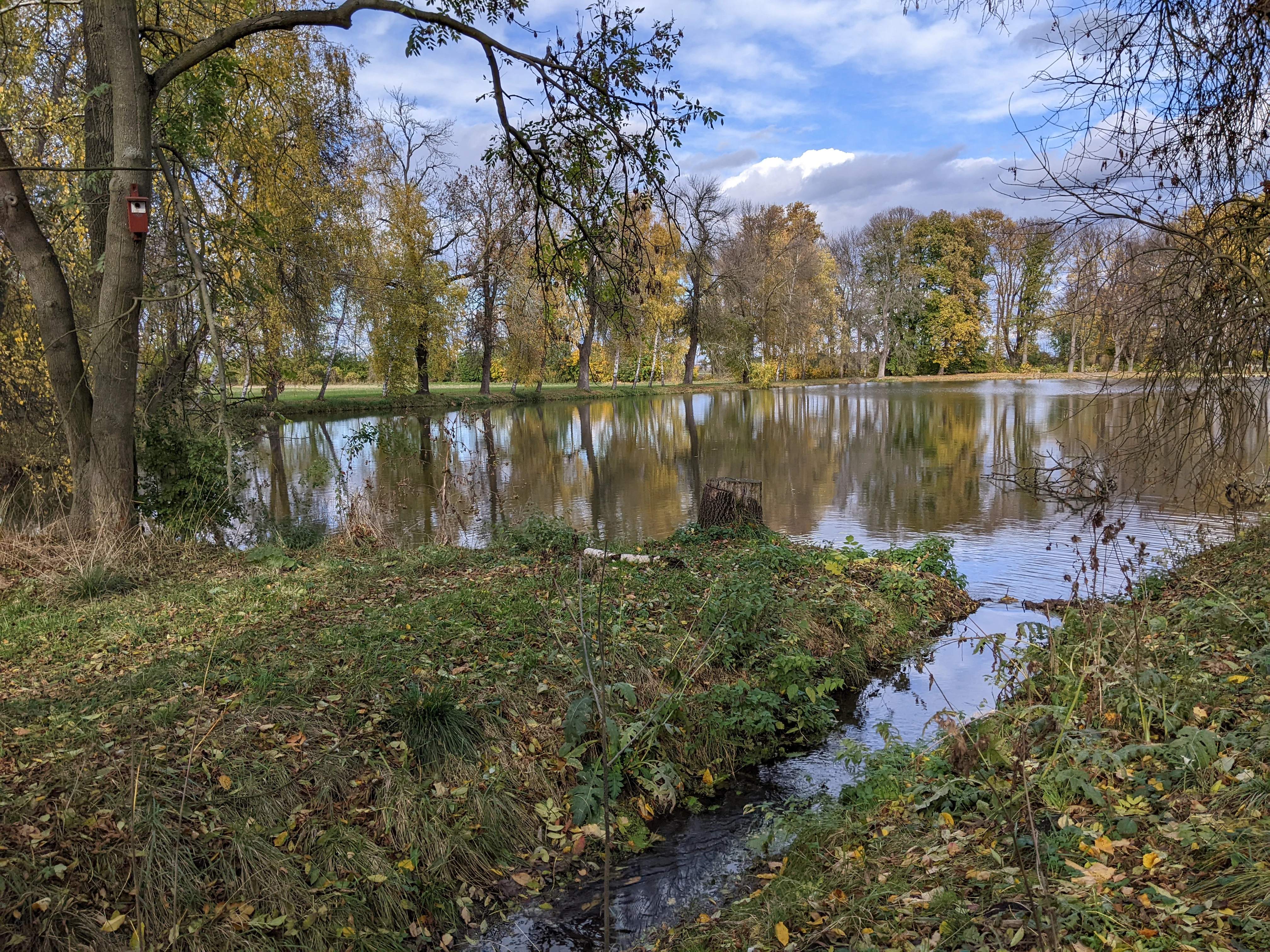
A small, calm pond surrounded by trees with yellow and green autumn leaves, with a stream flowing into the pond in the foreground.
A peaceful view of the pond and surrounding autumn vegetation at Milčice Nature Monument.

Milčice Natural Monument history and protected-area timeline

Until the mid-twentieth century, the territory of today's nature monument consisted of wet meadows surrounded by arable land. In the second half of the 1900s, local sediments were excavated, destroying the original wet meadow habitat along with much of its species richness. The springs themselves survived the disturbance, however, and spring vegetation gradually began to redevelop in their vicinity.

Non-waterlogged parts of the land were left to successional processes and became overgrown with shrubs and volunteer trees. Despite the species-poorer character that followed the historical disturbance, the surviving calcareous springs retained their ecological value. The Milčický potok, which passes through the area, had been channelized at least by the nineteenth century, altering the natural water regime.

Formal recognition finally came in 2017, when the Regional Authority of the Central Bohemian Region declared Milčice a přírodní památka (natural monument), with protection effective from 15 March 2017. Its overlap with a pre-existing Natura 2000 European Site of Community Importance gave the small site additional weight in national habitat conservation policy.

Milčice Natural Monument landscape and geographic character

Milčice lies in the Středolabská tabule (Middle Elbe Table), a wide, flat structural region of central Bohemia. More specifically, the site sits in the Nymburská kotlina basin and the Sadská rovina (Sadská plain) sub-unit, a landscape shaped largely by Pleistocene river terraces of the Elbe. The terrain is gently undulating at best, with elevations between roughly 189 and 193 meters.

A shallow valley has been cut into these terraces by the Milčický potok, and along this valley the protected area occupies a depressed patch of ground. The depression itself is partly flooded and partly fed by strong springs emerging along its southwestern edge. One branch of the channelized Milčický potok flows along the southern side of the monument and feeds a small pond just east of the protected boundary.

The result is a quiet agricultural lowland punctuated by a small, water-influenced hollow. Open water, moist mineral soil, scattered shrubs, and overhanging birch and pine give the place a distinctive character that contrasts subtly with the surrounding fields, without ever rising into dramatic scenery.
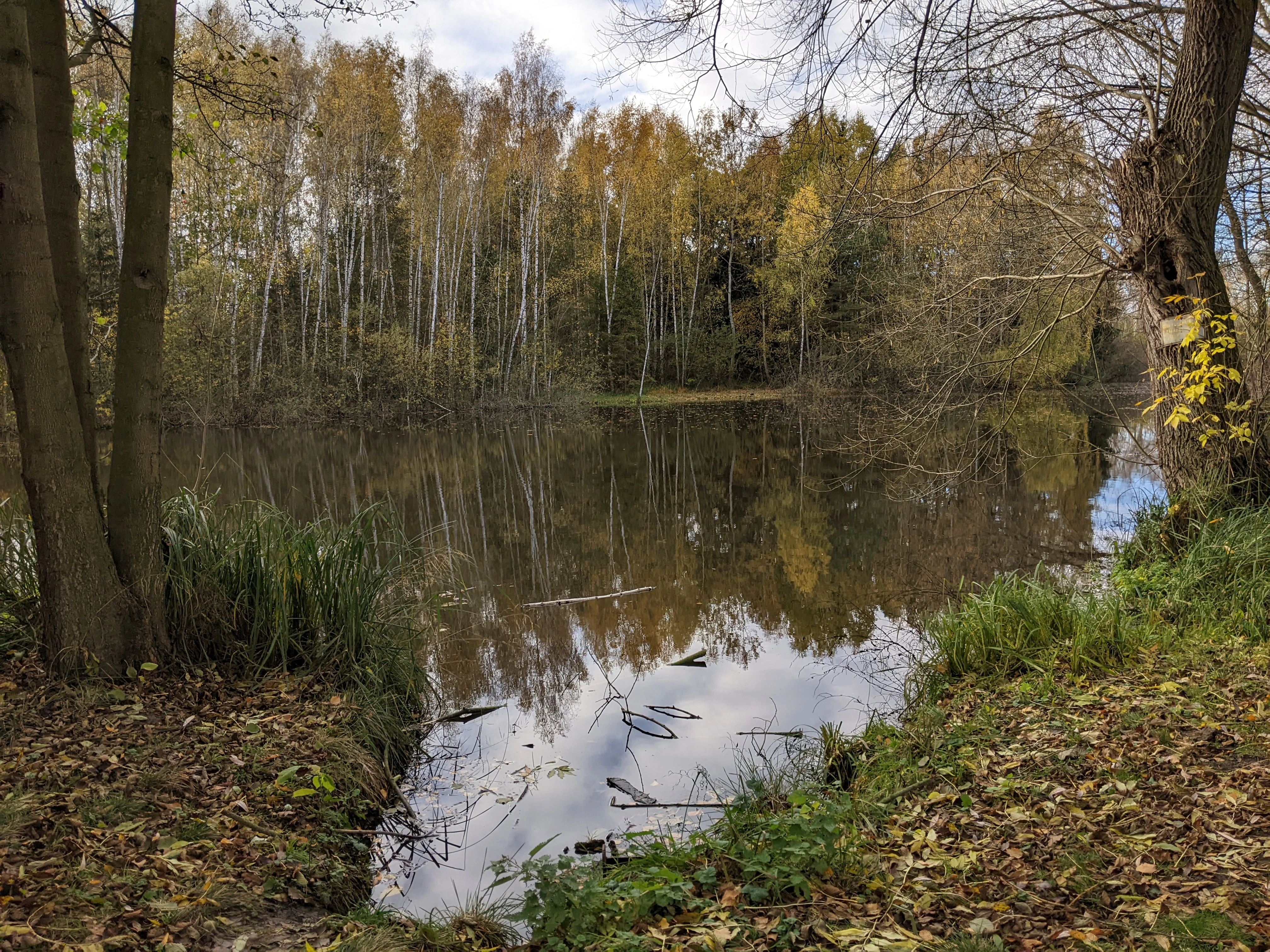
A peaceful, still pond reflecting the surrounding trees in autumn; the foreground features leaf-covered ground and trees on either side.
A calm, reflective pond surrounded by autumn trees at Milčice Natural Monument.

Milčice Natural Monument ecosystems, habitats, and plant life

The ecological identity of Milčice is built on a narrow strip of calcareous spring habitat surrounded by very different land uses. The spring system creates a small island of conditions where base-rich, mineralized groundwater keeps the soil permanently wet and chemically unusual for central Bohemia.

Within the springs themselves, the vegetation is species-poor compared to historical references but still botanically valuable. Characteristic species include blunt-flowered rush (Juncus subnodulosus), Davall's sedge (Carex davalliana), small-bracted sedge (Carex viridula), seaside centaury (Centaurium littorale), and the adder's-tongue fern (Ophioglossum vulgatum). These are stress-tolerant specialists of calcareous seepages rather than generalist meadow plants.

Around and between the springs, volunteer and planted tree stands of silver birch (Betula pendula), Norway spruce (Picea abies), Scots pine (Pinus sylvestris), and Eurasian aspen (Populus tremula) have developed, along with edges dominated by bush grass (Calamagrostis epigejos) and stinging nettle (Urtica dioica). Outside the actual springs, management aims to create additional shallow, water-filled depressions that can be colonized by competitively weak specialists from the existing spring flora.

Milčice Natural Monument wildlife and species highlights

Because Milčice is a small, habitat-specific lowland site, its wildlife interest is tightly linked to its spring and pond environment rather than to a broad range of habitat types. No dedicated faunal survey has been carried out, and detailed species inventories are not available in the source material.

The one vertebrate specifically mentioned is the agile frog (Rana dalmatina), whose presence has been recorded at the site. The ponds, spring pools, and moist margins also create habitat for typical lowland wetland fauna such as amphibians and aquatic invertebrates, even where these have not been formally documented. The open, water-rich character of the protected hollow, set within an intensively farmed agricultural matrix, makes the site primarily relevant for moisture-dependent species rather than for forest or large-mammal communities.

Milčice Natural Monument conservation status and protection priorities

Milčice is protected simultaneously as a Czech přírodní památka and as a Natura 2000 European Site of Community Importance, which strengthens its standing in national and European habitat conservation networks. The combination of designations reflects the site's core conservation value: surviving calcareous tufa springs in an agricultural landscape where such habitats are otherwise rare.

The main threats recognized for the site include drainage of the surrounding land, diversion of spring water into wells, excessive nutrient input, and either an absence of management or management that is too intensive, including heavy grazing or the passage of heavy machinery along the springs. Stream regulation works, including a 2015 revitalization of the channel feeding the pond east of the monument, have likely contributed to further deepening of the watercourse and may negatively influence the local water regime.

Management prescriptions focus on light, targeted intervention. Within the spring areas, only occasional removal of volunteer woody species is recommended, followed by clearing of cut biomass. Strongly competitive species such as common reed (Phragmites) and tall sedges should be controlled more aggressively. Outside the springs, shallow depressions on the order of a few to tens of square meters are to be dug out, so that flooding can give competitive advantage to the weak spring specialists. In the water bodies themselves, fish stocks, dominated by common carp (Cyprinus carpio), should be reduced, and recreational fishing concentrated along the less valuable northern shore.

Milčice Natural Monument cultural meaning and human context

The protected area takes its name from the small village of Milčice in the Nymburk district, and belongs to the cadastral territory of Milčice u Peček. Cultural context in the deeper sense is limited: the site is essentially a remnant natural feature embedded in an intensively farmed agricultural landscape shaped by the long history of settlement in the Middle Elbe lowlands.

The channelization of the Milčický potok, which had been completed no later than the nineteenth century, is a reminder that even very modest lowland streams in this region were historically reshaped to serve surrounding farmland. The mid-twentieth-century excavation of sediments that once destroyed the original wet meadows reflects the broader pattern of lowland drainage in Bohemia during that era.

Top sights and standout views in Milčice Natural Monument

The standout features of Milčice are concentrated and tightly defined. First, the calcareous tufa springs are the heart of the site: emerging along the southwestern edge, they feed small pools, deposit pěnovec, and set the chemical conditions for everything else that lives there. Second, the suite of specialist species, including Davall's sedge, blunt-flowered rush, seaside centaury, and adder's-tongue fern, gives the site botanical significance well beyond its tiny footprint.

Equally important is the dual protection regime: a national natural monument status combined with Natura 2000 recognition ensures that even a 4-hectare site in the middle of farmland receives sustained conservation attention. Finally, the site's setting within the otherwise flat and intensively used Sadská rovina makes it a small but telling example of how a surviving spring complex can anchor biodiversity in an agricultural lowland.

Best time to visit Milčice Natural Monument

Milčice lies in a warm climatic region of the Czech Republic, with average January temperatures around minus two to minus three degrees Celsius and average July temperatures of roughly 18 to 19 degrees. Winters bring between 100 and 110 frost days, while summers see around 50 to 60 summer days, and annual precipitation totals typically between 550 and 700 millimeters.

For visitors interested in the spring vegetation and tufa seepages, late spring through early summer tends to be the most rewarding period, when the specialized sedge, rush, and centaury species are in active growth and the wetland character of the site is most visible. The open water, pond margins, and frog habitat can also be appreciated in warmer months. In winter, the site may be quieter in terms of visible nature, though the persistence of flowing spring water amid the surrounding agricultural plain remains a distinctive feature year-round.


Monthly climate preview

Track representative temperature ranges and precipitation trends across twelve recorded months.

Milčice Climate Normals and Long-Term Monthly Weather Patterns

Examine the recorded long-term temperature swings and daily precipitation rhythms established for Milčice between 1991 and 2020. Reviewing the complete monthly climate profile helps clarify the full span of measured averages at this representative coordinate.
Annual mean9 °C
-2 °C20 °C
Jan-2°
Feb-1°
Mar
Apr
May14°
Jun18°
Jul20°
Aug19°
Sep14°
Oct
Nov
Dec-1°
Warmest month
July

19.8 °C

Coolest month
January

-2.5 °C

Wettest month
July

2.7 mm/day

Driest month
April

1.2 mm/day

Park location guide

Geography guide, regional context, and park location map for Milčice Natural Monument

Milčice Natural Monument park geography, regions, and map view in Czechia

Understand where Milčice Natural Monument sits in Czechia through a broader geographic reading of the surrounding landscape, nearby location context, and its mapped position within the national park landscape.

How Milčice Natural Monument fits into Czechia

Czech Republic is a landlocked Central European country with a population of approximately 10.9 million people. The nation was established as an independent state on January 1, 1993, following the dissolution of Czechoslovakia. Its capital and largest city is Prague, with other major urban centers including Brno, Ostrava, Plzeň, and Liberec.

Wider geography shaping Milčice Natural Monument in Czechia

The Czech Republic is a landlocked country in Central Europe. It is bordered by Germany to the west, Austria to the south, Poland to the northeast, and Slovakia to the southeast. The landscape is predominantly hilly, with the territory covering 78,871 square kilometers.

Map view of Milčice Natural Monument

Use this park location map to pinpoint Milčice Natural Monument in Czechia, understand its exact geographic position, and read its mapped placement within the surrounding landscape more clearly.

Pigeon | © OpenStreetMap contributors

Location context for Milčice Natural Monument

Středočeský kraj
Recorded earthquake history

Explore Recorded Seismic History and Earthquake Data for Milčice

Review a structured catalogue of historical earthquake events associated with the geography of Milčice. This resource provides clear access to event dates, magnitudes, and epicentre distances to support regional environmental study. Navigate these records to understand the documented seismic history of the surrounding Central Bohemian landscape.

Milčice Earthquake History

Catalogued events

2 events

Strongest magnitude

Magnitude 3.7

Most recent event

Oct 22, 1987

This history includes earthquakes recorded inside the park or within 50 km of its borders

Visualizing lowland habitats, spring fens, and tufa seepages across the reserve

Milčice Landscape Photos and Protected Area Scenery Exploration

Visual records capture the low-lying terrain, damp depressions, and spring-fed wetlands defining the protected landscape of Milčice. Examining these habitat views reveals how specialized vegetation thrives within an intensively farmed agricultural setting.

A small, calm pond surrounded by trees with yellow and green autumn leaves, with a stream flowing into the pond in the foreground.

A grove of trees including birch and willow in a natural setting with late autumn foliage and grasses on the ground.

A peaceful, still pond reflecting the surrounding trees in autumn; the foreground features leaf-covered ground and trees on either side.

Park atlas

Compare regional park geography and adjacent lowland protected landscapes

Exploring Parks Near Milčice and Protected Areas in the Surrounding Region

Browse other parks near Milčice and protected areas across the surrounding region to compare local lowland wetland habitats. Continued geographic exploration helps place specialized spring fen reserves into a broader regional conservation context.
A soft, horizontal watercolor painting showing a green meadow with scattered bushes, distant rolling hills, and a pale, warm-toned sky.
Natural monumentStředočeský kraj
6.9 km away#1 closest

Northwest

Slatinná louka u Velenky Natural Monument: Geography and Protected Meadow Landscape

Protected grassland terrain in the Středočeský kraj

Slatinná louka u Velenky preserves a rare fragment of alkaline fen meadow within the Czech lowlands. As a designated natural monument and part of the Natura 2000 network, it functions as a crucial habitat buffer. This atlas entry provides insight into the park's flat lowland geography and its role in maintaining regional biodiversity across the Polabí plain.

Area
0.038 km²
Established
2014
IUCN
IV
Relief
Lowland
A watercolor illustration depicting a panoramic landscape with a golden meadow in the foreground and soft green hills in the distance.
Protected landscapeStředočeský kraj
About 20 km away#2 closest

West

Přírodní park Škvorecká obora, Králičina: Protected Landscape and Regional Geography

Natural terrain and historic forest near the Prague boundary

Přírodní park Škvorecká obora, Králičina preserves a layered cultural and natural landscape characterized by the Výmola stream floodplain. The area functions as a vital forest habitat on the eastern edge of the Prague Plateau, integrating rare botanical sites with historical remnants of a centuries-old game enclosure.

Established
2009
Relief
Lowland
Climate
Temperate
Access
Easy access
A soft, light-filled watercolor painting of a rolling Czech landscape featuring deciduous trees, grassy meadows, and distant hills.
Natural monumentStředočeský kraj
23 km away#3 closest

Northwest

Slepeč Natural Monument: Protected Woodland Geography in the Central Bohemian Region

A rare botanical sanctuary in the Jizera basin.

The Slepeč natural monument represents a concentrated area of high botanical importance, shielding a remnant oak-hornbeam woodland from surrounding cultivation. Located in the Středočeský kraj, this site is renowned for housing diverse orchid species, including the lady's slipper, within a specialized microclimate found in the lowland terrain. Its protected status offers a unique look at forest conservation in an agricultural heartland.

Area
0.088 km²
Established
1984
IUCN
IV
Relief
Upland
A soft watercolor painting of a rural landscape with light green meadows and clusters of trees under a pale, washed-out sky.
Protected landscapePrague
About 28 km away#4 closest

West

Přírodní park Říčanka: Protected Landscape and Geographic Map of Eastern Prague

An analysis of rural corridors, aquatic systems, and forest terrain.

Přírodní park Říčanka preserves an extensive rural ribbon of meadows, arable fields, and woodland patches on the eastern edge of Prague. This structured overview details the park's topography, its historic fishpond chain along the Říčanský potok, and the various natural monuments that characterize this protected Czech landscape.

Area
4 km²
Established
1984
Relief
Lowland
Climate
Temperate
A watercolor painting showing a panoramic landscape with a rocky quarry ledge in the foreground, green hills in the midground, and soft, pastel colored rolling hills in the background.
Natural monumentPrague
About 29 km away#5 closest

West

Rohožník, lom v Dubči: Geological Natural Monument and Protected Landscape in Prague

Analyzing the Ordovician quartzite and tectonic rock exposures of the Prague Plateau

Rohožník, lom v Dubči serves as a crucial natural monument in the Prague region, protecting abandoned quarries that showcase clear M-shaped tectonic folds and thick quartzite deposits. This site acts as a living laboratory for geological history, connecting archaeological finds with dry grassland communities in an otherwise suburban-agricultural landscape on the edge of the capital.

Area
0.034 km²
Established
1988
IUCN
III
Relief
Upland
Natural monumentKrálovéhradecký kraj
29 km away#6 closest

East

Víno Natural Monument: Mapped Protected Landscapes and Geographic Overview

Protected oak and hornbeam forest in eastern Bohemia

Víno Natural Monument is a significant protected area within the Královéhradecký kraj region, focused on the conservation of century-old broadleaf woodland. This location preserves essential deadwood microhabitats and diverse plant species, offering a clear example of lowland forest ecology integrated into the cultivated landscape of eastern Bohemia.

Area
0.725 km²
Established
2013
IUCN
III
Relief
Lowland
A watercolor painting showing a panoramic view of a wetland area with reeds in the foreground and a forested ridge in the background.
Protected landscapeMladá Boleslav District
About 32 km away#7 closest

North

Přírodní park Chlum: Exploring the Geography of a Protected Czech Woodland Ridge

Mladá Boleslav District protected landscape analysis

Examine the structural character of Přírodní park Chlum, an asymmetric horst ridge in the Czech Republic that serves as a vital ecological corridor. This protected landscape preserves rare forest communities and geological features, providing essential habitat continuity across the surrounding agricultural lowlands of the Mladá Boleslav District.

Area
13.19 km²
Established
2000
Relief
Upland
Climate
Temperate
Natural monumentStředočeský kraj
About 33 km away#8 closest

South

Na Stříbrné Natural Monument: A Geological and Forest Sanctuary in Central Bohemia

Protected woodland and historical mining terrain

Spanning less than five hectares, Na Stříbrné represents a dense mosaic of metamorphic geology and vibrant woodland habitat. This protected area in Středočeský kraj showcases the persistence of forest flora like mezereon amidst historic industrial relics, offering a clear window into the varied terrain of the Czech landscape.

Area
0.048 km²
Established
1972
IUCN
IV
Relief
Upland

Common questions about visiting, size, designation, and location context for Milčice Natural Monument

Milčice Natural Monument FAQs for park facts, access, geography, and protected area context

Find quick answers about Milčice Natural Monument, including protected-area facts, park geography, trail and visitor context, and how the park fits into its surrounding country and regional landscape.
MoriAtlas Explorer

Continue Your Protected Areas Search Across the Global Atlas

Deepen your exploration by continuing the structured search for national parks and protected areas worldwide. Utilize the comprehensive filtering capabilities to compare different conservation landscapes and refine your understanding of global park geography. Discover more about the distribution and characteristics of protected natural areas.

Global natural geography