
Mori Atlas logo
Wildlife reserveMill Creek Wilderness

Explore deep volcanic canyons, towering rock pinnacles, and diverse forest plateaus across this high-country landscape

Mill Creek Wilderness: A Protected Wildlife Reserve in the Heart of the Oregon Ochoco Mountains

Mill Creek Wilderness preserves a dramatic stretch of the Ochoco National Forest, characterized by its distinctive volcanic geology and vertical relief. From the iconic two hundred foot tall Twin Pillars to the expansive meadows of Bingham Prairie, this protected area offers a look into the rugged terrain of central Oregon. The landscape is defined by perennial creek drainage patterns, ponderosa pine forests, and a network of ridges that provide insight into the inland Pacific Northwest mountain geography.

wilderness areaOchoco National Forestvolcanic plugscanyon countryponderosa pine forestlodgepole pine
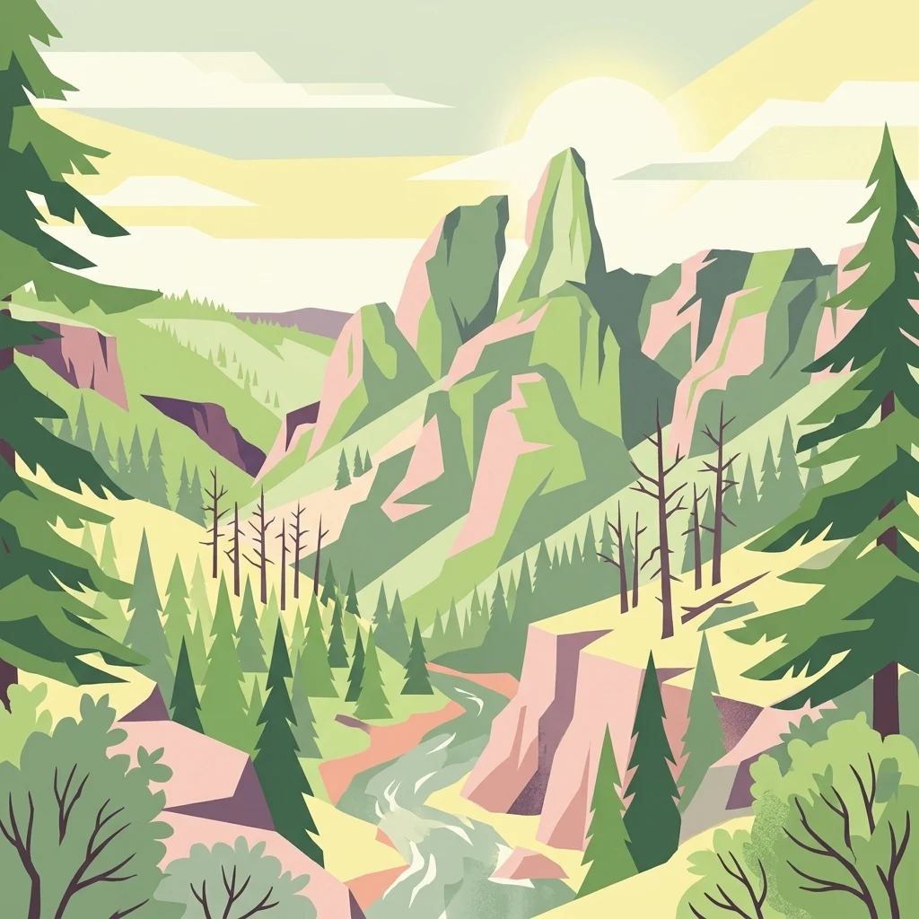
A stylized vector illustration of a forested canyon with a central winding river leading toward prominent, jagged volcanic rock spires under a soft, golden sky.

Mill Creek Wilderness

Wildlife reserve

Park overview

Structured park overview, official facts, and landscape profile for Mill Creek Wilderness

Mill Creek Wilderness park facts, protected area profile, and essential visitor context

Review the core facts for Mill Creek Wilderness, including designation, size, terrain, visitor scale, habitats, and operating context in one park-focused overview.

About Mill Creek Wilderness

Mill Creek Wilderness occupies a substantial block of protected backcountry in the heart of central Oregon's Ochoco Mountains. Managed as part of the Ochoco National Forest, it functions as one of the principal wilderness anchors in a region more often associated with juniper high desert and rolling rangeland. Within the broader national forest, it sits alongside Bridge Creek Wilderness and Black Canyon Wilderness, and it is the most extensive and most frequently visited of the three.

The terrain is strongly three-dimensional. Towering stone pinnacles, steep canyons, exposed ridge tops, and broad high-elevation meadows alternate across the landscape, producing a varied and visually dramatic setting. The northwestern corner, Bingham Prairie, is a nearly flat plateau of open meadows and lodgepole pine forest that contrasts sharply with the canyon country to the south and east. Mill Creek itself drains roughly eighty-five percent of the wilderness, with Marks Creek taking up the remaining share, and both creeks ultimately flow into Ochoco Creek.

Geologically, the area is especially notable for the Twin Pillars, two volcanic plugs that rise about 200 feet and have become an iconic feature of the wilderness. Thundereggs, the official state rock of Oregon, have been found in places such as Desolation Canyon and near the boundary at Steins Pillar, although active rockhounding is no longer permitted. Small surface gemstone mining claims still exist within the wilderness, accessed by primitive roads.

Ecologically, the wilderness is dominated by coniferous forest, with conifers covering the great majority of forested terrain. Lodgepole pine characterizes the Bingham Prairie plateau, while ponderosa pine forms an exemplary climax forest community across other parts of the area. The watershed, fire history, and recovered forest stands together give Mill Creek Wilderness an ecological profile that mixes dry inland conifer forest, post-fire regeneration, and high meadow openings. Its combination of wilderness character, accessible location near Prineville, and dramatic volcanic landmarks makes it an important component of Oregon's protected-area network.

Quick facts and research context for Mill Creek Wilderness

Mill Creek Wilderness is a roughly 17,400 acre wilderness area located in the Ochoco National Forest of central Oregon, within Crook County near the town of Prineville. It was officially designated in 1984 and is administered by the U.S. Forest Service, holding an IUCN Category Ib designation as a true wilderness area.

It is the largest and most heavily used of the three Ochoco wilderness areas, the others being Bridge Creek Wilderness and Black Canyon Wilderness. The landscape is dominated by Mill Creek drainage, with marks of both volcanic geology, including the Twin Pillars volcanic plugs, and the legacy of the Hash Rock Fire of 2000, which burned across the wilderness before partial recovery. The name itself traces to the first sawmill in Crook County, historically sited along Mill Creek.

Protection and recognition

Examine documented terrestrial conservation scopes and designation metrics for this protected area.

Mill Creek Wilderness Protection Status and Territorial Designation Records

Mill Creek Wilderness maintains a recorded terrestrial protection scope within official conservation inventories. Review structured designation data and administrative attributes associated with this protected landscape.

Protection details

Protection scope
Terrestrial
Transboundary protection
No
Park context

Deeper park guide and search-rich context for Mill Creek Wilderness

Mill Creek Wilderness history, landscape, wildlife, and travel context

Explore Mill Creek Wilderness through its history, landscape character, ecosystems, wildlife, conservation priorities, cultural context, and seasonal travel timing in a structured park guide built for atlas discovery and search intent.

Why Mill Creek Wilderness stands out

Mill Creek Wilderness is best known for its striking volcanic-plug scenery, especially the Twin Pillars, a pair of columnar rock formations that tower roughly 200 feet above the canyon country in the northwestern part of the wilderness. These pinnacles, together with the broader terrain of towering stone spires, steep canyons, and exposed ridgetops, give the area a distinctive, almost sculptural high-country character uncommon elsewhere in central Oregon. Equally defining is the wilderness's mixed forest identity, anchored by old-growth-style ponderosa pine climax communities on recovering slopes and lodgepole pine parkland across the Bingham Prairie plateau. Mill Creek Wilderness is also recognized as one of the chief recreation destinations within the Ochoco National Forest, drawing visitors for backcountry hiking, big game hunting, trout fishing, and exploration of the region's unusual volcanic and Thunderegg-bearing geology.
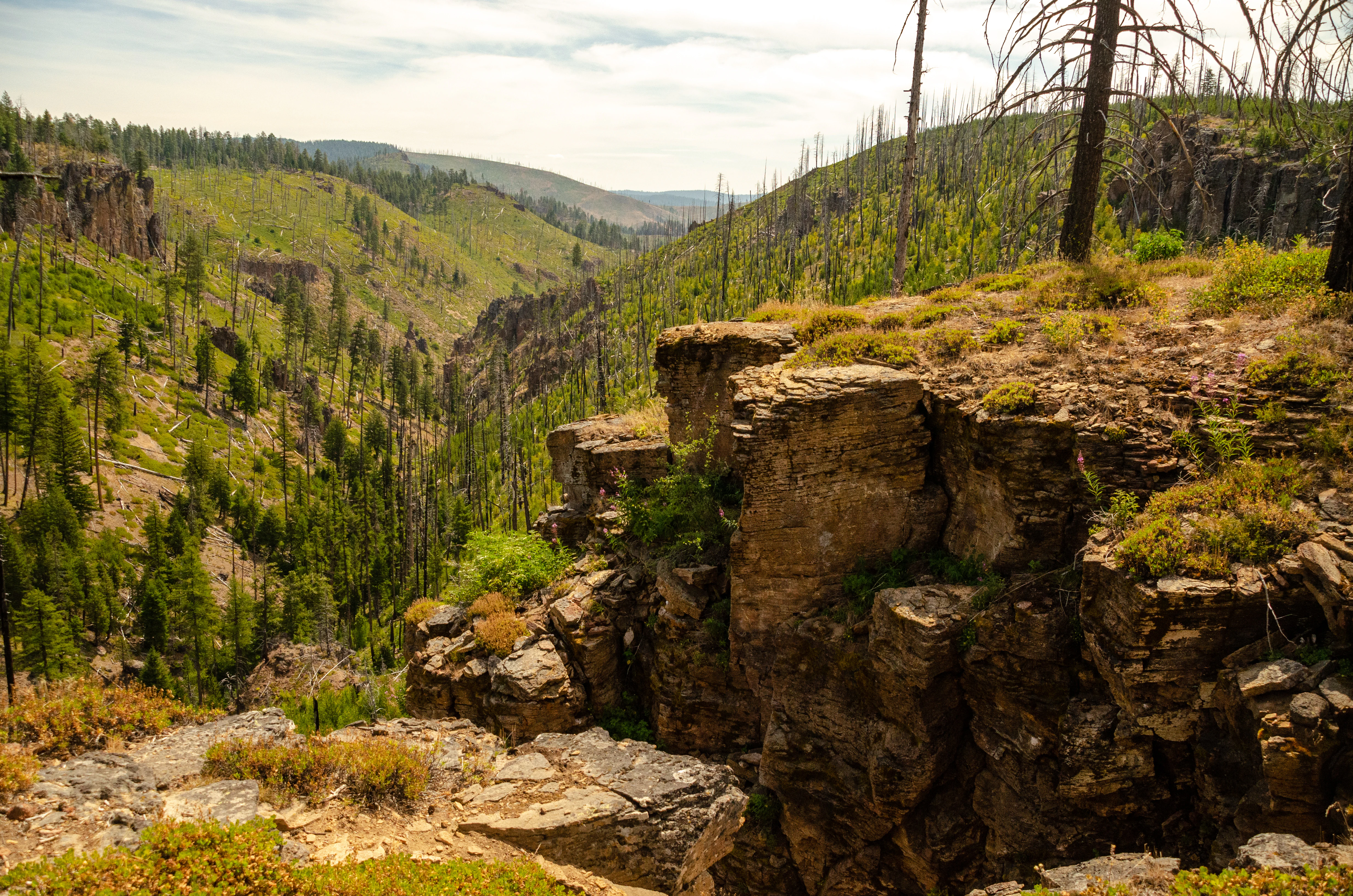
A high angle view looking down into a green forested canyon with rocky cliff walls and scattered dead trees from a previous burn.
A view looking down into the rugged canyon landscape of the Mill Creek Wilderness.

Mill Creek Wilderness history and protected-area timeline

The name Mill Creek Wilderness reflects a chapter of central Oregon history that predates any modern conservation designation. The first sawmill in Crook County was located along Mill Creek, and the drainage that gives the wilderness its name has long been closely associated with the region's pioneer-era timber and ranching industry. This naming legacy anchors the wilderness in the early economic history of the surrounding high desert plateau.

In the modern era, the area gained formal protection in 1984, when Mill Creek was designated as a federal wilderness area within the Ochoco National Forest. The designation placed the landscape under the higher protection standards of the National Wilderness Preservation System and established the area as the largest of the three designated wildernesses in the forest.

A pivotal event in the wilderness's recent history was the Hash Rock Fire of August and September 2000, which burned a significant portion of the wilderness. Since then, the burned landscape has largely recovered, and the area now includes an exemplary climax forest of ponderosa pine that reflects its long-term ecological trajectory. Today, the wilderness's history is read both through the early sawmill heritage of its name and through the more recent story of fire, recovery, and formal wilderness protection.

Mill Creek Wilderness landscape and geographic character

Mill Creek Wilderness showcases some of the most visually distinctive canyon and rock-formation scenery within central Oregon's Ochoco Mountains. Stone pinnacles rise abruptly from the terrain, including the famous Twin Pillars in the northwestern part of the wilderness, which stand roughly 200 feet tall as twin volcanic plugs. Around them, steep canyons, barren ridge tops, and scattered high meadows create an alternating rhythm of elevation, exposure, and sheltered draws.

In contrast to the rugged central terrain, the northwestern corner of the wilderness hosts Bingham Prairie, an almost level plateau covered in open meadows and lodgepole pine forest. This plateau forms a broad, open counterpoint to the canyon country, giving the wilderness a sense of spatial variety within a relatively compact footprint.

The hydrological framework reinforces the landscape's character. Mill Creek drains roughly eighty-five percent of the wilderness, with Marks Creek carrying the remainder, and both creeks serve as tributaries of the larger Ochoco Creek system. These perennial streams have carved the canyon profiles that define much of the terrain and continue to shape soil patterns and vegetation distribution across the area.
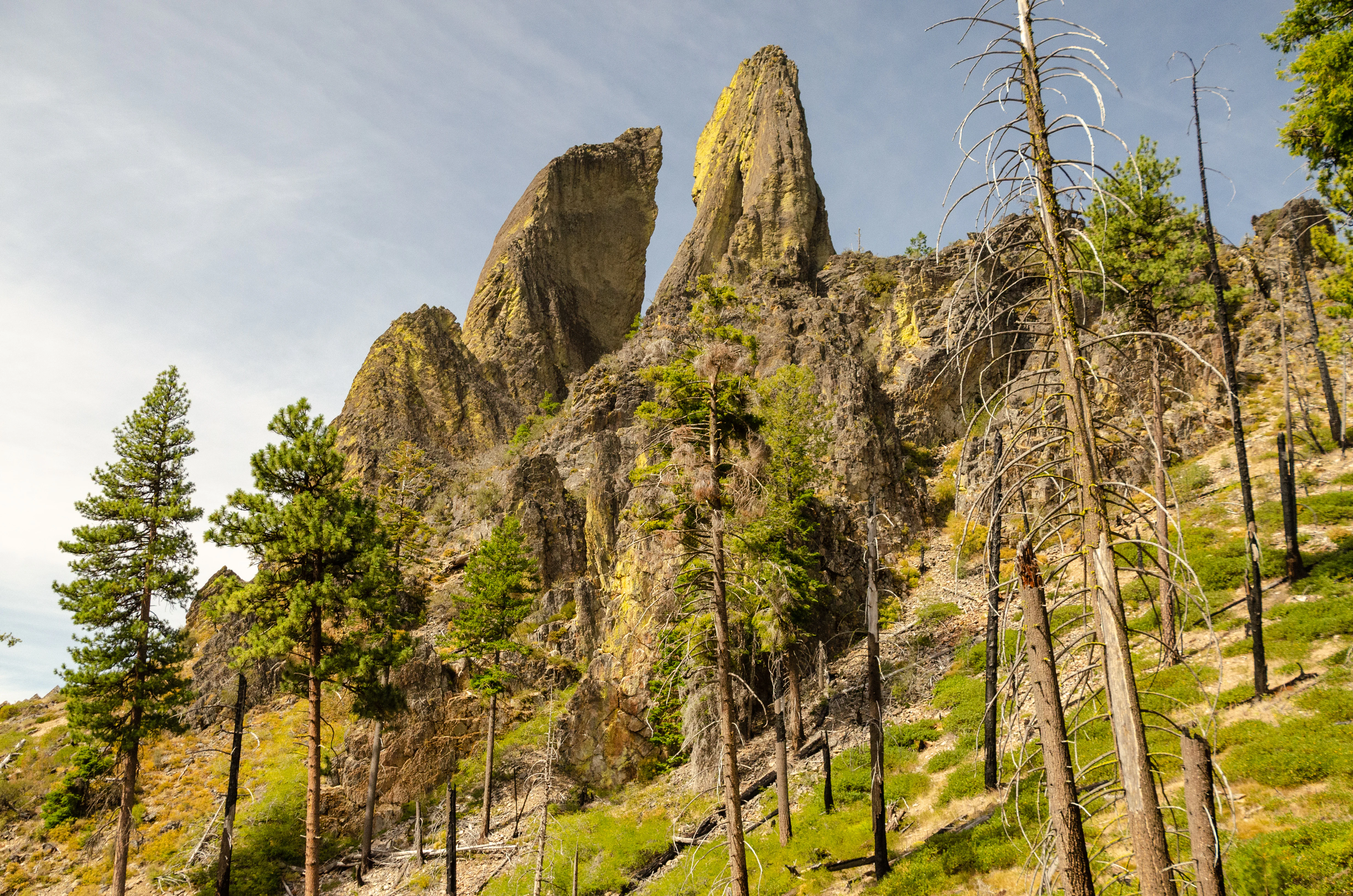
A low-angle view of the Twin Pillars rock formation, two distinct volcanic rock spires rising above a forest slope containing both healthy and fire-damaged dead trees.
The Twin Pillars rock formation rising above a hillside with burned and standing trees in Mill Creek Wilderness.

Mill Creek Wilderness ecosystems, habitats, and plant life

Mill Creek Wilderness is characterized by a predominantly coniferous forest cover that accounts for roughly eighty-five percent of its forested environment. Conifers shape nearly every aspect of the wilderness's plant communities, from the plateau parkland of the northwest to the canyon-side slopes further south and east.

Bingham Prairie, in the northwestern corner of the wilderness, supports open meadows interspersed with lodgepole pine forest, much of which has experienced attack from the mountain pine beetle, contributing to tree mortality across the plateau. Elsewhere, the wilderness contains an exemplary climax forest community of ponderosa pine, representing a mature and ecologically significant stage of dry inland conifer development.

The herbaceous layer includes a mix of native and non-native grasses, aster species, bull thistle, and snowberry, contributing to seasonal ground cover across meadows and openings. The wilderness's plant communities reflect the intersection of volcanic geology, fire history, and dry central Oregon climate, with the post-Hash Rock Fire recovery adding a dynamic element to the present-day pattern of vegetation and habitat succession.

Mill Creek Wilderness wildlife and species highlights

The wildlife profile of Mill Creek Wilderness reflects the broader interior Pacific Northwest pattern of dry coniferous forest mixed with meadow, canyon, and riparian habitats. Mammals such as black bear, mule deer, elk, bobcat, and mountain lion move through the area, taking advantage of the mix of forested slopes, ridgetops, and meadow openings.

Birdlife is similarly varied, with pileated woodpecker, northern goshawk, and wild turkey recorded across the wilderness. The combination of mature ponderosa pine, recovering lodgepole stands, and riparian corridors along Mill Creek and Marks Creek supports a diverse range of cavity-nesting, forest-interior, and edge species.

The wilderness is also notable for its recreational wildlife use. Big game hunting is popular in the fall, and anglers seek the small rainbow trout that inhabit the area's perennial streams. Together, these wildlife patterns reinforce the wilderness's role as both a refuge for native species and a working landscape for traditional outdoor recreation.

Mill Creek Wilderness conservation status and protection priorities

Mill Creek Wilderness carries significant conservation value as one of three designated wilderness areas within the Ochoco National Forest and the largest among them. Its IUCN Category Ib designation reflects the highest level of legal protection available within the national forest system, emphasizing the preservation of wilderness character over development or intensive management.

Ecologically, the wilderness protects a continuous block of dry inland conifer forest, including an exemplary ponderosa pine climax community and an extensive lodgepole pine plateau. The protection of these mature forest types, along with the area's canyon and meadow habitats, contributes to landscape-scale connectivity and long-term forest resilience in the Ochoco Mountains.

Fire is an important part of the conservation story. The Hash Rock Fire of 2000 burned across a significant portion of the wilderness, and the subsequent recovery provides an ongoing case study in post-fire forest regeneration. The wilderness's mix of recovering burned stands, mature climax forest, and unchanged plateau meadows offers a valuable natural laboratory for understanding disturbance, succession, and resilience in central Oregon's dry forest ecosystems.

Mill Creek Wilderness cultural meaning and human context

Mill Creek Wilderness carries a cultural identity rooted in the early settlement and resource use of Crook County, Oregon. The wilderness's name commemorates the first sawmill in the county, historically located along Mill Creek, and reflects the importance of small-scale timber operations and ranching in the early economic life of the area.

This pioneer-era heritage gives the wilderness a local meaning that goes beyond its modern ecological role, tying the protected landscape back to the working history of central Oregon's high desert communities. While the wilderness today is primarily valued for its natural and recreational character, the underlying place name preserves a tangible link to Crook County's nineteenth and early twentieth century land use patterns.

Top sights and standout views in Mill Creek Wilderness

Mill Creek Wilderness is distinguished by the dramatic vertical relief of the Twin Pillars volcanic plugs, which rise roughly 200 feet above the surrounding terrain and have become the visual signature of the area. The juxtaposition of rugged canyon country with the flat, open Bingham Prairie plateau gives the wilderness an unusually varied topography for its size.

Its ecological highlights include an exemplary ponderosa pine climax forest, extensive lodgepole pine stands recovering from both beetle activity and the Hash Rock Fire, and a network of perennial streams that support native trout. As the largest of the Ochoco National Forest's three wilderness areas, Mill Creek also stands out for its combination of protected character, recreational opportunity, and accessible location near Prineville.

Best time to visit Mill Creek Wilderness

Mill Creek Wilderness offers distinct seasonal experiences shaped by central Oregon's dry continental climate. Summer and early fall are typically the most favorable periods for hiking and canyon exploration, when the snow has melted from the higher elevations and the Twin Pillars area, ridge tops, and meadow trails are most accessible. Cooler nights and generally dry conditions make this window the most comfortable for backcountry travel.

Fall brings additional appeal through big game hunting season, when elk, mule deer, and other wildlife are more visible across the meadows and forested slopes, while spring can offer green-up in the meadows and active stream conditions for anglers, although higher elevations may still hold lingering snow and variable weather. Winter conditions are generally harsh in this high-country terrain and are usually less suitable for casual exploration.
Monthly climate preview

Long-term temperature ranges and precipitation averages measured across twelve distinct months

Mill Creek Wilderness Climate Normals and Monthly Weather Patterns in Oregon

Representative coordinate records show average temperatures shifting from sub-zero winter minimums to warm summer maximums alongside varying monthly precipitation rates. Detailed monthly comparisons provide complete climatological context for studying long-term environmental patterns across the protected terrain.
Annual mean8 °C
-1 °C19 °C
Jan-1°
Feb
Mar
Apr
May11°
Jun14°
Jul19°
Aug18°
Sep14°
Oct
Nov
Dec-1°
Warmest month
July

18.8 °C

Coolest month
December

-1.2 °C

Wettest month
December

2.2 mm/day

Driest month
July

0.4 mm/day

Park location guide

Geography guide, regional context, and park location map for Mill Creek Wilderness

Mill Creek Wilderness park geography, regions, and map view in United States of America

Understand where Mill Creek Wilderness sits in United States of America through a broader geographic reading of the surrounding landscape, nearby location context, and its mapped position within the national park landscape.

How Mill Creek Wilderness fits into United States of America

The United States of America is a federal presidential republic and one of the world's largest countries by area and population. It consists of 50 states across a vast territory spanning multiple time zones, with its capital in Washington, D.C. and largest city in New York City. The nation has a diverse economy, influential political system, and significant cultural and military presence globally.

Wider geography shaping Mill Creek Wilderness in United States of America

The United States occupies a vast territory in North America, bordered by Canada to the north and Mexico to the south. The 48 contiguous states stretch from the Atlantic to the Pacific Ocean, while Alaska occupies the northwestern region and Hawaii is an archipelago in the Pacific. The country encompasses diverse terrain including the Rocky Mountains, Appalachian Mountains, Great Plains, and extensive river systems.

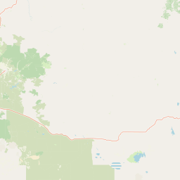
Map view of Mill Creek Wilderness

Use this park location map to pinpoint Mill Creek Wilderness in United States of America, understand its exact geographic position, and read its mapped placement within the surrounding landscape more clearly.

Pigeon | © OpenStreetMap contributors

Location context for Mill Creek Wilderness

Oregon

Explore protected terrain, volcanic stone pillars, and high forest habitats

Mill Creek Wilderness Photos and Landscapes: Visualizing Central Oregon Scenery

Visual documentation reveals the deep canyons, exposed stone spires, and ponderosa pine forests defining the protected landscape. Examining these field photographs provides a clearer understanding of the varied topography and high country environment within the reserve.

A high angle view looking down into a green forested canyon with rocky cliff walls and scattered dead trees from a previous burn.

A close up view of a wooden park sign with engraved text that reads Mill Creek Wilderness and Ochoco National Forest, set against a background of coniferous trees.

A low-angle view of the Twin Pillars rock formation, two distinct volcanic rock spires rising above a forest slope containing both healthy and fire-damaged dead trees.

Park atlas

Continue comparing central Oregon mountain terrain and neighboring protected landscapes.

Explore Other Parks Near Mill Creek Wilderness and Surrounding Protected Areas

Browsing other parks near Mill Creek Wilderness reveals the wider volcanic geography and forest ecosystems of the surrounding region. Comparing these protected landscapes helps trace regional elevation patterns, canyon formations, and high plateau habitats across central Oregon.
Protected areaOregon
Park boundaries overlap#1 closest

East

Ochoco National Forest: Mapping the Rugged Canyons and High Desert of Central Oregon

A vast protected area defined by rimrock plateaus and pine-forest watersheds.

Located in the heart of the Ochoco Mountains, this protected landscape offers a study in ecological contrast. From its dense ponderosa pine groves to the exposed volcanic ridges of the high desert, the forest acts as a critical habitat corridor for mule deer and elk, while protecting the headwaters of the North Fork Crooked River within a diverse, multi-terrain framework.

Area
3,444.01 km²
Established
1911
Visitors
575K annual
Relief
Mountain
A horizontal watercolor painting showing a panoramic view of layered green and purple mountains under a pale sky, with coniferous trees in the foreground.
Protected landscapeOregon
74 km away#2 closest

East

Malheur National Forest: Exploring Oregon's Vast Protected Mountain and Desert Landscape

A geographic study of the Blue Mountains and high desert terrain

Spanning over 1.4 million acres, Malheur National Forest represents a complex protected landscape in eastern Oregon. Its geography is defined by a central spine of the Strawberry Mountains, creating a transition zone between arid high desert ecosystems and dense coniferous forests. Known for large wilderness areas and extensive old growth stands, this forest serves as a vital point for understanding the interplay between topographic elevation and regional climate in the Pacific Northwest.

Area
5,929.81 km²
Established
1908
Visitors
242K annual
Relief
Mountain
A watercolor painting showing a snowy mountain peak in the background rising above rolling green hills and pine forests in the foreground.
Protected landscapeOregon
90 km away#3 closest

Northwest

Mount Hood National Forest: Atlas of Protected Landscapes and Volcanic Geography

Exploring the Cascade Range terrain and wilderness boundaries in Oregon.

Mount Hood National Forest encompasses a vast, rugged expanse of the Oregon Cascades, anchored by the iconic, glacier-clad Mount Hood. This protected landscape contains extensive old-growth forests, high-alpine lakes, and deep river canyons. Discover the geographic extent of these wilderness areas and mountain terrain within the MoriAtlas database of protected lands.

Area
4,318.17 km²
Established
1908
Visitors
4.4M annual
Relief
Mountain
A horizontal watercolor illustration showing a landscape with soft rolling mountains in the distance, a line of pine trees in the midground, and a grassy shoreline in the foreground.
Wildlife reserveOregon
96 km away#4 closest

West

Mount Washington Wilderness: Volcanic Geology and Forested Cascade Terrain

A mapped overview of Oregon protected volcanic landscapes.

Mount Washington Wilderness offers a stark and compelling geological study of Oregon's central Cascades. From the shield volcano's basaltic remnants to the fragmented cinder cones of Belknap Crater, the area provides a window into explosive and effusive volcanic activity. Our geographic data maps the transition of conifer forests and subalpine zones across its rocky, lake-dotted interior, highlighting the unique character of this quiet protected preserve.

Area
219.66 km²
Established
1964
IUCN
Ib
Relief
Mountain
Protected landscapeOregon
98 km away#5 closest

West

Willamette National Forest: Geography and Protected Landscapes of the Central Oregon Cascades

Mapped terrain, old-growth forests, and protected wilderness boundaries.

Explore the expansive territory of Willamette National Forest, a primary protected area extending over 100 miles along Oregon's Cascade Range. This region features volcanic peaks exceeding 10,000 feet, extensive old-growth Douglas-fir stands, and a dense network of Wild and Scenic rivers, providing a detailed look at the geographic character and ecological heritage of the Pacific Northwest.

Area
6,790.75 km²
Established
1933
Visitors
1.7M annual
Relief
Mountain
Protected landscapeOregon
111 km away#6 closest

Northwest

Mount Hood National Recreation Area: Oregon Protected Landscape and Regional Geography

A three-unit recreational forest landscape in the Cascade Range.

Spanning over 34,000 acres, this protected landscape frames the lower volcanic slopes and forested drainages around Mount Hood. The area integrates river corridors, wilderness boundaries, and subalpine terrain, offering a clear view of the complex topography that defines the Cascade Range in northern Oregon.

Area
139.8 km²
Established
2009
Relief
Mountain
Climate
Temperate
A watercolor painting showing a wide, panoramic view of a mountain range in the background, rolling green hills in the midground, and a small cluster of evergreen trees in the foreground against a white background.
Wildlife reserveOregon
115 km away#7 closest

Northwest

Mount Hood Wilderness: Atlas of Volcanic Peaks and Glacial Geography in Oregon

High-altitude protected landscapes and forest ecosystems

This protected area captures the dramatic character of the Cascade Range through its signature volcanic terrain, ancient forests, and high-alpine ridges. Covering a vast vertical range, the wilderness offers a study in geologic forces, featuring active glaciers, deep basaltic canyons, and meadows that define the mountain's northern and western slopes.

Area
262 km²
Established
1964
IUCN
Ib
Visitors
10K annual
Wildlife reserveOregon
127 km away#8 closest

West

Middle Santiam Wilderness: Geographic Atlas and Protected Landscape Overview of the Oregon Cascades

Old-growth forest basins and volcanic landmarks in the Willamette National Forest.

Middle Santiam Wilderness represents a distinct segment of the central Oregon Cascades. The area is defined by its substantial old-growth coniferous forests, including 450-year-old Douglas-fir and western hemlock stands, alongside the striking 4,965-foot volcanic plug known as Chimney Peak. This map-focused record traces the river-cut valleys and high-ridge topography that shape this protected habitat.

Area
34.57 km²
Established
1984
IUCN
Ib
Relief
Mountain

Common questions about visiting, size, designation, and location context for Mill Creek Wilderness

Mill Creek Wilderness FAQs for park facts, access, geography, and protected area context

Find quick answers about Mill Creek Wilderness, including protected-area facts, park geography, trail and visitor context, and how the park fits into its surrounding country and regional landscape.
MoriAtlas Explorer

Continue Your Protected Areas Search Across the Global Atlas

Deepen your exploration by continuing the structured search for national parks and protected areas worldwide. Utilize the comprehensive filtering capabilities to compare different conservation landscapes and refine your understanding of global park geography. Discover more about the distribution and characteristics of protected natural areas.

Global natural geography