Mori Atlas logo
Protected landscapeModoc National Forest

Mapping the geographic diversity of ancient lava flows and high elevation conifer forests

Modoc National Forest: A Vast Protected Landscape of Volcanic Plateaus and Alpine Wilderness

Modoc National Forest spans over 1.6 million acres of northeastern California, protecting a remote and distinct high-desert region shaped by geologic activity. This protected landscape features an intricate mosaic of terrain, ranging from sagebrush-covered plateaus and volcanic basins to the rising ridges of the Warner Mountains. The area remains a crucial conservation expanse, preserving old-growth pine and fir stands that contrast sharply with the surrounding semi-arid terrain.

national forestvolcanic landscapeWarner Mountainssagebrush steppeold-growth forestconifer forests

Modoc National Forest

Protected landscape

Park overview

Structured park overview, official facts, and landscape profile for Modoc National Forest

Modoc National Forest park facts, protected area profile, and essential visitor context

Review the core facts for Modoc National Forest, including designation, size, terrain, visitor scale, habitats, and operating context in one park-focused overview.

About Modoc National Forest

Modoc National Forest occupies a largely overlooked but geographically dramatic corner of California, far from the state's coastal population centers. It covers roughly 1.65 million acres across three counties, with the great majority of its acreage in Modoc County and smaller portions in Lassen and Siskiyou counties. The nearest major community and the location of the forest headquarters is Alturas, a small county seat that also reflects the rural, wide-open character of the surrounding region.

The defining physical setting of the forest is its volcanic substrate. Vast lava flows across the past 500,000 years have shaped much of the underlying geology, leaving rocky soils, basalt outcrops, and broad tablelands that influence both drainage and vegetation. In the eastern part of the forest, this plateau rises into the Warner Mountains, an isolated range whose eastern slopes drop steeply while the western flank ascends more gently toward forested summits.

Ecologically, the forest captures a full altitudinal gradient, from dry, brush-dominated foothills through mixed conifer forests to high-elevation pine types. This gradient supports a wide variety of plant communities and contributes to the forest's designation as a key reservoir of biodiversity in northeastern California. Within its boundaries lies the South Warner Wilderness, one of the designated Wilderness Areas protected by Congress, as well as significant tracts of old-growth conifer forest that have developed over many decades of relatively undisturbed growth.

Culturally, the forest is named for the Modoc people, who historically inhabited this part of present-day California and Oregon. The choice of name reflects both the geographic setting and the deep human history of the region. Today, Modoc National Forest functions as a working landscape managed for multiple uses, including conservation, recreation, grazing, and timber, while still serving as one of the defining natural features of California's northeastern interior.

Quick facts and research context for Modoc National Forest

Modoc National Forest is a federally managed national forest in northeastern California, administered by the U.S. Forest Service and headquartered in Alturas. The forest spans roughly 1.65 million acres and is distributed across Modoc County, with smaller portions extending into Lassen and Siskiyou counties.

The terrain combines high volcanic plateaus, sage-covered foothills, and the steep eastern slope of the Warner Mountains. Vegetation ranges from brushy bitterbrush and curl-leaf mahogany communities in the lowlands to mixed conifer forests of ponderosa pine, white fir, red fir, incense cedar, and aspen at mid- and high elevations. Designated wilderness such as the South Warner Wilderness lies within its boundaries, and the forest contains thousands of acres of inventoried old growth.

Protection and recognition

Documented terrestrial protection scope and official designation records for Modoc National Forest

Modoc National Forest Protection Status and International Recognition Facts

Modoc National Forest maintains a documented terrestrial protection scope within its designated natural boundary. Official records compile administrative management history and available international recognition data for research analysis.

Protection details

Protection scope
Terrestrial
Park context

Deeper park guide and search-rich context for Modoc National Forest

Modoc National Forest history, landscape, wildlife, and travel context

Explore Modoc National Forest through its history, landscape character, ecosystems, wildlife, conservation priorities, cultural context, and seasonal travel timing in a structured park guide built for atlas discovery and search intent.

Why Modoc National Forest stands out

Modoc National Forest is best known for its enormous expanse of high-elevation volcanic terrain in remote northeastern California, from which the Warner Mountains rise prominently above the surrounding basins. Its combination of sagebrush steppe, lava-shaped topography, and mountain conifer forests creates one of the most striking ecological gradients in the U.S. National Forest System. The forest is also closely associated with Modoc County and the traditional territory of the Modoc people, from whom the forest takes its name. It contains the South Warner Wilderness and sizable old-growth stands of pine and fir, making it a heavily forested and ecologically rich refuge in an otherwise arid corner of the state.
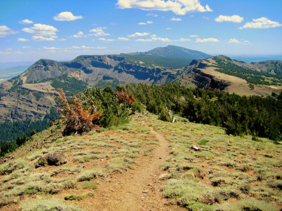
A dirt hiking trail winding across a grassy mountain ridge with a vast volcanic mountain range in the background under a blue sky.
A scenic view along the Summit Trail in the South Warner Wilderness of Modoc National Forest.

Modoc National Forest history and protected-area timeline

Modoc National Forest has its administrative origins in the early federal conservation movement of the twentieth century. It was first established as the Modoc Forest Reserve on November 29, 1904, by the United States General Land Office, during the era when forest reserves were being set aside across the American West to protect watersheds and timber resources from unregulated exploitation. The reserve was named for the Modoc people, the Indigenous inhabitants of the surrounding region whose traditional territory encompassed much of the area the forest now covers.

Following the 1905 transfer of federal forest reserves to the newly created U.S. Forest Service, the area was redesignated as a National Forest on March 4, 1907. In 1908, the separate Warner Mountains National Forest, which covered the eastern ranges now within Modoc's boundary, was consolidated into Modoc National Forest, creating the larger unified landscape that exists today. The South Warner Wilderness, one of the designated Wilderness Areas within the forest, represents a more recent layer of protection focused specifically on preserving the roadless character and ecological value of the Warner Mountains.

Modoc National Forest landscape and geographic character

The landscape of Modoc National Forest is defined by its layered volcanic history and its sharp contrast between arid lowlands and forested mountains. Geologically, much of the forest sits on immense lava flows that spread across the region over roughly half a million years, producing a terrain of rocky soils, undulating plateaus, and broad basins that drain sluggishly into internal lake systems and seasonal wetlands. This volcanic substrate gives the forest a distinctive feel compared to the more granitic landscapes elsewhere in the Sierra Nevada region.

The dominant topographic feature is the Warner Mountains in the eastern portion of the forest. These mountains rise abruptly from the surrounding plateau, with particularly steep eastern escarpments and a more gradual ascent from the western side. The result is a dramatic transition across short distances, from sagebrush flats and lava-strewn basins into pine-covered ridges and subalpine forest.

On the forest's western side, the terrain transitions into brushy foothills sprawling across Modoc, Lassen, and Siskiyou counties. These foothills are dissected by creeks and seasonal drainages, giving them a rolling, semi-arid character punctuated by rocky uplands. Throughout the forest, the interplay of elevation, slope, and volcanic soils produces a fragmented mosaic of plant communities and scenic contrasts that define the overall landscape identity of the region.

Modoc National Forest ecosystems, habitats, and plant life

Modoc National Forest spans an unusually broad ecological spectrum for a single national forest unit, owing to the combination of arid plateaus, deep volcanic soils, and a substantial elevation range. At the lower elevations, the vegetation is open and shrubby, dominated by bitterbrush and curl-leaf mahogany, two hardy woody plants well adapted to the dry, rocky conditions of the Modoc Plateau.

As elevation increases, these shrublands give way to increasingly dense conifer forests. Mid-elevations are characterized by ponderosa pine, white fir, red fir, incense cedar, and occasional stands of aspen, creating a classic mixed conifer belt that provides both habitat complexity and significant timber value. Higher still, lodgepole pine and western white pine come to dominate the slopes approaching the Warner Mountains' summits, often occurring in open, park-like stands typical of harsh subalpine environments.

A particular ecological feature of the forest is its old-growth component. Approximately 43,400 acres have been formally identified as old growth, composed largely of lodgepole pine, ponderosa pine, white fir, incense cedar, and red fir. The forest's elevation and precipitation gradient supports a large number of plant species, and the combination of steppe, woodland, and high-elevation forest communities gives it a uniquely layered vegetation profile within the California National Forest System.

Modoc National Forest wildlife and species highlights

The mosaic of habitats across Modoc National Forest supports a diverse community of wildlife typical of the Great Basin and montane transition zones of the American West. The sagebrush-and-bitterbrush foothill country provides habitat for species associated with high desert and shrub-steppe ecosystems, while the forested Warner Mountains support animal communities more typical of coniferous mountain ranges.

Mule deer and pronghorn are among the most characteristic large mammals of the region, moving seasonally between summer range in the higher elevations of the Warner Mountains and winter range on the broader plateaus. Predators and scavengers found in the forest include coyotes, mountain lions, and various raptors, while the remote basins and wetlands scattered across the volcanic terrain provide habitat for waterfowl and shorebirds during seasonal migrations.

The forest's old-growth stands, particularly those composed of large pines and firs, are ecologically important for cavity-nesting birds and a variety of small mammals, as well as for the structural diversity they add to the overall forest environment. This mix of open shrublands, mixed conifer forests, and high-country habitats gives Modoc National Forest a rich and regionally significant wildlife character, even though the area is sparsely populated and lightly visited compared to many other national forests in California.

Modoc National Forest conservation status and protection priorities

Modoc National Forest plays a meaningful role in conserving the ecological character of northeastern California, a region shaped heavily by volcanic processes and dominated by sagebrush steppe and montane forest ecosystems that are increasingly important for landscape-scale conservation. The forest's vast acreage and relatively low level of fragmentation across much of its territory make it a key stronghold for plant and animal communities adapted to the Modoc Plateau.

A significant conservation designation within the forest is the South Warner Wilderness, which protects a roadless portion of the Warner Mountains and preserves the area's natural ecological processes, watersheds, and habitat for wildlife dependent on undisturbed mountain terrain. Old-growth tracts identified within the forest, totaling tens of thousands of acres, further support conservation goals by maintaining structural forest characteristics that are increasingly rare in managed landscapes.

The forest's elevation and precipitation gradient, combined with its diverse substrate, also gives it disproportionately high botanical value for a region of its size. By encompassing steppe, montane, and subalpine communities within a single administrative unit, Modoc National Forest helps maintain ecological connectivity and biodiversity in a part of California where large, intact natural landscapes are still possible.

Modoc National Forest cultural meaning and human context

The cultural identity of Modoc National Forest is closely tied to the history of the Modoc people, the Indigenous inhabitants of the surrounding region. The forest's name reflects the Modoc's longstanding presence in the area, and the broader landscape of northeastern California carries the imprint of their traditional land use, seasonal movement, and ecological knowledge.

The early twentieth-century establishment of the Modoc Forest Reserve, and its later consolidation with the Warner Mountains National Forest in 1908, occurred during a formative period for federal forest policy in the United States. These administrative actions mark the region's transition into a multi-use landscape managed under federal conservation goals, while also framing how the broader public came to perceive and access this remote part of California. Today, the forest remains anchored by small rural communities such as Alturas, Adin, Cedarville, and Tulelake, which continue to shape its working landscape character.

Top sights and standout views in Modoc National Forest

Modoc National Forest stands out for sheer size, encompassing over 1.6 million acres of northeastern California terrain that is otherwise lightly populated and minimally developed. Its landscape is unusual in being built on extensive ancient lava flows, giving the forest its distinctive basalt soils, rolling plateaus, and rugged drainage patterns.

Among its most notable features are the Warner Mountains, which rise dramatically from the surrounding steppe and contain the South Warner Wilderness, and the forest's substantial old-growth acreage composed of pine, fir, and cedar stands. Together with its range of plant communities, from bitterbrush shrublands to high-elevation lodgepole pine, the forest offers one of the most ecologically layered experiences of any national forest in California.

Best time to visit Modoc National Forest

Modoc National Forest's remote interior character means that seasonal conditions strongly influence the experience of visiting. Summer and early fall are generally the most accessible periods, when roads and trails in the Warner Mountains are typically free of snow and the high-country forests are at their most inviting for hiking, camping, and scenic driving through mixed conifer stands.

Spring and early summer can also be rewarding, particularly in the lower sagebrush and foothill areas, when wildflower displays and cooler temperatures make wildlife viewing and birdwatching productive. Winter brings heavy snow to the higher elevations, especially in the Warner Mountains, transforming the forest into a quieter, snow-covered landscape, though access to higher elevations becomes more limited. Visitors drawn to the forest's volcanic plateaus should generally plan around the warm, dry months when the region's many broad vistas and remote byways are most easily enjoyed.

Monthly climate preview

Long term representative temperature and precipitation records by month

Modoc National Forest Climate Normals and Annual Weather Patterns

Representative coordinate records show measured annual shifts in temperature and monthly precipitation across Modoc National Forest from 1991 to 2020. Examining the complete twelve month profile provides deeper insight into long term climate normals and seasonal weather variations.
Annual mean9 °C
-1 °C21 °C
Jan-1°
Feb
Mar
Apr
May11°
Jun16°
Jul21°
Aug20°
Sep16°
Oct
Nov
Dec-1°
Warmest month
July

20.9 °C

Coolest month
December

-1.3 °C

Wettest month
December

4.1 mm/day

Driest month
August

0.2 mm/day

Park location guide

Geography guide, regional context, and park location map for Modoc National Forest

Modoc National Forest park geography, regions, and map view in United States of America

Understand where Modoc National Forest sits in United States of America through a broader geographic reading of the surrounding landscape, nearby location context, and its mapped position within the national park landscape.

How Modoc National Forest fits into United States of America

The United States of America is a federal presidential republic and one of the world's largest countries by area and population. It consists of 50 states across a vast territory spanning multiple time zones, with its capital in Washington, D.C. and largest city in New York City. The nation has a diverse economy, influential political system, and significant cultural and military presence globally.

Wider geography shaping Modoc National Forest in United States of America

The United States occupies a vast territory in North America, bordered by Canada to the north and Mexico to the south. The 48 contiguous states stretch from the Atlantic to the Pacific Ocean, while Alaska occupies the northwestern region and Hawaii is an archipelago in the Pacific. The country encompasses diverse terrain including the Rocky Mountains, Appalachian Mountains, Great Plains, and extensive river systems.

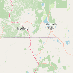
Map view of Modoc National Forest

Use this park location map to pinpoint Modoc National Forest in United States of America, understand its exact geographic position, and read its mapped placement within the surrounding landscape more clearly.

Pigeon | © OpenStreetMap contributors

Location context for Modoc National Forest

California
Recorded earthquake history

Explore the Historical Earthquake Catalogue for Modoc National Forest

Examine the record of past seismic activity associated with the geography of Modoc National Forest. This catalogue, powered by data from MoriAtlas, allows for the review of historical event metrics and epicentre distances within the region.

Modoc National Forest Earthquake History

Catalogued events

530 events

Strongest magnitude

Magnitude 5

Most recent event

May 26, 2026

This history includes earthquakes recorded inside the park or within 50 km of its borders

Visualizing volcanic plateaus, sagebrush steppe, and mountain forests

Modoc National Forest Landscape and Scenery Photography

Modoc National Forest photos reveal vast high desert basins, ancient lava flows, and the rugged crest of the Warner Mountains. Examining protected area imagery clarifies the dramatic ecological transitions shaping this remote California wilderness.

A dirt hiking trail winding across a grassy mountain ridge with a vast volcanic mountain range in the background under a blue sky.

Park atlas

Compare regional volcanic terrains, mountain ranges, and connected conservation areas.

Explore Parks Near Modoc National Forest and Surrounding Protected Landscapes

Browsing other protected areas near Modoc National Forest reveals the complex volcanic geography and high desert transitions defining northeastern California. Expanding the regional comparison helps trace connected conservation landscapes and adjacent public lands across neighboring basins.
A wide watercolor illustration showing a calm body of water surrounded by green hills, conifer trees, and reeds in the foreground.
Protected landscapeCalifornia
Park boundaries overlap#1 closest

South

Lassen National Forest: Mapped Geography and Protected Landscapes of Northern California

Volcanic terrain and expansive old growth ecosystems

Lassen National Forest represents a vast protected landscape in Northern California, defined by its severe volcanic geology and resilient conifer forests. This atlas entry provides essential geographic context regarding the forest boundaries, the volcanic rim of Mount Tehama, and the intricate river systems shaping the region. Explore the terrain, from accessible lava tubes to the wilderness areas preserved within this significant mountain corridor.

Area
4,331.53 km²
Established
1905
Relief
Mountain
Climate
Temperate
A soft watercolor painting depicting a serene landscape with gentle green hills, a small forest, and a calm lake at sunrise or sunset.
Protected landscapeCalifornia
Park boundaries overlap#2 closest

Southwest

Shasta, Trinity National Forest: Mapping the Protected Landscapes of Northern California

Volcanic peaks, expansive reservoirs, and rugged mountain wilderness

Spanning over two million acres, Shasta, Trinity National Forest represents a major protected landscape in Northern California. The geography includes the iconic Mount Shasta volcano and the complex shoreline of Shasta Lake, while hosting expansive wilderness areas and diverse terrain ranging from oak-forested foothills to alpine meadows.

Area
8,942.87 km²
Established
1954
Relief
Mountain
Climate
Temperate
Protected landscapeCalifornia
18 km away#3 closest

Northwest

Butte Valley National Grassland: Geographic Overview and Protected Landscape Mapping

High-desert sagebrush steppe in Northern California

Butte Valley National Grassland is a singular protected landscape in northern California, known for its expansive sagebrush steppe and dry lakebed terrain. Centered in the Klamath River basin, the grassland provides an essential high-desert habitat framed by the dramatic volcanic presence of the Cascade Range and Mount Shasta. This atlas entry details the geography, soil composition, and mountain-framed boundaries of this unique protected area.

Area
74.56 km²
Established
1991
Relief
Upland
Climate
Temperate
National parkCalifornia
39 km away#4 closest

South

Lassen Volcanic National Park: Protected Landscape Identity and Geographic Context

Discover the mapped boundaries and natural terrain of this California national park.

Gain a structured understanding of Lassen Volcanic National Park as a protected landscape. This detail page provides essential geographic context, focusing on the park's mapped boundaries and its specific terrain characteristics within California. It is designed for users seeking detailed information about the park's protected status and its placement within the broader atlas of natural areas, emphasizing its unique geographic identity and conservation significance.

Area
430.8 km²
Established
1916
IUCN
II
Visitors
504.8K annual
A soft watercolor illustration depicting a series of distant mountain ranges behind a line of evergreen trees against a white background.
Wildlife reserveCalifornia
41 km away#5 closest

West

Mount Shasta Wilderness: A Geographic Profile of California Volcanic and Alpine Landscapes

Mapping protected volcanic peaks and glacial ecosystems

Deeply explore the protected geography of Mount Shasta Wilderness, a 38,200-acre reserve in Northern California. This record details the park's stratovolcano foundations, glacial terrain, and forested corridors, offering a clear view of the complex landforms and boundary systems that define this significant high-elevation protected area.

Area
155 km²
Established
1984
IUCN
Ib
Relief
Mountain
Protected areaNevada
50 km away#6 closest

East

Little High Rock Canyon Wilderness: Mapping the High Desert Protected Landscapes of Nevada

A rugged canyon environment within the expansive Great Basin desert

Explore the distinct geography of Little High Rock Canyon Wilderness, where sharp basalt walls and sheltered canyons break the wide sagebrush expanse of northern Nevada. This protected area serves as a vital component of the High Rock country, offering a compact yet significant look at the high desert terrain and historic landscape features defining this remote portion of the Great Basin.

Established
2000
Relief
Upland
Climate
Arid
Access
Remote access
Wildlife reserveOregon
52 km away#7 closest

North

Gearhart Mountain Wilderness: Protected Mountain Geography and Forest Atlas

High elevation terrain in the Fremont Winema National Forest

Spanning the border between Lake and Klamath counties, Gearhart Mountain Wilderness stands as a testament to the diverse mountain geography of south-central Oregon. The area features a complex mosaic of white fir, ponderosa pine, and pure lodgepole stands, set within a glacially sculpted landscape of cirques and ridges. This protected refuge serves as a key headwater source and mountain sanctuary, offering expansive vistas that span from the southern Cascades to the far horizon of the Oregon desert landscape.

Area
92.36 km²
Established
1943
IUCN
Ib
Relief
Mountain
Wildlife reserveOregon
55 km away#8 closest

Northwest

Mountain Lakes Wilderness: Geographic Atlas of Oregon's Glacial Volcanic Reserve

Mapping the volcanic cirques and square boundaries of the southern Cascades.

Mountain Lakes Wilderness serves as a primary geographic anchor in the southern Cascades, where shield volcanoes meet glacially carved basins. This protected area contains over twenty lakes situated in high-altitude cirques near the summits of volcanic peaks like Aspen Butte. The area is defined by its distinctive square survey-township boundary, providing a clear footprint of wilderness conservation within the larger Fremont-Winema National Forest terrain.

Area
93 km²
Established
1964
IUCN
Ib
Relief
Mountain

Common questions about visiting, size, designation, and location context for Modoc National Forest

Modoc National Forest FAQs for park facts, access, geography, and protected area context

Find quick answers about Modoc National Forest, including protected-area facts, park geography, trail and visitor context, and how the park fits into its surrounding country and regional landscape.
MoriAtlas Explorer

Continue Your Protected Areas Search Across the Global Atlas

Deepen your exploration by continuing the structured search for national parks and protected areas worldwide. Utilize the comprehensive filtering capabilities to compare different conservation landscapes and refine your understanding of global park geography. Discover more about the distribution and characteristics of protected natural areas.

Global natural geography