Mori Atlas logo
Natural monumentMonumento natural municipal Muela del Diablo

Geographic boundaries and terrain analysis of the Muela del Diablo hill and Cuevo River basin.

Monumento natural municipal Muela del Diablo: A Mapped Study of Protected Natural Landscapes

Monumento natural municipal Muela del Diablo represents a critical protected area within the Santa Cruz department of Bolivia, encompassing elevated serranías that rise significantly above the surrounding Gran Chaco plain. This atlas entry examines the physical terrain of the peak, its role in aquifer recharge for the Cuevo River basin, and its position within the broader regional topography.

Gran Chacodry forestserraníashilltop lookoutaquifer rechargewatershed protection

Monumento natural municipal Muela del Diablo

Natural monument

Park overview

Structured park overview, official facts, and landscape profile for Muela del Diablo Municipal Natural Monument

Muela del Diablo Municipal Natural Monument park facts, protected area profile, and essential visitor context

Review the core facts for Muela del Diablo Municipal Natural Monument, including designation, size, terrain, visitor scale, habitats, and operating context in one park-focused overview.

About Muela del Diablo Municipal Natural Monument

Muela del Diablo Municipal Natural Monument stands as one of the smaller yet distinctive protected areas of southeastern Bolivia. It lies within the municipality of Boyuibe, in the Cordillera province of Santa Cruz, where the terrain transitions from the low Chaco plains into a chain of low mountains and serranías. The Gran Chaco ecoregion shapes both its climate and its vegetation, lending the area a dry, rugged character that contrasts with the more humid parts of lowland Bolivia.

Created in 2009 under municipal ordinance, the protected area was conceived not only to safeguard scenery but also to protect a vital hydrological system. The hills of Muela del Diablo capture rainfall and channel it into aquifer systems that sustain the headwaters of the Cuevo River. In a region where water is precious, this role gives the monument a conservation value far beyond what its modest size might suggest.

At the same time, the area has been identified as a priority for ecotourism development. The elevation of the Muela del Diablo peak, around 1,148 meters, provides a commanding view over the surrounding Chaco landscape, where the plains open out between the Aguaragüe range and the Mandeyapecuá serranía. The mix of natural and historical significance, combined with accessible viewpoints, makes the monument a meaningful site for landscape-oriented visitors interested in the less-traveled parts of Bolivia.

Administration is shared between the Municipal Government of Boyuibe, which holds primary responsibility, and the Protected Areas Directorate of the departmental government of Santa Cruz, which provides support. This municipal level of protection reflects both the local ecological importance and the strong connection between the monument and the surrounding community.

Quick facts and research context for Muela del Diablo Municipal Natural Monument

Muela del Diablo Municipal Natural Monument is located in the municipality of Boyuibe, in the Cordillera province of the Santa Cruz department, in southeastern Bolivia. It belongs to the Gran Chaco ecoregion and protects a landscape of serranías and hills along the edge of the Aguaragüe range.

The protected area was established on April 9, 2009, through Municipal Ordinance No. 06/2009 of the Government of Boyuibe, and covers approximately 5,099 hectares. Administration is municipal, supported by the Protected Areas Directorate of the Santa Cruz departmental government.

Protection and recognition

Examine the terrestrial protection scope and documented designation records for this protected landscape.

Monumento Natural Municipal Muela del Diablo Protection Status and Recognition

Monumento natural municipal Muela del Diablo maintains a documented terrestrial protection scope within the global conservation registry. Review the verified designation metrics, management context, and associated recognition records for this protected area.

Protection details

Protection scope
Terrestrial
Transboundary protection
No
Park context

Deeper park guide and search-rich context for Muela del Diablo Municipal Natural Monument

Muela del Diablo Municipal Natural Monument history, landscape, wildlife, and travel context

Explore Muela del Diablo Municipal Natural Monument through its history, landscape character, ecosystems, wildlife, conservation priorities, cultural context, and seasonal travel timing in a structured park guide built for atlas discovery and search intent.

Why Muela del Diablo Municipal Natural Monument stands out

The monument is best known for the Muela del Diablo peak, a prominent hilltop that rises above the Chaco plain and serves as a sweeping natural lookout. From this elevation, visitors can see the vast Chaco lowland stretching out from the foothills of the Aguaragüe range toward the distant Mandeyapecuá serranía. Equally important is the area's hydrological role: the hills protect a system of springs and recharge zones that feed the Cuevo River basin, making the monument a critical refuge for water resources in an otherwise dry Chaco landscape. Together, the scenic viewpoints and aquifer function define the park's identity.

Muela del Diablo Municipal Natural Monument history and protected-area timeline

The Muela del Diablo Municipal Natural Monument has a relatively short formal history as a protected area: it was established on April 9, 2009, through Municipal Ordinance No. 06/2009 issued by the municipality of Boyuibe. The ordinance formalized municipal-level protection for the surrounding serranías and hills, recognizing their scenic, ecological, and hydrological value.

Before that designation, the site already carried significant historical meaning. The heights of Muela del Diablo are remembered as a strategic location during the Chaco War between Bolivia and Paraguay. From this elevated position, the Bolivian army began the retaking of Boyuibe and pushed back the Paraguayan forces. The peak's commanding views of the surrounding terrain, today appreciated for their beauty, were once valued for their military vantage point.

The combination of wartime memory and modern conservation gave local authorities a clear rationale to formalize protection of the area, linking natural heritage with regional identity.

Muela del Diablo Municipal Natural Monument landscape and geographic character

The landscape of the monument is defined by a transition between Chaco lowlands and elevated serranías. The defining feature is the Muela del Diablo peak itself, which rises to roughly 1,148 meters above sea level and dominates the surrounding terrain. The hill's profile, with its distinctive shape, gives the protected area much of its visual identity.

From these elevations, the view opens out over a vast expanse of Chaco plain, framed by the foothills of the Aguaragüe range to one side and extending toward the Mandeyapecuá serranía in the distance. The combination of rugged, rocky slopes above and open lowlands below creates a layered landscape that feels larger than the protected area's formal footprint.

The drainage patterns of these hills are an essential part of the physical setting. Runoff and infiltration feed the aquifer system that sustains the upper Cuevo River basin, making the topography not just scenic but functionally central to water availability in the region.

Muela del Diablo Municipal Natural Monument ecosystems, habitats, and plant life

Ecologically, the monument sits firmly within the Gran Chaco ecoregion, one of South America's great dry forest systems. The vegetation reflects this setting, with hardier plant communities adapted to long dry seasons, high temperatures, and seasonal rains. The hills and serranías support a slightly different ecological profile than the surrounding plains, often retaining moisture longer and offering varied microhabitats.

The protected area's most significant ecological function lies underground. The hill systems capture and store seasonal rainfall, replenishing aquifers that spring from the foothills and feed the Cuevo River. This recharge role is critical in a region where surface water can be scarce, and it underpins broader ecosystem health across the watershed.

While the monument does not have the broad biological fame of larger parks, the mosaic of rocky slopes, scrub, and dry forest contributes to habitat continuity within the Chaco, supporting the ecological resilience of the broader landscape.

Muela del Diablo Municipal Natural Monument wildlife and species highlights

The fauna of the Muela del Diablo area reflects the broader Gran Chaco ecosystem, where wildlife has adapted to a hot, dry, and often challenging environment. The mosaic of serranías and lowlands provides a variety of habitats for small and medium-sized mammals, reptiles, and birds typical of the Chaco.

Birdlife is among the more visible elements of the park's wildlife, with species adapted to dry forest and open terrain expected throughout the area. The hills can also serve as reference points and shelter for larger Chaco species moving across the landscape.

While the monument is not primarily recognized as a wildlife destination, its protected status helps maintain habitat connectivity in a region that has historically faced significant land-use pressure. The conservation of these landscapes supports the broader survival of Chaco wildlife well beyond the monument's boundaries.

Muela del Diablo Municipal Natural Monument conservation status and protection priorities

The monument's conservation value rests on a combination of hydrological protection and landscape preservation. Its watershed role, feeding the Cuevo River through aquifer recharge, is perhaps its most critical environmental function, particularly in a region where freshwater availability is a defining concern for both people and ecosystems.

By protecting serranías and headwater zones, the area also helps maintain habitat for Chaco species and supports ecological processes across the broader dry forest region. The local recognition of the site as a priority for ecotourism reflects an awareness that conservation and sustainable use can reinforce each other in this landscape.

Municipal-level protection links conservation directly to the Government of Boyuibe and the local community, embedding stewardship into the regional governance structure. This local anchor is central to the area's long-term protection, supplementing departmental and national oversight from the Santa Cruz Protected Areas Directorate.

Muela del Diablo Municipal Natural Monument cultural meaning and human context

The monument carries strong cultural resonance for the municipality of Boyuibe and surrounding communities. Its peak is remembered as a military landmark from the Chaco War, when Bolivian forces used the elevation to launch a counter-offensive and reclaim the town. This wartime memory gives the landscape an enduring place in regional identity.

In addition to its historical memory, the area is woven into local perceptions of natural heritage. The prominence of the peak, its visibility from the surrounding plains, and its role as a source of water have long made Muela del Diablo a meaningful landmark for residents, even before its formal designation as a protected area.

Top sights and standout views in Muela del Diablo Municipal Natural Monument

The protected area's strongest highlights are clustered around the Muela del Diablo peak: its elevation, its sweeping lookout over the Chaco plain, and the layered views from the Aguaragüe foothills to the Mandeyapecuá serranía. This combination of dramatic scenery and broad horizons is the monument's signature feature.

Equally compelling is the area's hydrological importance, with its role in recharging the aquifers that feed the Cuevo River basin. The site also stands out for its layered history, linking the Chaco War's military legacy to a contemporary conservation and ecotourism narrative.

Best time to visit Muela del Diablo Municipal Natural Monument

The monument's climate follows the rhythm of the Gran Chaco, with a marked dry season and a wetter period concentrated in the warmer months. Visiting during the cooler, drier months generally offers clearer skies, more comfortable temperatures for hiking, and better visibility from the Muela del Diablo lookout, which is the park's main scenic attraction.

The wetter season can transform the landscape with greener vegetation and more active surface water, though it may also bring higher temperatures and more challenging trail conditions. For visitors primarily interested in panoramic vistas and comfortable hiking, the dry season tends to be preferable; for those drawn to greener Chaco scenery, the transition into the rainy months can be rewarding.
Monthly climate preview

Long-term temperature ranges and monthly precipitation distributions recorded at representative coordinates

Monumento natural municipal Muela del Diablo Climate Normals and Annual Weather Patterns

Monumento natural municipal Muela del Diablo exhibits a measured annual temperature rhythm alongside distinct seasonal precipitation variations derived from historical NASA POWER data. Reviewing the complete twelve-month climatological profile provides deeper analytical insight into representative temperature extremes and monthly moisture patterns.
Annual mean23 °C
18 °C26 °C
Jan26°
Feb25°
Mar24°
Apr22°
May20°
Jun19°
Jul18°
Aug21°
Sep24°
Oct26°
Nov26°
Dec26°
Warmest month
November

26.2 °C

Coolest month
July

18.2 °C

Wettest month
February

5.2 mm/day

Driest month
July

0.5 mm/day

Park location guide

Geography guide, regional context, and park location map for Muela del Diablo Municipal Natural Monument

Muela del Diablo Municipal Natural Monument park geography, regions, and map view in Bolivia

Understand where Muela del Diablo Municipal Natural Monument sits in Bolivia through a broader geographic reading of the surrounding landscape, nearby location context, and its mapped position within the national park landscape.

How Muela del Diablo Municipal Natural Monument fits into Bolivia

Bolivia, officially the Plurinational State of Bolivia, is a landlocked country in central South America. It features diverse geography including the Andean mountain range, Amazonian plains, Gran Chaco, and the Pantanal wetland. The country has a population of approximately 11.4 million and is administratively divided into nine departments, with La Paz as the seat of government and Sucre as the constitutional capital.

Wider geography shaping Muela del Diablo Municipal Natural Monument in Bolivia

Bolivia is located in central South America, bordered by Brazil to the north and east, Paraguay to the southeast, Argentina to the south, Chile to the southwest, and Peru to the west. The country is divided between a western Andean region and tropical lowlands to the east and north. It includes the Amazonian plain, Gran Chaco, temperate valleys, the high-altitude Altiplano plateau, and part of the Pantanal wetland along its eastern border.

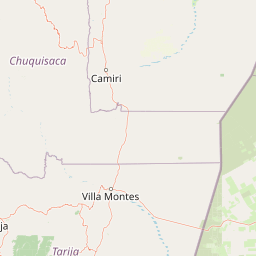
Map view of Muela del Diablo Municipal Natural Monument

Use this park location map to pinpoint Muela del Diablo Municipal Natural Monument in Bolivia, understand its exact geographic position, and read its mapped placement within the surrounding landscape more clearly.

Pigeon | © OpenStreetMap contributors

Location context for Muela del Diablo Municipal Natural Monument

Santa Cruz
Park atlas

Compare surrounding Gran Chaco landscapes and regional conservation geography

Other Protected Areas and Parks Near Monumento natural municipal Muela del Diablo

Browse nearby protected areas and neighboring conservation lands connected to the rugged topography around Monumento natural municipal Muela del Diablo. Extending your geographic comparison across the surrounding region reveals broader patterns in dry forest terrain and watershed protection.
National parkChuquisaca Department
About 123 km away#1 closest

Northwest

Iñao National Park and Integrated Management Natural Area: Bolivia National Park and Protected Landscape

Explore the Serranía del Iñao's geography and conservation role.

Iñao National Park and Integrated Management Natural Area is a protected territory located within Chuquisaca Department, Bolivia, centered on the prominent Serranía del Iñao mountain range. This page offers detailed geographic context and an atlas perspective on the park's landscape, its role as a national park, and its contribution to regional conservation efforts in the Andean foothills.

Area
2,630.9 km²
Established
2004
IUCN
II
Scope
Terrestrial
Protected areaGran Chaco Province
About 125 km away#2 closest

South

Aguaragüe National Park and Integrated Management Natural Area: Bolivia's Easternmost Sub-Andean Protected Landscape

Explore its mapped mountain geography and ecological diversity.

Aguaragüe National Park and Integrated Management Natural Area is a crucial protected area in Bolivia's Gran Chaco Province, defined by the Serranía del Aguaragüe mountain range. This landscape offers a unique opportunity to explore a geographic transition zone where Southern Andean Yungas montane forests converge with Dry Chaco ecosystems. The park's protected boundaries encompass a rugged mountain backbone rising from the lowlands, representing a vital segment of Bolivia's Sub-Andean geography and protected natural areas.

Area
1,083.07 km²
Established
2000
IUCN
II
Relief
Mountain
Nature reserveDepartamento de Tarija
About 164 km away#3 closest

Southeast

Reserva natural El Corbalán: Gran Chaco Protected Landscape and Regional Geography

A private nature reserve in Tarija Department, Bolivia.

Spanning the dry plains of the Chaco Boreal, Reserva natural El Corbalán provides essential protection for a representative sample of South American dry forest. The terrain, characterized by sparse thorny woodlands and flat lowland scrub, serves as a crucial habitat refuge. This resource offers insights into the unique ecological structure and mapped boundaries of one of Bolivia's most significant private conservation initiatives.

Area
47.78 km²
Established
1996
Relief
Lowland
Water
Minor water
A soft watercolor illustration of a river flowing through a lush landscape with gentle green hills in the distance.
Wildlife reserveTarija
About 204 km away#4 closest

Southwest

Reserva nacional de flora y fauna de Tariquía: Atlas and Geographic Protected Area Overview

Montane cloud forest and subandean river valleys in Tarija

This wildlife reserve preserves the most intact stands of Yungas Tucumano-Boliviano forest in Bolivia. Featuring a dramatic vertical zonation from foothill selva to high-elevation pine woodlands, the area serves as a primary hub for ecological research and conservation in the rugged landscapes of Tarija near the Argentine border.

Area
2,468.7 km²
Established
1989
Relief
Mountain
Climate
Subtropical
A watercolor painting of a simplified, abstract landscape with rolling hills in shades of green, yellow, and muted pink against a white background.
Protected landscapeTarija
About 205 km away#5 closest

Southwest

Parque natural y área de manejo integrado El Cardón: Geography and Protected Area Atlas

High-altitude puna landscapes and cactus diversity in Tarija, Bolivia.

Spanning the high-altitude plateaus of southern Bolivia, this protected area features a unique mosaic of arid terrain, specialized cactus ecosystems, and vital wildlife corridors. The landscape provides a deep look into the puna and pre-puna geography of the Tarija department, including significant archaeological sites and thriving populations of wild vicuñas within a dramatic, high-elevation Andean environment.

Area
300.56 km²
Established
2003
Relief
Mountain
Climate
Arid
Watercolor illustration showing a pale green rural landscape with rolling hills, scattered trees, a winding path or stream, and small buildings in the distance
Biosphere reserveBolivia
About 211 km away#6 closest

Southwest

Reserva Biológica de la Cordillera de Sama: Protected Mountain Landscapes of Southern Bolivia

High-Andean biosphere reserve featuring lagoons, dunes, and ancient pathways.

Reserva Biológica de la Cordillera de Sama encompasses a vast elevation range from dry inter-Andean valleys to the 4,700-meter peaks of the Cordillera Oriental. This reserve protects the endorheic Tajzara basin, where seasonal lagoons and sand dunes contrast with relict forests and steep mountain ravines. Its geography offers a complex mosaic of ecosystems, providing essential water sources and specialized habitat for endemic fauna within the southern Bolivian highlands.

Area
1,085 km²
Established
1991
Relief
Mountain
Climate
Alpine
Wildlife reserveTarija Department
About 231 km away#7 closest

Southwest

Tajzara Wildlife Reserve: Geographic and Landscape Overview of the Tarija Basin

High-altitude wetlands and saline lagoons in the Bolivian Andes

Tajzara Wildlife Reserve stands as a critical high-altitude wetland complex within the Tarija Department. This protected landscape sustains life across saline lake beds, seasonal pools, and marshy margins, functioning as a vital refuge for migratory waders and flamingo populations in the harsh, arid climate of the Bolivian Altiplano.

Area
13 km²
Established
1999
Relief
Highland
Climate
Alpine
National parkSanta Cruz Department
About 254 km away#8 closest

North

Amboró National Park: Its Protected Area Identity and Geographic Context

Mapped boundaries and regional landscape details.

Amboró National Park is a designated national park situated within the Santa Cruz Department, Bolivia. This entry provides detailed insights into its protected landscape, focusing on its geographical significance and mapped boundaries. Users can explore how Amboró National Park fits into the broader regional geography, enhancing their understanding of conservation areas and mapped natural terrains for atlas-based research and discovery. Its specific location and protected status are crucial for understanding its ecological and geographic role.

Area
4,425 km²
Established
1984
IUCN
II
Relief
Mountain

Common questions about visiting, size, designation, and location context for Muela del Diablo Municipal Natural Monument

Muela del Diablo Municipal Natural Monument FAQs for park facts, access, geography, and protected area context

Find quick answers about Muela del Diablo Municipal Natural Monument, including protected-area facts, park geography, trail and visitor context, and how the park fits into its surrounding country and regional landscape.
MoriAtlas Explorer

Continue Your Protected Areas Search Across the Global Atlas

Deepen your exploration by continuing the structured search for national parks and protected areas worldwide. Utilize the comprehensive filtering capabilities to compare different conservation landscapes and refine your understanding of global park geography. Discover more about the distribution and characteristics of protected natural areas.

Global natural geography