

Mori Atlas logo
Protected landscapeMorar, Moidart and Ardnamurchan National Scenic Area

Mapping the diverse coastal terrain, sea lochs, and rugged peninsulas of western Scotland

Morar, Moidart and Ardnamurchan National Scenic Area: A Remote Protected Highland Landscape

The Morar, Moidart and Ardnamurchan National Scenic Area encompasses one of the most varied coastal stretches in the western Highlands. This protected landscape is defined by its dramatic contrast between exposed Atlantic headlands, sheltered sea lochs, and the distant vistas of the Small Isles. By examining the mapped boundaries and terrain, users can understand the ecological and cultural significance of this remote region, which remains largely untouched by major roads and retains its original wilderness character.

national scenic areaHighland coastwestern Highlandspeninsula landscapecoastal scenerysea lochs

Morar, Moidart and Ardnamurchan National Scenic Area

Protected landscape

Park overview

Structured park overview, official facts, and landscape profile for Morar, Moidart and Ardnamurchan National Scenic Area

Morar, Moidart and Ardnamurchan National Scenic Area park facts, protected area profile, and essential visitor context

Review the core facts for Morar, Moidart and Ardnamurchan National Scenic Area, including designation, size, terrain, visitor scale, habitats, and operating context in one park-focused overview.

About Morar, Moidart and Ardnamurchan National Scenic Area

Morar, Moidart and Ardnamurchan National Scenic Area encompasses a vast sweep of the western Scottish Highland coastline, stretching across three named peninsulas and the waters between them. It represents the kind of deeply indented, island-studded seascape that defines the Atlantic edge of the Highlands, where sea lochs cut deep into mountainous terrain and the open ocean lies only a short distance inland.

Administratively, the area falls within the Highland council area in Scotland and is one of the country's 40 national scenic areas. These designations exist specifically to identify areas of exceptional scenery and to safeguard them from inappropriate development through the planning process. Although the protection is meaningful, the absence of a dedicated national park authority means the area is administered through NatureScot and Highland Council rather than a single management body. Most NSAs in Scotland, including this one, do not have a published management strategy.

The scenic value of the area lies in its juxtaposition of contrasting coastal environments. According to the 1978 review that formed the basis for designation, the coastal landscape is one of great diversity and interest, enhanced in places by a mountainous backdrop. The coastal fringe is composed of four main subsidiary areas, each with its own character yet visually linked by views of the offshore Small Isles. The area's mountainous interior, the Arisaig and Ardnish peninsulas, and large stretches of coastline cannot be reached by road, giving the landscape a notably wild and undisturbed character.

Historically, the region has strong connections to the Jacobite rising of 1745. Loch nan Uamh is the place where Charles Edward Stuart first landed in Scotland, and the famous row of beech trees known as the Seven Men of Moidart commemorates the seven supporters who arrived with him. Castle Tioram, a striking ruined medieval castle overlooking a tidalloch in Moidart, contributes both cultural depth and additional scenic value.

Quick facts and research context for Morar, Moidart and Ardnamurchan National Scenic Area

Morar, Moidart and Ardnamurchan is one of 40 national scenic areas in Scotland and is administered by NatureScot. The area lies in the Highland council area and covers 369.6 square kilometres in total, of which about 17,220 hectares are land and 19,736 hectares are marine, including waters below low tide.

The scenic area was established in 1981 under the national scenic area designation, replacing an earlier system of national park direction areas. Its boundaries follow the 1978 landscape review recommendations and were later confirmed under new legislation in 2010. The coast and mountainous interior are largely inaccessible by road, with the north coast of Ardnamurchan reachable only by single-track dead-end routes. The area overlaps with multiple Natura 2000 sites, recognised for golden eagles, freshwater pearl mussels, otters, harbour porpoises and important bog and woodland habitats.

Protection and recognition

Documented protection history and international recognition records

Morar, Moidart and Ardnamurchan National Scenic Area Protection Status

Morar, Moidart and Ardnamurchan National Scenic Area features a mixed protection scope established in 2010. Official records detail the designated status and administrative framework governing the protected landscape.

Protection details

Protection scope
Mixed
Designated year
2010
Transboundary protection
No
Park context

Deeper park guide and search-rich context for Morar, Moidart and Ardnamurchan National Scenic Area

Morar, Moidart and Ardnamurchan National Scenic Area history, landscape, wildlife, and travel context

Explore Morar, Moidart and Ardnamurchan National Scenic Area through its history, landscape character, ecosystems, wildlife, conservation priorities, cultural context, and seasonal travel timing in a structured park guide built for atlas discovery and search intent.

Why Morar, Moidart and Ardnamurchan National Scenic Area stands out

Morar, Moidart and Ardnamurchan is primarily known for its coastal scenery, which is regarded as one of the most outstanding in Scotland. The original designation report highlighted the area's great diversity and interest, describing a coastal fringe made up of distinct subsidiary landscapes linked together by views of the Small Isles offshore. The area is also recognised for its historical association with the Jacobite cause, particularly through Loch nan Uamh, where Charles Edward Stuart first landed in Scotland, and the Seven Men of Moidart beech trees that commemorate his companions. Castle Tioram, a picturesque ruined stronghold in Moidart, adds a further layer of cultural attraction. Ecologically, the scenic area is celebrated for overlapping conservation designations covering breeding golden eagles, freshwater pearl mussels, otters, harbour porpoises and rare bog and woodland habitats.
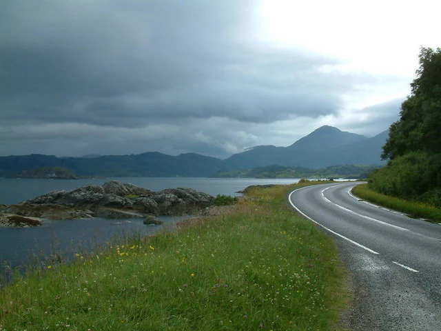
A winding asphalt road curves alongside a rocky shoreline and calm water, with rolling green hills and mountains under a cloudy sky.
A winding coastal road passing through Glenuig Bay, Morar, Moidart and Ardnamurchan National Scenic Area.

Morar, Moidart and Ardnamurchan National Scenic Area history and protected-area timeline

The origins of the national scenic area date to the post-Second World War period, when a committee chaired by Sir Douglas Ramsay was established to consider the preservation of Scotland's landscape. Its 1945 report proposed that five areas; Loch Lomond and the Trossachs, the Cairngorms, Glen Coe-Ben Nevis-Black Mount, Wester Ross, and Glen Strathfarrar-Glen Affric-Glen Cannich, should receive a level of protection. These were designated as national park direction areas, allowing central government to review certain planning decisions made by local authorities.

A further review of landscape protection in 1978 identified additional areas, including the western parts of the Lochaber district, as worthy of protection based on their landscape qualities. Following this review, the national scenic area designation replaced the direction area system in 1981, encompassing the area that became known as Morar, Moidart and Ardnamurchan. The boundaries were drawn in line with the 1978 recommendations and remain the same today.

The national scenic area designation itself was renewed under new legislation in 2010, confirming continued protection of the area's coastal scenery. Despite this, there is no equivalent to a national park authority within the designation, and Highland Council, the relevant local authority, has not produced a current management strategy for the area as it has for some national scenic areas elsewhere in Scotland.

Morar, Moidart and Ardnamurchan National Scenic Area landscape and geographic character

The landscape of Morar, Moidart and Ardnamurchan is defined by its coastal edge, which the original 1978 review described as the area's outstanding element. Four subsidiary coastal landscapes each carry their own character while remaining visually linked by views toward the Small Isles offshore. Together they form one of the most varied stretches of western Highland coast in Scotland.

The terrain combines sea lochs, sheltered bays, exposed headlands and offshore islands, frequently backed by hills and rugged interior uplands. The Arisaig and Ardnish peninsulas, like much of the area's coastline, cannot be reached by public road, and the north coast of Ardnamurchan is accessible only via dead-end single-track roads. This inaccessibility has preserved a sense of remoteness that is increasingly rare elsewhere in the Highlands, allowing the coastal scenery to retain an unbroken, unspoilt appearance.

Familiar landscape features include the silver sands of Morar, the wooded shoreline of Moidart, the dramatic basalt cliffs of Ardnamurchan, the sea lochs such as Loch nan Uamh, and the broad views out toward the Small Isles. The picturesque ruins of Castle Tioram, perched on a tidal island, are an additional and well-known element within this coastal setting.

Morar, Moidart and Ardnamurchan National Scenic Area ecosystems, habitats, and plant life

Ecologically, the scenic area is shaped by the meeting of land and sea. Its habitats range from coastal woodland and machair-influenced shorelines to acidic oak woodland, freshwater burns, bog systems and extensive marine environments. These overlapping ecosystems explain why the protected area also carries several Natura 2000 designations and Special Areas of Conservation.

The Moidart and Ardgour Special Protection Area exists to protect breeding golden eagles, an icon of the western Highlands. Woodland and lochs are protected under the Loch Moidart and Loch Shiel Woods SAC, supporting a population of otters alongside acidic oak woodland. Freshwater pearl mussel colonies occur in the burns of the Ardnamurchan peninsula, preserved under the Ardnamurchan Burns SAC, and owls are linked to Glen Beasdale SAC which contains freshwater pearl mussels, otters and acidic oak woodland.

Coastal ecology is equally important. The Sound of Arisaig contains subtidal sandbanks of recognised European value, while the Inner Hebrides and the Minches SAC supports harbour porpoises in the outer sea area. On land, Kentra Moss offers a rare example of raised bog rich in Sphagnum mosses, and represents an ecological transition zone between bog and saltmarsh that is distinct in the Scottish context.

Morar, Moidart and Ardnamurchan National Scenic Area wildlife and species highlights

The wildlife profile of the national scenic area is anchored by its overlap with multiple conservation designations, giving it an unusually broad faunal interest for an area primarily protected for scenery. The presence of large tracts of largely undisturbed habitat supports a number of species of national and European conservation concern.

Golden eagles are among the most celebrated animals associated with the area, breeding within the Moidart and Ardgour Special Protection Area. Freshwater pearl mussels inhabit the burns of Ardnamurchan, forming some of the most important populations in Scotland. Otters are recorded in the wooded lochs of Moidart and Shiel and in Glen Beasdale, indicating healthy freshwater and coastal ecosystems in these areas.

Marine wildlife is represented by harbour porpoises in the outer sea areas of the NSA, recognised under the Inner Hebrides and the Minches SAC. The blend of coastal, woodland, freshwater and marine habitats produces a varied wildlife context that complements the scenic character of the peninsulas.

Morar, Moidart and Ardnamurchan National Scenic Area conservation status and protection priorities

Conservation significance within the Morar, Moidart and Ardnamurchan NSA extends well beyond its scenic designation. The area hosts a notable concentration of overlapping European and national conservation designations, reflecting its ecological richness as well as its visual appeal. These overlapping layers provide a higher tier of protection for habitats and species of international importance.

Six Special Areas of Conservation sit within or overlap the national scenic area, collectively protecting freshwater pearl mussels, otters, harbour porpoises, subtidal sandbanks, acidic oak woodland and significant bog systems. The Moidart and Ardgour Special Protection Area adds specific protection for breeding golden eagles. Together these designations mean that the area is recognised as both a scenic and an ecological asset of considerable national and European value.

The area also includes contributing features recognised within the Inventory of Gardens and Designed Landscapes in Scotland. Arisaig House, Kinlochmoidart and Eilean Shona all appear in this inventory, linking the cultural heritage of designed landscapes with the broader conservation framework of west Highland Scotland.

Morar, Moidart and Ardnamurchan National Scenic Area cultural meaning and human context

The cultural identity of the area is closely bound up with the Jacobite movement of the 18th century. Loch nan Uamh, within the national scenic area, is the place where Charles Edward Stuart first landed in Scotland during the 1745 rising. Local tradition holds that the site is marked by the Seven Men of Moidart, a row of beech trees said to commemorate the seven supporters who arrived with the prince and who became known by that collective name.

Castle Tioram, a substantial medieval stronghold perched on a tidal island in Moidart, adds a deeper historical layer. Long associated with the Clan MacDonald and later with regional power struggles, its picturesque ruins are widely regarded as one of the most evocative features of the western Highland coastline and contribute both to heritage interpretation and scenic appreciation of the area.

Top sights and standout views in Morar, Moidart and Ardnamurchan National Scenic Area

The national scenic area is defined by the contrast and diversity of its coastal landscapes, with four subsidiary coastal areas linked visually by views of the Small Isles. The remoteness of much of its coastline and interior, largely inaccessible by road, is a defining characteristic that supports both its scenic value and ecological integrity.

Equally significant are the area's overlapping conservation designations. Breeding golden eagles, freshwater pearl mussels, otters, harbour porpoises, blanket bog and acidic oak woodland each receive formal European-level protection within or beside the NSA. Combined with cultural landmarks such as Castle Tioram and the Seven Men of Moidart, the area offers a combination of scenery, wildlife and history that is distinctive within Scotland's system of national scenic areas.

Best time to visit Morar, Moidart and Ardnamurchan National Scenic Area

The western Highlands have a maritime climate that produces relatively mild winters and cool summers, so the area is broadly accessible year-round. Spring and early summer are typically when coastal woodland, wildflowers and birdlife feel most active, while autumn brings strong colour to the broadleaved woodland and quieter conditions for enjoying the coastal scenery. Long summer days and late sunsets over sea lochs are often considered the most atmospheric time to experience the remote western coast, although weather can change quickly at any time of year.
Monthly climate preview

Long-term representative monthly temperature and precipitation data for Highland terrain

Morar, Moidart and Ardnamurchan National Scenic Area Climate Normals and Weather Patterns

Representative coordinate records show measured monthly temperature ranges alongside daily precipitation averages across the protected landscape. Examining the full twelve-month profile provides complete historical climate normals and detailed seasonal metrics.
Annual mean8 °C
3 °C13 °C
Jan
Feb
Mar
Apr
May
Jun11°
Jul13°
Aug13°
Sep11°
Oct
Nov
Dec
Warmest month
July

12.9 °C

Coolest month
February

3.2 °C

Wettest month
January

6.8 mm/day

Driest month
May

3.5 mm/day

Park location guide

Geography guide, regional context, and park location map for Morar, Moidart and Ardnamurchan National Scenic Area

Morar, Moidart and Ardnamurchan National Scenic Area park geography, regions, and map view in United Kingdom

Understand where Morar, Moidart and Ardnamurchan National Scenic Area sits in United Kingdom through a broader geographic reading of the surrounding landscape, nearby location context, and its mapped position within the national park landscape.

How Morar, Moidart and Ardnamurchan National Scenic Area fits into United Kingdom

The United Kingdom is a parliamentary constitutional monarchy located in northwestern Europe, consisting of four constituent countries: England, Scotland, Wales, and Northern Ireland. As a major global power with over 69 million residents, it maintains significant international influence in politics, economics, and culture.

Wider geography shaping Morar, Moidart and Ardnamurchan National Scenic Area in United Kingdom

The United Kingdom is an island nation located in northwestern Europe, surrounded by the Atlantic Ocean, North Sea, English Channel, Celtic Sea, and Irish Sea. It shares a land border with the Republic of Ireland to the west. The territory includes the island of Great Britain, the northeastern portion of Ireland, and most of the smaller British Isles islands.

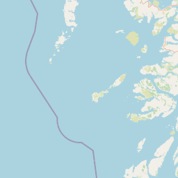
Map view of Morar, Moidart and Ardnamurchan National Scenic Area

Use this park location map to pinpoint Morar, Moidart and Ardnamurchan National Scenic Area in United Kingdom, understand its exact geographic position, and read its mapped placement within the surrounding landscape more clearly.

Pigeon | © OpenStreetMap contributors

Location context for Morar, Moidart and Ardnamurchan National Scenic Area

HighlandScotland

Visualizing the coastal terrain, sea lochs, and remote peninsula landscapes of the Scottish Highlands

Morar, Moidart and Ardnamurchan National Scenic Area Photos and Landscape Scenery

Visual records capture the protected coastal fringe, sea lochs, and rugged headlands that define Morar, Moidart and Ardnamurchan National Scenic Area. Examining these landscape views reveals the remote terrain, habitat diversity, and wild character of this western Highland region.

A winding asphalt road curves alongside a rocky shoreline and calm water, with rolling green hills and mountains under a cloudy sky.

A wide angle view of a sea loch, Loch nan Uamh, surrounded by hills and autumn vegetation under an overcast sky.

Park atlas

Compare surrounding western Highland coastal terrain and adjacent protected areas in Scotland

Parks Near Morar, Moidart and Ardnamurchan National Scenic Area and Regional Protected Landscapes

Browsing other protected areas near Morar, Moidart and Ardnamurchan National Scenic Area reveals connected coastal topography and rugged peninsular terrain. Comparing adjacent regional landscapes provides deeper context for western Highland geography and protected-area distribution.
Marine protected areaLochaber
About 8.9 km away#1 closest

South

Loch Sunart Marine Protected Area: Coastal Geography and Highland Seascape Atlas

Deep-water marine basins and protected Highland coastal terrain.

Discover the mapped landscape of Loch Sunart, a 31-kilometre sea loch in the Lochaber region of Scotland. This marine protected area is characterized by its complex underwater bathymetry, ranging from shallow tidal channels to deep basins reaching 124 metres, providing a unique look into the intersection of terrestrial Highland mountains and essential underwater bivalve and reef communities.

Area
49 km²
Established
2014
IUCN
IV
Relief
Lowland
Marine protected areaArgyll and Bute
About 34 km away#2 closest

Southeast

Loch Creran Marine Protected Area: Atlas and Coastal Geography of Argyll and Bute

Mapped tidal basins, flame shell reefs, and Atlantic oakwood habitats

Loch Creran is a primary example of integrated marine and coastal conservation on the west coast of Scotland. Characterized by its long, narrow form and dramatic bathymetry, the loch creates a rich environment where rapid tidal currents meet sheltered forest shorelines. This record provides a detailed look at the geographic structure, protected seabed zones, and the transition from sea loch to the ancient woodlands at the head of the inlet.

Area
12 km²
Established
2014
IUCN
IV
Relief
Lowland
Watercolor painting of a coastal landscape with distant mountains, a rocky shoreline, and light foreground vegetation on a white background.
Protected landscapeHighland
About 38 km away#3 closest

Northwest

Small Isles Protected Landscape: Atlas of the Highland Inner Hebrides Archipelago

Mapped terrain, volcanic geology, and coastal protected areas.

Delve into the geography of the Small Isles, a protected landscape encompassing Rùm, Eigg, Canna, and Muck. This atlas entry provides a structured look at the volcanic peaks, maritime skerries, and diverse land-stewardship boundaries that define this remote Scottish archipelago.

Area
472.35 km²
Established
1981
Relief
Mountain
Climate
Temperate
Marine protected areaScotland
About 40 km away#4 closest

South

Loch Sunart to the Sound of Jura Marine Protected Area: A Scottish Marine Geography Guide

Charting habitat management and Quaternary seabed geology in the western Highlands.

This protected area reaches across the waters of Loch Sunart, the Sound of Mull, the Firth of Lorne, and the Sound of Jura. By mapping this diverse bathymetry, the area safeguards essential marine habitats and the rare common skate population within a complex network of Highland sounds and coastal basins.

Area
741 km²
Established
2014
IUCN
IV
Climate
Temperate
Marine protected areaHighland
About 55 km away#5 closest

North

Loch Alsh Nature Conservation Marine Protected Area: Geography and Protected Boundaries

A vital Highland marine landscape featuring rare underwater flame shell colonies.

Loch Alsh sits as a distinct marine boundary in the Northwest Highlands of Scotland. This protected area safeguards a vast seafloor ecosystem, most notably a massive flame shell colony that has transformed local understanding of marine biodiversity in the region. The loch landscape blends ancient metamorphic geology with the fjord-like waters separating Skye from the mainland, offering a unique perspective on protected coastal terrains.

Area
0.75 km²
Established
2014
Relief
Mountain
Climate
Temperate
Protected landscapeArgyll and Bute
About 63 km away#6 closest

South

Scarba, Lunga and the Garvellachs National Scenic Area: Protected Island Geography

Coastal landscapes and tidal seascapes of Argyll and Bute

Gain insight into the distinct protected landscape of the Scarba, Lunga and the Garvellachs National Scenic Area. This area balances mountainous moorland with green meadows, while its submerged marine reefs and fierce tidal waters contribute to a complex ecological and geographic identity within the Firth of Lorn.

Area
65 km²
Established
1981
Relief
Upland
Climate
Temperate
A soft, impressionistic watercolor painting of a Scottish loch surrounded by rolling green hills and distant mountain silhouettes.
Marine protected areaRoss and Cromarty
About 67 km away#7 closest

North

Loch Carron Marine Protected Area: Coastal Geography and Protected Seabed Landscape Atlas

Exploring the tidal basins and underwater terrain of Ross and Cromarty.

Loch Carron stands as a landmark marine protected area defined by its dramatic underwater depth changes and robust tidal currents. This protected sea loch features the world's largest flame shell colony nestled beneath the cliffs at Strome Castle. The surrounding Highland geography of Ross and Cromarty creates a compressed, mountain-framed landscape that influences the rich ecological character of this essential coastal habitat.

Area
23 km²
Established
2019
Relief
Lowland
Climate
Temperate
Watercolor illustration showing mountains, green forests, a loch, and a river in a landscape
National parkScotland
About 70 km away#8 closest

Southeast

Loch Lomond and The Trossachs National Park: Mapped Landscapes and Terrain

Regional geography and protected Highland boundaries in Scotland

Loch Lomond and The Trossachs National Park covers a vast array of protected habitats, from coastal sea lochs to high-altitude Munros. This geographic profile outlines the park's position across the Highland Boundary Fault, highlighting its role as a core protected area for Caledonian forests and freshwater lake ecosystems within Scotland.

Area
1,865 km²
Established
2002
IUCN
V
Visitors
2.9M annual

Common questions about visiting, size, designation, and location context for Morar, Moidart and Ardnamurchan National Scenic Area

Morar, Moidart and Ardnamurchan National Scenic Area FAQs for park facts, access, geography, and protected area context

Find quick answers about Morar, Moidart and Ardnamurchan National Scenic Area, including protected-area facts, park geography, trail and visitor context, and how the park fits into its surrounding country and regional landscape.
MoriAtlas Explorer

Continue Your Protected Areas Search Across the Global Atlas

Deepen your exploration by continuing the structured search for national parks and protected areas worldwide. Utilize the comprehensive filtering capabilities to compare different conservation landscapes and refine your understanding of global park geography. Discover more about the distribution and characteristics of protected natural areas.

Global natural geography

