

Mori Atlas logo
Nature reserveMornington Sanctuary

Mapping the rugged sandstone ranges, expansive savanna woodlands, and seasonal river wetlands

Mornington Sanctuary: A Protected Nature Reserve in the Central Kimberley of Western Australia

Mornington Sanctuary represents a significant conservation estate within the Kimberley region of Western Australia. The protected landscape encompasses a diverse terrain defined by the Wunaamin-Miliwundi Ranges, dramatic gorge systems, and the expansive wetland geography of Lake Gladstone. This reserve preserves the upper catchment of the Fitzroy River, maintaining a mosaic of tropical savanna and rocky sandstone mesas that support critical regional bird populations.

Kimberleytropical savannaImportant Bird Areaprivate conservationFitzroy River catchmentgorges and mesas

Mornington Sanctuary

Nature reserve

Park overview

Structured park overview, official facts, and landscape profile for Mornington Sanctuary

Mornington Sanctuary park facts, protected area profile, and essential visitor context

Review the core facts for Mornington Sanctuary, including designation, size, terrain, visitor scale, habitats, and operating context in one park-focused overview.

About Mornington Sanctuary

Mornington Sanctuary sits in the remote heart of the Kimberley, one of the last great wilderness regions of northern Australia. Owned and managed by the Australian Wildlife Conservancy, the reserve covers a very large and contiguous block of tropical savanna country, anchored by the Wunaamin-Miliwundi Ranges and the headwaters of the Fitzroy River. To the north, the sanctuary includes Lake Gladstone, the largest wetland in the Kimberley, and the flat-topped mesas of the Baulk Face Range and Fitzroy Bluff, giving the landscape a sweeping sense of geological contrast.

The reserve is a working example of large-scale private conservation in Australia. Its acquisition by the Australian Wildlife Conservancy in 2001 converted what had been a long-running pastoral lease into a managed conservation estate, allowing active programs in fire management, species monitoring, and feral animal control. The scale of the property means it can support ecological processes, such as fire cycles and large-animal movements, that are difficult to maintain on smaller reserves.

Ecologically, Mornington is dominated by tropical savanna woodland and grassland, with vegetation patterns strongly shaped by recurrent wildfires. In sheltered gorges and fire-protected pockets, fragments of more mesic vegetation persist, including Livistona palm forests that hint at the Kimberley's wetter past. This combination of savanna, gorges, mesa country, and seasonal wetland creates habitat diversity that underpins the sanctuary's rich bird and mammal fauna.

For visitors, Mornington is best understood as a wilderness destination rather than a conventional park experience. Access is via rough four-wheel-drive roads branching off the Gibb River Road, with a Wilderness Camp at its heart and a small airstrip for fly-in visits. The remoteness that defines logistics also defines the sanctuary's character: a working conservation landscape of scale, where the Kimberley's tropical monsoonal climate, fire-shaped vegetation, and threatened birdlife come together.

Quick facts and research context for Mornington Sanctuary

Mornington Sanctuary is a private nature reserve of more than 3,500 square km in the Central Kimberley of Western Australia, owned and managed by the Australian Wildlife Conservancy. It spans a transition from the Wunaamin-Miliwundi Ranges and deeply cut gorges in the south to Lake Gladstone, the Kimberley's largest wetland, in the north. The climate is tropical and monsoonal, with a pronounced wet season and a dry season that together shape fire-driven savanna ecosystems. BirdLife International lists Mornington as an Important Bird Area for threatened species including the Gouldian finch and the red goshawk.

Protection and recognition

Documented terrestrial protection scope and international recognition records

Mornington Sanctuary Protection Status and Conservation Recognition Data

Mornington Sanctuary maintains a documented terrestrial protection scope within its regional conservation framework. Official records compile available designation history and administrative management data for comparative geographical analysis.

Protection details

Protection scope
Terrestrial
Transboundary protection
No
Park context

Deeper park guide and search-rich context for Mornington Sanctuary

Mornington Sanctuary history, landscape, wildlife, and travel context

Explore Mornington Sanctuary through its history, landscape character, ecosystems, wildlife, conservation priorities, cultural context, and seasonal travel timing in a structured park guide built for atlas discovery and search intent.

Why Mornington Sanctuary stands out

Mornington Sanctuary is known for protecting a vast and largely intact swath of the Central Kimberley's tropical savanna, including sandstone gorges, mesa landscapes, and the upper Fitzroy River catchment. It is particularly recognised for its importance to threatened birds, with the Gouldian finch and red goshawk among its flagship species. The reserve's combination of rugged ranges, expansive wetland systems, and fire-maintained woodland gives it a strong identity in Australian private conservation.
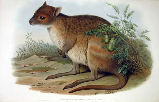
A vintage-style illustration showing a side profile of a spectacled hare-wallaby standing in a grassy area next to a small shrub.
A historical scientific illustration of a spectacled hare-wallaby, a marsupial native to the Australian landscape.

Mornington Sanctuary history and protected-area timeline

Mornington began its modern history as a pastoral lease in the Kimberley, running primarily as a beef cattle station for most of the twentieth century. The property was named after Victoria's Mornington Peninsula by Bob Maxted, reflecting the broader Australian pattern of settlers applying familiar southern names to remote northern holdings. As a working cattle property, the land was managed for grazing rather than ecological values, though the underlying tropical savanna and river systems of the Central Kimberley remained relatively undeveloped.

In 2001 the property was acquired by the Australian Wildlife Conservancy, marking a decisive shift from pastoral use to biodiversity conservation. The transformation from Mornington Station to Mornington Sanctuary reflected the growing role of private conservation organisations in protecting large tracts of Australian bush, particularly in regions where public reserve networks did not yet cover ecologically important country. Since acquisition, the reserve has been managed as a site for landscape-scale conservation, with active programs in fire management, wildlife monitoring, and feral animal control supporting the sanctuary's role as a refuge for threatened Kimberley species.

Mornington Sanctuary landscape and geographic character

The landscape of Mornington Sanctuary is defined by the dramatic geological contrasts of the Central Kimberley. In the south, a section of the Wunaamin-Miliwundi Ranges runs through the reserve, with vertically walled gorges such as Dimond Gorge cut by tributaries of the Fitzroy River. These deeply incised valleys create sheltered microhabitats and striking sandstone scenery that contrasts sharply with the open country elsewhere in the property.

To the north, the terrain flattens and rises again into the mesa formations of the Baulk Face Range and Fitzroy Bluff, with their characteristic flat-topped profiles. Lake Gladstone, the largest wetland in the Kimberley, occupies the north-western part of the reserve, adding expansive seasonal waterland to an otherwise rocky and savanna-dominated landscape. The upper catchment of the Fitzroy River ties these features together, channelling wet-season flows through gorges and across floodplains.

Vegetation cover is dominated by tropical savanna woodland and grassland, kept in a dynamic mosaic by frequent wildfires. Within sheltered gullies and rocky pockets protected from fire, small rainforest communities persist, including stands of Livistona palms. The interplay of sandstone country, mesas, river gorges, savanna, and seasonal wetlands gives Mornington a landscape profile that captures much of what makes the Kimberley distinctive.

Mornington Sanctuary ecosystems, habitats, and plant life

Mornington's ecological identity rests on its tropical savanna systems, shaped by climate and fire. The reserve is covered predominantly by various forms of tropical savanna woodland and grassland, maintained in a shifting mosaic by frequent wildfires that prevent encroachment by denser vegetation. This fire-driven pattern is central to the ecology of the Central Kimberley and supports the bird and mammal communities that depend on a mix of open grassland, scattered trees, and rocky refuge areas.

In fire-protected niches within gorges and sheltered gullies, fragments of more fire-sensitive vegetation persist, with Livistona palm forests among the most distinctive. These patches provide a glimpse into the more mesic plant communities that survive where fire intensity is reduced, adding botanical diversity to an otherwise savanna-dominated reserve. The combination of open woodland, palm-filled gorges, mesa slopes, and the seasonal wetland of Lake Gladstone gives the sanctuary a layered habitat structure.

The climate is tropical and monsoonal, with a distinct wet season from November to April and a dry season from May to October, bringing average annual rainfall of roughly 700 mm. This seasonality drives pulses of growth and flowering in the savanna, fills Lake Gladstone and other wetlands during the wet, and concentrates wildlife activity around remaining water during the dry. The climatic rhythm is integral to the functioning of the reserve's ecosystems.

Mornington Sanctuary wildlife and species highlights

Mornington Sanctuary has been recognised by BirdLife International as an Important Bird Area because of its significance for a suite of threatened and range-restricted species. The reserve supports important populations of red goshawks and Gouldian finches, the latter among the most visually striking and conservation-significant finches of northern Australia. Globally important populations of grey falcons, Australian bustards, chestnut-backed buttonquails, and bush stone-curlews also occur here, alongside rock-dwelling birds such as white-quilled rock-pigeons and sandstone shrike-thrushes.

A broad community of woodland and savanna birds thrives across the reserve, including varied lorikeets, northern rosellas, purple-crowned fairywrens, silver-crowned friarbirds, white-gaped, yellow-tinted, bar-breasted and banded honeyeaters, white-browed robins, spinifexbirds, painted firetails, masked finches and long-tailed finches. This diversity reflects the range of habitats available, from open grassland and woodland through to gorge country and seasonal wetland margins.

The sanctuary also provides habitat for mammals and reptiles of conservation concern. Freshwater crocodiles and northern quolls are among the threatened animals recorded from the reserve, while spectacled hare-wallabies, ghost bats, and orange leaf-nosed bats are considered likely to occur. The combination of rugged gorge refuge, expansive savanna, and large wetland habitat underpins the sanctuary's importance as a refuge for Kimberley wildlife.

Top sights and standout views in Mornington Sanctuary

Mornington combines the Wunaamin-Miliwundi Ranges and gorge systems with open tropical savanna and the Kimberley's largest wetland, Lake Gladstone. BirdLife International recognises it as an Important Bird Area, particularly for Gouldian finches and red goshawks. Active fire management and large-scale conservation by the Australian Wildlife Conservancy shape a landscape that protects both ecological processes and threatened species over a very large, contiguous estate.

Best time to visit Mornington Sanctuary

The tropical monsoonal climate strongly shapes when and how Mornington can be visited. The dry season, from May to October, is the practical window for overland access, when the rough four-wheel-drive roads off the Gibb River Road are typically open and Mornington Road is negotiable. During this period, water recedes from Lake Gladstone and the floodplains, concentrating wildlife around remaining water sources and making conditions more comfortable for visitors.

The wet season, from November to April, brings heavy rains that fill rivers, wetlands, and Lake Gladstone, transforming the savanna into a lush green landscape. However, this is also when roads are most likely to be closed and access becomes difficult or impossible for conventional travel. For visitors, the dry season generally provides both more reliable access and richer concentrations of terrestrial wildlife, while the wet season offers the most dramatic landscape transformation but limited practical access.

Monthly climate preview

Long-term representative point measurements for Western Australia terrain

Mornington Sanctuary Climate Normals and Annual Temperature Rhythm

Representative coordinates track annual temperature fluctuations from cooler winter months to hot monthly maximums alongside seasonal precipitation shifts. Detailed monthly data profiles document complete multiyear climate patterns across the protected landscape.
Annual mean27 °C
22 °C33 °C
Jan29°
Feb28°
Mar27°
Apr27°
May24°
Jun22°
Jul22°
Aug24°
Sep28°
Oct32°
Nov33°
Dec31°
Warmest month
November

32.6 °C

Coolest month
July

21.5 °C

Wettest month
February

7.6 mm/day

Driest month
August

0 mm/day

Park location guide

Geography guide, regional context, and park location map for Mornington Sanctuary

Mornington Sanctuary park geography, regions, and map view in Australia

Understand where Mornington Sanctuary sits in Australia through a broader geographic reading of the surrounding landscape, nearby location context, and its mapped position within the national park landscape.

How Mornington Sanctuary fits into Australia

Australia is a constitutional monarchy and federal parliamentary democracy comprising six states and ten territories. With a population of nearly 28 million, it is one of the world's most urbanised countries, with most people concentrated on the eastern seaboard. The country has a high Human Development Index and is known for its cultural diversity, ancient Aboriginal heritage, and unique wildlife.

Wider geography shaping Mornington Sanctuary in Australia

Australia occupies the entire Australian continent, the island of Tasmania, and numerous smaller islands. It is the world's flattest and driest inhabited continent, featuring vast deserts in the interior (the Outback), tropical rainforests along the eastern coast, and a coastline bordering the Indian and Pacific Oceans.

Map view of Mornington Sanctuary

Use this park location map to pinpoint Mornington Sanctuary in Australia, understand its exact geographic position, and read its mapped placement within the surrounding landscape more clearly.

Pigeon | © OpenStreetMap contributors

Location context for Mornington Sanctuary

Western Australia

Explore photographic records of sandstone gorges, tropical savanna, and protected wildlife habitats.

Mornington Sanctuary Photos and Scenery: Visualizing the Kimberley Wilderness

Visual records capture the rugged sandstone ranges, deep river gorges, and expansive tropical savanna defining Mornington Sanctuary. Examining these protected landscapes reveals the distinct geological features and remote habitats shaping Australia's conservation estate.

A vintage-style illustration showing a side profile of a spectacled hare-wallaby standing in a grassy area next to a small shrub.

Park atlas

Compare regional protected areas and connected savanna terrain across the Kimberley

Explore Other Parks Near Mornington Sanctuary and Surrounding Protected Landscapes

Browse nearby national parks and protected areas to compare the rugged gorges, sandstone mesas, and tropical savanna surrounding Mornington Sanctuary. Expanding the geographic view reveals how regional conservation estates and river catchments link across the wider Kimberley terrain.
National parkWestern Australia
About 51 km away#1 closest

Southwest

Bunuba National Park National Park: Mapped Protected Landscape and Regional Geography in Western Australia

Explore its protected land, geographic spread, and mapped boundaries.

Bunuba National Park is a protected area designated as a national park, situated in the vast region of Western Australia. This entry facilitates discovery of its mapped boundaries and the surrounding natural landscape, offering a specific geographic context. Understand how this protected land contributes to the regional atlas of Western Australia, providing a factual representation of its protected area status and landscape character for geographic exploration.

Area
2,200 km²
Established
2023
Scope
Terrestrial
Water
Major water bodies
National parkWestern Australia
About 62 km away#2 closest

Southwest

Danggu (Geikie) Gorge National Park: Western Australia's Protected Landscape Atlas

Explore the geography and mapped boundaries of this national park.

Danggu (Geikie) Gorge National Park is a vital protected area situated within the diverse geography of Western Australia. This entry provides a detailed atlas perspective, focusing on the park's mapped boundaries and its distinct landscape character. Explore the regional context and understand how this national park contributes to the protected lands of Western Australia, offering a grounded approach to geographic discovery.

Area
31.36 km²
Established
1967
IUCN
II
Relief
Mixed relief
National parkAustralia
About 73 km away#3 closest

Southwest

Geikie Gorge National Park: Discover Australia's Protected Landscape and Mapped Terrain

Explore the geography and park boundaries of this national park.

Geikie Gorge National Park represents a significant protected area within Australia, offering users a focused point for geographic exploration. This page details its identity as a national park, highlighting its mapped natural landscape and the regional context it occupies. Engage with structured information that clarifies its protected boundaries and natural terrain, contributing to a deeper atlas-based understanding of Australia's conservation areas.

National parkWestern Australia
About 78 km away#4 closest

South

Warlibirri National Park: Western Australia's Protected Landscape and Geographic Atlas Entry

Discover mapped boundaries and regional context within Western Australia.

Warlibirri National Park represents a distinct protected landscape within the vast geography of Western Australia. As a designated national park, it offers a specific point of atlas-driven exploration, detailing its geographic scope and protected status. This entry focuses on the core elements of Warlibirri National Park's identity for users seeking structured geographic and mapped landscape information.

Area
158.95 km²
Established
2021
Scope
Terrestrial
Water
Major water bodies
National parkWestern Australia
About 102 km away#5 closest

West

Tunnel Creek National Park: Ancient Devonian Reef Caves and Aboriginal Heritage

Discover Western Australia's ancient geological and cultural protected landscape.

Tunnel Creek National Park offers a unique glimpse into geological time and Aboriginal heritage, centered on an ancient underground river flowing through the Napier Range. This National Park features one of Western Australia's oldest cave systems, carved from fossilized Devonian reef limestone dating back 350 million years. Explore the remarkable 750-meter cave tunnel, marvel at its speleothems, and appreciate the significant rock art that tells stories of its cultural past. The park's protected status safeguards this extraordinary geological formation and its historical narratives for continued exploration.

Area
0.91 km²
Established
1992
IUCN
II
Relief
Upland
National parkWestern Australia
About 116 km away#6 closest

West

Windjana Gorge National Park: Ancient Devonian Reef Gorge Landscape Exploration

Explore mapped geography and fossil-rich sandstone formations.

Windjana Gorge National Park offers an unparalleled opportunity to explore a protected landscape defined by its ancient Devonian reef origins. Situated in Western Australia, this national park protects a dramatic gorge carved through fossil-rich sandstone, revealing a 375-million-year-old geological past. Examine the mapped park boundaries and the unique contours of this ancient reef system, providing crucial context for understanding the natural history and landscape evolution of the Kimberley region.

Area
20.5 km²
Established
1971
IUCN
II
Relief
Lowland
Nature reserveWestern Australia
About 160 km away#7 closest

East

Marion Downs Sanctuary: Protected Kimberley Nature Reserve and Tropical Savanna Map

Explore conservation geography and sandstone terrain in Western Australia.

Marion Downs Sanctuary is a expansive nature reserve located in the heart of the Kimberley region of Western Australia. The protected territory includes vast tropical savanna woodlands and rugged sandstone gorges linked to the Fitzroy River system. Gain insights into the mapped boundaries and natural terrain that make this location a vital refuge for diverse species within the broader Australian outback.

Area
2,890 km²
Established
2008
Relief
Upland
Climate
Tropical
National parkWestern Australia
About 177 km away#8 closest

North

Prince Regent National Park: Protected Landscape and Geographic Context in Western Australia

Explore mapped boundaries of this Western Australian national park.

Prince Regent National Park represents a distinct protected area within the expansive territory of Western Australia. This national park serves as a focal point for understanding regional geography and mapped landscape features. Users can explore its specific park boundaries and discover its contribution to the atlas of Western Australia's natural heritage, offering a deep dive into its protected status and geographic placement.

Area
5,764 km²
Established
1964
IUCN
II
Relief
Mountain

Common questions about visiting, size, designation, and location context for Mornington Sanctuary

Mornington Sanctuary FAQs for park facts, access, geography, and protected area context

Find quick answers about Mornington Sanctuary, including protected-area facts, park geography, trail and visitor context, and how the park fits into its surrounding country and regional landscape.
MoriAtlas Explorer

Continue Your Protected Areas Search Across the Global Atlas

Deepen your exploration by continuing the structured search for national parks and protected areas worldwide. Utilize the comprehensive filtering capabilities to compare different conservation landscapes and refine your understanding of global park geography. Discover more about the distribution and characteristics of protected natural areas.

Global natural geography