Mori Atlas logo
Protected landscapeMount Baker National Recreation Area

Tracing the mapped boundaries and terrain of this remote Cascade mountain wilderness

Mount Baker National Recreation Area: A Glaciated Volcanic Protected Landscape in Washington

Mount Baker National Recreation Area represents a significant protected landscape set deep within the northern Cascade mountains of Washington. This roadless wilderness area centers on the active stratovolcano of Mount Baker, where glaciers and snowfields sustain a dense network of cold streams, old-growth conifer forests, and alpine meadows. The terrain showcases a sharp vertical gradient from sheltered forest floors to exposed rocky ridges, offering a compressed look at the ecological diversity of the North Cascades.

Cascade mountainsglaciated volcanoalpine meadowsold-growth forestroadless backcountryhiking

Mount Baker National Recreation Area

Protected landscape

Park overview

Structured park overview, official facts, and landscape profile for Mount Baker National Recreation Area

Mount Baker National Recreation Area park facts, protected area profile, and essential visitor context

Review the core facts for Mount Baker National Recreation Area, including designation, size, terrain, visitor scale, habitats, and operating context in one park-focused overview.

About Mount Baker National Recreation Area

Mount Baker National Recreation Area occupies a remarkable slice of Washington's North Cascades, where active volcanism, heavy snowfall, and dense maritime forests combine to produce some of the most ecologically distinctive terrain in the contiguous United States. Located inside the Mount Baker-Snoqualmie National Forest and adjacent to North Cascades National Park, the recreation area lies near the Canadian border in Whatcom County, with the small community of Concrete serving as the nearest gateway town.

At the heart of the area stands Mount Baker, one of the most heavily glaciated peaks in the lower 48 states. Its volcanic flanks feed alpine glaciers such as the Coleman and Easton, which in turn supply meltwater to numerous rivers and streams that wind through the surrounding forests. The result is a landscape that blends high alpine environments with lush, water-rich lower elevations, creating an unusually broad range of habitat types within a relatively compact area.

The recreation area was created by Congress in 1984 specifically to protect this combination of wildlife habitat and recreational value. Because the area is roadless, almost every visitor enters on foot, skis, or snowshoes, which preserves a sense of solitude and continuity with the natural setting that would be hard to find in a more accessible reserve. Trails ranging from easier routes such as Park Butte Trail to more demanding climbs toward the Bell Pass area allow visitors to move through a full vertical gradient of vegetation, from lowland conifer forests into true alpine terrain.

Mount Baker's status as an active volcano adds a layer of geological significance to the recreation area. Historic lahars and hydrothermal explosions have shaped the surrounding valleys, and the region remains part of an active volcanic system monitored for future activity. This backdrop of living geology, combined with classic Pacific Northwest forests full of old growth, gives the recreation area a strong scientific and educational value beyond its recreational role.

Today, the area functions as a year-round outdoor destination. Summer brings hikers, climbers, horseback riders, and campers, while autumn draws visitors to harvest huckleberries and pursue hunting seasons. In winter, snow converts the recreation area into a region for snowshoeing, backcountry skiing, and snowmobiling where conditions allow. Through every season, the recreation area remains one of the most intact Cascade experiences in the Mount Baker-Snoqualmie National Forest.

Quick facts and research context for Mount Baker National Recreation Area

Mount Baker National Recreation Area is a unit of the Mount Baker-Snoqualmie National Forest in northwestern Washington State, covering roughly 8,600 acres of roadless backcountry along the slopes of Mount Baker. The area sits in Whatcom County, with the nearest town being Concrete, Washington, and lies about 15 miles south of the Canadian border.

Congress established the recreation area on July 3, 1984, the same day the adjacent Mount Baker Wilderness was created. The protection was designed to safeguard wildlife habitat and outdoor recreation values around Mount Baker rather than to highlight a single feature or monument.

Protection and recognition

Examine terrestrial protected area parameters and formal recognition records

Mount Baker National Recreation Area Protection Status and Regional Scope

Mount Baker National Recreation Area maintains documented terrestrial protection status within a managed conservation boundary. Public records outline the administrative framework and official designation history governing the mountain landscape.

Protection details

Protection scope
Terrestrial
Transboundary protection
No
Park context

Deeper park guide and search-rich context for Mount Baker National Recreation Area

Mount Baker National Recreation Area history, landscape, wildlife, and travel context

Explore Mount Baker National Recreation Area through its history, landscape character, ecosystems, wildlife, conservation priorities, cultural context, and seasonal travel timing in a structured park guide built for atlas discovery and search intent.

Why Mount Baker National Recreation Area stands out

Mount Baker National Recreation Area is best known for its dramatic glacier-clad Cascade scenery and its reputation as a roadless outdoor recreation area on the flanks of an active volcano. The recreation area offers access to the Coleman Glacier and Easton Glacier climbing routes on Mount Baker, alongside subalpine trails such as Park Butte Trail, Scott Paul Trail, and Bell Pass Trail. Equally important is the area's ecological richness. Cold glacial runoff supports dense stands of Douglas fir, Pacific silver fir, mountain hemlock, and western hemlock, creating forest communities that sustain bears, elk, deer, mountain goats, marmots, and bald eagles. The combination of accessible-yet-remote terrain, glacier-founded ecosystems, and a strong trail network is what gives the recreation area its distinctive identity within the broader North Cascades region.
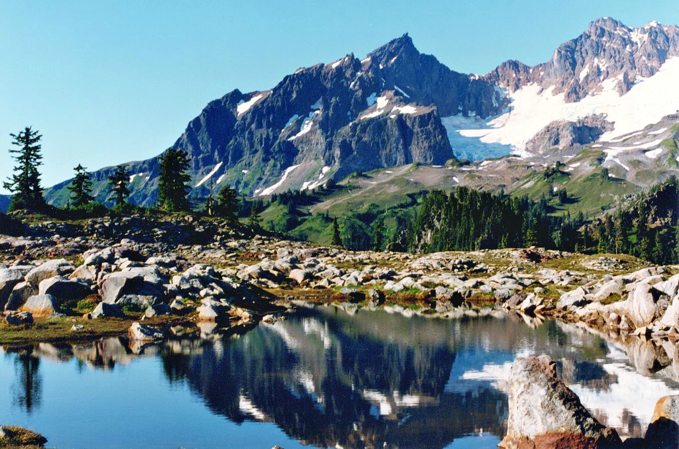
A clear mountain lake reflects the rugged, glacier-covered Black Buttes in the background, with rocky foreground terrain and small evergreen trees.
The dramatic Black Buttes reflected in an alpine pool within the Mount Baker National Recreation Area.

Mount Baker National Recreation Area history and protected-area timeline

The history of Mount Baker National Recreation Area traces back to 1893, when roughly 2.25 million acres were placed under federal protection as the Pacific Forest Reserve. The Mount Baker area fell within this enormous early reserve, making it part of one of the earliest federal forest designations in the Pacific Northwest.

In 1908, the Pacific Forest Reserve was divided. The northern portion, stretching from the Canadian border down to the Skagit River, became the Washington National Forest. The remainder from the Skagit River south to the Green River became the Mount Baker National Forest. These administrative boundaries continued to shift over the following decades, and in 1973 the Mount Baker and Snoqualmie National Forests were merged into today's Mount Baker-Snoqualmie National Forest.

The recreation area itself came into being on July 3, 1984, when Congress designated both Mount Baker National Recreation Area and the adjacent Mount Baker Wilderness on the same day. The dual designation reflected a balance between preserving the region's wildlife and ecological values and providing for traditional backcountry recreation. Since that time, the recreation area has remained a roadless, trail-based landscape within the broader national forest, governed by the United States Forest Service.

Mount Baker National Recreation Area landscape and geographic character

The landscape of Mount Baker National Recreation Area is dominated by the glaciated volcanic massif of Mount Baker and its surrounding ridges, valleys, and meadows. Glacial meltwater from the Coleman and Easton Glaciers feeds a network of cold, clear streams and rivers that carve through the lower terrain, while seasonal runoff from snowfields sustains the area's characteristic greenery well into the summer months.

At lower elevations, the terrain is shaped by dense conifer forests and rolling moraines shaped by past glacial activity. Higher up, subalpine ridges, exposed rocky slopes, and glacial basins open into sweeping views across the North Cascades. This sharp vertical gradient, compressed into a relatively compact area, creates a landscape that moves rapidly from sheltered forest to exposed alpine environment within a single day's hike.

The volcanic history of Mount Baker is visible in the topography as well. Past lahars associated with hydrothermal explosions in the 19th century altered valley floors and streambeds, and the broader volcanic edifice remains a defining landform that overlooks the entire recreation area.

Mount Baker National Recreation Area ecosystems, habitats, and plant life

The ecological richness of Mount Baker National Recreation Area stems from a combination of cold glacial water, abundant precipitation, and elevational diversity. Cold streams fed by alpine glaciers support sensitive aquatic habitats and river systems that define much of the area's identity, while maritime-influenced climate encourages unusually luxuriant forest growth at lower elevations.

Forests in the recreation area include towering stands of Douglas fir, along with Pacific silver fir, mountain hemlock, western hemlock, and even coastal redwoods in certain lower-elevation pockets. Cottonwoods grow along streambanks, and the vertical layering of species from valley floor to subalpine ridge produces the classic dense, multi-tiered canopy structure typical of the western Cascades. Above treeline, subalpine meadows and glacial basins support a different set of hardy plants adapted to short growing seasons and heavy snowpack.

This combination of habitats gives the recreation area unusually high ecological value for its size. The dense vegetation provides cover and forage for both large mammals and smaller species, while clean, cold water supports fish populations and riparian food webs that, in turn, sustain birds of prey and other predators.

Mount Baker National Recreation Area wildlife and species highlights

Mount Baker National Recreation Area supports a broad variety of wildlife, thanks to the diverse habitats created by its forests, rivers, and alpine zones. Large mammals such as black bears, Roosevelt elk, and deer are regular inhabitants of the lower forests and meadows, often moving through the same corridors used by hikers and horseback riders.

Higher, more rugged terrain provides habitat for mountain goats and marmots, both of which are well adapted to the rocky, glaciated slopes around Mount Baker. Streams and rivers flowing through the area are home to salmon and trout, reflecting the broader importance of the Skagit watershed for anadromous fish in the Pacific Northwest.

Birdlife is also a notable feature. Grouse inhabit the forested and meadow areas, while bald eagles and other raptors hunt along the rivers and open slopes. Together, this mix of mammals, fish, and birds gives the recreation area a wildlife profile that is unusually complete for a roadless protected area of its size in the Cascades.

Mount Baker National Recreation Area conservation status and protection priorities

The primary conservation significance of Mount Baker National Recreation Area lies in its role within the greater North Cascades ecosystem. Designated at the same time as the adjacent Mount Baker Wilderness in 1984, the recreation area helps buffer wilderness habitat while protecting wildlife corridors, riparian systems, and forest communities that depend on glacial cold-water input.

The area's roadless character is itself a major conservation asset. With no vehicle access through the interior, the landscape is sheltered from many of the fragmentation and disturbance pressures found in more accessible forested areas. This preserves old-growth forest stands, intact predator-prey relationships, and the natural hydrological patterns tied to glacial meltwater and seasonal snowpack.

Because Mount Baker remains an active volcano, the area also carries long-term geological and ecological monitoring value. The combination of living volcanic systems, glacial hydrology, and biodiverse Cascade forest communities is unusual in the contiguous United States, and the recreation area helps safeguard this integrated landscape for future study and protection.

Top sights and standout views in Mount Baker National Recreation Area

Mount Baker National Recreation Area stands out for its roadless, trail-based character, its setting on the flanks of a glacier-clad active volcano, and the density of classic Cascade habitats compressed into a relatively small area. Climbers, hikers, and backpackers are drawn to challenging routes such as the Coleman Glacier and Easton Glacier climbs, while less technical visitors gravitate to trails like Park Butte Trail, Railroad Grade Trail, and Bell Pass Trail.

Ecologically, the area's combination of old-growth conifer forests, salmon-bearing streams, alpine meadows, and large-mammal habitat makes it a rich showcase of North Cascades biodiversity. Its proximity to North Cascades National Park and its place within the Mount Baker-Snoqualmie National Forest give it both scenic and ecological importance well beyond its formal boundaries.

Best time to visit Mount Baker National Recreation Area

Summer is the most popular and accessible time to visit Mount Baker National Recreation Area, when snow has melted from most lower trails and the weather is generally favorable for hiking, climbing, camping, and horseback riding. Mid to late summer typically offers the best conditions on higher routes such as those approaching Mount Baker's glaciers, and the Park Butte area becomes a center for day hikes and wildflower viewing.

Late summer and early autumn also bring additional activities, including huckleberry picking and hunting in season. Winter transforms the recreation area into a snow-focused landscape suitable for snowshoeing, backcountry skiing, and, where conditions allow, snowmobiling, though deeper snowpack is required and access becomes far more demanding than in summer.

Monthly climate preview

Long-term monthly temperature averages and precipitation records across the protected terrain

Mount Baker National Recreation Area Climate Normals and Annual Weather Patterns

Representative coordinate records show measured monthly temperature variations alongside daily precipitation averages throughout the year. Examining the full monthly sequence provides detailed context on long-term climate normals across the protected landscape.
Annual mean7 °C
-1 °C16 °C
Jan-1°
Feb
Mar
Apr
May10°
Jun12°
Jul16°
Aug16°
Sep13°
Oct
Nov
Dec-1°
Warmest month
August

15.9 °C

Coolest month
December

-1 °C

Wettest month
November

10.6 mm/day

Driest month
July

1.5 mm/day

Park location guide

Geography guide, regional context, and park location map for Mount Baker National Recreation Area

Mount Baker National Recreation Area park geography, regions, and map view in United States of America

Understand where Mount Baker National Recreation Area sits in United States of America through a broader geographic reading of the surrounding landscape, nearby location context, and its mapped position within the national park landscape.

How Mount Baker National Recreation Area fits into United States of America

The United States of America is a federal presidential republic and one of the world's largest countries by area and population. It consists of 50 states across a vast territory spanning multiple time zones, with its capital in Washington, D.C. and largest city in New York City. The nation has a diverse economy, influential political system, and significant cultural and military presence globally.

Wider geography shaping Mount Baker National Recreation Area in United States of America

The United States occupies a vast territory in North America, bordered by Canada to the north and Mexico to the south. The 48 contiguous states stretch from the Atlantic to the Pacific Ocean, while Alaska occupies the northwestern region and Hawaii is an archipelago in the Pacific. The country encompasses diverse terrain including the Rocky Mountains, Appalachian Mountains, Great Plains, and extensive river systems.

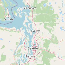
Map view of Mount Baker National Recreation Area

Use this park location map to pinpoint Mount Baker National Recreation Area in United States of America, understand its exact geographic position, and read its mapped placement within the surrounding landscape more clearly.

Pigeon | © OpenStreetMap contributors

Location context for Mount Baker National Recreation Area

WashingtonWhatcom County
Recorded earthquake history

Explore Historical Earthquake Records for Mount Baker National Recreation Area

Consult the MoriAtlas collection of historical seismic events recorded in the vicinity of Mount Baker National Recreation Area. This data-driven archive provides clear insights into past geological activity near these protected lands for researchers and enthusiasts.

Mount Baker National Recreation Area Earthquake History

Catalogued events

65 events

Strongest magnitude

Magnitude 5

Most recent event

May 17, 2022

This history includes earthquakes recorded inside the park or within 50 km of its borders

Visual exploration of glaciated mountain terrain and old growth forest habitats

Mount Baker National Recreation Area Photos and Volcanic Cascade Scenery

Visual records capture the rugged topography of Mount Baker National Recreation Area, showcasing active volcanic slopes, glacial valleys, and dense conifer forests. Examining protected area imagery provides a deeper understanding of remote alpine environments, dramatic ridge lines, and high altitude ecosystems across the northern Cascade range.

A clear mountain lake reflects the rugged, glacier-covered Black Buttes in the background, with rocky foreground terrain and small evergreen trees.

A lone snowboarder moves across a large, snow-covered landscape with a massive, jagged, snow-covered mountain peak looming in the background behind a cluster of evergreen trees.

Park atlas

Compare adjacent Cascade mountain wilderness and surrounding regional park geography

Explore Protected Areas and National Parks Near Mount Baker National Recreation Area

Discover related protected landscapes and nearby national parks that share the rugged volcanic terrain of the Pacific Northwest. Comparing adjacent mountain ecosystems helps reveal the broader ecological patterns shaping the regional terrain.
A watercolor painting showing a panoramic view of mountain peaks in the distance above green foothills and plains.
Protected landscapeWashington
Park boundaries overlap#1 closest

South

Mount Baker, Snoqualmie National Forest: Mapped Geography and Protected Landscape Analysis

Exploratory atlas of Washington's primary Cascade Range wilderness

Delve into the structural geography of Mount Baker, Snoqualmie National Forest. This protected area corridor serves as a major ecological transition zone between the Puget Sound lowlands and the interior Cascades, characterized by extensive glaciers, wild river systems, and iconic stratovolcanoes that define the regional landscape of Washington state.

Area
6,978 km²
Established
1974
Relief
Mountain
Climate
Alpine
A horizontal watercolor painting showing a range of purple-tinted mountain peaks above a green forest and a light pinkish shoreline.
Wildlife reserveWashington
Park boundaries overlap#2 closest

Northeast

Mount Baker Wilderness: Mapped Volcanic Peaks and Glacial Geography in Washington State

Protected wilderness boundaries in the Northern Cascades

Mount Baker Wilderness encompasses a vast mountain landscape characterized by an active stratovolcano and significant permanent snowfields. The terrain features a vertical gradient from dense west side conifer forests to exposed alpine summits, creating a distinct ecological corridor connected to neighboring protected areas in the Pacific Northwest.

Area
485.58 km²
Established
1984
IUCN
Ib
Relief
Mountain
National parkWashington
12 km away#3 closest

East

North Cascades National Park: US National Park Protected Landscape and Geographic Context

Explore mapped boundaries and regional Washington geography.

Gain insight into North Cascades National Park, a vital US National Park located in Washington. This entry focuses on its protected land status, mapped geographic extent, and its role within the regional atlas. Users seeking to understand the park's landscape character, natural terrain, and its specific location in Washington will find this an essential point for detailed park geography exploration and protected area discovery.

Area
2,042.26 km²
Established
1968
IUCN
II
Visitors
16.5K annual
A soft watercolor painting of a calm river or lake flowing through a green meadow with a forest and mountain range in the background.
Protected landscapeWashington
29 km away#4 closest

East

Ross Lake National Recreation Area: A Glacial Reservoir Landscape in Washington

Mapping the Skagit River and North Cascades alpine corridor

Located in the heart of Washington, Ross Lake National Recreation Area preserves a unique landscape of connected reservoirs and deep, glacier-cut valleys. This protected area acts as a vital geographic link within the North Cascades, offering access to high-altitude peaks, riverine forests, and the distinct turquoise waters of Diablo Lake.

Area
475.81 km²
Established
1968
IUCN
V
Visitors
998K annual
A soft watercolor illustration depicting a range of layered mountain peaks with green slopes and snow-covered summits against a white background.
Wildlife reserveWashington
39 km away#5 closest

Southeast

Glacier Peak Wilderness: Mapping the Volcanic and Glaciated Geography of Washington State

A detailed look at one of the most remote volcanic reserves in the Cascade Range.

Defined by the presence of an isolated stratovolcano and extensive glacial systems, Glacier Peak Wilderness represents a significant protected area within the Washington Cascades. This overview details the rugged landscape, from the deeply incised river valleys of the Chiwawa and Suiattle to the high-alpine rock and ice environment at the peak summit, providing essential geographic context for this roadless wilderness.

Area
2,290.75 km²
Established
1960
IUCN
Ib
Relief
Mountain
State or regional parkBritish Columbia
About 49 km away#6 closest

North

Ferry Island Provincial Park: Geography, Riparian Terrain, and Protected River Boundaries

A study of Fraser River alluvial landscapes and provincial park land use

Ferry Island Provincial Park provides a rare protected island setting along the Fraser River in British Columbia. Spanning 29 hectares near the Agassiz-Rosedale Bridge, this Class C park represents an important alluvial riparian ecosystem within the heavily cultivated Fraser Valley, offering key insights into regional river-corridor geography and protected land management.

Area
0.29 km²
Established
1963
IUCN
II
Access
Access unknown
State or regional parkBritish Columbia
About 53 km away#7 closest

North

Kilby Provincial Park: Protected Riverfront Geography and Historic Sites in BC

A unique riparian landscape along the Harrison River

Kilby Provincial Park offers an intimate look at the flood plain geography of the Harrison River. The site features an elevated, boardwalk-linked heritage environment integrated with sandy riverfronts and seasonal wildlife corridors. This protected area stands out for its combination of historical pioneer preservation and river-based ecosystem monitoring within the Upper Fraser Valley region of British Columbia.

Area
0.03 km²
Established
1973
IUCN
II
Relief
Lowland
A horizontal watercolor painting depicting a calm coastal inlet, surrounded by green hills, coniferous trees, and distant soft mountain silhouettes.
Marine protected areaUnited States of America
About 54 km away#8 closest

West

Padilla Bay National Estuarine Research Reserve: Coastal Protected Area Geography

A significant tidal estuary and marine protected landscape in Washington

This marine protected area encompasses large, shallow tidal mudflats and salt marshes within the Salish Sea. It serves as a essential hub for ecological research and conservation, framing a hybrid environment where historical diked farmlands meet protected coastal terrain. The reserve offers deep insight into the regional geography of Washington, detailing how tidal processes and human history have shaped this productive Pacific Northwest estuarine landscape.

Area
32 km²
Established
1980
Relief
Lowland
Access
Easy access

Common questions about visiting, size, designation, and location context for Mount Baker National Recreation Area

Mount Baker National Recreation Area FAQs for park facts, access, geography, and protected area context

Find quick answers about Mount Baker National Recreation Area, including protected-area facts, park geography, trail and visitor context, and how the park fits into its surrounding country and regional landscape.
MoriAtlas Explorer

Continue Your Protected Areas Search Across the Global Atlas

Deepen your exploration by continuing the structured search for national parks and protected areas worldwide. Utilize the comprehensive filtering capabilities to compare different conservation landscapes and refine your understanding of global park geography. Discover more about the distribution and characteristics of protected natural areas.

Global natural geography