
Mori Atlas logo
Nature reserveMünsterbusch zwischen Hamm und Haumühle

Mapped river valley landscapes, heavy metal grasslands, and ancient oak-hornbeam forest mosaics

Münsterbusch zwischen Hamm und Haumühle Nature Reserve in North Rhine-Westphalia, Germany

(Naturschutzgebiet Münsterbusch zwischen Hamm und Haumühle)

Münsterbusch zwischen Hamm und Haumühle represents a distinctive protected landscape within the Inde valley of North Rhine-Westphalia. Spanning roughly 103 hectares, this nature reserve preserves a complex ecological mosaic of floodplain forests, spring-fed brooks, and rare heavy metal grasslands shaped by centuries of regional metalworking. The protected area serves as an essential green corridor, connecting diverse habitats ranging from wet meadows to dry heath near the Brander Wald.

nature reserveriver valleyfloodplainInde riverheavy-metal grasslandmat-grass swards
Stylized graphic illustration depicting a valley with a winding river in the foreground, coniferous trees, and tall rocky cliffs in the background under a soft light.

Münsterbusch zwischen Hamm und Haumühle

Nature reserve

Park overview

Structured park overview, official facts, and landscape profile for Münsterbusch zwischen Hamm und Haumühle

Münsterbusch zwischen Hamm und Haumühle park facts, protected area profile, and essential visitor context

Review the core facts for Münsterbusch zwischen Hamm und Haumühle, including designation, size, terrain, visitor scale, habitats, and operating context in one park-focused overview.

About Münsterbusch zwischen Hamm und Haumühle

Münsterbusch zwischen Hamm und Haumühle is one of the more ecologically diverse nature reserves of the Städteregion Aachen, blending river floodplain habitats with the unusual metal-rich grasslands that are characteristic of the historic industrial hinterland of Stolberg. Although the total area is modest, around 103 hectares, the reserve concentrates an unusually wide range of near-natural habitat types within a short stretch of the Inde valley.

The two-component layout of the reserve, set between the districts of Münsterbusch and Atsch, reflects the valley geography of the region. The Inde (locally known in this section as the Münsterbach) flows along the western edge and around the southwestern boundary, while the L 221 state road runs along the northern margin. The protected landscapes thus occupy a transitional zone between river, valley slopes, and the higher wooded plateau that continues into the neighboring Brander Wald.

The reserve's conservation purpose is explicitly multi-layered: it protects near-natural running water sections and the water balance of the floodplain; it conserves heavy-metal and mat-grass swards, dry to wet heathland, and species-rich wet and moist meadows along with their fallow stages; it preserves near-natural spring brook stretches; and it safeguards semi-natural brook-floodplain forests featuring the giant horsetail as well as site-native oak-hornbeam forests, often managed as coppice. The framework plan for its protection is the Landschaftsplan Aachen, and the area is administered by the lower landscape authority of the Städteregion Aachen.

For visitors and researchers, the reserve provides a representative cross-section of the ecologically rich valley landscapes found east of Aachen, along with a clear example of how centuries of local metalworking have shaped distinctively species-rich vegetation in the region.

Quick facts and research context for Münsterbusch zwischen Hamm und Haumühle

Münsterbusch zwischen Hamm und Haumühle is a nature reserve (Naturschutzgebiet) in the Städteregion Aachen, North Rhine-Westphalia, administered by the lower landscape authority of Städteregion Aachen. It lies west of central Stolberg in the Inde valley, locally also called the Münsterbachtal, and comprises two separate parcels between the districts of Münsterbusch, Hamm, Haumühle and Atsch.

The site carries the official code ACK-015 and is registered internationally in the World Database on Protected Areas under ID 164714. It is formally classified as an IUCN Category IV habitat and species management area. The reserve adjoins the Brander Wald nature reserve (ACS-012) and is partly used by the Aachen-Brand military training ground, which has helped give parts of the landscape their open, semi-natural character.

Protection and recognition

Examine official conservation status, registry records, and international recognition details.

Münsterbusch zwischen Hamm und Haumühle Protection Status and Designated Area Record

Münsterbusch zwischen Hamm und Haumühle protection status records assemble verified administrative boundaries, official designation metrics, and documented conservation frameworks. Reviewing structured registry parameters provides transparent insight into baseline management scopes and international database identifiers.

Protection details

WDPA ID
164714
Park context

Deeper park guide and search-rich context for Münsterbusch zwischen Hamm und Haumühle

Münsterbusch zwischen Hamm und Haumühle history, landscape, wildlife, and travel context

Explore Münsterbusch zwischen Hamm und Haumühle through its history, landscape character, ecosystems, wildlife, conservation priorities, cultural context, and seasonal travel timing in a structured park guide built for atlas discovery and search intent.

Why Münsterbusch zwischen Hamm und Haumühle stands out

The reserve is best known for its rare combination of heavy-metal grasslands and mat-grass swards together with near-natural brook floodplain forests. These plant communities are the products of centuries of metalworking and smelting activity in the Stolberg region, where soils enriched with heavy metals have produced specialized grassland vegetation of high botanical value. Equally distinctive are the old oak-hornbeam woodlands along the Inde, with their coppice structure, ancient individual trees, and abundant dead wood, which harbor the giant horsetail (Riesen-Schachtelhalm) along shaded brook margins. Together with the heath, wet meadow and spring-brook communities, these habitats give the reserve an unusually layered ecological profile for a lowland valley in western Germany.
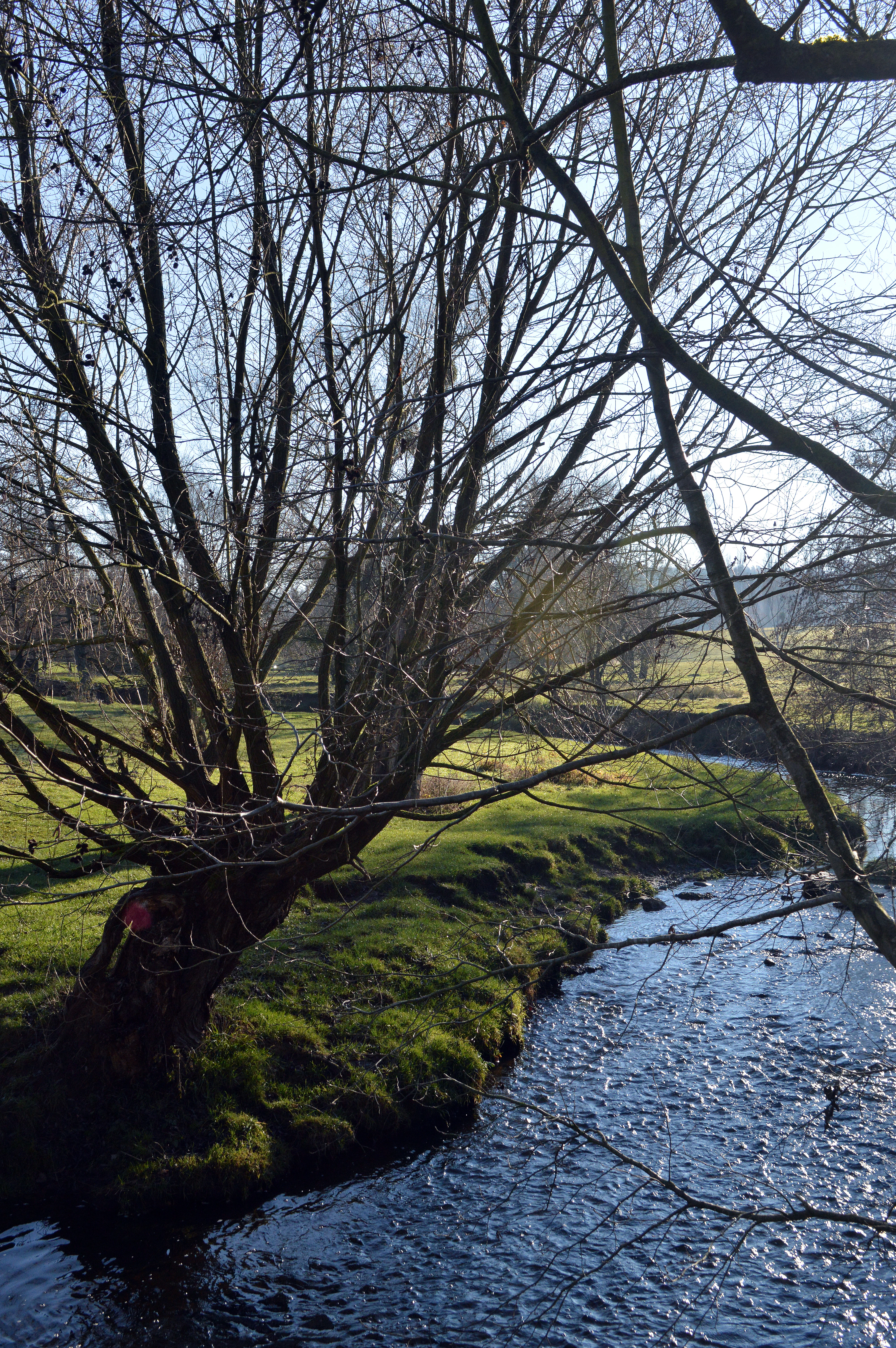
A view of the Inde River winding through a grassy landscape in early winter, with a large, leafless willow tree in the foreground.
The Inde River flowing through the Münsterbusch zwischen Hamm und Haumühle nature reserve.

Münsterbusch zwischen Hamm und Haumühle history and protected-area timeline

The area that now forms the Münsterbusch zwischen Hamm und Haumühle reserve was first placed under formal nature protection in 1985 under the code ACK-015, with conservation goals that combined hydrological protection of the Inde valley floodplain with the safeguarding of its characteristic grassland and woodland communities.

In 2004, the designation and framework of the protected area were formally updated and registered within the structure of the Landschaftsplan Aachen, aligning its management with the wider network of reserves in the Städteregion Aachen. The site has since remained under the administration of the lower landscape authority of the Städteregion.

Beyond formal protection status, much of the reserve's open and semi-open character is the result of earlier land use. Historical metalworking and smelting in the Stolberg area enriched local soils with heavy metals, creating the conditions for the heavy-metal grasslands still protected today, while traditional coppice management shaped the ancient oak-hornbeam woodlands with their veteran trees and dead-wood structures.

Münsterbusch zwischen Hamm und Haumühle landscape and geographic character

The reserve sits in the valley of the Inde, which in this stretch is also referred to as the Münsterbach, giving the local name Münsterbachtal to the area. The Inde flows along the western boundary and curves around the southwestern edge of the protected zone, shaping a narrow floodplain that contrasts with rising valley slopes and the wooded plateau beyond.

The terrain combines low, periodically wet floodplain sections with drier slopes and plateaus. Along the river banks, soft alluvial soils support wet meadows, brook-floodplain forests and spring brooks, while higher ground carries the drier plant communities that give the reserve its botanical interest. On the northern margin, the landscape meets the L 221 state road, which forms a clear boundary between the reserve and the urbanized surroundings of Stolberg.

To the west and south, the protected area connects visually and ecologically with the Brander Wald, a large contiguous forest that extends toward the Aachen-Brand military training area. The combination of valley floor, slopes, and adjacent high forest gives the reserve a varied topographic setting despite its relatively small size.

Münsterbusch zwischen Hamm und Haumühle ecosystems, habitats, and plant life

The ecological profile of the reserve is built on the interaction between water, soil chemistry, and traditional land use. The Inde and its tributary springs create a network of near-natural flowing water sections and spring brooks whose water balance supports both forest and meadow habitats along the floodplain.

A defining element of the site's ecology is its heavy-metal and mat-grass swards, plant communities that have developed on soils enriched with metals from the long history of smelting and metalworking in the Stolberg region. These specialized grasslands are ecologically rare and contribute significantly to the reserve's botanical value. Around them, the reserve protects dry to wet heath communities and species-rich wet and moist meadows, including fallow stages that maintain habitat continuity.

The woodlands of the valley are equally important. Brook-floodplain forests featuring the giant horsetail occur along shaded, water-influenced stretches, while site-native oak-hornbeam forests, often managed as coppice, dominate the higher slopes and valley margins. Management aims actively promote the development of these near-natural deciduous stands, the retention of dead wood, and the conservation of ancient individual trees, tree rows, and tree groups that define the valley's structure.

Münsterbusch zwischen Hamm und Haumühle wildlife and species highlights

Although the available source material focuses primarily on the vegetation of the reserve, the habitats present strongly support the presence of characteristic valley wildlife. The mosaic of wet meadows, heath, shrub edges, and structurally rich oak-hornbeam forests with abundant dead wood provides feeding, breeding, and shelter opportunities for a range of bird, insect, and small mammal species typical of western German lowland valleys.

The flowing water sections of the Inde and the spring brooks offer habitat for stream invertebrates and other aquatic fauna characteristic of near-natural lowland brooks in the Aachen region. The combination of open grassland, transitional heath, and woodland edge also creates valuable conditions for pollinators and for bird species associated with structured valley landscapes.

Münsterbusch zwischen Hamm und Haumühle conservation status and protection priorities

Conservation in Münsterbusch zwischen Hamm und Haumühle centers on maintaining the hydrological integrity of the Inde valley and on protecting a tightly linked set of habitats that depend on one another. The hydrological regime of the brook and its floodplain is treated as a conservation asset in its own right, underpinning the wet meadows, spring brooks, and brook-floodplain forests.

A particular conservation priority is the safeguarding of heavy-metal grasslands and mat-grass swards, which represent nationally and regionally rare vegetation types linked to the historic metalworking heritage of Stolberg. Equally important is the care of dry to wet heath communities, wet and moist meadows, and their fallow stages, all of which maintain open habitat in a region otherwise dominated by forest and urban land.

In woodlands, conservation measures include the protection, maintenance, and development of near-natural deciduous forests with site-native species, the promotion of veteran trees and dead wood, and the preservation of traditional coppice structures. The reserve's status as an IUCN Category IV habitat and species management area reflects this combination of active habitat care and species protection. Its proximity to the Brander Wald and the Aachen-Brand military training area also gives it a role within the larger ecological network of the Städteregion Aachen.

Münsterbusch zwischen Hamm und Haumühle cultural meaning and human context

The reserve's cultural significance is closely tied to the industrial heritage of Stolberg, which for centuries was a center of metalworking and smelting in the Aachen region. The metal-enriched soils left behind by this activity, rather than being merely an industrial legacy, are now the basis for one of the reserve's most distinctive ecological features, its heavy-metal grasslands.

Traditional coppice woodland management has also shaped the valley's older oak-hornbeam forests, and the dense network of historical mills, smelting works, and small settlements such as Buschmühle and Haumühle gave the valley its working, inhabited character for centuries. Today, the protected area preserves both the ecological and the layered cultural memory of this stretch of the Inde valley.

Top sights and standout views in Münsterbusch zwischen Hamm und Haumühle

The reserve's highlights include the rare heavy-metal grasslands and mat-grass swards of the Stolberg valley, the near-natural stretches of the Inde with their associated brook-floodplain forests, and the ancient oak-hornbeam coppice woods rich in veteran trees and dead wood.

Also notable is the reserve's compact mosaic of contrasting habitats, from wet meadows and spring brooks to dry heath and deciduous forest, all within a short stretch of the Inde valley. Its position next to the Brander Wald reserve and partial use as the Aachen-Brand military training area adds to its character as a working, ecologically rich landscape on the edge of the Aachen urban region.

Best time to visit Münsterbusch zwischen Hamm und Haumühle

The reserve can be appreciated in any season that allows safe walking along its edges and connecting paths, but late spring and early summer are typically the most rewarding for viewing heath, meadows, and heavy-metal grasslands in flower. Autumn can also be attractive for the structural color of the oak-hornbeam forests and the quieter atmosphere along the Inde valley.


Monthly climate preview

Long term temperature and precipitation normals recorded at a representative coordinate

Münsterbusch zwischen Hamm und Haumühle Climate and Monthly Weather Patterns

Representative measurements from 1991 to 2020 establish the baseline annual temperature and precipitation rhythm across Münsterbusch zwischen Hamm und Haumühle. Detailed month by month climate normals reveal the full range of historical variations at the sampled coordinate.
Annual mean10 °C
2 °C19 °C
Jan
Feb
Mar
Apr10°
May14°
Jun17°
Jul19°
Aug19°
Sep15°
Oct10°
Nov
Dec
Warmest month
July

19 °C

Coolest month
January

1.8 °C

Wettest month
December

2.4 mm/day

Driest month
April

1.5 mm/day

Park location guide

Geography guide, regional context, and park location map for Münsterbusch zwischen Hamm und Haumühle

Münsterbusch zwischen Hamm und Haumühle park geography, regions, and map view in Germany

Understand where Münsterbusch zwischen Hamm und Haumühle sits in Germany through a broader geographic reading of the surrounding landscape, nearby location context, and its mapped position within the national park landscape.

How Münsterbusch zwischen Hamm und Haumühle fits into Germany

Germany is a federal republic in Western and Central Europe with a population of over 83 million across sixteen constituent states. It is Europe's largest economy by nominal GDP and a major global exporter and importer. The capital is Berlin, and the country borders Denmark, Poland, Czech Republic, Austria, Switzerland, France, Luxembourg, Belgium, and the Netherlands.

Wider geography shaping Münsterbusch zwischen Hamm und Haumühle in Germany

Germany is located in Western and Central Europe, spanning 357,022 km². It borders Denmark to the north, Poland and the Czech Republic to the east, Austria and Switzerland to the south, and France, Luxembourg, Belgium, and the Netherlands to the west. The country has coastlines on the Baltic Sea and North Sea to the north, with the Alps located in the southern region.

Map view of Münsterbusch zwischen Hamm und Haumühle

Use this park location map to pinpoint Münsterbusch zwischen Hamm und Haumühle in Germany, understand its exact geographic position, and read its mapped placement within the surrounding landscape more clearly.

Pigeon | © OpenStreetMap contributors

Location context for Münsterbusch zwischen Hamm und Haumühle

North Rhine-Westphalia
Recorded earthquake history

Explore the Historical Earthquake Catalogue for Münsterbusch zwischen Hamm und Haumühle

Review the archive of seismic events recorded near the Münsterbusch zwischen Hamm und Haumühle nature reserve. This MoriAtlas dataset organizes historical data to provide clarity on the seismic activity documented within the Inde valley and surrounding North Rhine-Westphalia region.

Münsterbusch zwischen Hamm und Haumühle Seismic History

Catalogued events

75 events

Strongest magnitude

Magnitude 4.8

Most recent event

Dec 8, 2008

This history includes earthquakes recorded inside the park or within 50 km of its borders

Visualizing the terrain, river floodplains, and protected habitats of the reserve

Münsterbusch zwischen Hamm und Haumühle Photos and Landscape Scenery

Visual documentation captures the varied terrain, near-natural brook corridors, and specialized vegetation of Münsterbusch zwischen Hamm und Haumühle. Examining these protected-area photographs reveals the distinct ecological character of the river valley and its surrounding forest environments.

A view of the Inde River winding through a grassy landscape in early winter, with a large, leafless willow tree in the foreground.

Park atlas

Compare surrounding valley landscapes and regional nature reserves

Explore Protected Areas and Parks Near Münsterbusch zwischen Hamm und Haumühle

Browsing other protected areas near Münsterbusch zwischen Hamm und Haumühle reveals connected river valleys and regional forest reserves across western Germany. Examining adjacent nature reserves provides deeper geographic context for the specialized habitats and lowland terrain found throughout the Aachen region.
A watercolor painting showing a soft green landscape with rolling hills, a small pond, and trees under a white background.
Nature reserveStädteregion Aachen
About 4.1 km away#1 closest

Southeast

Naturschutzgebiet Schlangenberg: A Geographic Profile of Protected Mining Landscapes

Rare heavy metal habitats in the Städteregion Aachen

Naturschutzgebiet Schlangenberg serves as a protected ecological island featuring specialized Galmei flora that thrives on toxic zinc-rich soils. The reserve offers a clear look at how geological formation and historic mining practices created a unique steppe-like terrain, supporting diverse butterfly populations and rare botanical species within the North Rhine-Westphalia landscape.

Area
1.237 km²
Established
1975
IUCN
IV
Relief
Upland
A wide panoramic watercolor painting showing a landscape with a winding light green river or meadow in the foreground, a band of green trees in the middle ground, and purple mountains in the background against a white sky.
Nature reserveNordrhein-Westfalen
About 4.7 km away#2 closest

South

Naturschutzgebiet Schomet: Mapping the Protected Limestone Ridge and Reclaimed Quarry Landscapes

Nature reserve geography in Stolberg, Nordrhein-Westfalen

Examine the distinct geomorphology of Naturschutzgebiet Schomet, where abandoned Carboniferous limestone quarries have evolved into sheltered refuges for hornbeam forest and spring flora. This protected area offers insight into the regional geology of the Eifel foothills, showcasing how human-modified landscapes serve as important ecological corridors for amphibians and rare butterfly species within the broader Stolberg municipal network.

Area
12.81 km²
Established
2005
IUCN
IV
Nature reserveGermany
About 5.8 km away#3 closest

Northeast

Korkus Nature Reserve: A Detailed Geographic Overview of Protected Woodland in Germany

Mapping the historic mining terrain and stream-valley ecology

Korkus Nature Reserve offers a focused view into the woodland mosaic of the Städteregion Aachen. This protected area preserves a unique synthesis of stream-bordered forest and remnants of ancient iron extraction, providing a distinct geographic footprint within the broader context of North Rhine-Westphalia.

Area
5.208 km²
Established
1990
IUCN
IV
A horizontal watercolor illustration depicting rolling, soft-toned hills and a line of stylized trees in greens and pinks against a white background.
Nature reserveNordrhein-Westfalen
About 7.9 km away#4 closest

South

Naturschutzgebiet Schmithof: A Geological and Ecological Protected Area in Nordrhein-Westfalen

Mapped limestone quarries and traditional coppice forest landscapes

Located within the Städteregion Aachen, Naturschutzgebiet Schmithof protects a significant conjunction of geological and biological values. The site features an abandoned limestone quarry set against a backdrop of historic oak-hornbeam forest. This reserve provides a clear window into the local terrain, where calcareous grassland soils support rare flora and reflect ongoing habitat succession within a protected landscape context.

Area
0.048 km²
Established
1988
IUCN
IV
Relief
Lowland
Nature reserveGermany
About 8.2 km away#5 closest

Southwest

Wurmtal Nature Reserve: Mapping the Protected River Valley and Floodplain Geography

Protected riparian habitat in North Rhine-Westphalia

Wurmtal protects a diverse river corridor characterized by free-meandering stretches, soft-wood floodplain forests, and distinct industrial-heritage landmarks. This atlas entry provides insight into the valley's structural geography, including its steep erosion cliffs, gravel-bed river dynamics, and role as a significant ecological migration route within the regional landscape.

Established
1989
Relief
Lowland
Scope
Terrestrial
Water
Water-dominated
A soft watercolor illustration showing a winding river flowing through a forested valley with gentle rolling hills in the background.
Nature reserveGermany
About 11 km away#6 closest

South

Naturschutzgebiet Oberlauf der Inde im Münsterwald: Germany Protected Nature Reserve Atlas

Headwater streams and rare wetland habitats in the Aachen region.

Situated in the Münsterwald near Aachen, this nature reserve protects the intact headwaters of the Inde and Fobisbach streams. The area is characterized by a complex, compact landscape of alder carr, spring-fed bogs, and Molinia grasslands, offering a rare window into the natural hydrology and wetland vegetation of the region.

Area
0.299 km²
Established
1988
Relief
Upland
Climate
Temperate
A watercolor painting depicting rolling, soft-toned green hills and a foreground of trees and riparian vegetation.
Nature reserveNorth Rhine-Westphalia
About 11 km away#7 closest

South

Laubwald am Hasselbachgraben Nature Reserve in North Rhine-Westphalia

Protected Eifel forest and riparian stream landscape

Located in the Städteregion Aachen, Laubwald am Hasselbachgraben preserves a distinct mix of European beech, oak, and spruce. The reserve is anchored by the Hasselbach stream valley and the landmark Kreitzberg Naturwaldzelle, providing a critical study of near-natural woodland structure within the northern Eifel region.

Area
2.88 km²
Established
1999
IUCN
IV
Relief
Upland
Watercolor painting of a rolling stream valley with soft green hills and light water
Nature reserveStädteregion Aachen
About 15 km away#8 closest

Southeast

Kelzer- und Saarscher Bachtal: Protected Brook Valley Geography and Forest Terrain

Nature reserve exploration in the Städteregion Aachen landscape

The Kelzer- und Saarscher Bachtal nature reserve protects a vital network of brook valley habitats, including deciduous forest remnants, wet heath, and cascading stream sections. This area offers a clear look at local hydrologic restoration and the structural diversity found within the Eifel district, providing a focused view for those interested in regional protected-land geography.

Area
0.46 km²
Established
1999
IUCN
IV

Common questions about visiting, size, designation, and location context for Münsterbusch zwischen Hamm und Haumühle

Münsterbusch zwischen Hamm und Haumühle FAQs for park facts, access, geography, and protected area context

Find quick answers about Münsterbusch zwischen Hamm und Haumühle, including protected-area facts, park geography, trail and visitor context, and how the park fits into its surrounding country and regional landscape.
MoriAtlas Explorer

Continue Your Protected Areas Search Across the Global Atlas

Deepen your exploration by continuing the structured search for national parks and protected areas worldwide. Utilize the comprehensive filtering capabilities to compare different conservation landscapes and refine your understanding of global park geography. Discover more about the distribution and characteristics of protected natural areas.

Global natural geography