
Mori Atlas logo
Nature reserveMußbacher Baggerweiher

Mapping the ecological transition of post-industrial aquatic habitats and shoreline mosaics

Mußbacher Baggerweiher Nature Reserve in Rhineland-Palatinate: A Mapped Protected Area Discovery

(Naturschutzgebiet Mußbacher Baggerweiher)

Mußbacher Baggerweiher represents a significant protected nature reserve situated in the eastern outskirts of Neustadt an der Weinstraße. This former gravel extraction site for the A65 autobahn has been successfully repurposed into a complex aquatic wetland, serving as a vital biodiversity mosaic within the broader agricultural landscape of the Pfalz region. The area features a unique configuration of open water, damp shoreline depressions, and emerging islands that illustrate a successful recovery of natural habitats from industrial origins.

gravel pit lakenature reservewetlandaquatic habitatpost-industrial landscapebiodiversity mosaic
A graphic illustration of a lake landscape featuring soft-toned hills, trees, and cloudy skies in pastel colors.

Mußbacher Baggerweiher

Nature reserve

Park overview

Structured park overview, official facts, and landscape profile for Mußbacher Baggerweiher

Mußbacher Baggerweiher park facts, protected area profile, and essential visitor context

Review the core facts for Mußbacher Baggerweiher, including designation, size, terrain, visitor scale, habitats, and operating context in one park-focused overview.

About Mußbacher Baggerweiher

Mußbacher Baggerweiher is a small lake and designated nature reserve on the eastern edge of Neustadt an der Weinstraße. Although it lies only a short distance from major transport infrastructure, including the Mannheim–Saarbrücken railway line to the south and the A65 autobahn to the west, the site has been formally protected since 1989 and now functions as an important local refuge for wetland species within an otherwise intensively used agricultural and peri-urban landscape.

The lake sits within the locality of Mußbach an der Weinstraße, one of several village districts of Neustadt an der Weinstraße that retain a strong identity linked to wine growing and traditional Pfalz rural culture. The surrounding region is shaped by vineyards, small forest patches, and the geological transition zone of the Haardtrand, which marks the edge of the Palatinate Forest against the Upper Rhine Plain. In this context, the lake stands out as a comparatively rare, substantial open-water habitat.

The defining ecological significance of Mußbacher Baggerweiher lies in the combination of an open-water body with vegetated shoreline, shallow marginal zones where water levels fluctuate, and surrounding terrestrial habitats. As the water level in the lake has gradually decreased over time, small islands have emerged, further increasing the structural diversity of the site. The result is a compact but habitat-rich zone that supports a wide range of species relative to its size.

Because the area is a nature reserve, bathing and other recreational uses of the water are prohibited, even though the lake is sometimes used informally for swimming despite this status. The site therefore plays a more ecological than recreational role within the region, and its management is oriented toward preserving the mosaic of biotope types that originally motivated its protection.

Quick facts and research context for Mußbacher Baggerweiher

Mußbacher Baggerweiher is a lake and nature reserve located in the eastern cadastral area of the independent city of Neustadt an der Weinstraße, in the German state of Rhineland-Palatinate.

The lake has a surface area of about 7.5 hectares and extends roughly 500 meters in length by 150 meters in width. Including its immediate shoreline, the protected area covers approximately 20.53 hectares. The reserve is officially recorded under the German designation numbers 7316-108 and WDPA 164740. It sits within the Haardtrand region of the Pfalz, a landscape closely associated with viticulture and a mosaic of dry and wet habitats.

Protection and recognition

Examine documented conservation data, management scope, and recognition history

Mußbacher Baggerweiher Protection Status and Official Designation Records

Mußbacher Baggerweiher brings together verified conservation data, official designation records, and international tracking metrics for environmental analysis. Designated protection frameworks and source documentation provide clear context for ongoing natural resource management.

Protection details

WDPA ID
164740
Park context

Deeper park guide and search-rich context for Mußbacher Baggerweiher

Mußbacher Baggerweiher history, landscape, wildlife, and travel context

Explore Mußbacher Baggerweiher through its history, landscape character, ecosystems, wildlife, conservation priorities, cultural context, and seasonal travel timing in a structured park guide built for atlas discovery and search intent.

Why Mußbacher Baggerweiher stands out

Mußbacher Baggerweiher is best known for being a former gravel-extraction lake that has been successfully transitioned into a protected nature reserve. Its defining ecological feature is the diversity of habitat types concentrated in a very small area: the open water, transitional shoreline zones, newly formed small islands, and surrounding terrestrial habitats together create what conservation authorities describe as a varied mosaic of biotope types. The lake is also notable for its origin story, since the water body was excavated specifically to supply construction material for the A65 autobahn. This industrial genesis gives the site a distinctive character that contrasts with naturally formed lakes in the same region and makes it a frequently cited local example of how extraction landscapes can be repurposed for biodiversity conservation.
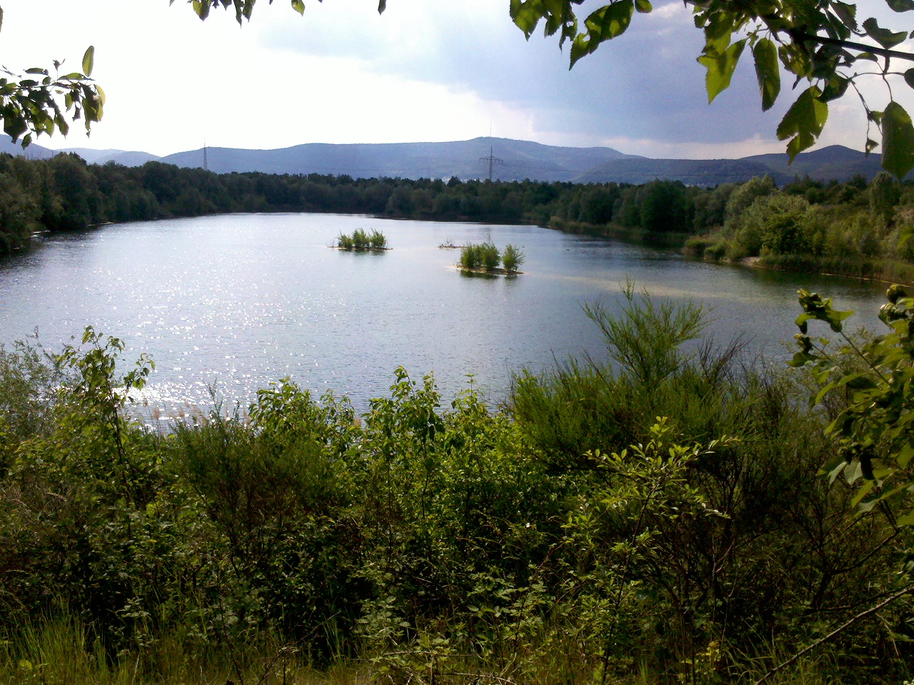
A landscape view overlooking a calm, reflective lake with small islands of vegetation, surrounded by dense trees and shrubs, with distant rolling hills under a cloudy sky.
View of the Mußbacher Baggerweiher lake.

Mußbacher Baggerweiher history and protected-area timeline

The lake at Mußbacher Baggerweiher has no natural origin: it was created between 1978 and 1984 as a gravel extraction pit. The material removed from the site was used in the construction of the nearby A65 federal autobahn, which was being built during that period. Once extraction operations ceased, the former quarry pit gradually filled with water, transforming the industrial excavation site into a permanent lake.

In 1989, only a few years after completion of the digging phase, the lake together with its immediate shoreline was formally designated as a nature reserve, reflecting the rapid ecological recovery and habitat value of the newly formed water body. The protected area as a whole covers roughly 20.53 hectares and is registered in German conservation records under the designation 7316-108, as well as internationally through the World Database on Protected Areas under WDPA-ID 164740.

Over the years following protection, the lake continued to evolve naturally. A gradual decline in water level has led to the formation of several small islands within the lake, an unplanned but ecologically significant development that has added further structural complexity to the habitat. Although the reserve legally prohibits bathing, an enforcement challenge remains: visitors occasionally ignore the bathing ban, reflecting local tension between informal recreational use and conservation protection.

Mußbacher Baggerweiher landscape and geographic character

The landscape of Mußbacher Baggerweiher is defined by an elongated open-water body of roughly 500 by 150 meters, set in a broader matrix of agricultural land and transport corridors typical of the eastern edge of Neustadt an der Weinstraße. The lake has a clearly artificial geometry, reflecting its origin as a quarry pit, with relatively straight shorelines shaped by the sequence of extraction cells.

A key visual feature of the lake is the presence of small islands that have emerged in recent decades. As water levels have dropped slowly since the site was protected, shallow sections of the lake bed have risen above the water line, creating isolated patches of land that contribute to the visual complexity of the site. These islands interrupt what would otherwise be a uniform open expanse of water and add to the habitat variability visible from the shoreline.

Surrounding the lake is a varied mosaic of shoreline vegetation, damp depressions, and adjacent terrestrial habitats that together characterize the protected area. Although the immediate setting is partly shaped by the proximity of the railway embankment and the autobahn, both of which pass close to the reserve, the lake and its banks retain a notably natural character that contrasts with the heavily engineered surroundings.

Mußbacher Baggerweiher ecosystems, habitats, and plant life

The ecological identity of Mußbacher Baggerweiher is built around the contrast between open water and a richly structured shoreline environment. The aquatic zone, the shallow transitional margins, and the surrounding terrestrial habitats together support a mosaic of different biotope types that conservation authorities have highlighted as the principal reason for protection. The result is a small but unusually diverse ecological system within an otherwise heavily cultivated landscape.

A particularly important ecological feature is the presence of small islands that have formed as water levels in the lake have gradually decreased. These islands provide protected breeding and roosting habitat for waterbirds and create sheltered microhabitats along their shorelines. Together with the variable water levels, this dynamic has steadily enriched the structural diversity of the site since it was first designated.

The reserve also functions as a local refuge for wetland-associated flora and fauna in the eastern outskirts of Neustadt. Although the lake and its banks are embedded in a setting otherwise dominated by vineyards, fields, and infrastructure, the site represents a relatively rare aquatic and wetland complex in the immediate area, contributing meaningfully to habitat diversity at the local and regional scale.

Mußbacher Baggerweiher wildlife and species highlights

Mußbacher Baggerweiher supports the kinds of waterbird communities typically associated with small, structured lowland lakes in southwestern Germany. The combination of open water, vegetated shoreline, and newly formed islands creates nesting and feeding conditions for a range of species that depend on aquatic habitats, especially in a regional context where such conditions are relatively scarce outside the larger river systems of the Upper Rhine Plain.

The mosaic character of the reserve also benefits amphibians and invertebrates that rely on the transition between water and land. Variation in water depth and shoreline structure, along with fluctuating water levels, generates a patchwork of microhabitats that supports breeding populations of common wetland species. The surrounding terrestrial habitats offer additional shelter and foraging areas for the broader faunal community.

Although the lake is small and situated near significant transport infrastructure, its protected status and habitat diversity give it disproportionate value as a refuge for wildlife in the eastern Neustadt area. Its role is less about hosting rare or charismatic species and more about maintaining a functioning wetland complex in a landscape where such habitats have become increasingly fragmented.

Mußbacher Baggerweiher conservation status and protection priorities

The conservation value of Mußbacher Baggerweiher lies in the recognition of a habitat mosaic that is unusual for its immediate context and unusually rich given its small size. When the site was formally designated as a nature reserve in 1989, the justification explicitly referenced the diversity of biotope types concentrated around the lake and its shoreline. That designation remains the central pillar of the site's conservation framework.

Protection covers both the lake itself and the surrounding shoreline belts, together totaling roughly 20.53 hectares. The reserve is recorded nationally under number 7316-108 and internationally under WDPA-ID 164740, giving the site formal standing in both German and global protected-area databases. This registration supports monitoring, planning, and potential cross-border conservation comparisons.

Because the lake originated through industrial gravel extraction rather than natural processes, its continued ecological development depends on ongoing management rather than passive protection alone. Water-level fluctuations, island formation, vegetation succession along the banks, and conflicts with informal recreational use, including occasional unauthorized bathing, all require regular attention. The site therefore represents an active conservation case study in how to manage a post-industrial water body for biodiversity outcomes.

Top sights and standout views in Mußbacher Baggerweiher

Mußbacher Baggerweiher stands out for the unusually rich habitat mosaic compressed into a very small area at the edge of Neustadt an der Weinstraße. The combination of artificial lake, sheltered shoreline, and newly formed islands gives the site a structural complexity that belies its modest size.

Its transformation from a 1978-1984 gravel extraction pit for the A65 autobahn into a 1989-protected nature reserve makes it a clear local example of post-industrial landscape recovery. The reserve also contributes to the broader palette of protected sites that shape biodiversity conservation in the eastern Haardtrand and the wine-growing landscapes east of the Palatinate Forest.


Monthly climate preview

Long-term representative point measurements for monthly temperature and precipitation variation

Mußbacher Baggerweiher Climate Normals and Annual Temperature Rhythm

Representative coordinates record measured monthly temperature ranges and precipitation rates from 1991 to 2020 at an elevation of 220.76 meters. Examining the complete twelve-month record clarifies long-term meteorological patterns across the protected landscape.
Annual mean10 °C
0 °C20 °C
Jan
Feb
Mar
Apr
May14°
Jun18°
Jul20°
Aug20°
Sep15°
Oct10°
Nov
Dec
Warmest month
July

20.4 °C

Coolest month
January

0.3 °C

Wettest month
July

2.2 mm/day

Driest month
April

1.4 mm/day

Park location guide

Geography guide, regional context, and park location map for Mußbacher Baggerweiher

Mußbacher Baggerweiher park geography, regions, and map view in Germany

Understand where Mußbacher Baggerweiher sits in Germany through a broader geographic reading of the surrounding landscape, nearby location context, and its mapped position within the national park landscape.

How Mußbacher Baggerweiher fits into Germany

Germany is a federal republic in Western and Central Europe with a population of over 83 million across sixteen constituent states. It is Europe's largest economy by nominal GDP and a major global exporter and importer. The capital is Berlin, and the country borders Denmark, Poland, Czech Republic, Austria, Switzerland, France, Luxembourg, Belgium, and the Netherlands.

Wider geography shaping Mußbacher Baggerweiher in Germany

Germany is located in Western and Central Europe, spanning 357,022 km². It borders Denmark to the north, Poland and the Czech Republic to the east, Austria and Switzerland to the south, and France, Luxembourg, Belgium, and the Netherlands to the west. The country has coastlines on the Baltic Sea and North Sea to the north, with the Alps located in the southern region.

Map view of Mußbacher Baggerweiher

Use this park location map to pinpoint Mußbacher Baggerweiher in Germany, understand its exact geographic position, and read its mapped placement within the surrounding landscape more clearly.

Pigeon | © OpenStreetMap contributors

Location context for Mußbacher Baggerweiher

Rhineland-Palatinate

Explore detailed imagery of shorelines, emergent islands, and aquatic habitats across the reserve.

Mußbacher Baggerweiher Photos and Scenery: Visualizing the Protected Wetland Landscape

Visual documentation provides essential context for understanding the unique terrain, artificial geometry, and habitat mosaic of Mußbacher Baggerweiher. Examining these protected wetland environments reveals how post industrial extraction zones transition into thriving conservation areas.

A landscape view overlooking a calm, reflective lake with small islands of vegetation, surrounded by dense trees and shrubs, with distant rolling hills under a cloudy sky.

Park atlas

Compare nearby wetland reserves, post-industrial lakes, and regional conservation areas.

Exploring Parks Near Mußbacher Baggerweiher and Surrounding Protected Landscapes

Browse other parks near Mußbacher Baggerweiher to discover related aquatic habitats and post-industrial nature reserves across the surrounding regional landscape. Expanding the search helps connect individual wetland sites to broader biodiversity networks throughout the Upper Rhine Plain.
A soft, light watercolor painting of a rolling rural landscape featuring rows of vineyards in the foreground and tree-covered hills in the distance.
Nature reserveRheinland-Pfalz
About 3.1 km away#1 closest

Northeast

Haardtrand Nature Reserve: Geographic Overview and Protected Landscape Mapping

Bird protection area within the Rheinland-Pfalz region.

Spanning roughly 14,700 hectares, Haardtrand serves as a critical link between the Palatinate Forest and the Rhine valley. This nature reserve is composed of a distinctive mosaic of habitat types, including mature broadleaf woodlands, traditional orchard meadows, and sandy terraces, which together create a highly structured environment for diverse raptors and forest-dwelling bird species.

Area
147.28 km²
Established
2004
A horizontal watercolor painting showing a stylized, soft-focus forest landscape with green trees against a pale, warm-toned ground.
Protected areaRhineland-Palatinate
About 6 km away#2 closest

Southeast

Speyerer Wald: Protected Alluvial Forest and Inland Sand Dune Landscape

Regional geography and protected area context in Rhineland-Palatinate.

Speyerer Wald offers a look into the formation of Rhine Plain alluvial fans and the survival of forest ecosystems on poor, sandy soils. This protected expanse showcases the intersection of inland dunes, dry sand grasslands, and riparian stream corridors. It serves as a key case study in regional landscape evolution, highlighting how ice age deposits continue to dictate current habitat distribution and nature conservation priorities.

Established
1981
Relief
Lowland
Climate
Temperate
Access
Easy access
A horizontal watercolor painting showing a soft, abstract landscape with patches of green forest, yellow meadows, and pale pink marshland against a light background.
Nature reserveRheinland-Pfalz
About 6.8 km away#3 closest

North

Forster Bruch Nature Reserve: Geography and Protected Habitat Mapping in Rhineland-Palatinate

Ecological transition zone between forest slopes and agricultural loess plains.

Forster Bruch represents a rare surviving patch of Feuchtgrünland, providing a essential refuge for meadow-dwelling birdlife within the highly cultivated landscape of the Palatinate. This protected area highlights the intersection of historic rail infrastructure and natural wetland restoration, serving as a distinct geographic landmark that contrasts sharply with the surrounding vineyards and forested Haardtrand slopes.

Area
0.49 km²
Established
2008
IUCN
IV
Relief
Lowland
Nature reserveRheinland-Pfalz
About 7.1 km away#4 closest

West

Naturschutzgebiet Am Wolfsberg: Protected Nature Reserve and Botanical Landscape Atlas

Ecological terrain and geological layers in the Palatinate Forest

Naturschutzgebiet Am Wolfsberg is a specialized nature reserve in Rheinland-Pfalz, characterized by its steep, sun-exposed sandstone slopes and rare dry grassland vegetation. This protected area serves as an essential site for studying submediterranean flora and the interplay between historical quarry workings and forest ecosystems. The reserve provides a distinct glimpse into the climatic and geological variety of the Haardt massif.

Area
0.03 km²
Established
1984
Relief
Mountain
Climate
Temperate
Nature reserveRheinland-Pfalz
About 7.9 km away#5 closest

Southeast

Lochbusch-Königswiesen Nature Reserve: Protected Wetland and River Floodplain Geography

A detailed look at regional floodplain mapping in Rheinland-Pfalz

Lochbusch-Königswiesen stands as a critical protected landscape within the Rhine lowlands of Rheinland-Pfalz. Centered on the Speyerbach river corridor, this nature reserve maintains rare lowland bog and wet meadow communities. Its structured boundaries demonstrate the persistence of floodplain geography in an intensively managed region, offering a distinct focus for those examining protected-area distribution in Germany.

Area
1.99 km²
Established
1983
A minimalist watercolor illustration featuring a soft, light-toned marsh landscape with green trees, reeds, and rolling hills in the background.
Nature reserveLandkreis Bad Dürkheim
About 11 km away#6 closest

North

Dürkheimer Bruch: An Ecological Mosaic in the Palatinate Landscape of Germany

A protected Natura 2000 wetland and salt meadow reserve

Dürkheimer Bruch features a finely textured lowland mosaic of wet meadows, streams, and shrubs. This nature reserve, located within the broader geography of Landkreis Bad Dürkheim, is notable for its rare inland salt meadows and its critical role in supporting protected bird species and wetland fauna.

Area
6.98 km²
Established
2005
IUCN
IV
Relief
Lowland
Watercolor painting of a rolling landscape with green fields, forested hills in the distance, and soft hazy lighting.
Nature reserveRheinland-Pfalz
About 13 km away#7 closest

Northwest

Drachenfels Nature Reserve: Geography and Protected Landscapes of the Palatinate Forest

A sandstone summit and protected ecosystem in Rheinland-Pfalz

The Drachenfels massif is a classic blocky sandstone summit located in the Palatinate Forest, characterized by its 13-hectare protected summit plateau and weathered rock outcrops. This area provides a look into the region's complex sedimentary history, where Bunter sandstone cliffs meet dense forest slopes. The site serves as a distinct landmark within the broader landscape of the Middle Palatinate Forest, showcasing geological features and natural terrain patterns that define the local environment.

Area
0.125 km²
Established
1972
Relief
Mountain
Climate
Temperate
A watercolor painting showing a soft, panoramic landscape of rolling hills, scattered trees, and grassland on a white background.
Nature reserveRhineland-Palatinate
About 15 km away#8 closest

North

Felsenberg-Berntal Nature Reserve: Mapped Protected Landscapes in Rhineland-Palatinate

Geographic analysis of dry grasslands and forest transition zones.

Felsenberg-Berntal is a distinguished nature reserve that defines the transition from forested uplands to open vine country. This site preserves unique limestone and tertiary rock formations that host steppe-like vegetation and diverse insect populations, serving as a landmark example of ecological restoration in the Haardtrand region of western Germany.

Area
3 km²
Established
2000
IUCN
IV
Relief
Upland

Common questions about visiting, size, designation, and location context for Mußbacher Baggerweiher

Mußbacher Baggerweiher FAQs for park facts, access, geography, and protected area context

Find quick answers about Mußbacher Baggerweiher, including protected-area facts, park geography, trail and visitor context, and how the park fits into its surrounding country and regional landscape.
MoriAtlas Explorer

Continue Your Protected Areas Search Across the Global Atlas

Deepen your exploration by continuing the structured search for national parks and protected areas worldwide. Utilize the comprehensive filtering capabilities to compare different conservation landscapes and refine your understanding of global park geography. Discover more about the distribution and characteristics of protected natural areas.

Global natural geography