
Mori Atlas logo
Natural monumentNa Dlouhé stráni

Examining the thermophilous grassland habitats and stream valley terrain in Ústecký kraj

Na Dlouhé stráni Natural Monument: A Detailed Geographic and Protected Landscape Overview

(Přírodní památka Na Dlouhé stráni)

Na Dlouhé stráni represents a significant natural monument situated on a sun-exposed slope above the Mšenský potok in the Czech Republic. Spanning twelve hectares of protected land, this area serves as a vital refuge for rare botanical species that require specific warm, dry-grassland conditions. The geography of the site highlights the ecological importance of small, managed habitats within the broader landscape of the Ústecký kraj administrative region.

dry grasslandthermophilous habitatsteppe florabotanical reserveNatura 2000nature monument
A flat-style digital illustration showing a valley with green trees, rocky cliffs, and a waterfall cascading down, set against a backdrop of distant purple mountains under a soft sky.

Na Dlouhé stráni

Natural monument

Park overview

Structured park overview, official facts, and landscape profile for Na Dlouhé stráni

Na Dlouhé stráni park facts, protected area profile, and essential visitor context

Review the core facts for Na Dlouhé stráni, including designation, size, terrain, visitor scale, habitats, and operating context in one park-focused overview.

About Na Dlouhé stráni

Na Dlouhé stráni is a Czech nature monument (přírodní památka) located in the Litoměřice district of the Ústecký kraj, north of the village of Mšené-lázně. The reserve occupies a sloping stretch of land on the left bank of the Mšenský potok, a stream that runs through a wider agricultural and forested landscape typical of north-central Bohemia.

The site is modest in size, covering approximately 12.6 hectares, but its conservation purpose is sharply defined. It was created specifically to protect a European-important Natura 2000 locality, recognising that the habitat and species assembled here have value well beyond local scales. The protected area consists of dry, sunny grassland on what is essentially a warm, south- or southwest-facing slope, an environmental setting that has allowed a distinctive community of thermophilous plants to persist.

Administratively, the site was declared on 14 August 2012 by the Regional Authority of the Ústecký kraj, and the same authority remains responsible for its management. While it lacks the dramatic scenery of larger national parks, Na Dlouhé stráni stands as a representative example of how targeted small-scale protection can preserve botanical diversity in intensively farmed Central European countryside. Visitors approaching the site typically encounter a quiet, little-promoted landscape of meadow-like slopes and stream-valley edges, valued primarily for what grows there rather than for dramatic views.

In broader Czech conservation terms, the monument contributes to a network of small protected grassland sites that maintain populations of rare steppe and dry-meadow plants. The combination of slope, sun exposure, soils, and traditional low-intensity land use has allowed a community of species associated historically with warmer, open landscapes to survive here, giving Na Dlouhé stráni an identity that is fundamentally botanical rather than scenic or recreational.

Quick facts and research context for Na Dlouhé stráni

Na Dlouhé stráni is classified as a přírodní památka, equivalent to a nature monument under the Czech system of small-scale protected areas. It is registered as an IUCN Category IV site, recognising it as a habitat or species management area. The reserve is administered by the Regional Authority of the Ústecký kraj, which declared the site in August 2012.

Protection and recognition

Documented terrestrial protection scope and international recognition sources

Na Dlouhé stráni Protection Status and Natura 2000 Recognition Details

Terrestrial protection status for Na Dlouhé stráni includes documented Natura 2000 recognition entries and official boundary records. Structured conservation metadata provides transparent insight into international designation frameworks and management scope.

International recognition

Protection details

Protection scope
Terrestrial
Transboundary protection
No
Park context

Deeper park guide and search-rich context for Na Dlouhé stráni

Na Dlouhé stráni history, landscape, wildlife, and travel context

Explore Na Dlouhé stráni through its history, landscape character, ecosystems, wildlife, conservation priorities, cultural context, and seasonal travel timing in a structured park guide built for atlas discovery and search intent.

Why Na Dlouhé stráni stands out

Na Dlouhé stráni is best known for conserving a small but ecologically rich patch of thermophilous (warm-loving) grassland on a sunny slope above the Mšenský potok. The site's principal botanical interest is the presence of several rare flowering plants that are otherwise local or declining across north-central Bohemia, including bělozářka liliovitá (Anthericum liliago), hvězdnice zlatovlásek (Aster linosyris), and three species of kozinec (Astragalus austriacus, Astragalus danicus, and Astragalus onobrychis).
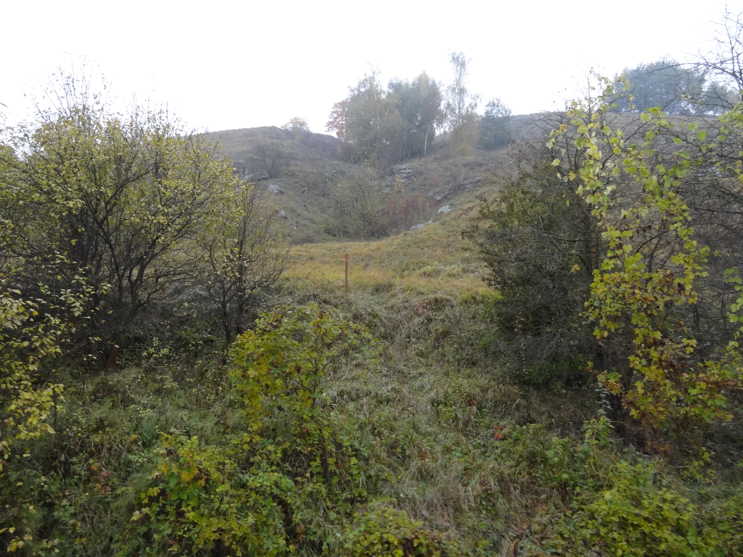
A slightly misty, overgrown landscape view of Na Dlouhé stráni with low hills, scattered trees, and shrubs under an overcast sky.
A view of the natural monument Na Dlouhé stráni, characterized by its rolling terrain and mixed scrub vegetation.

Na Dlouhé stráni history and protected-area timeline

Na Dlouhé stráni has no documented history as a long-standing traditional reserve; it is a relatively recent designation within the Czech system of protected areas. The site was formally declared a přírodní památka on 14 August 2012 by the Regional Authority of the Ústecký kraj. Its creation was motivated by the need to safeguard a Natura 2000 locality of European importance, reflecting the influence of EU-level habitat and species protection frameworks on Czech regional conservation decisions in the early 2010s.

Since then, the monument has continued to be administered by the same regional authority, with its protection focused on maintaining the habitat conditions that allow the site's key plant species to persist. There is no evidence from the available sources of significant boundary changes, redesignations, or political controversy around the site, and the available documentation presents the establishment of the monument as a focused conservation measure tied to recognised botanical and Natura 2000 values.

Na Dlouhé stráni landscape and geographic character

The landscape setting of Na Dlouhé stráni is defined by its position on a slope above the left bank of the Mšenský potok, the stream that flows through this part of the Litoměřice district. The protected zone sits at elevations ranging from approximately 196 to 244 metres above sea level, occupying a transition zone between the stream valley and the surrounding agricultural and lightly wooded countryside typical of lowland northern Bohemia.

The terrain is shaped as a warm, sun-exposed slope. Although there are no dramatic cliffs or large geological features associated with the site, the combination of slope orientation, elevation, and local soils supports a dry, open character that is unusual against the backdrop of otherwise intensively used farmland. This topographic openness is one of the principal reasons the slope has remained suitable for thermophilous grassland rather than being overrun by scrub or forest regeneration.

Visually, the area is comparatively modest: a stretch of meadow-like ground with grassy and herb-rich vegetation, viewed against the broader mosaic of fields, small woodlands, and the stream corridor. Its landscape identity lies less in spectacular landforms and more in its quiet, sheltered character and the way the slope opens toward the Mšenský potok valley below.

Na Dlouhé stráni ecosystems, habitats, and plant life

Ecologically, Na Dlouhé stráni represents a small but well-defined example of thermophilous, or heat-loving, dry grassland. Such habitats are associated with warm, well-drained slopes where summer temperatures are higher than in surrounding lowlands and where soils tend to be thinner and drier. In the context of north-central Bohemia, these conditions are not widespread, which makes patches like the one at Na Dlouhé stráni ecologically significant.

The site's ecological character is fundamentally open and herb-dominated. Rather than forest, scrubland, or wetland, the protected zone is centred on grassland communities that have evolved under historically low-intensity grazing or mowing pressures, with exposure to sunlight and a warm microclimate. This kind of habitat supports a characteristic set of flowering plants linked to steppe-like or dry-meadow environments, and it heavily determines the value of the protected area.

Because the site's Natura 2000 status is tied to species rather than to habitat type alone, the nature of Na Dlouhé stráni is best understood as a tight link between landform, microclimate, soils, and a specialised plant community. The site's continued ecological importance depends on maintaining the open, dry, sun-warmed character of the slope and preventing succession toward denser vegetation that would shade out the species the area was created to protect.

Na Dlouhé stráni conservation status and protection priorities

Na Dlouhé stráni is a conservation site with a tightly defined purpose. It is classified under the Czech system as a přírodní památka, a designation used for smaller protected areas of high natural value, and it is simultaneously recognised as part of the Natura 2000 network as a European Important Site. In IUCN terminology, it falls within Category IV, which denotes a habitat or species management area where conservation depends on active or ongoing land management rather than purely passive protection.

The conservation value of the site is essentially botanical. Its declaration was driven by the presence of several rare and regionally significant flowering plant species, including Anthericum liliago, Aster linosyris, and three Astragalus species (Astragalus austriacus, Astragalus danicus, and Astragalus onobrychis). Protecting these plants, along with the dry, warm grassland habitat that supports them, is the core objective of the monument.

Because the habitat is the product of a specific combination of slope, sun, soils, and a history of low-intensity land use, the long-term conservation interest of Na Dlouhé stráni depends on managing the slope against natural succession toward scrub and woodland. The Regional Authority of the Ústecký kraj, which both declared and administers the protected area, carries responsibility for maintaining conditions favourable to the species for which the site was designated. In this sense, the monument serves as a small but clear example of how botanically driven conservation is implemented at the regional level in the Czech Republic.

Top sights and standout views in Na Dlouhé stráni

Na Dlouhé stráni's strongest point of distinction is the concentration of rare thermophilous plant species on a small, sun-exposed slope above the Mšenský potok. Within a parcel of just over twelve hectares, the site hosts a plant community that would otherwise be increasingly difficult to find across north-central Bohemia, making it a textbook example of how minor topographic features can support disproportionate botanical value.

A second defining feature is the site's role within the Natura 2000 network. As a locally declared přírodní památka with European-level recognition, it connects regional Czech nature protection to broader EU biodiversity frameworks. Combined with its IUCN Category IV status and its recent establishment in 2012, this dual framing gives the reserve a clear and defensible conservation identity: small in scale, focused in purpose, and tightly linked to a specific habitat and species community.

Best time to visit Na Dlouhé stráni

The character of Na Dlouhé stráni is tightly tied to its dry, sun-exposed grassland, so the most rewarding period for a visit is late spring and summer, when the slope's flowering plants are above ground and visible. In the warmer months, the thermophilous character of the site, which is itself the reason for its protection, is most evident.

Autumn brings a quieter, more atmospheric mood, with mists sometimes settling over the stream valley below; this is the season when several documentary photographs of the site were taken. Outside the main flowering season the slope still preserves its open, herb-rich character, but visitors interested specifically in the botanical highlights will find late spring through high summer more rewarding. Winter visits are possible but visually subdued, with little floral activity and cooler conditions that obscure the warm-slope nature of the reserve.


Monthly climate preview

Long-term representative temperature and precipitation averages for Na Dlouhé stráni

Na Dlouhé stráni Climate Normals and Monthly Weather Statistics

Representative coordinates record measured monthly temperature ranges and precipitation levels across a multi-year climatology period for Na Dlouhé stráni. Examining complete twelve-month profiles clarifies annual thermal rhythms and moisture patterns without relying on live forecasts.
Annual mean9 °C
-2 °C20 °C
Jan-2°
Feb-1°
Mar
Apr
May14°
Jun18°
Jul20°
Aug19°
Sep14°
Oct
Nov
Dec-1°
Warmest month
July

19.8 °C

Coolest month
January

-2.3 °C

Wettest month
July

2.4 mm/day

Driest month
February

1 mm/day

Park location guide

Geography guide, regional context, and park location map for Na Dlouhé stráni

Na Dlouhé stráni park geography, regions, and map view in Czechia

Understand where Na Dlouhé stráni sits in Czechia through a broader geographic reading of the surrounding landscape, nearby location context, and its mapped position within the national park landscape.

How Na Dlouhé stráni fits into Czechia

Czech Republic is a landlocked Central European country with a population of approximately 10.9 million people. The nation was established as an independent state on January 1, 1993, following the dissolution of Czechoslovakia. Its capital and largest city is Prague, with other major urban centers including Brno, Ostrava, Plzeň, and Liberec.

Wider geography shaping Na Dlouhé stráni in Czechia

The Czech Republic is a landlocked country in Central Europe. It is bordered by Germany to the west, Austria to the south, Poland to the northeast, and Slovakia to the southeast. The landscape is predominantly hilly, with the territory covering 78,871 square kilometers.

Map view of Na Dlouhé stráni

Use this park location map to pinpoint Na Dlouhé stráni in Czechia, understand its exact geographic position, and read its mapped placement within the surrounding landscape more clearly.

Pigeon | © OpenStreetMap contributors

Location context for Na Dlouhé stráni

Ústecký kraj
Recorded earthquake history

Review Recorded Earthquake History and Seismic Data for Na Dlouhé stráni

Explore the historical catalogue of seismic events identified within the vicinity of the Na Dlouhé stráni natural monument. This MoriAtlas collection tracks recorded earthquake activity by date and magnitude, offering transparency into the regional seismic history of this protected Ústecký kraj landscape.

Na Dlouhé stráni Earthquake History

Catalogued events

12 events

Strongest magnitude

Magnitude 3.7

Most recent event

May 4, 2000

This history includes earthquakes recorded inside the park or within 50 km of its borders

Explore detailed imagery of the sun-exposed grassland slopes and botanical environments.

Na Dlouhé stráni Photos and Landscape Scenery: Visualizing the Protected Habitat

Visual records reveal the distinct topography and dry-grassland habitats of Na Dlouhé stráni above the Mšenský potok valley. Examining park photography provides a clearer understanding of the terrain and rare plant communities shaping this protected Czech landscape.

A slightly misty, overgrown landscape view of Na Dlouhé stráni with low hills, scattered trees, and shrubs under an overcast sky.

Park atlas

Compare surrounding regional landscapes and connected botanical reserves.

Explore Protected Areas and Other Parks Near Na Dlouhé Stráni

Browse protected areas and natural monuments located close to Na Dlouhé stráni in northern Bohemia. Extending your review reveals broader regional geography and allied grassland conservation sites across the surrounding countryside.
Natural monumentLitoměřice District
1.5 km away#1 closest

Northeast

Vrbka Natural Monument: Exploring Protected Limestone Habitats and Bohemian Lowland Geography

A rare botanical reserve in the Litoměřice District of the Czech Republic

Vrbka Natural Monument protects a significant 15.5-hectare expanse of warm limestone slopes and dry meadows. This geographic landmark serves as an essential repository for rare orchid species and diverse insect populations, functioning as a representative habitat patch within the intensively cultivated landscapes of the surrounding region.

Area
0.155 km²
Established
2013
IUCN
IV
Relief
Upland
A horizontal watercolor painting depicting a soft-focus landscape with light green trees and low rolling hills under a pale, warm-toned sky.
Protected landscapeLitoměřice District
About 4.3 km away#2 closest

Northwest

Dolní Poohří Nature Park: Protected Landscape and River Geography

A riparian corridor through the Litoměřice District

The landscape of Dolní Poohří Nature Park follows the irregular arc of the lower Ohře River across the Bohemian plain. Its narrow boundaries protect a functional floodplain ecosystem characterized by silted oxbows, gravel banks, and rare forest fragments. This atlas entry details the geographic features, protected status, and the interplay between the active river channel and the historic townscapes found along its banks.

Area
40 km²
Established
2001
Relief
Lowland
Climate
Temperate
Nature reserveUstecky Region
10 km away#3 closest

Northwest

Vrch Hazmburk Nature Reserve: Geographic Atlas and Protected Landscape Overview

Volcanic terrain and steppe ecosystems in the Ustecky Region

Vrch Hazmburk stands as a notable example of Neovolcanic geology, characterized by steep basalt slopes, frost-shattered cliffs, and a rich mosaic of dry grassland habitats. Located in the Ustecky Region, this protected site preserves a critical transition zone for thermophilic plants and rare invertebrates, offering a clear view of how geological movement and long-term land stability define the Bohemian lowland landscape.

Area
0.604 km²
Established
2011
IUCN
IV
Relief
Mountain
Natural monumentÚstecký kraj
11 km away#4 closest

West

V hlubokém Natural Monument: Protected Calcareous Landscapes and Terrain in Ústecký kraj

A study of rare sesleria grasslands and opuka slope geography

V hlubokém serves as a significant protected site in the Czech Republic, encompassing twenty hectares of hillside defined by soft calcareous opuka rock. This natural monument is recognized for its rare sesleria grasslands and thermophilic plant assemblages that contrast with the surrounding woodland. The protected area forms a critical link in the broader geography of the Débeř valley, offering a clear example of localized botanical diversity supported by unique alkaline substrate conditions.

Area
0.202 km²
Established
1947
IUCN
III
Relief
Upland
Natural monumentStředočeský kraj
16 km away#5 closest

Southeast

Veltrusy Natural Monument: Protected Woodland and Historic Park Geography in Středočeský kraj

English-style designed landscapes and floodplain ecological habitats.

Veltrusy Natural Monument is a protected area located on the right bank of the Vltava River, defined by its horseshoe-shaped layout and mosaic of oak-beech woodlands. The site represents a rare intersection of cultural heritage and nature conservation, preserving veteran trees that support significant invertebrate populations. Its geography consists of gently undulating floodplain terrain shaped by the Mlýnský potok, historic avenues, and managed meadows.

Area
2.555 km²
Established
2013
IUCN
III
Relief
Lowland
Watercolor painting of a pastoral landscape featuring rolling green hills, patches of trees, and a river flowing through the center.
Natural monumentStředočeský kraj
About 16 km away#6 closest

South

Slánská hora Natural Monument: Volcanic Geography and Protected Hilltop Terrain in Central Bohemia

Detailed geological mapping of a Tertiary volcanic outlier and historic monument

Slánská hora functions as a significant geological landmark where basaltic vent remnants meet centuries of human history. This natural monument offers a window into the volcanic processes of the region through exposed columnar basalt and rock fissures. The site serves as a vital protected area, balancing remnants of warm-loving steppe vegetation and deciduous forest with the legacy of former quarries and ancient archaeological strata atop the Slaný ridge.

Area
0.022 km²
Established
1998
IUCN
III
Relief
Mountain
A soft watercolor illustration of rolling green hills with distant mountain peaks under a light sky.
Natural monumentÚstecký kraj
17 km away#7 closest

North

Radobýl Natural Monument: Basalt Formations and Volcanic Geography in Ústecký kraj

A protected volcanic landmark with steppe ecosystems and ridge views.

Radobýl stands as a distinctive volcanic remnant in the Ústecký kraj, featuring profound columnar basalt jointing and frost-weathered cliffs. This protected natural monument shelters rare dry grassland habitats and rocky terrain, while offering expansive views across the Litoměřice basin and the surrounding Bohemian landscape.

Area
0.063 km²
Established
1966
IUCN
IV
Relief
Mountain
A horizontal watercolor illustration showing a soft-toned landscape with green trees in the foreground, rolling yellow-green fields in the midground, and faint mountains in the background.
Natural monumentStředočeský kraj
19 km away#8 closest

Southwest

Smradovna Natural Monument: Geography and Protected Habitats in Central Bohemia

A protected stream valley system within the Stredocesky kraj region.

Smradovna preserves a unique concentration of lowland habitats, including calcareous beech forests and rare alkaline fens. This protected natural monument, located near Bilichov, is defined by its characteristic travertine springs and continuous stream-corridor ecosystem. Gain insight into the regional geography and botanical significance of this tightly knit protected landscape through our structured mapping and data.

Area
1.556 km²
Established
2014
IUCN
IV
Relief
Upland

Common questions about visiting, size, designation, and location context for Na Dlouhé stráni

Na Dlouhé stráni FAQs for park facts, access, geography, and protected area context

Find quick answers about Na Dlouhé stráni, including protected-area facts, park geography, trail and visitor context, and how the park fits into its surrounding country and regional landscape.
MoriAtlas Explorer

Continue Your Protected Areas Search Across the Global Atlas

Deepen your exploration by continuing the structured search for national parks and protected areas worldwide. Utilize the comprehensive filtering capabilities to compare different conservation landscapes and refine your understanding of global park geography. Discover more about the distribution and characteristics of protected natural areas.

Global natural geography