
Mori Atlas logo
Natural monumentNa Opukách

Analyzing the geological character and botanical diversity of this unique South Bohemian grassland island

Na Opukách Natural Monument: A Distinct Calcareous Protected Landscape in Strakonice District

(Přírodní památka Na opukách)

Na Opukách stands as a vital natural monument within the Strakonice District, preserving a rare mosaic of calcareous dry grasslands and scattered woodland on opuka bedrock. This site serves as an essential ecological island, protecting plant communities and diverse wild rose populations that differ significantly from the surrounding forested terrain. Explore the topography of this distinct hill, which offers a compact look at the botanical richness shaped by unique sedimentary geology in the South Bohemian Region.

calcareous grasslanddry meadoworchidswild rosesopuka geologyscattered woodland mosaic
A graphic illustration of a mountain valley scene featuring steep cliff walls, pine trees in the foreground, a winding river, and soft clouds against a light pink sky.

Na Opukách

Natural monument

Park overview

Structured park overview, official facts, and landscape profile for Na Opukách

Na Opukách park facts, protected area profile, and essential visitor context

Review the core facts for Na Opukách, including designation, size, terrain, visitor scale, habitats, and operating context in one park-focused overview.

About Na Opukách

Na Opukách is a compact but ecologically distinctive nature reserve in the South Bohemian Region of the Czech Republic, near the town of Volyně in the Strakonice district. Its name, literally 'On the Opukas', refers to the soft, fine-grained calcareous sedimentary rock known locally as opuka, which forms the geological foundation of the protected hill. The nature monument occupies a moderately elevated ridge southeast of the village of Zechovice, and although small in size, its geological and botanical character gives it an importance that extends beyond its immediate surroundings.

The reserve has been protected since 1996, when it was declared a natural monument by the Strakonice District Office to safeguard what is officially recognized as a landscape of significant aesthetic value, with scattered greenery and fragments of non-forest plant communities. Ecologically, the critical feature of the site is that its substrate is calcareous rather than the siliceous bedrock typical of the broader region. Soils derived from opuka decalcify slowly and retain a higher pH, allowing the survival here of plant communities that belong more naturally to warmer lowland or hillside regions than to the cool and often acidic foothills where the hill actually sits.

Because of this unusual substrate, the hilltop at Na Opukách has escaped full conversion to conifer forest, which dominates much of the surrounding landscape. In its place, a mosaic has been preserved that combines isolated trees and shrubs with dry-meadow swards and exposed rocky patches. The result is a small, visually distinctive landscape island within a wider matrix of forest and farmland, and it is precisely this combination of geologically unusual substrate, surviving open habitat, and rich plant communities that justified the area's protection.

Today, the nature monument is valued both as a refuge for several regionally rare plant species and as a small but high-quality example of traditionally managed, semi-open countryside. Visitors encounter it primarily as a compact, walkable hill with open vistas, scattered trees, and seasonal wildflower displays rather than as a destination with extensive facilities. Its significance lies in the way a single hill's geology continues to shape and sustain biological diversity in an otherwise forest-dominated region.

Quick facts and research context for Na Opukách

Na Opukách is a Czech nature monument (přírodní památka) in the Strakonice district, declared in July 1996 by the former Strakonice District Office and now administered by the South Bohemian Regional Authority. The reserve lies on a low hill between the villages of Nišovice and Zechovice, east of Volyně, covering around thirty-five hectares at elevations between roughly 524 and 592 meters above sea level.

The hill is built on opuka, calcareous sedimentary rock that gives the site its name and its distinctive vegetation. Protection focuses on a landscape mosaic of scattered greenery and dry grassland fragments, supporting regionally rare orchids, ferns, vetches, and a notably rich wild rose flora. The site's IUCN management category is IV, indicating an area managed primarily for the conservation of specific species or habitats.

Protection and recognition

Examine documented protection scope and official conservation frameworks for Na Opukách.

Na Opukách Protection Status and Terrestrial Conservation Recognition

Terrestrial protection status and documented administrative records outline the conservation framework established for Na Opukách. Official recognition sources and management scope details provide structured context regarding the protected landscape.

Protection details

Protection scope
Terrestrial
Park context

Deeper park guide and search-rich context for Na Opukách

Na Opukách history, landscape, wildlife, and travel context

Explore Na Opukách through its history, landscape character, ecosystems, wildlife, conservation priorities, cultural context, and seasonal travel timing in a structured park guide built for atlas discovery and search intent.

Why Na Opukách stands out

Na Opukách is best known for its botanical richness on a small calcareous hilltop. The reserve protects a rare combination of dry grassland and scattered woodland over opuka bedrock, creating conditions for orchids such as the green-winged orchid and dark-red helleborine, the uncommon moonwort fern, and a particularly diverse assemblage of wild roses that includes the rare small-flowered rose. The site is also valued as a representative of a kind of habitat that has become increasingly scarce in the Czech countryside as traditional open landscapes have been reclaimed by forest or agriculture. Its mosaic of scattered trees, shrubs, and flowering meadow patches gives it both landscape and ecological significance, distinguishing it from the surrounding forest-dominated terrain of the Strakonice foothills.
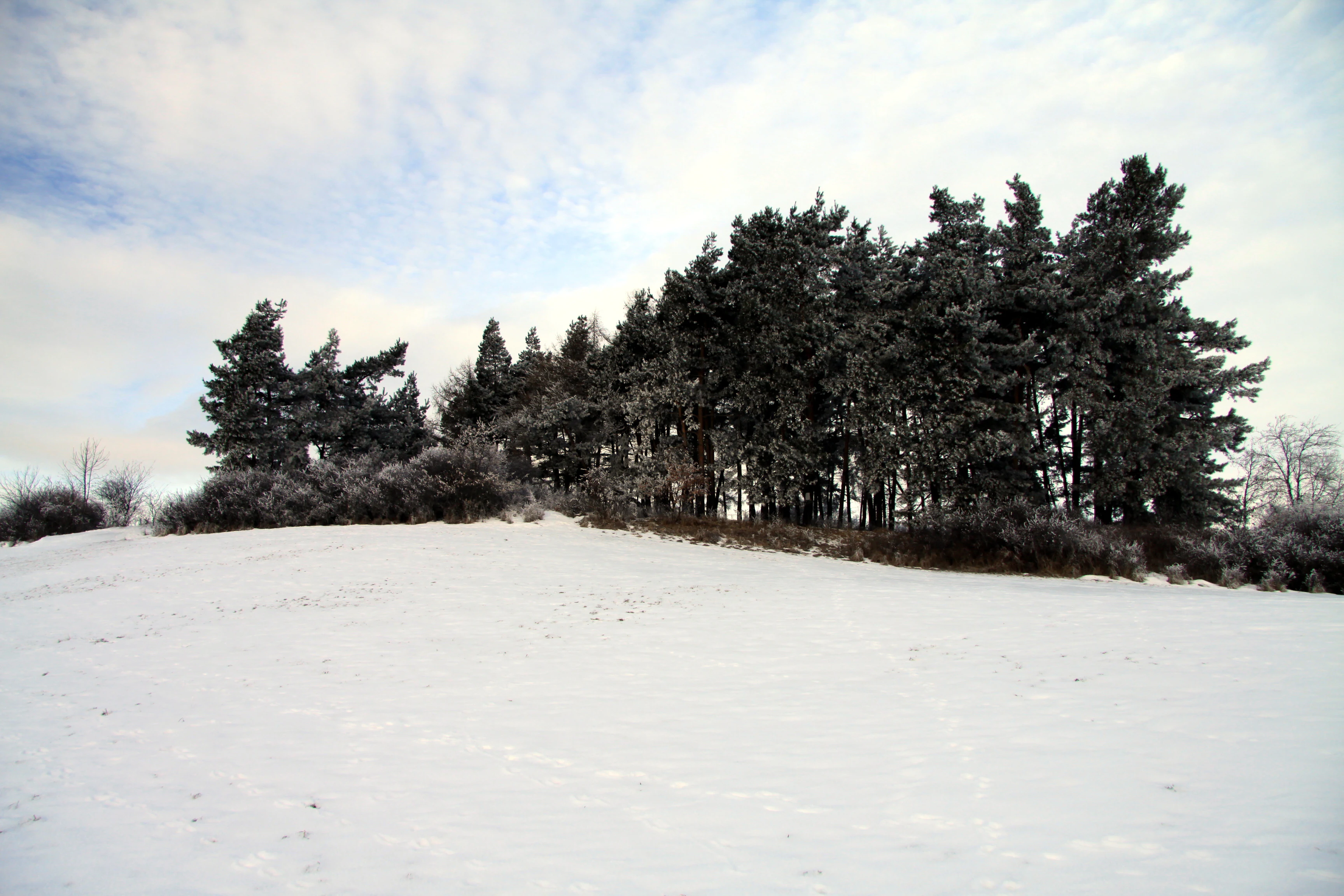
A snow-covered hill in the Czech Republic with a stand of evergreen trees.
A winter landscape at the Na Opukách natural monument.

Na Opukách history and protected-area timeline

The area that is now the nature monument Na Opukách was historically part of the open agricultural and pastoral landscape around the villages of Nišovice and Zechovice, west of the town of Volyně. While much of the surrounding low hills and uplands were gradually reclaimed by coniferous forest in the 20th century, the opuka hill retained its mixed character as a result of its geology, soils, and continued traditional land use, including grazing and haymaking that kept parts of the slope open.

Formal protection of the site dates to 1 July 1996, when the Strakonice District Office designated it as a přírodní památka, or natural monument. The reason for protection explicitly cited the landscape value of the area and the importance of its scattered greenery pattern and surviving non-forest plant communities, which together create a regionally distinctive mosaic within an otherwise heavily forested region.

Following administrative reforms in the Czech Republic, management responsibility for the site passed from the former Strakonice District Office to the South Bohemian Regional Authority. The reserve continues to be referenced in national inventories of protected areas, where it is identified by the central nature conservation database code 1826. The site is recognized internationally under IUCN management category IV, a category applied to areas primarily managed for the conservation of particular species or habitats.

Na Opukách landscape and geographic character

The landscape of Na Opukách is defined by a single compact hill that rises to a summit elevation near 592 meters above sea level, with lower slopes around the 524 meter contour. From the surrounding lowlands and forest, the hill appears as a moderately elevated, partly open landform with scattered trees, grassy openings, and exposed stony patches, giving it a visual character quite different from the dense conifer woodland of the wider Strakonice district.

Geologically, the hill is built on opuka, a soft, fine-grained calcareous sedimentary rock of marine origin that gives the reserve its name. This bedrock weathers into soils that retain calcium and provide moderately base-rich conditions, supporting plant communities that are not typical of the more acid, siliceous substrates of the broader Šumava foothills. Small rocky outcrops and stony shallow soils on the upper slopes add to the visual texture of the landscape, especially where sparse vegetation leaves bands of pale stone exposed among shrubs and meadow plants.

The hill is framed by the villages of Nišovice and Zechovice and lies along the right side of the main road corridor between Volyně and Čkyně. This positions the reserve at the edge of, but visually distinct from, both the surrounding settlements and the surrounding forested hills. The combination of open ridges, scattered greenery, and views out toward the valley landscape gives Na Opukách a defining identity as a small 'dry grassland island' in an otherwise wooded region.

Na Opukách ecosystems, habitats, and plant life

Ecologically, Na Opukách is distinguished by its calcareous grassland vegetation, which is otherwise rare in the predominantly acid foothill landscapes of southwestern Bohemia. The protected area functions as a refuge for species that depend on base-rich, nutrient-poor soils and a semi-open habitat structure, and this combination is increasingly uncommon in the modern Czech landscape.

The vegetation mosaic includes remnant fragments of dry meadow and pasture communities interspersed with solitary trees, low shrubs, and patches of bare or thinly vegetated rocky ground. These open and semi-open conditions are what allow light-demanding meadow species to persist, and they are a key reason the site has been able to maintain its botanical diversity despite its modest size.

The nature monument lies within a broader landscape context shaped historically by mixed agricultural use, and the surviving non-forest communities at Na Opukách represent a fragment of a more extensive habitat type that once existed across low hills in the region. The reserve is therefore valued not only for its present plant species but also as a representative of a vanishing local habitat class.

Na Opukách wildlife and species highlights

The principal wildlife interest at Na Opukách lies in its invertebrate fauna associated with the site's dry, flower-rich grasslands. Historically, the reserve supported local populations of rare butterflies tied to calcareous meadow habitats, including the large blue butterfly, whose presence was documented in the area but has not been confirmed there in recent surveys. Commoner related butterfly species, such as the chalkhill blue, continue to occur and are of conservation interest as part of a broader national pattern of decline among butterfly faunas in the Czech Republic.

Beyond butterflies, the mosaic structure of the reserve, with scattered trees, shrubs, and flowering meadows, supports typical insect communities of warm, open Czech low hills, including pollinator groups dependent on the diversity of flowering plants. The structure of the vegetation also offers shelter and foraging habitat for small passerine birds and small mammals characteristic of the agricultural and forest-edge mosaic of the Strakonice district.

The site's wildlife value is best understood as being closely tied to its botanical character: it is the survival of an open, flower-rich calcareous grassland mosaic that sustains the reserve's most distinctive insect and pollinator interest, rather than the presence of any single charismatic mammal or bird species.

Na Opukách conservation status and protection priorities

Na Opukách has been protected as a přírodní památka, a natural monument, since 1996. Its conservation rationale is explicitly framed around two linked values: the landscape value of the site's scattered greenery and mosaic structure, and the ecological value of its surviving fragments of non-forest plant communities on calcareous opuka bedrock.

In national nature conservation terms, the reserve is catalogued under central nature conservation database code 1826, and it is classified in the IUCN system as a category IV protected area, designated primarily for the conservation of particular species or habitats. After the restructuring of Czech regional administration, responsibility for its management was transferred from the original declaring authority, the Strakonice District Office, to the South Bohemian Regional Authority.

From a conservation biology perspective, the reserve's importance lies in the way it preserves a small-scale representation of a habitat type that is under strong pressure across the Czech Republic. Calcareous dry grasslands have been reduced nationally through agricultural intensification, abandonment followed by shrub encroachment, and afforestation, and surviving examples such as Na Opukách act as local refuges for specialist plant species and the invertebrate communities that depend on them. The site's continuing value therefore depends on maintaining the open and semi-open character of the hilltop, which depends in turn on appropriate management of vegetation succession.

Na Opukách cultural meaning and human context

The protected area lies within a small, long-settled agricultural landscape east of Volyně, a town that has historically served as a local market and service center for surrounding villages. The hill at Na Opukách has long been integrated into this rural fabric, with parts of its slopes traditionally used for grazing, hay cutting, and small-scale woodland management. This traditional land use is the reason the hilltop has retained its mosaic of open and wooded patches rather than being fully converted to dense forest, as much of the surrounding terrain was in the later 20th century.

The villages of Nišovice and Zechovice, whose cadastral areas adjoin the reserve, are part of a regional pattern of small Czech settlements whose landscapes have been shaped over generations by a mix of farming, meadow management, and forestry. The cultural identity of this part of the Strakonice district is tied to the gentle, partly wooded foothills around Volyně, and the protected hill is recognized locally both for its scenery and for the traditional grassland communities that distinguish it from the surrounding forests.

Top sights and standout views in Na Opukách

The protected hill at Na Opukách stands out for combining calcareous geology, surviving dry grassland habitat, and a notably rich flora in a compact, easily explored landscape. The site's mosaic of open meadow patches, scattered trees, and exposed opuka rock gives it a visual identity that contrasts with the surrounding forest-dominated terrain.

Among its most distinctive botanical features are diverse populations of wild roses, including the rare small-flowered rose, and a range of orchids and other meadow specialists that reflect the unusual base-rich soils. The reserve is also a surviving example of a more widespread but now scarce habitat type, calcareous dry grassland on opuka, that has disappeared from much of the wider region.

Best time to visit Na Opukách

The reserve is most rewarding to visit in late spring and early summer, when its dry grassland communities reach peak flowering and orchids such as the green-winged orchid are in bloom. This window, broadly from mid-May through June, is also the season when pollinators associated with the meadow flora are most active and when the contrast between the flowering swards and surrounding forest is most visually pronounced.

Late summer and early autumn visits are also worthwhile for a broader botanical perspective, including the wild rose assemblage for which the site is well known, while winter can highlight the open structure of the hill and its scattered trees against the surrounding forest. Because the site is valued for its plant communities rather than for visitor infrastructure, visits are best planned around these seasonal ecological highlights rather than around any specific facility-based timing.


Monthly climate preview

Long-term average temperature and precipitation patterns across the representative park coordinate

Na Opukách Climate Normals and Representative Monthly Temperature Rhythms

Representative coordinates record measured monthly temperature swings and precipitation rates spanning annual cycles at a 648 meter elevation. Detailed monthly climate normals reveal comprehensive data distributions across the entire twelve-month period.
Annual mean7 °C
-3 °C18 °C
Jan-3°
Feb-2°
Mar
Apr
May12°
Jun16°
Jul18°
Aug17°
Sep13°
Oct
Nov
Dec-2°
Warmest month
July

17.5 °C

Coolest month
January

-3.4 °C

Wettest month
June

3.3 mm/day

Driest month
April

1.6 mm/day

Park location guide

Geography guide, regional context, and park location map for Na Opukách

Na Opukách park geography, regions, and map view in Czechia

Understand where Na Opukách sits in Czechia through a broader geographic reading of the surrounding landscape, nearby location context, and its mapped position within the national park landscape.

How Na Opukách fits into Czechia

Czech Republic is a landlocked Central European country with a population of approximately 10.9 million people. The nation was established as an independent state on January 1, 1993, following the dissolution of Czechoslovakia. Its capital and largest city is Prague, with other major urban centers including Brno, Ostrava, Plzeň, and Liberec.

Wider geography shaping Na Opukách in Czechia

The Czech Republic is a landlocked country in Central Europe. It is bordered by Germany to the west, Austria to the south, Poland to the northeast, and Slovakia to the southeast. The landscape is predominantly hilly, with the territory covering 78,871 square kilometers.

Map view of Na Opukách

Use this park location map to pinpoint Na Opukách in Czechia, understand its exact geographic position, and read its mapped placement within the surrounding landscape more clearly.

Pigeon | © OpenStreetMap contributors

Location context for Na Opukách

Strakonice District

Explore detailed imagery of calcareous dry grasslands, limestone terrain, and rare botanical habitats.

Na Opukách Photos and Landscape Scenery: Visualizing Protected Habitats

Examine high-resolution park imagery to understand the distinct calcareous terrain, exposed rock outcrops, and dry grassland habitats of Na Opukách. Visual records reveal the rare botanical mosaic, scattered woodland patches, and open ridge morphology defining this protected South Bohemian landscape.

A snow-covered hill in the Czech Republic with a stand of evergreen trees.

Park atlas

Compare adjacent protected landscapes and regional calcareous habitats

Exploring Other Parks Near Na Opukách in the Surrounding Bohemian Region

Browse nearby national parks and protected areas sharing the wider geography of the Bohemian foothills. Comparing adjacent reserves reveals how local geology and elevation shape surrounding plant communities.
A watercolor painting of soft green rolling hills and small clusters of pine trees against a light sunset sky.
Natural monumentJihočeský kraj
About 14 km away#1 closest

North

Ryšovy Natural Monument and Botanical Protected Area in Jihočeský kraj

Exploring limestone woodland terrain and rare floral habitats

Ryšovy is a notable natural monument in the Czech Republic, defined by its characteristic limestone bedrock and the resulting diverse herb layer. This protected area creates a significant botanical stronghold within the wider landscape of the Jihočeský kraj, featuring a mosaic of woodland patches and sun-exposed clearings that support protected orchids and other rare thermophilous plant species.

Area
0.35 km²
Established
1990
IUCN
IV
Relief
Upland
Natural monumentJihočeský kraj
About 15 km away#2 closest

South

V polích Natural Monument: Meadow Conservation in the Jihočeský kraj Region

A protected orchid-rich grassland above the Blanice river valley

V polích is a designated natural monument in the Czech Republic known for its managed hay-meadow habitats. This site plays a vital role in regional conservation by maintaining a rare, species-rich landscape that supports native orchid populations on a sunny, south-east facing slope in the Prachatice District.

Area
0.017 km²
Established
1992
IUCN
IV
Relief
Upland
Watercolor painting of a grassy meadow bordered by a forest line with soft green and muted earth tones.
Nature reserveJihočeský kraj
About 19 km away#3 closest

West

Rašeliniště u Martinala: A Protected Nature Reserve in the Jihočeský kraj Foothills

Mapping transitional bog ecosystems and submontane habitats

Located in the Šumava foothills, Rašeliniště u Martinala is a protected nature reserve defined by its dual-parcel structure of peat-forming wetlands and juniper-rich dry grasslands. This site acts as a key ecological node, supporting a high density of protected species within the Jáchymovský potok drainage basin and representing a refined example of south Bohemian submontane landscape character.

Area
0.095 km²
Established
2011
IUCN
IV
Relief
Upland
Natural monumentJihočeský kraj
About 20 km away#4 closest

Northeast

Velký Potočný: Protected Natural Monument and Wetland Geography in the South Bohemian Region

An essential migratory node and rare plant refuge in the Czech landscape.

Velký Potočný represents a unique intersection of traditional fishpond management and modern biodiversity conservation in Jihočeský kraj. This natural monument supports exceptional shoreline vegetation, including rare species like Cyperus fuscus, and serves as a critical breeding and stopover ground for diverse waterbirds. Its shallow basin geography and hydrologic connection to the Otava River make it a vital point of interest for understanding the ecological function of South Bohemia's inland wetland network.

Area
0.39 km²
Established
1986
IUCN
IV
Relief
Lowland
A watercolor painting showing a panoramic view of a marshy wetland area with sparse bare trees, grassy mounds, and rolling hills in the background.
Natural monumentJihočeský kraj
About 20 km away#5 closest

Northeast

Ražický rybník Natural Monument and Protected Wetland Geography in South Bohemia

Protected pond ecosystems and riparian terrain maps

Ražický rybník is a protected natural monument located in the Písek District of the Czech Republic, encompassing a shallow fishpond and surrounding meadows. This site serves as an essential breeding ground for waterbirds and provides a detailed look at the wetland mosaic characteristic of the Otava river lowlands. The area highlights the intersection of long-standing conservation efforts and habitat restoration through its diverse aquatic microhabitats.

Area
0.291 km²
Established
1986
IUCN
IV
Relief
Lowland
Watercolor illustration of a river flowing through a forested landscape with rolling hills in the background
National parkSouth Bohemian Region
About 21 km away#6 closest

Southwest

Šumava National Park: Czech Republic's Premier Forested National Park and Protected Landscape

Explore the unique glacial lakes, peat bogs, and regional geography.

Šumava National Park, situated in the South Bohemian Region of the Czech Republic, is the nation's largest protected area and a vital component of Central Europe's forest ecosystems. This entry details its expansive terrain, highlighting the significant peat bog complexes and ancient glacial lakes that define its unique landscape. Discover the park's geographic context, mapped boundaries, and its importance as a protected natural asset within the broader regional atlas.

Area
680.64 km²
Established
1991
IUCN
II
Visitors
2M annual
A wide watercolor illustration showing a pale landscape with a stream, rocky banks, distant hills, and pink and green grass in the foreground.
Natural monumentJihočeský kraj
About 22 km away#7 closest

Northeast

Michovka Natural Monument: Protected Limestone Landscapes in the South Bohemian Region

A diverse protected area in the Písek District of the Czech Republic.

Located on the outskirts of Brloh u Drhovle, Michovka encompasses a distinctive mix of fishponds, limestone-rich rocky slopes, and rare short-sedge vegetation. This compact protected area provides a vital habitat for endangered wildlife and represents an important segment of the South Bohemian natural terrain.

Area
0.025 km²
Established
1985
IUCN
IV
Relief
Lowland
A horizontal watercolor illustration depicting soft, rolling hills in shades of green, yellow, and light pink with small clusters of trees.
Nature reservePlzeňský kraj
About 23 km away#8 closest

Northwest

Prácheň Nature Reserve: Protected Broadleaf Woodlands and Historic Castle Remains

An atlas view of Bohemian forest geography and heritage landscapes

Prácheň Nature Reserve protects a compact block of warm-loving deciduous woodland set atop a hilltop in the Plzeňský kraj region. The area integrates significant natural habitats with cultural heritage, encompassing an early medieval hillfort and castle ruins. This unique blend of forest ecology and Bohemian historical geography offers a distinct perspective on protected areas within the southwestern Czech landscape.

Area
0.283 km²
Established
1953
IUCN
IV
Relief
Upland

Common questions about visiting, size, designation, and location context for Na Opukách

Na Opukách FAQs for park facts, access, geography, and protected area context

Find quick answers about Na Opukách, including protected-area facts, park geography, trail and visitor context, and how the park fits into its surrounding country and regional landscape.
MoriAtlas Explorer

Continue Your Protected Areas Search Across the Global Atlas

Deepen your exploration by continuing the structured search for national parks and protected areas worldwide. Utilize the comprehensive filtering capabilities to compare different conservation landscapes and refine your understanding of global park geography. Discover more about the distribution and characteristics of protected natural areas.

Global natural geography