
Mori Atlas logo
Natural monumentNa Vápenici

Mapping the geological features and rare calcareous habitats of this protected natural site

Na Vápenici Natural Monument: A Distinctive Limestone Outcrop within the Liberec Region Landscape

(Přírodní památka Na Vápenici)

Na Vápenici serves as a vital protected natural monument in the Liberec Region, defined by its rare limestone outcrop that contrasts sharply with the surrounding terrain. This site sustains a microhabitat of calcareous and herb-rich beech forest, providing an essential sanctuary for endangered flora and significant paleontological deposits. By analyzing its specific geological and ecological boundaries, observers gain insight into how localized natural formations influence regional biodiversity within the broader protected landscape.

natural monumentlimestone outcropcalcareous beech forestČeský rájLiberec Regionspecies management area
A stylized illustration showing a moss-covered boulder in a dense forest with a distant waterfall and soft sunlight in the background.

Na Vápenici

Natural monument

Park overview

Structured park overview, official facts, and landscape profile for Na Vápenici

Na Vápenici park facts, protected area profile, and essential visitor context

Review the core facts for Na Vápenici, including designation, size, terrain, visitor scale, habitats, and operating context in one park-focused overview.

About Na Vápenici

Na Vápenici is a small but ecologically distinctive natural monument located in the northern part of the Czech Republic, inside the Český ráj Protected Landscape Area. The site lies between the town of Železný Brod and the village of Koberovy, in the district of Jablonec nad Nisou, and takes its name from a modest limestone ridge or outcrop, 'vápenice,' that interrupts an otherwise more acidic local geology. This calcareous foundation is the defining feature of the protected area, shaping both its scenery and its biological character.

The monument was declared in 2008 by the Administration of the CHKO Český ráj and is administered by the Czech Nature Conservation Agency through its Liberec regional office. It falls under IUCN management category IV, recognizing it primarily as a habitat for a specific species of conservation concern. Although its footprint is very small, just a few hectares in area and confined to a narrow elevation band, the site has been identified as regionally important for several reasons that combine into a coherent conservation story.

What makes Na Vápenici scientifically and ecologically interesting is the contrast between the limestone outcrop and the surrounding landscape. Where the bedrock is calcareous, the resulting soils support a different forest community than is typical for the region, favoring beechwoods enriched with herbaceous understory plants adapted to lime-rich substrates. This habitat mosaic allows species that are otherwise rare or absent from the wider Český ráj area to persist here. The monument is also recognized for its paleontological value, with stratigraphically significant fossil content embedded in the limestone, linking the site to deeper geological history in addition to its present-day ecological role.

Quick facts and research context for Na Vápenici

Na Vápenici is a Czech přírodní památka (natural monument) classified under IUCN Category IV as a Species Management Area. It lies in the Liberecký kraj, in the okres Jablonec nad Nisou, within the cadastral territory of Vrát, between Železný Brod and Koberovy. The site sits inside the larger Český ráj Protected Landscape Area and is administered by AOPK ČR through its Liberec regional office. Declared on 16 April 2008 by the Administration of the Český ráj PLA, the monument covers a compact footprint defined by a limestone outcrop between roughly 325 and 415 meters in elevation.

Protection and recognition

Terrestrial conservation framework and international recognition data

Na Vápenici Protection Status and Documented Conservation Scope

Terrestrial protection status and designation details define the conservation framework established for Na Vápenici. Structured records outline the documented management scope and official recognition parameters associated with the protected area.

Protection details

Protection scope
Terrestrial
Transboundary protection
No
Park context

Deeper park guide and search-rich context for Na Vápenici

Na Vápenici history, landscape, wildlife, and travel context

Explore Na Vápenici through its history, landscape character, ecosystems, wildlife, conservation priorities, cultural context, and seasonal travel timing in a structured park guide built for atlas discovery and search intent.

Why Na Vápenici stands out

Na Vápenici is best known for its isolated limestone outcrop that supports calcareous and herb-rich beech forests unusual for the surrounding region. It is also notable for hosting what appears to be the only known population of a critically endangered fern in the area. In addition, the outcrop contains stratigraphically significant paleontological material, making it valuable both ecologically and geologically within the broader Český ráj Protected Landscape Area.
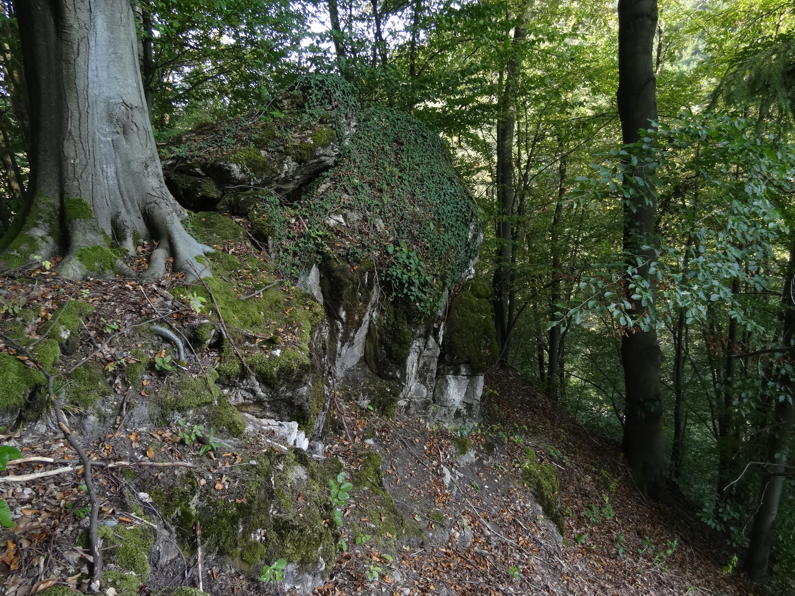
A large moss-covered limestone rock formation sits on a forested hillside at Na Vápenici, surrounded by mature trees.
A mossy rock outcrop within the beech forest of Na Vápenici nature monument.

Na Vápenici history and protected-area timeline

Na Vápenici was formally designated as a přírodní památka, a natural monument under Czech nature conservation law, on 16 April 2008. The protection was proclaimed by the Administration of the CHKO Český ráj, the authority responsible for managing the surrounding Protected Landscape Area, reflecting how the site's significance was understood in the context of the broader regional conservation framework.

The decision to protect the area was driven by the discovery that its small limestone outcrop hosted regionally important calcareous beech forest stands, a single known population of a critically endangered fern, and paleontologically valuable rock exposures. By placing the site under official protection, authorities aimed to preserve both the living forest community and the geological record associated with the outcrop. Since its establishment, the site has remained under the stewardship of the Czech Nature Conservation Agency's Liberec regional office.

Na Vápenici landscape and geographic character

The defining landscape feature of Na Vápenici is a small limestone ostroh, or rocky outcrop, that rises from the surrounding terrain of the Český ráj region. This compact elevation change is enough to create a clearly different surface character within a relatively short distance, with the calcareous rock contrasting with the broader geological setting of the area.

The outcrop sits within a narrow elevation band roughly between 325 and 415 meters above sea level, perched on slopes near the settlement of Propastný between Železný Brod and Koberovy. Although the relief is subtle by regional standards, the limestone structure is distinct enough to influence soil chemistry, drainage, and exposure, producing microhabitats that differ sharply from the surrounding forest land. The combination of rocky outcrops, thin calcareous soils, and adjacent woodland gives the monument a layered visual identity centered on this geological anomaly within the protected landscape.

Na Vápenici ecosystems, habitats, and plant life

Ecologically, Na Vápenici is defined above all by its calcareous substrate. The limestone bedrock supports stands of vápnomilné a květnaté bučiny, calciphilous and floristically rich beech forests, that are regionally significant within the Český ráj Protected Landscape Area. These forest stands are characterized by beech as a dominant canopy species, combined with a more diverse herbaceous understory than is typical on the more acidic substrates that dominate the surrounding region.

The unusual soil chemistry created by the limestone allows plants adapted to lime-rich conditions to coexist alongside species more typical of the broader Bohemian forest landscape. This ecological contrast makes the site function as a small refuge for calcareous forest flora within an extensive protected landscape otherwise shaped by different geological conditions. The site is also recognized for hosting what is described as the only known population of a critically endangered fern species in the area, adding a rare and highly localized element to its natural value. The combination of rare forest type, unusual substrate, and isolated plant population gives the monument a focused but ecologically meaningful character.

Na Vápenici wildlife and species highlights

Because the available sources for Na Vápenici emphasize its forest vegetation and a single critically endangered fern population, the wildlife profile of this small monument is closely tied to its plant communities rather than to large or conspicuous fauna. The calcareous beech forests provide habitat for forest-floor invertebrates and other species associated with mature deciduous woodland on lime-rich soils, and the fern population itself represents a rare and protected element of the local biota.

The steep, rocky outcrop and its mosaic of exposed limestone, leaf litter, and herb-rich undergrowth create microhabitats that contrast with the surrounding forest and are likely to support a distinct community of small forest species. However, the public record available for this site concentrates on floristic and paleontological significance rather than on detailed faunal inventories, so broader wildlife claims are not well supported.

Na Vápenici conservation status and protection priorities

Na Vápenici is protected primarily because its small limestone outcrop supports a combination of features that are individually rare and collectively unique within the region. The calcareous and herb-rich beech forests are considered regionally significant, the outcrop hosts the only known local population of a critically endangered fern, and the rock exposures contain stratigraphically important paleontological material. Together these qualities justify the site's designation as a přírodní památka under Czech law and its classification in IUCN Category IV, which recognizes areas managed primarily for particular species or habitats.

The monument is administered by the Czech Nature Conservation Agency through its Liberec regional office and falls within the larger Český ráj Protected Landscape Area, which provides additional landscape-level protection around the small core site. Conservation management therefore operates at two scales, with the protected landscape area providing broader buffering and the natural monument providing site-specific safeguards for the calcareous forests, the rare fern, and the geologically important outcrop.

Top sights and standout views in Na Vápenici

The standout qualities of Na Vápenici are concentrated in a remarkably small area. A single limestone outcrop supports rare calcareous beech forest, hosts a critically endangered fern found nowhere else nearby, and exposes paleontologically significant rock. Together these features make the site a compact but unusually rich node of natural heritage within the Český ráj Protected Landscape Area.

Best time to visit Na Vápenici

Na Vápenici is a small protected natural monument rather than a developed visitor destination, and seasonal guidance is best framed around the character of the forest rather than tourism infrastructure. Late spring and early summer are particularly worthwhile for observing the herb-rich beech understory in bloom, while autumn highlights the color of the beech canopy against the pale limestone outcrop. In winter, the exposed rock and bare forest structure can make the underlying geology easier to see, though access may be affected by weather and the terrain typical of hillside forest in the Bohemian uplands.

Monthly climate preview

Long-term monthly temperature ranges and precipitation patterns for Na Vápenici

Na Vápenici Climate Normals, Annual Temperature and Precipitation Rhythm

Representative coordinate measurements reveal the multi-year monthly temperature and precipitation rhythm across Na Vápenici from 1991 to 2020. Examining the complete twelve-month climatology profile provides deeper insight into long-term thermal shifts and moisture distribution.
Annual mean8 °C
-3 °C19 °C
Jan-3°
Feb-2°
Mar
Apr
May13°
Jun17°
Jul19°
Aug18°
Sep13°
Oct
Nov
Dec-2°
Warmest month
July

18.7 °C

Coolest month
January

-3.1 °C

Wettest month
July

2.9 mm/day

Driest month
April

1.3 mm/day

Park location guide

Geography guide, regional context, and park location map for Na Vápenici

Na Vápenici park geography, regions, and map view in Czechia

Understand where Na Vápenici sits in Czechia through a broader geographic reading of the surrounding landscape, nearby location context, and its mapped position within the national park landscape.

How Na Vápenici fits into Czechia

Czech Republic is a landlocked Central European country with a population of approximately 10.9 million people. The nation was established as an independent state on January 1, 1993, following the dissolution of Czechoslovakia. Its capital and largest city is Prague, with other major urban centers including Brno, Ostrava, Plzeň, and Liberec.

Wider geography shaping Na Vápenici in Czechia

The Czech Republic is a landlocked country in Central Europe. It is bordered by Germany to the west, Austria to the south, Poland to the northeast, and Slovakia to the southeast. The landscape is predominantly hilly, with the territory covering 78,871 square kilometers.

Map view of Na Vápenici

Use this park location map to pinpoint Na Vápenici in Czechia, understand its exact geographic position, and read its mapped placement within the surrounding landscape more clearly.

Pigeon | © OpenStreetMap contributors

Location context for Na Vápenici

Liberec Region

Visual exploration of rare beech forests, rocky terrain, and protected natural monument habitats.

Na Vápenici Landscape Photos and Scenery: Exploring the Limestone Outcrop

Photographic documentation reveals the distinct limestone geology and rare forest habitats defining Na Vápenici. Visual records of the rocky outcrop and surrounding terrain provide essential context for understanding regional protected landscapes.

A large moss-covered limestone rock formation sits on a forested hillside at Na Vápenici, surrounded by mature trees.

Park atlas

Compare surrounding natural monuments and connected protected landscapes in the Liberec Region.

Parks Near Na Vápenici and Related Protected Areas in the Region

Browsing other parks near Na Vápenici reveals a wider network of protected natural monuments and specialized forest reserves across the surrounding terrain. Comparing these nearby geological sites provides essential regional context for the unique calcareous habitats found throughout the Český ráj landscape.
Natural monumentSemily District
About 12 km away#1 closest

Southwest

Vústra Natural Monument: Mapping the Protected Wetland Landscapes of the Semily District

A concentrated botanical and geological sanctuary in the Bohemian Paradise

Vústra is a highly localized natural monument in the Semily District that preserves a vital wetland complex including a pond and calcareous fen. Surrounded by characteristic sandstone rock towers and alder-spruce forests, the site serves as a vital ecological anchor within the wider Bohemian landscape. This detail page traces the specific boundaries and topographical features that define this protected monument.

Area
0.023 km²
Established
1996
IUCN
IV
Relief
Lowland
Watercolor painting showing green forests, a valley, and distant mountains under a soft sky
National parkLiberec Region
About 13 km away#2 closest

East

Krkonoše National Park: Central European Alpine Protected Area and Map Context

Discover glacial landforms and unique ecosystems in the Giant Mountains.

Krkonoše National Park, situated in the Liberec Region, is a premier example of a protected alpine landscape in Central Europe. This page facilitates exploration of its significant glacial geography, including distinct cirques, rockfields, and valleys, providing vital context for understanding its protected area status. Engage with the mapped terrain and discover the unique ecological features that make this national park a cornerstone of conservation and geographic study within the Czech Republic.

Area
363.52 km²
Established
1963
IUCN
II
Visitors
12.1M annual
A watercolor illustration of rolling hills with a treeline and meadow, featuring soft green and orange tones on a white background.
Natural monumentKrálovéhradecký kraj
About 13 km away#3 closest

South

Na víně Natural Monument: Protected Opoka Slopes and Botanical Geography in Královéhradecký kraj

Geographic atlas and ecological profile of a protected Czech natural monument

Na víně represents an essential, small-scale protected landscape in the Jičín District of Královéhradecký kraj. This site is defined by its characteristic calcareous opoka hill slopes and its role as a botanical refuge for rare, thermophilous species. By mapping the interaction between the underlying Cretaceous geology and the surviving dry grassland communities, this analysis highlights the importance of localized conservation within the broader Bohemian Cretaceous Basin.

Area
0.055 km²
Established
1990
IUCN
IV
Relief
Upland
Watercolor painting showing a river, grassy banks, scattered trees, and distant hills
Protected landscapeCzechia
About 14 km away#4 closest

South

Bohemian Paradise Protected Landscape: Discover Czech Republic's Sandstone Geology and Park Boundaries

Mapped sandstone formations and historic regional geography.

Delve into Bohemian Paradise, a protected landscape in the Czech Republic celebrated for its dramatic sandstone rock formations and ancient castles. This detailed entry provides context on its unique geological character, the extent of its protected boundaries, and its significant position within the regional geography. Explore the mapped terrain and understand the atlas value of this historic protected area.

Area
181.17 km²
Established
1955
IUCN
V
Relief
Upland
Natural monumentKrálovéhradecký kraj
About 15 km away#5 closest

Southwest

Meziluží Natural Monument: Mapping Protected Landscape Geography in Královéhradecký Kraj

A study of sandstone terrain and historic conservation within the Bohemian Paradise

Meziluží provides a detailed look at the geography of small-scale protected sites in the Czech Republic. By analyzing its steep sandstone slopes and traditional orchard-pasture land use, users gain a clearer understanding of the complex relationship between regional geology and botanical conservation history in the Bohemian Paradise area.

Area
0.015 km²
Established
1997
Relief
Upland
Scope
Terrestrial
Natural monumentStředočeský kraj
About 16 km away#6 closest

Southwest

V Dubech Natural Monument: Protected Wetland Landscapes and Geography in Czech Republic

A compact wetland mosaic in the Středočeský kraj region

V Dubech is a protected natural monument situated at the base of the Příhrazské skály sandstone formations in the Czech Republic. This site preserves a valuable wetland mosaic, including base-rich peat meadows and alder woodlands that support rare species. The park provides an essential look at the localized, water-dominated geography within the broader context of the Bohemian Paradise protected landscape.

Area
0.047 km²
Established
1998
IUCN
III
Relief
Lowland
Watercolor illustration of sandstone rock towers and coniferous trees in a landscape setting with a light color palette.
Nature reserveKrálovéhradecký kraj
About 19 km away#7 closest

South

Prachovské skály Nature Reserve: Geologic Atlas of Bohemian Sandstone Formations

Mapped sandstone towers and protected forest terrain in Královéhradecký kraj

Prachovské skály consists of a concentrated sandstone massif characterized by towering pinnacles and labyrinthine gorges. This nature reserve serves as a prime example of sedimentary erosion in the Bohemian Paradise region, offering a distinct landscape profile that stands in sharp contrast to the surrounding agricultural plains of the Czech Republic.

Area
2.624 km²
Established
1928
IUCN
IV
Visitors
300K annual
Natural monumentCentral Bohemian Region
About 20 km away#8 closest

Southwest

Vrch Káčov Natural Monument: Mapped Geological Features in Central Bohemia

Volcanic rock formations and regional terrain context

Vrch Káčov is a designated natural monument preserving a unique volcanic hill and rock suk in the Central Bohemian Region. Its landscape is defined by contact metamorphism and porcelanite formations, offering a concentrated look at the geological evolution of the Jičínská pahorkatina hill country. The site provides a valuable reference for analyzing protected Bohemian terrain and its surrounding geographic characteristics.

Area
0.019 km²
Established
1953
IUCN
III
Relief
Upland

Common questions about visiting, size, designation, and location context for Na Vápenici

Na Vápenici FAQs for park facts, access, geography, and protected area context

Find quick answers about Na Vápenici, including protected-area facts, park geography, trail and visitor context, and how the park fits into its surrounding country and regional landscape.
MoriAtlas Explorer

Continue Your Protected Areas Search Across the Global Atlas

Deepen your exploration by continuing the structured search for national parks and protected areas worldwide. Utilize the comprehensive filtering capabilities to compare different conservation landscapes and refine your understanding of global park geography. Discover more about the distribution and characteristics of protected natural areas.

Global natural geography