
Mori Atlas logo
Nature reserveNachtweid von Dauernheim

A rare saline grassland and essential wetland habitat network in the eastern Wetterau region

Nachtweid von Dauernheim Nature Reserve: Mapped Protected Landscapes and Regional Geography

(Naturschutzgebiet Nachtweid von Dauernheim)

Nachtweid von Dauernheim serves as a critical nature reserve in the Hessen region, protecting 79 hectares of wet meadows and sedge marshes. Its distinctive character stems from mineral-rich groundwater that fosters rare halophilic plant communities and supports the most significant rail bird population in the state. Positioned within the floodplain network near the Nidda river, this protected area functions as a vital ecological corridor in the broader Wetterau landscape.

grassland reservesaline meadowwet meadowsedge marshrail habitatbirdwatching
A stylized flat vector illustration of a valley with a winding river, surrounded by mountains and pine trees, rendered in a warm, pastel color palette.

Nachtweid von Dauernheim

Nature reserve

Park overview

Structured park overview, official facts, and landscape profile for Nachtweid von Dauernheim

Nachtweid von Dauernheim park facts, protected area profile, and essential visitor context

Review the core facts for Nachtweid von Dauernheim, including designation, size, terrain, visitor scale, habitats, and operating context in one park-focused overview.

About Nachtweid von Dauernheim

Nachtweid von Dauernheim lies in the gently rolling agricultural landscape of the eastern Wetterau, between the villages of Dauernheim and Staden, southwest of the larger Nidda river floodplain. Covering approximately 78.9 hectares, the reserve was formally designated as a nature area in 1978 and has remained under protection ever since as part of Hesse's system of formally recognized Naturschutzgebiete. Although modest in size, it occupies an ecologically outsized role due to the unusual groundwater chemistry that rises through its soils.

The reserve's core identity is shaped by its open, largely treeless character. Rather than forest, Nachtweid von Dauernheim is a grassland-dominated landscape, with wet meadows, sedge marsh communities, and stretches of low-lying marshy ground. These habitats are maintained through traditional land management practices and have long supported a specialized bird community, especially rails and other shy marshland species that require exactly this combination of dense vegetation, shallow water, and minimal disturbance.

Beyond its ornithological importance, Nachtweid von Dauernheim is a reference site for saline meadow research and conservation in Hesse. The mineral-rich springs rising in the area create conditions favorable for halotolerant and halophilic plants, many of which are uncommon or absent elsewhere in the region. This rare combination of saline flora and rail-rich marsh makes the reserve a standout site in the Wetteraukreis, even when compared to the larger landscape protection area it borders.

Quick facts and research context for Nachtweid von Dauernheim

Nachtweid von Dauernheim is a designated nature reserve ("Naturschutzgebiet") in the Wetterau district of Hesse, first protected in 1978 under the official identifier 1440005. The reserve covers about 78.9 hectares of grassland and lies southwest of Dauernheim and northwest of Staden, along the edge of the Nidda river floodplain. It is connected to the larger Auenverbund Wetterau landscape protection area and is recognized as the state's leading habitat for rail birds and saline-influenced plant communities.

Protection and recognition

Examine documented protection records and official designation facts for Nachtweid von Dauernheim.

Nachtweid von Dauernheim Protection Status and Official International Recognition Data

Nachtweid von Dauernheim brings together verified protection status records, designation history, and management scope within a structured framework. Consult official conservation data and baseline protection facts for thorough geographic research.

Protection details

WDPA ID
82200
Park context

Deeper park guide and search-rich context for Nachtweid von Dauernheim

Nachtweid von Dauernheim history, landscape, wildlife, and travel context

Explore Nachtweid von Dauernheim through its history, landscape character, ecosystems, wildlife, conservation priorities, cultural context, and seasonal travel timing in a structured park guide built for atlas discovery and search intent.

Why Nachtweid von Dauernheim stands out

Nachtweid von Dauernheim is best known for two strongly interconnected ecological features. First, it is considered the most significant rail bird biotope in all of Hesse, supporting notable populations of these elusive wetland birds in terms of both species diversity and sheer numbers. Second, the reserve is remarkable for its saline grassland character. Mineral-rich water rises through the rooted soil horizons, producing locally halophilic and halotolerant plant communities that are otherwise rare in the region. Six of sixteen Red List plant species recorded in the area are tied directly to this small but ecologically distinctive saline habitat, making Nachtweid von Dauernheim a key reference site for saline meadow conservation in central Germany.
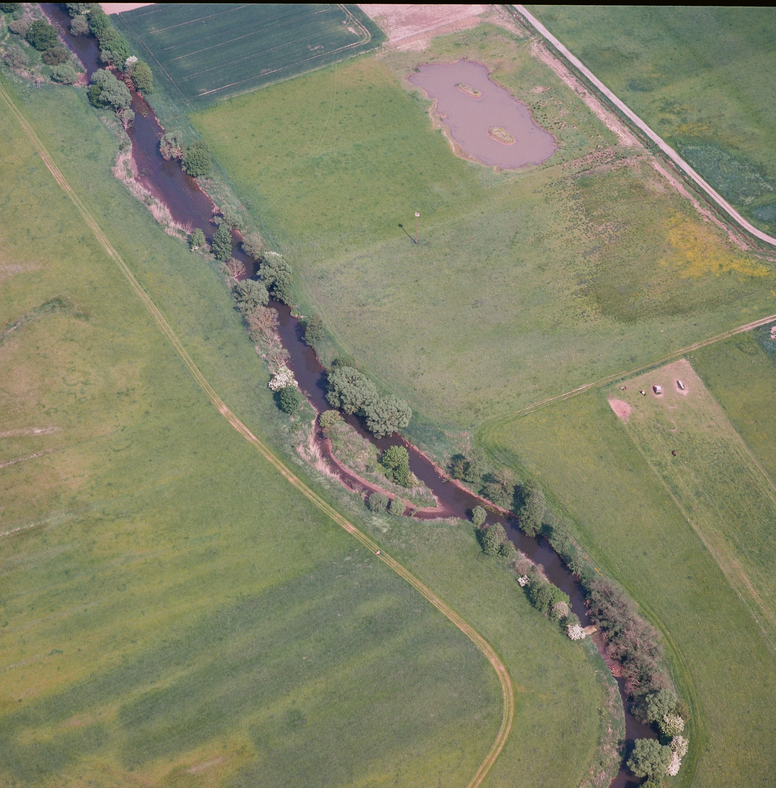
Aerial view looking down at a winding river flowing through green grasslands and fields in a nature reserve.
Aerial view of the Nachtweid nature reserve and the meandering Nidda River.

Nachtweid von Dauernheim history and protected-area timeline

The area now known as Nachtweid von Dauernheim was formally designated as a nature reserve ("Naturschutzgebiet") in 1978 under the official identifier 1440005 within the state of Hesse's protected-area system. Its protection status reflected both its grassland conservation value and, increasingly, its recognition as a critically important habitat for marshland birds.

In December 2011, an observation hut was constructed on the northern edge of the reserve. This addition reflected the growing importance of the site for birdwatchers and ecological monitoring, providing a low-impact vantage point from which visitors and researchers can observe the wetland birds without disturbing sensitive nesting and feeding habitat.

Nachtweid von Dauernheim landscape and geographic character

Nachtweid von Dauernheim sits in the low-relief agricultural landscape characteristic of the eastern Wetterau. The terrain is gently undulating rather than mountainous, with the reserve occupying a flat to slightly dished area that collects groundwater rather than shedding it. This topography is central to the reserve's character, allowing wet meadows and sedge marshes to persist where better-drained surroundings have long since been converted to cropland.

The reserve is bordered and partly shaped by two important hydrological features: the Nidda river, which passes along the eastern edge, and the Heggraben ditch, which cuts through the area. These waterways maintain the saturated soils that support the open wetland habitat. Surrounding the reserve, the landscape is dominated by farmland, villages, and transport corridors, including the A 45 autobahn to the west and the B 275 federal road to the south and east. Directly southwest, the landscape transitions into the neighboring protected area "Am Mähried bei Staden," reinforcing the wetland mosaic of the region. To the larger east, Nachtweid von Dauernheim merges into the Auenverbund Wetterau landscape protection area, emphasizing its position within a connected floodplain network.

Nachtweid von Dauernheim ecosystems, habitats, and plant life

Ecologically, Nachtweid von Dauernheim is defined by its open grassland habitats rather than woodland. The reserve protects extensive wet meadows, reed-fringed marsh zones, and well-developed Großseggenriede (large sedge marsh) communities. These habitats are anchored by consistently high groundwater levels, reinforced by the adjacent Nidda river and the Heggraben ditch that runs through the area.

The defining ecological peculiarity of the reserve is the saline influence that emerges from mineral-rich springs rising through the rooted soil horizons. This produces locally halophilic and halotolerant plant communities, a phenomenon rarely encountered in inland central Germany. Sixteen Red List plant species for Hesse have been documented in the reserve as a whole, and a striking six of those species are concentrated in this comparatively small saline zone. The combination of saline grassland, classic wet meadow, and sedge marsh creates a layered vegetation mosaic unusual for the region.

Nachtweid von Dauernheim wildlife and species highlights

Nachtweid von Dauernheim is nationally recognized for its rail bird fauna and is widely described as the most important rail biotope in Hesse. Rails and related marshland birds thrive in the reserve's mix of wet meadows, reedbeds, and sedge marshes, where dense vegetation, shallow water, and minimal disturbance provide ideal breeding and feeding conditions. The site's significance is measured both by the number of rail species recorded and by the sheer abundance of individuals observed during monitoring.

In December 2011, a dedicated observation hut was built on the northern edge of the reserve to support birdwatching and ornithological monitoring without disturbing sensitive habitat. The broader mosaic of wet grassland and sedge marsh also supports a wider community of wetland-associated fauna, though the rail population remains the single most distinctive wildlife feature of Nachtweid von Dauernheim.

Nachtweid von Dauernheim conservation status and protection priorities

Nachtweid von Dauernheim has been formally protected as a Hessian nature reserve since 1978, with the official designation number 1440005. Its conservation importance rests on a rare combination of saline grassland habitat and high-value marshland bird habitat, both of which are priorities in regional biodiversity protection efforts for the Wetterau.

The reserve's saline flora is a key asset for conservation: six of sixteen Hessian Red List plant species recorded in the area are tied to the mineral-rich, locally saline soils, giving the site an outsized botanical significance relative to its size. The dense rail populations further reinforce its role as a reference site for marshland bird conservation in central Germany. The reserve is also embedded in a broader protected landscape, bordered largely by the Auenverbund Wetterau landscape protection area and adjacent to the protected area Am Mähried bei Staden, integrating it into a larger network of floodplain and grassland conservation.

Nachtweid von Dauernheim cultural meaning and human context

Nachtweid von Dauernheim is fundamentally a product of traditional agricultural land use rather than wilderness. The open grassland character of the reserve reflects generations of meadow management, grazing, and mowing practices that have maintained the non-forested vegetation on which its saline flora and rail birds depend.

Top sights and standout views in Nachtweid von Dauernheim

The standout qualities of Nachtweid von Dauernheim are its dual ecological specializations: a saline-influenced grassland flora that is genuinely rare in Hesse, and an exceptionally rich rail bird community that makes it a reference site for marshland ornithology in the state. Its 2011 observation hut reflects growing recognition of its value for low-impact wildlife watching and ecological monitoring.

The reserve's compact size belies its regional importance. By combining saline meadow, classic wet grassland, and large sedge marsh within a single protected area, and by linking directly into the broader Auenverbund Wetterau landscape protection area, Nachtweid von Dauernheim exemplifies how small, well-targeted reserves can punch far above their weight in regional biodiversity conservation.

Best time to visit Nachtweid von Dauernheim

The wet meadows and sedge marshes of Nachtweid von Dauernheim are most dynamically alive during the warmer months, when rail birds are most active and the saline meadow flora is in growth. Spring and early summer are typically when the reserve's marshland birdlife is at its peak activity, while late spring and early summer offer the most developed vegetation display for the saline and wet grassland plant communities. The observation hut on the northern edge is best used during these periods for unobtrusive wildlife viewing. Autumn and winter bring quieter conditions, colder wetland scenery, and reduced bird activity, though the open landscape retains its character year-round.

Monthly climate preview

Long term representative point measurements for monthly temperature and precipitation rhythm

Nachtweid von Dauernheim Climate Normals and Annual Temperature Range

Nachtweid von Dauernheim records long term monthly temperature averages spanning sub zero winter lows to warm summer maximums alongside steady daily precipitation. Examining the complete twelve month climate profile reveals detailed shifts in temperature and moisture across the representative coordinate.
Annual mean9 °C
-1 °C19 °C
Jan-1°
Feb
Mar
Apr
May13°
Jun16°
Jul19°
Aug19°
Sep14°
Oct
Nov
Dec
Warmest month
July

18.8 °C

Coolest month
January

-0.6 °C

Wettest month
July

2.5 mm/day

Driest month
April

1.6 mm/day

Park location guide

Geography guide, regional context, and park location map for Nachtweid von Dauernheim

Nachtweid von Dauernheim park geography, regions, and map view in Germany

Understand where Nachtweid von Dauernheim sits in Germany through a broader geographic reading of the surrounding landscape, nearby location context, and its mapped position within the national park landscape.

How Nachtweid von Dauernheim fits into Germany

Germany is a federal republic in Western and Central Europe with a population of over 83 million across sixteen constituent states. It is Europe's largest economy by nominal GDP and a major global exporter and importer. The capital is Berlin, and the country borders Denmark, Poland, Czech Republic, Austria, Switzerland, France, Luxembourg, Belgium, and the Netherlands.

Wider geography shaping Nachtweid von Dauernheim in Germany

Germany is located in Western and Central Europe, spanning 357,022 km². It borders Denmark to the north, Poland and the Czech Republic to the east, Austria and Switzerland to the south, and France, Luxembourg, Belgium, and the Netherlands to the west. The country has coastlines on the Baltic Sea and North Sea to the north, with the Alps located in the southern region.

Map view of Nachtweid von Dauernheim

Use this park location map to pinpoint Nachtweid von Dauernheim in Germany, understand its exact geographic position, and read its mapped placement within the surrounding landscape more clearly.

Pigeon | © OpenStreetMap contributors

Location context for Nachtweid von Dauernheim

Hessen

Visual reference for wetland habitats and protected meadow terrain

Nachtweid von Dauernheim Photos and Landscape Scenery

Explore detailed photographs capturing the open grassland, wet meadows, and saline habitats defining Nachtweid von Dauernheim. Visual documentation reveals the flat terrain and specialized wetland environments supporting rare flora across the protected floodplain ecosystem.

Aerial view looking down at a winding river flowing through green grasslands and fields in a nature reserve.

An aerial landscape view shows a nature reserve with a wetland pond surrounded by green fields, a small structure, and tilled farmland in the foreground.

Park atlas

Compare surrounding wet meadows and regional floodplain reserves

Other Parks Near Nachtweid von Dauernheim and Related Protected Landscapes

Browsing other protected areas near Nachtweid von Dauernheim reveals connected wetland networks across the eastern Wetterau. Evaluating these adjacent reserves provides deeper geographic context for regional grassland and floodplain conservation habitats.
A horizontal watercolor painting showing a wetland landscape with gentle rolling hills, marshy vegetation, and scattered trees under a light sky.
Nature reserveHesse
About 4.7 km away#1 closest

Northwest

Bingenheimer Ried Nature Reserve: Mapped Floodplain Geography in Hesse

A critical lowland mire and wetland conservation network

Located in the Horloff valley, Bingenheimer Ried represents an essential protected landscape characterized by seasonal flooding and shallow mire habitats. This nature reserve supports significant bird populations and diverse aquatic life, functioning as a primary reference point for floodplain management and conservation geography within the state of Hesse.

Area
0.85 km²
Established
1985
A watercolor painting of a green, rolling meadow landscape with distant hills under a soft, light sky.
Nature reserveWetteraukreis
About 5.4 km away#2 closest

East

Nidderauen von Stockheim Nature Reserve: A Detailed Geographic and Protected Landscape Map

Wetland floodplain geography in the Wetteraukreis region

This protected nature reserve spans 51 hectares of the Nidder river valley, forming a critical segment of the Auenverbund Wetterau. The landscape is defined by its mosaic of wet meadows, ponds, and tall herb vegetation, maintained by targeted conservation management and river restoration. Access the map-driven context of this European FFH site to understand its role in regional wetland preservation and habitat connectivity.

Area
0.512 km²
Established
1981
Relief
Lowland
Climate
Temperate
Protected areaGermany
About 6.1 km away#3 closest

Southeast

Bruch von Heegheim Protected Area: A Wetland Landscape in the Nidder River Valley

Mapped wetland habitats and ecological site geography

Bruch von Heegheim is a specialized nature reserve that protects a delicate mosaic of shallow water bodies and reed-dominated marshes in the German district of Wetteraukreis. The site serves as a vital refuge for European tree frogs and breeding marshland birds, demonstrating how compact protected lands contribute to broader biodiversity conservation within agricultural floodplains.

Area
0.108 km²
Established
1976
Relief
Lowland
Climate
Temperate
Nature reserveHesse
About 8.4 km away#4 closest

South

Im Rußland und in der Kuhweide bei Lindheim: Nature Reserve and Floodplain Geography

Protected grassland landscapes in the Wetterau, Hesse.

Located in the Wetteraukreis district of Hesse, this nature reserve protects extensive floodplain meadows along the Nidder river. The area is defined by its open grassland mosaic, providing critical refuge for meadowbirds and diverse amphibian populations. Access detailed map data and landscape context for this significant German conservation site.

Area
2.495 km²
Established
1984
Relief
Lowland
Climate
Temperate
Watercolor painting of a green landscape with rolling hills, small clusters of trees, and soft pinkish tones in the background.
Nature reserveHesse
About 13 km away#5 closest

Southwest

Krebsbachtal bei Kaichen: Protected Stream Valley Geography and Landscape Map in Hesse

Nature reserve featuring diverse meadow and forest habitat mosaics

Spanning 34 hectares in the Main-Kinzig-Kreis, the Krebsbachtal bei Kaichen reserve protects a unique concentration of riparian stream life, dry grasslands, and traditional orchard meadows. This valley landscape, framed by the Hainwald forest, provides a protected corridor that remains a significant representative of the historic natural terrain found in central Hesse.

Area
0.34 km²
Established
1988
Relief
Lowland
Climate
Temperate
A wide watercolor painting showing a green river valley with marshy foreground, a line of trees, and rolling hills in purple and green in the background.
Nature reserveWetteraukreis
About 13 km away#6 closest

West

Salzwiesen von Wisselsheim Nature Reserve: Atlas and Regional Geography of Wetteraukreis

Protected inland salt meadows and floodplain geography in Hesse, Germany.

Salzwiesen von Wisselsheim stands as a significant protected area in the Wetteraukreis region, distinguished by rare inland salt meadows fed by natural saline springs. This reserve presents a compelling landscape defined by the River Wetter, offering deep insights into how unique hydrogeology and historical salt production have formed a specialized lowland habitat that is largely absent from other inland regions.

Area
0.23 km²
Established
1982
Relief
Lowland
Climate
Temperate
A watercolor painting showing a soft, peaceful landscape with green rolling hills, a small body of water in the foreground, and faint, distant mountains under a pale sky.
Nature reserveHesse
About 15 km away#7 closest

West

Kiesgrube Laukertsberg bei Nieder-Mörlen Protected Area in Hesse, Germany

A reclaimed post-industrial nature reserve and habitat

Located in the Wetterau district of Hesse, Kiesgrube Laukertsberg bei Nieder-Mörlen represents a significant shift from industrial gravel extraction to protected ecological sanctuary. The terrain features open-ground habitats and seasonal wetlands that support sensitive species, illustrating how landscape management can prioritize biodiversity. Analyze the site boundaries and its role within the broader regional geography of central Germany.

Area
0.157 km²
Established
2019
IUCN
IV
Relief
Lowland
A wide watercolor illustration showing a purple mountain in the distance, a line of green trees, a body of water, and pinkish plants in the foreground on a white background.
Nature reserveWetteraukreis
About 15 km away#8 closest

Northwest

Breitwiese bei Steinfurth und Oppershofen: A Wetteraukreis Nature Reserve Profile

Examining floodplain ecology and protected wetland boundaries

This protected area in the Wetteraukreis highlights the importance of small-scale floodplain management for biodiversity. The site preserves essential wet meadow habitats, riparian edges, and river-adjacent ecosystems that provide sanctuary for specialized amphibian and bird species. It serves as an informative case study for understanding how conservation grazing and corridor protection interact within an intensive agricultural landscape.

Area
0.164 km²
Established
1990
IUCN
IV
Relief
Lowland

Common questions about visiting, size, designation, and location context for Nachtweid von Dauernheim

Nachtweid von Dauernheim FAQs for park facts, access, geography, and protected area context

Find quick answers about Nachtweid von Dauernheim, including protected-area facts, park geography, trail and visitor context, and how the park fits into its surrounding country and regional landscape.
MoriAtlas Explorer

Continue Your Protected Areas Search Across the Global Atlas

Deepen your exploration by continuing the structured search for national parks and protected areas worldwide. Utilize the comprehensive filtering capabilities to compare different conservation landscapes and refine your understanding of global park geography. Discover more about the distribution and characteristics of protected natural areas.

Global natural geography