Mori Atlas logo
Nature reserveNagelfluhkette Nature Park

Understanding the cross-border geology, ridge formations, and alpine terrain of a unique German nature reserve.

Nagelfluhkette Nature Park: Mapped Geography and Protected Landscapes in the Bavarian Alps

(Naturpark Nagelfluhkette)

Nagelfluhkette Nature Park represents a landmark cross-border protected area between Bavaria and the Austrian state of Vorarlberg. Centered on distinctive conglomerate rock ridges that resemble embedded nail heads, this reserve spans significant vertical relief from valley floors near the Iller and Bregenzerach rivers to rugged peaks exceeding 2,000 meters. The mapped terrain encompasses diverse habitats, including the expansive Großer Alpsee, Hochhädrich moorlands, and high alpine meadows that characterize this transition zone in the eastern Alps.

alpine landscapecross-border nature parknagelfluh conglomeratepre-alpine ridgesmoorlandsalpine lakes

Nagelfluhkette Nature Park

Nature reserve

Park overview

Structured park overview, official facts, and landscape profile for Nagelfluhkette Nature Park

Nagelfluhkette Nature Park park facts, protected area profile, and essential visitor context

Review the core facts for Nagelfluhkette Nature Park, including designation, size, terrain, visitor scale, habitats, and operating context in one park-focused overview.

About Nagelfluhkette Nature Park

Nagelfluhkette Nature Park lies at the meeting point of two countries and two distinct alpine cultural regions: the Bavarian Allgäu in southern Germany and the Bregenzerwald in western Vorarlberg, Austria. Encompassing roughly 24,700 hectares in the Oberallgäu district and about 16,300 hectares across the border, the park stretches from the western slopes of the Iller valley near Immenstadt through the Konstanzer Tal and Oberstaufen in the north, continuing westward toward the Hirschberg ridge near Bregenz. Southward, it reaches the Bregenzerach gorge and the Hochifen slopes near Oberstdorf.

The park's identity is built around three parallel Nagelfluh chains of the Allgäu Nagelfluh ridges: the Prodel-Kojen ridge in the north, the central Hochgrat chain that gives the park its name, and the Hörnergruppe (or Riedberghorn group) in the south. These ridges form a continuous backbone of conglomerate cliffs, alpine meadows, and deeply incised valleys. The Großer Alpsee, a sizable glacial lake near Immenstadt, anchors the northeastern part of the park, while the moorlands of Hochhädrich and the protected forests of the Bregenzerwald add further ecological variety.

Ecologically, the park functions as a corridor connecting protected areas on both sides of the border, including several Natura 2000 sites such as the Hochgrat-Steineberg FFH area, the Hörnergruppe, the Häderichmoore, and the Bregenzerach gorge. Administratively, it is coordinated by Naturpark Nagelfluhkette e. V., an association of eighteen municipalities working together on habitat conservation, sustainable alpine farming and forestry, regional energy strategies, and quality-focused tourism. The Alpine information center AlpSeeHaus at Bühl am Alpsee serves as the main visitor point for orientation, excursions, and educational programs.

Quick facts and research context for Nagelfluhkette Nature Park

Nagelfluhkette Nature Park is a cross-border protected area between Bavaria, Germany, and Vorarlberg, Austria, established in 2008.

It covers roughly 400 to 480 square kilometers (sources differ slightly) and includes the Allgäu Nagelfluh ridge system, the Großer Alpsee, the Hörnergruppe, and parts of the Bregenzerwald. The park is administered by the Naturpark Nagelfluhkette e. V., based in Bühl am Alpsee near Immenstadt.

Protection and recognition

Documented terrestrial protection scope and international recognition facts

Nagelfluhkette Nature Park Protection Status and Transboundary Geography

Nagelfluhkette Nature Park maintains a documented terrestrial protection scope across its transboundary landscape boundaries. Official records organize management details and international recognition data for reliable geographic analysis.

Protection details

Protection scope
Terrestrial
Transboundary protection
Yes
Park context

Deeper park guide and search-rich context for Nagelfluhkette Nature Park

Nagelfluhkette Nature Park history, landscape, wildlife, and travel context

Explore Nagelfluhkette Nature Park through its history, landscape character, ecosystems, wildlife, conservation priorities, cultural context, and seasonal travel timing in a structured park guide built for atlas discovery and search intent.

Why Nagelfluhkette Nature Park stands out

Nagelfluhkette Nature Park is best known for its namesake geological feature, the Nagelfluh conglomerate, a striking rock composed of rounded pebbles cemented so tightly that the embedded stones resemble the heads of nails driven into cliff faces. The park is also recognized for its dramatic vertical relief, with valley floors around 465 meters giving way within a short distance to peaks above 2,000 meters. This sharp elevation gradient creates unusually varied habitats, from lakeside meadows and forests to alpine ridges, moorlands, and limestone-influenced summits.
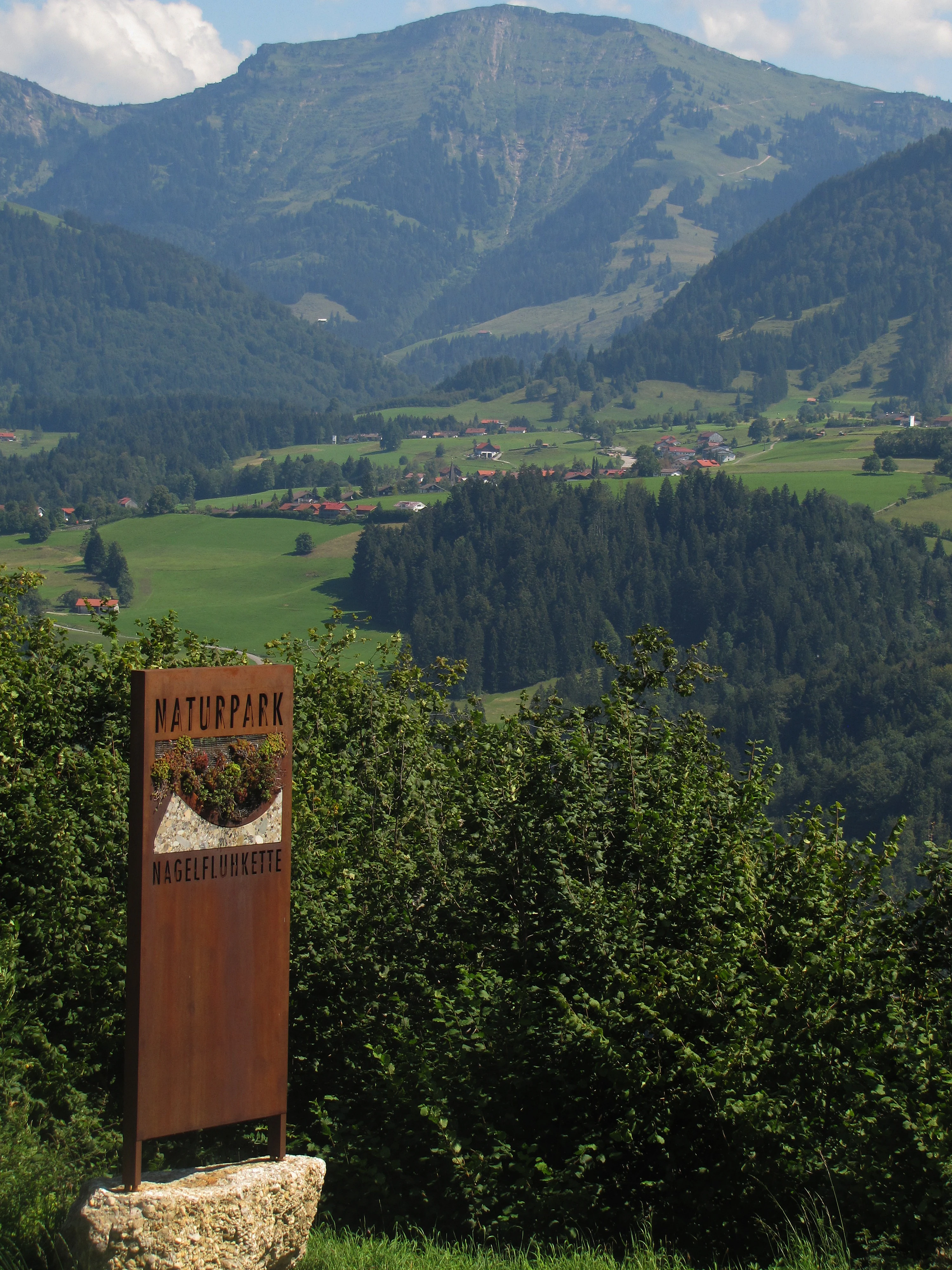
A tall, brown metal park entrance sign stands in the foreground, displaying the text Naturpark Nagelfluhkette; in the background, a large mountain rises above green meadows and forested slopes.
Information sign at the entrance of Nagelfluhkette Nature Park with alpine peaks in the background.

Nagelfluhkette Nature Park history and protected-area timeline

The idea for a cross-border nature park emerged in 2003 within the DYNALP project of the Alliance in the Alps community network, which examined how sustainable tourism could help preserve mountain farming. Funding from the European Union's INTERREG IIIA/IV Alpenrhein-Bodensee-Hochrhein program was approved in 2005, and between 2006 and 2007 the legal and organizational foundations were created in cooperation with the Austrian Ecology Institute and the German Alpine Research Institute.

The Bavarian portion of the park was officially approved on 1 January 2008 by the Bavarian Ministry of the Environment, registered as NP-00018 (BAY-18), and notably became the first Bavarian nature park located in the Alps. The Vorarlberg portion followed on 2 September 2014. Because nature parks in Vorarlberg are not a formal protected-area category under state law but rather a voluntary commitment by participating municipalities, the Austrian side of the park is structured as a regional development strategy supported by the provincial government, similar in approach to the Biosphärenpark Großes Walsertal.

Nagelfluhkette Nature Park landscape and geographic character

The landscape of Nagelfluhkette Nature Park is defined by the contrast between broad valley floors and steep, jagged ridge crests. The Großer Alpsee, with its shoreline protected as a landscape protection area, occupies a central position in the eastern part of the park, framed by slopes that climb through mixed forest into open alpine pasture. The Nagelfluh ridges themselves form a wall of conglomerate cliffs that run roughly east to west, with the Hochgrat (1,834 meters) and Steineberg (1,660 meters) among the most prominent summits.

To the north, the Prodel-Kojen ridge steps down toward the Konstanzer Tal and the gentler moor and forest landscapes around Oberstaufen. To the south, the Hörnergruppe rises with sharper, more rugged profiles before giving way to the Bregenzerach gorge and the western flank of the Nagelfluh chain near the Hochhädrich and Hirschbergzug. Over a relatively short horizontal distance, the terrain descends from around 2,000 meters to roughly 465 meters, producing habitats from alpine scree and meadows down through coniferous forest, valley bogs, and lakeside wetland.
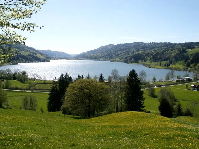
A wide landscape view of a large, sunlit lake surrounded by rolling green hills and forests.
A view overlooking the Grosser Alpsee in the Nagelfluhkette Nature Park region.

Nagelfluhkette Nature Park ecosystems, habitats, and plant life

The varied topography of the park supports a correspondingly broad range of habitats. The conglomerate cliffs and ridge meadows of the Nagelfluh chains alternate with the open moorland of the Häderichmoore, dark conifer forests of the Bregenzerwald slopes, agricultural meadows along the Iller and Bregenzerach valleys, and the reed-lined shores of the Großer Alpsee. Several protected areas fall fully or partly within the park, including the FFH sites Nagelfluhkette Hochgrat-Steineberg, Hörnergruppe, Häderichmoore, and Bregenzerachschlucht, as well as landscape protection areas around the Nagelfluhkette and Großer Alpsee.

In Vorarlberg, additional protections include the Kojen-Moos, Rossbad, and Hirschberg nature reserves, while on the Bavarian side the broad landscape protection areas create a buffer around the more strictly designated zones. Together, these designations emphasize the park's role as a transitional landscape, linking alpine ecosystems with subalpine forest, wetland, and culturally shaped pastureland.
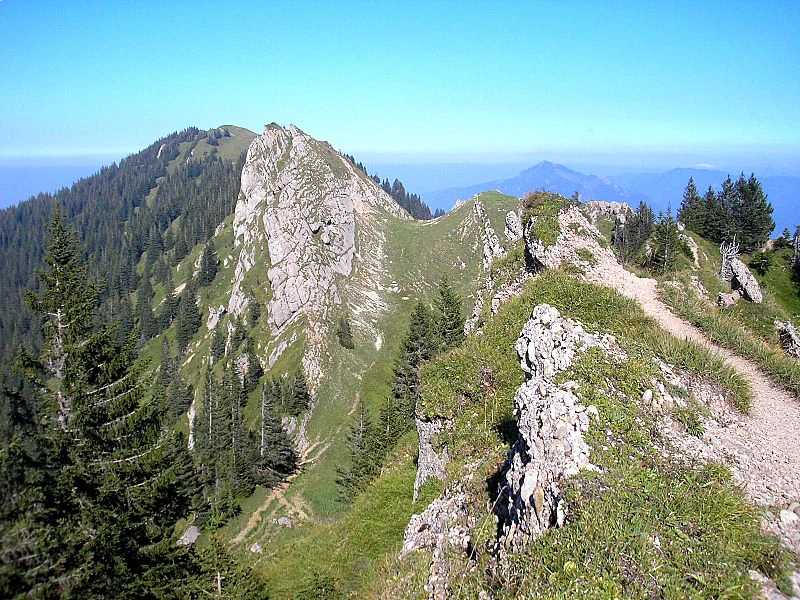
A jagged rocky mountain peak rises sharply above a grassy, forested ridge with a hiking trail running along the spine.
The summit of Steineberg rising above the Nagelfluhkette ridge.

Nagelfluhkette Nature Park wildlife and species highlights

The park's mix of cliffs, alpine meadows, moorlands, and forests supports a notable variety of fauna. Birdlife includes black grouse in the higher forested zones and golden eagles soaring above the ridge crests. Among invertebrates, the rare Apollo butterfly has been recorded in suitable meadow habitats. The protected moorlands and wet forest edges also host a range of species tied to these specialized environments, while the broader mosaic of habitats supports typical Allgäu and Bregenzerwald mammals and smaller fauna across the elevation gradient.

Nagelfluhkette Nature Park conservation status and protection priorities

Nagelfluhkette Nature Park functions primarily as a coordinating framework linking multiple overlapping protection categories rather than as a single rigid reserve. In Bavaria it is registered as a nature park under the state environmental framework, while in Vorarlberg it operates as a voluntary municipal commitment integrated into the province's regional development and conservation strategy. This dual structure allows the park to combine Natura 2000 sites, landscape protection areas, and smaller nature reserves into a coherent conservation approach.

The park's conservation focus emphasizes the maintenance of cultural landscapes shaped by alpine farming and forestry, recognition of the conglomerate geology as a defining feature, and protection of transitional habitats between valley, forest, ridge, and moor. By aligning ecological objectives with sustainable regional development, the park aims to keep traditional land-use practices viable while safeguarding the long-term integrity of its varied ecosystems.

Nagelfluhkette Nature Park cultural meaning and human context

The park reflects a long history of cross-border interaction between the Bavarian Allgäu and the Vorarlberger Bregenzerwald, two regions with strong but distinct alpine identities. Traditional alpine farming, particularly the seasonal use of high pastures, has shaped the meadows and forest edges that visitors see today, and remains an explicit focus of the park's conservation strategy.

On the Austrian side, the park is embedded in a regional development tradition that includes the Biosphärenpark Großes Walsertal and the broader Vorarlberg approach of linking landscape protection with municipal cooperation. The integration of energy sustainability themes and quality-focused tourism ties the park closely to contemporary rural development strategies in both countries, making it as much a cultural cooperation project as an ecological one.

Top sights and standout views in Nagelfluhkette Nature Park

Nagelfluhkette Nature Park's standout qualities include the unusual Nagelfluh conglomerate geology, with cliffs that appear studded with rounded pebbles like nail heads. The park also stands out for combining alpine ridge scenery, lakeside landscapes around the Großer Alpsee, and the protected moorlands of the Hochhädrich within a single accessible cross-border area.

Its status as the first cross-border nature park between Germany and Austria gives it a distinct institutional identity, and the close integration of alpine farming, forestry, and tourism with ecological protection makes it a notable example of integrated rural landscape management in the eastern Alps.

Best time to visit Nagelfluhkette Nature Park

Summer is the most favorable season for exploring the Nagelfluhkette Nature Park, when hiking trails across the ridge crests and valley meadows are typically accessible and the alpine flora is at its most visible. The higher summits, including the Hochgrat and Steineberg, can offer expansive panoramic views over the Allgäu and Vorarlberg during this period.

In winter, the area transitions into a quieter landscape where snowshoe hiking and ski touring become the main ways to experience the park. The combination of frozen lakes, snow-covered ridges, and silent forest valleys gives the park a very different but equally atmospheric character in the colder months, while spring and autumn tend to bring softer light and visible transitions between the park's meadow, forest, and alpine zones.

Monthly climate preview

Long-term representative point measurements tracking monthly temperature ranges and precipitation patterns

Nagelfluhkette Nature Park Climate Normals, Annual Temperature and Precipitation Rhythms

Nagelfluhkette Nature Park exhibits sustained negative mean temperatures during winter months alongside rising precipitation peaks through midsummer periods. Reviewing the complete twelve-month climate record provides full statistical context for long-term meteorological variations.
Annual mean7 °C
-3 °C16 °C
Jan-3°
Feb-2°
Mar
Apr
May11°
Jun14°
Jul16°
Aug16°
Sep12°
Oct
Nov
Dec-2°
Warmest month
July

16.2 °C

Coolest month
January

-2.8 °C

Wettest month
June

5.4 mm/day

Driest month
February

2.7 mm/day

Park location guide

Geography guide, regional context, and park location map for Nagelfluhkette Nature Park

Nagelfluhkette Nature Park park geography, regions, and map view in Germany

Understand where Nagelfluhkette Nature Park sits in Germany through a broader geographic reading of the surrounding landscape, nearby location context, and its mapped position within the national park landscape.

How Nagelfluhkette Nature Park fits into Germany

Germany is a federal republic in Western and Central Europe with a population of over 83 million across sixteen constituent states. It is Europe's largest economy by nominal GDP and a major global exporter and importer. The capital is Berlin, and the country borders Denmark, Poland, Czech Republic, Austria, Switzerland, France, Luxembourg, Belgium, and the Netherlands.

Wider geography shaping Nagelfluhkette Nature Park in Germany

Germany is located in Western and Central Europe, spanning 357,022 km². It borders Denmark to the north, Poland and the Czech Republic to the east, Austria and Switzerland to the south, and France, Luxembourg, Belgium, and the Netherlands to the west. The country has coastlines on the Baltic Sea and North Sea to the north, with the Alps located in the southern region.

Map view of Nagelfluhkette Nature Park

Use this park location map to pinpoint Nagelfluhkette Nature Park in Germany, understand its exact geographic position, and read its mapped placement within the surrounding landscape more clearly.

Pigeon | © OpenStreetMap contributors

Location context for Nagelfluhkette Nature Park

BavariaVorarlberg

Visual exploration of ridge terrain, alpine lakes, and protected habitats

Nagelfluhkette Nature Park Photos and Landscape Scenery

Visual records capture the distinctive conglomerate rock formations, steep mountain ridges, and broad valley floors defining the protected terrain. Detailed imagery reveals varied habitats spanning from high alpine summits down to forested slopes and sheltered lake basins.

A tall, brown metal park entrance sign stands in the foreground, displaying the text Naturpark Nagelfluhkette; in the background, a large mountain rises above green meadows and forested slopes.

A rocky mountain ridgeline with a narrow hiking trail winding along the crest, surrounded by alpine slopes and pine forests under a clear blue sky.

A wide landscape view of a large, sunlit lake surrounded by rolling green hills and forests.

A jagged rocky mountain peak rises sharply above a grassy, forested ridge with a hiking trail running along the spine.

Park atlas

Compare adjacent mountain reserves, ridge systems, and cross border landscapes.

Explore Parks Near Nagelfluhkette Nature Park and Surrounding Alpine Protected Areas

Browsing other parks near Nagelfluhkette Nature Park reveals connected alpine topography, high altitude ridges, and protected valley ecosystems across the surrounding region. Extending the geographic comparison uncovers broader conservation patterns and regional park networks throughout the Bavarian and Vorarlberg borderlands.
A watercolor painting showing a panoramic view of a wetland with coniferous trees, soft green forest lines, and reddish bog vegetation against a pale background.
Nature reserveBaden-Württemberg
About 20 km away#1 closest

North

Bodenmöser und Hengelesweiher Nature Reserve: Mapped Geography and Protected Wetland Atlas

A diverse mosaic of peatlands and lakes in Westallgäu

Bodenmöser und Hengelesweiher represents a significant conservation network in southwestern Germany. This detailed view covers the distribution of calcareous fens, raised bogs, and dark-water pools that characterize the pre-Alpine hill landscape. Learn about the geographic configuration of this protected site as it bridges nutrient-poor lake ecosystems with surrounding alder woodlands and wet meadow corridors near Isny im Allgäu.

Area
7.59 km²
Established
2019
A soft watercolor painting showing rolling green hills and a forested ridgeline against a pale sky on a white background.
Nature reserveBaden-Württemberg
About 21 km away#2 closest

North

Adelegg Nature Reserve: Geographic Profile of an Alpine-Influenced Forested Ridge in Baden-Württemberg

Mapping deep ravine terrain and protected forest mosaics in Germany

The Adelegg nature reserve represents a vital Natura 2000 site within the Westallgäu region. This protected area features a striking vertical relief composed of steep, forested slopes and high-elevation grasslands. Explore the geographic layout of this ridge, which includes a complex array of calcareous beech forests, rare orchid habitats, and diverse ravine ecosystems that define this rugged southwestern German landscape.

Area
6.33 km²
Established
2019
Relief
Mountain
Climate
Temperate
A horizontal watercolor illustration depicting a soft, atmospheric landscape with marshy ground, scattered evergreen trees, and distant hills.
Nature reserveLandkreis Oberallgäu
About 23 km away#3 closest

Northeast

Schönleitenmoos im Wierlinger Forst Protected Nature Reserve and Allgäu Bog Landscape

Raised bog geography on the Rhine-Danube watershed in Germany.

Schönleitenmoos im Wierlinger Forst is a compact nature reserve characterized by its well-preserved raised bog sequence and post-glacial origins. This site in the Oberallgäu district is essential for studying peatland vegetation zones and the rare occurrence of the rust-leaved alpine rose outside the high Alps, offering a detailed perspective on Bavarian landscape formation.

Area
0.23 km²
Established
1960
Watercolor illustration of a lush natural ravine with a small cascading waterfall, surrounded by green forest slopes and distant rolling hills.
Nature reserveBavaria
About 25 km away#4 closest

Northeast

Rohrbachtobel im Wirlinger Forst Nature Reserve and Bavarian Pre-Alpine Forest Geography

Mapped protected gorge landscapes and molasse geology in the Oberallgäu district

Rohrbachtobel im Wirlinger Forst offers a unique look at small-scale protected landscapes in Germany. This nature reserve features a dramatic stream-cut gorge and serves as a natural habitat for diverse plant species, including European yew and multiple orchid varieties, within the wider context of the Bavarian pre-Alpine forest zone.

Area
0.14 km²
Established
1959
Relief
Upland
Scope
Terrestrial
A watercolor painting showing a panoramic view of a wetland with water, grasses in the foreground, green hills, and purple-toned mountains in the distance.
Nature reserveVorarlberg
About 32 km away#5 closest

West

Rhine Delta Nature Reserve: Mapped Wetlands and Alpine Foothills Geography in Vorarlberg

A dynamic freshwater delta and critical bird habitat in Austria

The Rhine Delta constitutes the largest wetland biotope on Lake Constance, characterized by ongoing sediment deposits and an evolving shoreline. Its geography includes dense riparian forests, alluvial plains, and shallow bays that provide refuge for diverse amphibians and birds. This nature reserve serves as a prime example of large-scale wetland conservation nestled between the Alpine foothills and the open waters of the lake.

Area
20.65 km²
Established
1982
Relief
Lowland
Climate
Temperate
A soft watercolor painting of a rolling landscape featuring a winding river, grassy plains, and distant hills in muted green, pink, and yellow tones.
Protected landscapeBodenseekreis
About 38 km away#6 closest

Northwest

Spätwürmeiszeitliche Terrassen zwischen Burnau, Prestenberg, Vorderreute, Buch und Krumbach Geography

A protected landscape site in the Bodenseekreis district

Spätwürmeiszeitliche Terrassen zwischen Burnau, Prestenberg, Vorderreute, Buch und Krumbach is defined by its series of level river terraces resulting from Würm ice age glacial retreat. Spanning roughly 22 hectares near the Schwarzach river, the site remains a vital example of fluvioglacial geomorphology and regional landscape preservation within the pre-Alpine foreland.

Area
0.22 km²
Established
1963
Relief
Upland
Climate
Temperate
Protected landscapeBaden-Württemberg
About 39 km away#7 closest

North

Uferbewuchs der Eschach Protected Landscape and Riparian Corridor Map

Riparian conservation within the Riß-Aitrach-Platten of Baden-Württemberg

Tracing the protected linear riparian corridors of the Eschach stream, this area is a significant example of urban-edge conservation in Germany. It maintains continuous stream-bank vegetation through the Leutkirch municipal landscape, linking directly to broader floodplain habitats of the Aitrach river system through its glacial-plateau geographic setting.

Established
1953
IUCN
V
Protected landscapeBaden-Württemberg
About 39 km away#8 closest

West

Steilrand und Schotterfeld des Argentals südlich der Kochermühle Protected Landscape Atlas

Glacial geomorphology and river terrace geography in Baden-Württemberg

This protected area provides a diagrammatic view of the Argen valley's ice-age origins. By preserving a Late Glacial terrace complete with its characteristic steep edge and gravel-strewn surfaces, it offers an essential geographic reference for understanding the retreat of the Würm ice within the wider Bodenseebecken region.

Area
0.081 km²
Established
1954
Relief
Lowland
Climate
Temperate

Common questions about visiting, size, designation, and location context for Nagelfluhkette Nature Park

Nagelfluhkette Nature Park FAQs for park facts, access, geography, and protected area context

Find quick answers about Nagelfluhkette Nature Park, including protected-area facts, park geography, trail and visitor context, and how the park fits into its surrounding country and regional landscape.
MoriAtlas Explorer

Continue Your Protected Areas Search Across the Global Atlas

Deepen your exploration by continuing the structured search for national parks and protected areas worldwide. Utilize the comprehensive filtering capabilities to compare different conservation landscapes and refine your understanding of global park geography. Discover more about the distribution and characteristics of protected natural areas.

Global natural geography