
Mori Atlas logo
Protected landscapeNagoldtal

A cross-municipal protected corridor balancing natural river dynamics and regional cultural landscapes

Nagoldtal Protected Landscape and River Valley Geography in the Calw District of Baden-Württemberg

(Landschaftsschutzgebiet Nagoldtal (Landkreis Calw))

Nagoldtal represents a major protected landscape in the Calw district, covering a series of valley segments between Bad Liebenzell and Nagold. This area defines the transition between the Schwarzwald-Randplatten and the Obere Gäue, preserving the distinct valley scenery where Black Forest slopes meet the elevated plateau country. Through its eight-part structure, the protected area maintains a corridor of near-natural river corridors and open meadow slopes across the northern Black Forest fringe.

landscape protection areavalley landscapeBlack Forest fringeriver valleycultural landscapenorthern Black Forest
A stylized illustration showing a winding river flowing through a deep valley with steep cliffs, pine forests, and a tall waterfall in the distance under a bright sky.

Nagoldtal

Protected landscape

Park overview

Structured park overview, official facts, and landscape profile for Nagoldtal

Nagoldtal park facts, protected area profile, and essential visitor context

Review the core facts for Nagoldtal, including designation, size, terrain, visitor scale, habitats, and operating context in one park-focused overview.

About Nagoldtal

Nagoldtal is one of the larger landscape protection areas in the northern Black Forest region, focused not on a single contiguous wilderness but on the interconnected valley landscape of the Nagold River across multiple communities. With eight separate sub-areas totaling several thousand hectares, the designation is shaped by the long cultural history of the valley, where settlements, agriculture, forestry, and natural river corridors coexist.

The protected area lies in a classic transitional geography. To the south and west, the terrain rises into the forested heights typical of the northern Black Forest; to the north and east, it opens toward the Obere Gäue, the higher plateau country characterized by mixed land use. The valley itself, with its river meanders, slopes, meadows, and patches of woodland, illustrates the kind of near-natural cultural landscape that landscape protection categories (rather than stricter nature reserve categories) are designed to safeguard.

Because the protection area is administered at the district (Landkreis) level rather than at the state national park level, its character is locally rooted. The ordinance establishing Nagoldtal explicitly references recreation use of typical landscape elements and protection against further suburban sprawl, indicating the dual goals of preserving scenic and ecological values while keeping the valley accessible and usable for local communities and visitors.

Quick facts and research context for Nagoldtal

Nagoldtal is a German landscape protection area with the official LSG number 2.35.037, classified under IUCN Category V (Protected Landscape/Seascape). It was established on 24 November 1971 by ordinance of the lower nature conservation authority at the Calw district office and is administered by Landkreis Calw.

The protected area includes 4,363.9 hectares across eight separate sub-areas and extends through twelve municipalities in the Calw district, including Calw, Bad Liebenzell, Nagold, Altensteig, Althengstett, Ebhausen, Neubulach, Rohrdorf, Schoemberg, Simmersfeld, Unterreichenbach, Wildberg, and Bad Teinach-Zavelstein. Its World Database on Protected Areas (WDPA) identifier is 323116.

Protection and recognition

Explore terrestrial protected area data and documented designation metrics for Nagoldtal.

Nagoldtal Protection Status and International Recognition Records

Nagoldtal maintains documented terrestrial protection status alongside verified database registry identifiers for conservation analysis. Designated records outline management scope and international recognition frameworks associated with the protected landscape.

Protection details

Protection scope
Terrestrial
Transboundary protection
No
WDPA ID
323116
Park context

Deeper park guide and search-rich context for Nagoldtal

Nagoldtal history, landscape, wildlife, and travel context

Explore Nagoldtal through its history, landscape character, ecosystems, wildlife, conservation priorities, cultural context, and seasonal travel timing in a structured park guide built for atlas discovery and search intent.

Why Nagoldtal stands out

Nagoldtal is best known for protecting a representative stretch of the Nagold River valley where the forested slopes of the Black Forest meet the more open uplands of the northern Black Forest fringe and the Obere Gäue. The protected area's eight-part composition reflects the way the valley landscape is fragmented by towns, roads, and cultural use, while still preserving coherent near-natural river valley scenery. The area is also notable for serving as one of a pair of Nagoldtal protection areas stretching along the same river system, with the Calw district section linking here to the Freudenstadt district's continuation further upstream. Together they form a notable river-valley protection corridor in the northern Black Forest region.
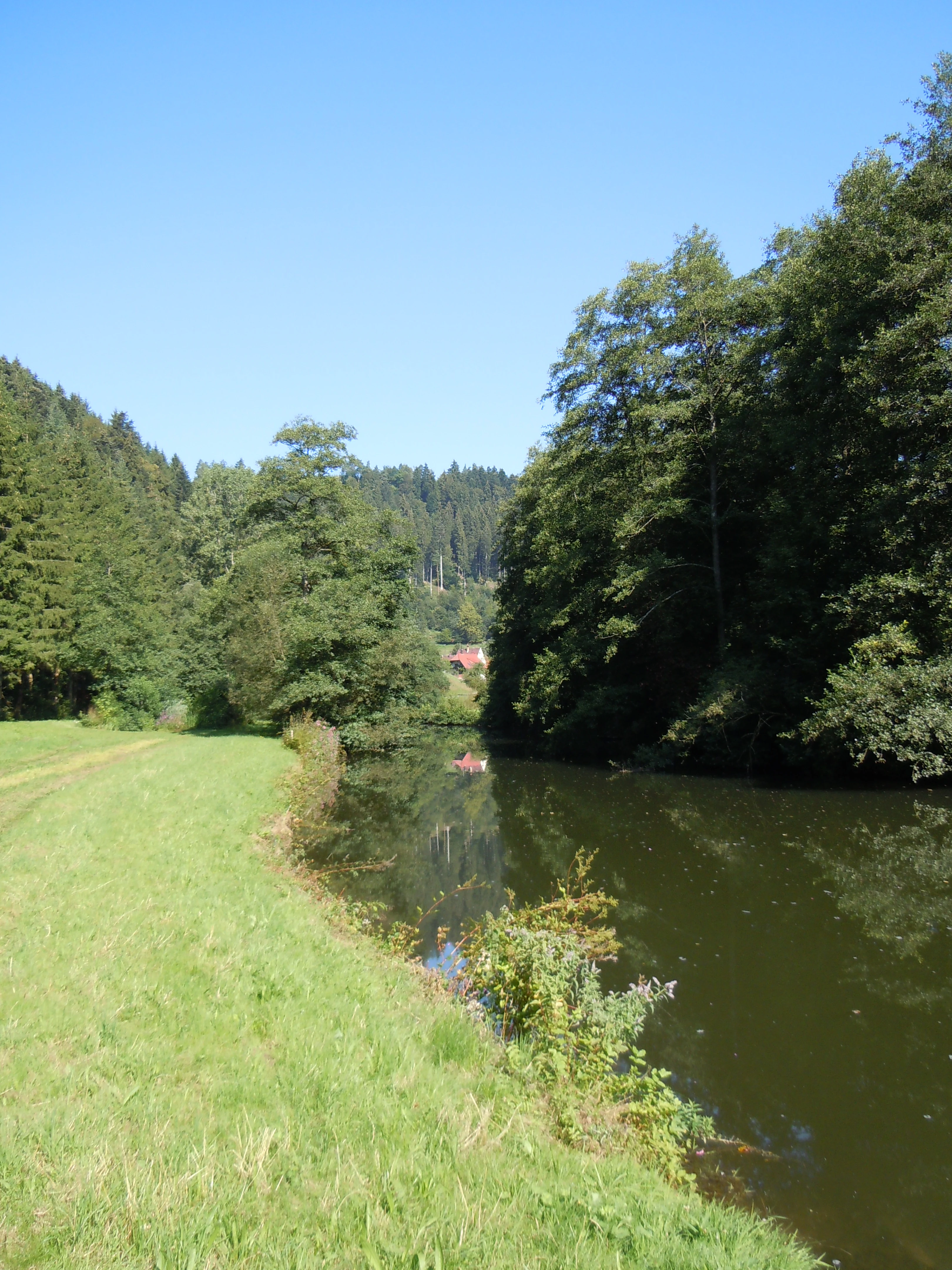
A peaceful, sunlit scene featuring the calm, reflective Nagold river winding past a grassy meadow, bordered by dense deciduous and coniferous forest under a clear blue sky.
The Nagold river flowing through a lush, tree-lined valley near Wildberg.

Nagoldtal history and protected-area timeline

Nagoldtal was formally designated as a protected landscape on 24 November 1971 through an ordinance issued by the lower nature conservation authority at the Landratsamt Calw. It is one of a group of landscape protection areas in the Calw district, established during a period when German states were systematically cataloguing and protecting representative regional landscapes under updated nature conservation frameworks.

The protection area was registered under LSG number 2.35.037, fitting into Baden-Wuerttemberg's broader system of landscape protection areas, and was later catalogued in the World Database on Protected Areas with the identifier 323116. At the southern end of the Calw district's portion, it borders a parallel protection area of the same name managed by the neighboring Freudenstadt district (LSG number 2.37.044), creating a continuous protected valley complex along the Nagold river system.

Nagoldtal landscape and geographic character

The Nagoldtal protection area's landscape is defined by the valley of the Nagold River, where forested Black Forest slopes descend toward flatter valley floors lined with meadows, settlements, and infrastructure. The terrain falls within two natural regions: the Schwarzwald-Randplatten, the stepped outer fringe of the northern Black Forest, and the Obere Gäue, the elevated Gäu plateau country that borders the forest to the north and east.

Because the protected area is divided into eight sub-areas, the landscape is best understood as a mosaic. Steeper, wooded slopes alternate with broader valley hollows, agricultural land, and small-town edges, reflecting the way long-established settlements such as Calw, Bad Liebenzell, Nagold, Wildberg, and Altensteig have shaped the valley over centuries. The valley scenery remains recognizably natural where the river and its slopes are intact, while human use is clearly visible in the broader land-use pattern.

Nagoldtal ecosystems, habitats, and plant life

Nagoldtal represents a near-natural cultural landscape typical of the northern Black Forest's outer fringe. The protected area preserves characteristic valley ecosystems along the Nagold River, including slopes carrying mixed and coniferous forest, valley-floor meadows, and small wetland fringes associated with the river and its tributaries.

As the area belongs to both the Schwarzwald-Randplatten and Obere Gäue natural regions, its ecological character reflects the transition between the dense forests of the higher Black Forest and the more open agricultural mosaic of the Gäu plateaus. The protection area's designation emphasizes that this mix of forest, meadow, river, and cultural land is itself the ecological asset being preserved, rather than any single habitat type.

Nagoldtal conservation status and protection priorities

Nagoldtal is classified as an IUCN Category V protected landscape, reflecting its role in maintaining a working cultural landscape that retains substantial natural and scenic values. The official protection purpose emphasizes the near-natural preservation of the Nagold valley, the safeguarding of characteristic landscape elements for recreational use, and the prevention of further settlement sprawl in the valley corridor.

By protecting eight discrete sub-areas across roughly 4,364 hectares, the designation acknowledges that conservation of this landscape must operate at a scale larger than any single reserve, and across multiple municipal jurisdictions. The Calw district's Nagoldtal ordinance also links ecologically and administratively to the parallel Nagoldtal protection area in the Freudenstadt district, extending the conservation corridor along the Nagold river system into a neighboring administrative region.

Nagoldtal cultural meaning and human context

The Nagold valley has a long history of human settlement, and the towns that the protected area crosses, including Calw, Bad Liebenzell, Nagold, Wildberg, Altensteig, and Bad Teinach-Zavelstein, are integral parts of the valley's identity. Calw in particular is closely associated with the writer Hermann Hesse, reinforcing the valley's broader cultural resonance in the northern Black Forest region.

The recognition of the valley as a near-natural cultural landscape in official protection records reflects an understanding that the Nagoldtal's value lies in the long interaction between communities and the river valley, rather than in untouched wilderness. The protection area's ordinance explicitly cites both the conservation of characteristic landscape elements and the value of the area for recreation, situating the cultural-landscape relationship at the center of its designation.

Top sights and standout views in Nagoldtal

Nagoldtal stands out for its unusually large, eight-part composition within a single district-administered landscape protection area, allowing a coherent river-valley protection concept to be applied across twelve different municipalities. Its location in the transition zone between the northern Black Forest and the Obere Gäue gives it ecological character distinct from purely forested mountain parks or plateau reserves.

The area is also notable for being paired directly with a same-named protection area in the neighboring Freudenstadt district, creating one of the more visible cross-district conservation corridors in Baden-Wuerttemberg. For visitors and local communities, the protected valley offers accessible northern Black Forest scenery shaped both by natural river-valley dynamics and by centuries of regional settlement.

Best time to visit Nagoldtal

As a valley landscape along the Nagold river, the area's most appealing scenery tends to occur during the warmer months, when valley meadows, forested slopes, and small tributaries are at their most visually expressive, and when walking and recreational use along the valley are most comfortable. Late spring and early autumn typically bring out contrasts between green valley floors and the forested slopes above, and the changing colors of the surrounding Black Forest fringes.

In winter, the valley scene shifts toward quieter, sparser conditions, with possible snow on the higher fringes, though the lower valley communities remain active year-round. Because the protection area spans a long stretch of valley through multiple municipalities, visitors will find accessible, locally-rooted scenery at nearly any season, with the character of a visit shaped more by chosen town or valley section than by strict seasonality.

Monthly climate preview

Long term temperature ranges and monthly precipitation averages for Nagoldtal

Nagoldtal Climate Normals and Representative Point Weather Patterns

Historical climate records from a representative coordinate inside Nagoldtal demonstrate a wide thermal spread between subzero winter minima and warm summer maximums alongside steady year round precipitation. Examining the complete twelve month data profile reveals detailed monthly fluctuations in average temperature and precipitation normals.
Annual mean8 °C
-1 °C18 °C
Jan-1°
Feb
Mar
Apr
May12°
Jun16°
Jul18°
Aug18°
Sep14°
Oct
Nov
Dec
Warmest month
July

18.1 °C

Coolest month
January

-0.9 °C

Wettest month
July

3.1 mm/day

Driest month
April

1.9 mm/day

Park location guide

Geography guide, regional context, and park location map for Nagoldtal

Nagoldtal park geography, regions, and map view in Germany

Understand where Nagoldtal sits in Germany through a broader geographic reading of the surrounding landscape, nearby location context, and its mapped position within the national park landscape.

How Nagoldtal fits into Germany

Germany is a federal republic in Western and Central Europe with a population of over 83 million across sixteen constituent states. It is Europe's largest economy by nominal GDP and a major global exporter and importer. The capital is Berlin, and the country borders Denmark, Poland, Czech Republic, Austria, Switzerland, France, Luxembourg, Belgium, and the Netherlands.

Wider geography shaping Nagoldtal in Germany

Germany is located in Western and Central Europe, spanning 357,022 km². It borders Denmark to the north, Poland and the Czech Republic to the east, Austria and Switzerland to the south, and France, Luxembourg, Belgium, and the Netherlands to the west. The country has coastlines on the Baltic Sea and North Sea to the north, with the Alps located in the southern region.

Map view of Nagoldtal

Use this park location map to pinpoint Nagoldtal in Germany, understand its exact geographic position, and read its mapped placement within the surrounding landscape more clearly.

Pigeon | © OpenStreetMap contributors

Location context for Nagoldtal

Baden-Württemberg

Explore photographic records of the Nagold River valley, forested slopes, and northern Black Forest fringe terrain.

Nagoldtal Photos and Scenery: Visualizing Protected Valley Landscapes

Visual records capture the distinctive topography of Nagoldtal, where steep wooded slopes meet open river meadows across the northern Black Forest. Examining these protected area views reveals the complex mosaic of natural river corridors and longstanding cultural landscapes.

A peaceful, sunlit scene featuring the calm, reflective Nagold river winding past a grassy meadow, bordered by dense deciduous and coniferous forest under a clear blue sky.

Park atlas

Compare regional geography and connected river valley reserves across the northern Black Forest fringe

Explore Other Parks Near Nagoldtal and Surrounding Protected Landscapes

Browse protected areas near Nagoldtal to examine neighboring river valleys, forest fringes, and transition zones across the northern Black Forest. Extending your geographic comparison reveals how regional conservation corridors connect across adjacent districts and plateau landscapes.
Protected landscapeBaden-Württemberg
About 8.4 km away#1 closest

North

Teinachtal mit Seitentälern: Protected River Valley Landscape in the Northern Black Forest

Geographic map overview of the Teinach river valley and tributary systems.

The Teinachtal mit Seitentälern protected area serves as a significant conservation zone in the Landkreis Calw. This landscape, integrated with the Naturpark Schwarzwald Mitte and Nord, preserves a richly structured network of stream corridors and forest slopes that connect diverse local habitats.

Area
12.606 km²
Established
2000
IUCN
V
Protected landscapeBaden-Württemberg
About 8.8 km away#2 closest

South

Waldachtal mit Seitentälern Protected Landscape and Stream Corridor Map

Regional geography in the northern Black Forest

Waldachtal mit Seitentälern consists of a compact network of four protected valley sections centered on the Waldach river in Baden-Württemberg. The terrain features a mosaic of springs, ponds, and wet meadows, providing critical ecological connectivity between the forested Black Forest plateaus and the adjacent open Gäu uplands.

Area
2.923 km²
Established
1998
IUCN
V
Protected landscapeBaden-Württemberg
About 17 km away#3 closest

South

Südhänge des Neckartales, Berghänge des Haugenloches, Alte Bildechinger Steige, Altheimer Tal und angrenzende Hochflächen

Protected Landscape in the Upper Neckar Valley, Baden-Württemberg

This protected area preserves a mosaic of forested slopes, juniper heaths, and agricultural plateaus along the Neckar. It offers a clear view into the cultural history and regional geography of the Obere Gäue in southwestern Germany.

Area
2.62 km²
Established
1965
IUCN
V
Nature reserveBaden-Württemberg
About 19 km away#4 closest

North

Eyach oberhalb Neuenbürg Nature Reserve: Mapped Geography and Protected Area Context

A diverse habitat mosaic in the northern Black Forest highlands

The Eyach oberhalb Neuenbürg nature reserve protects an intricate valley system that cuts through the northern Black Forest. This site is defined by its rich variety of forest, grassland, and rocky habitats clustered across steep hillsides and plateau surfaces. The data highlights the essential land cover and topographical features that sustain this protected area within the Baden-Württemberg regional landscape, offering a precise look at its ecological configuration and physical boundaries.

Area
3.219 km²
Established
2019
Relief
Mountain
Climate
Temperate
Watercolor depiction of a river flowing through a forested landscape with rolling mountains in the background
National parkBaden-Württemberg
About 20 km away#5 closest

West

Black Forest National Park: Baden-Württemberg National Park Geography and Mapped Protected Areas

Explore the mapped boundaries and landscape context of this protected area.

Black Forest National Park serves as a focal point for understanding protected landscapes in Baden-Württemberg. This detailed view highlights its specific geographic identity, mapped boundaries, and its position within the regional atlas. Examine the natural terrain and conservation context that define this important national park.

Area
100.62 km²
Established
2014
IUCN
II
Relief
Mountain
Watercolor painting of a pastoral river valley landscape with soft green hills and wooded ridgelines on a white background.
Protected landscapeBaden-Württemberg
About 21 km away#6 closest

South

Oberes Neckartal Protected Landscape: Geography and Mapped Boundaries

A regional conservation area within the Obere Gäue natural region.

Spanning a distinct stretch of the upper Neckar river, Oberes Neckartal acts as a structural conservation corridor in Baden-Württemberg. The area is defined by its deep valley incision, flat agricultural meadows, and steep forest-covered slopes, which create a consistent landscape motif throughout the Freudenstadt district.

Area
6.275 km²
Established
2001
IUCN
V
Relief
Upland
A watercolor painting showing a wide view of a winding river flowing through a lush green valley with distant purple hills and forested ridges.
Protected landscapeLandkreis Tübingen
About 22 km away#7 closest

Southeast

Oberes Neckartal mit den Seitentälern Rommelstal, Starzeltal und Eyachtal Protected Landscape

Geographic landscape analysis of the upper Neckar river valley and its forested tributaries.

Situated within Landkreis Tübingen, this protected landscape is defined by its distinct Muschelkalk geology and the interplay between deep valley slopes and open orchard meadows. The area encompasses the upper Neckar river valley along with the side valleys of Rommelstal, Starzeltal, and Eyachtal. This detailed landscape profile provides insight into the structured natural environment, forest coverage, and fluvial terrain that characterize this region of southwestern Germany.

Area
23.364 km²
Established
1981
IUCN
V
Relief
Upland
Protected landscapeBaden-Württemberg
About 22 km away#8 closest

East

Oberes Ammertal mit dem Seitental Merkental Protected Landscape and Regional Map Context

Baden-Württemberg protected valley and limestone terrain

Situated in the Schönbuch and Glemswald region, this protected area safeguards the upper Ammer valley's meadow floodplains and botanical limestone slopes. It represents a significant mosaic of habitat types; including dry grassland and small quarry-fed water bodies; that maintain the ecological integrity of the local southwestern German geography.

Area
0.202 km²
Established
1982
IUCN
V

Common questions about visiting, size, designation, and location context for Nagoldtal

Nagoldtal FAQs for park facts, access, geography, and protected area context

Find quick answers about Nagoldtal, including protected-area facts, park geography, trail and visitor context, and how the park fits into its surrounding country and regional landscape.
MoriAtlas Explorer

Continue Your Protected Areas Search Across the Global Atlas

Deepen your exploration by continuing the structured search for national parks and protected areas worldwide. Utilize the comprehensive filtering capabilities to compare different conservation landscapes and refine your understanding of global park geography. Discover more about the distribution and characteristics of protected natural areas.

Global natural geography