Mori Atlas logo
Wildlife reserveNam Phouy National Biodiversity Conservation Area

Mapping the Luang Prabang Range biodiversity corridors and transboundary mountain ecosystems.

Nam Phouy National Biodiversity Conservation Area: A Protected Mountain Forest and Wildlife Reserve

(Nam Poui National Biodiversity Conservation Area)

Nam Phouy National Biodiversity Conservation Area protects vast montane rainforests within the rugged Luang Prabang Range of northwestern Laos. Spanning the border of Sayaboury Province, this critical wildlife reserve safeguards essential river and reservoir habitats that support one of the largest wild Asian elephant populations in the region. The landscape serves as a vital transboundary corridor for montane ecosystems connecting directly with adjacent protected lands in Thailand.

montane rainforestAsian elephant habitattransboundary protected areaLuang Prabang Rangenational biodiversity conservation areaIUCN Category VI

Nam Phouy National Biodiversity Conservation Area

Wildlife reserve

Park overview

Structured park overview, official facts, and landscape profile for Nam Phouy National Biodiversity Conservation Area

Nam Phouy National Biodiversity Conservation Area park facts, protected area profile, and essential visitor context

Review the core facts for Nam Phouy National Biodiversity Conservation Area, including designation, size, terrain, visitor scale, habitats, and operating context in one park-focused overview.

About Nam Phouy National Biodiversity Conservation Area

Nam Phouy National Biodiversity Conservation Area is a large mountain-forest reserve in the Sayaboury Province of northwestern Laos, taking its name from Nam Poui village, which is also known locally as Muang Pieng. Established in 1993, the area was created as one of a network of 21 National Biodiversity Conservation Areas that the Lao government set up to balance biodiversity protection with sustainable resource use across the country. With a surface of nearly two thousand square kilometers, it ranks among the more substantial protected areas in Laos in terms of area coverage.

The reserve occupies a rugged section of the Luang Prabang Range, the chain of forested mountains that runs through northwestern Laos and forms a natural ecological link between the Mekong valley and the highlands bordering Thailand. Nam Phouy sits directly on the international border with Thailand and neighbors three other national parks, making it an important node in a broader transboundary conservation landscape. Its forests fall within the Luang Prabang montane rain forests ecoregion, a globally recognized biome characterized by evergreen and semi-evergreen hill forest on steep, often mist-shrouded terrain.

What sets Nam Phouy apart from many other conservation areas in the region is its significance for large mammals, and especially for the Asian elephant, which still moves through these mountains in viable wild numbers. The lower Nam Poun river reservoir area also intersects the park, adding freshwater habitat and riparian forest to the predominantly montane environment. Together, these attributes make Nam Phouy not only a local stronghold for elephants, but also a key component of regional efforts to maintain ecological connectivity in mainland Southeast Asia.

Quick facts and research context for Nam Phouy National Biodiversity Conservation Area

Nam Phouy NBCA lies in Sayaboury Province of northwestern Laos and covers approximately 1,912 square kilometers of mountainous forest. It was designated in 1993 as one of 21 National Biodiversity Conservation Areas managed under the country's Ministry of Agriculture and Forestry, and is classified as an IUCN Category VI protected area, recognizing both conservation and sustainable use of natural resources. The park borders Thailand and adjoins three other national parks, forming part of the larger Luang Prabang montane rain forests ecoregion.

Protection and recognition

Documented terrestrial protection history and designation timeline

Nam Phouy National Biodiversity Conservation Area Protection Status

Nam Phouy National Biodiversity Conservation Area maintains a documented terrestrial protection status established in 1993. Structured designation records outline the official conservation scope and administrative history for this protected area.

Protection details

Protection scope
Terrestrial
Designated year
1993
Transboundary protection
No
Park context

Deeper park guide and search-rich context for Nam Phouy National Biodiversity Conservation Area

Nam Phouy National Biodiversity Conservation Area history, landscape, wildlife, and travel context

Explore Nam Phouy National Biodiversity Conservation Area through its history, landscape character, ecosystems, wildlife, conservation priorities, cultural context, and seasonal travel timing in a structured park guide built for atlas discovery and search intent.

Why Nam Phouy National Biodiversity Conservation Area stands out

Nam Phouy NBCA is best known as the home of the largest surviving wild population of Asian elephants in Laos, an estimated 50 to 60 individuals that roam the forested mountains of the Luang Prabang Range. The conservation area is also recognized for its transboundary position along the Lao-Thai border and its role in protecting montane rainforest habitat that is otherwise under heavy pressure across the region.

Nam Phouy National Biodiversity Conservation Area history and protected-area timeline

Nam Phouy was formally designated in 1993 as part of a broader national initiative by the Lao government to create a system of National Biodiversity Conservation Areas. The system itself represents a shift in conservation policy toward an IUCN Category VI model, which combines habitat protection with regulated sustainable use of natural resources by local communities. The area's official custodian is the Ministry of Agriculture and Forestry, which oversees NBCA management across the country.

Since designation, the conservation area has faced ongoing challenges tied to its remote location, limited staffing, and the difficulties of monitoring wide-ranging species across rugged international border terrain. The presence of only about twelve patrollers for an area of nearly two thousand square kilometers has been widely recognized as a major constraint on effective enforcement, anti-poaching work, and wildlife monitoring. This staffing shortfall has shaped much of the area's modern conservation story, including repeated calls to strengthen the elephant and wildlife monitoring program within the reserve.

Nam Phouy National Biodiversity Conservation Area landscape and geographic character

Nam Phouy occupies the steep, forested slopes of the Luang Prabang Range, a long chain of mountains in northwestern Laos that runs roughly parallel to the Mekong River. The terrain is dominated by rugged hill ridges and valleys, with elevations that support a layered vegetation pattern typical of mainland Southeast Asian montane environments. The landscape is heavily forested, with only limited openings, and the dense tree cover gives the area a strongly continuous wilderness character when viewed from higher vantage points.

A defining hydrological feature is the lower Nam Poun river, whose reservoir area extends into the conservation area's boundaries. The interplay between forested ridges and this riverine corridor shapes local drainage, creates seasonal wetlands, and provides important water resources for wildlife. Where the park meets Thailand, there is no obvious ecological break; the forests and topography continue across the border, reinforcing the transboundary nature of the landscape.

Nam Phouy National Biodiversity Conservation Area ecosystems, habitats, and plant life

The conservation area lies within the Luang Prabang montane rain forests ecoregion, one of the region's characteristic humid upland forest systems. Vegetation is dominated by evergreen and semi-evergreen hill forest, with canopy structure and understory composition that vary with elevation, slope, and soil conditions. The presence of the Nam Poun reservoir adds a distinct riparian and freshwater element that contrasts with the otherwise terrestrial montane environment.

Because the forests are continuous across the border with Thailand and connect to neighboring protected areas, the ecology of Nam Phouy functions as part of a much larger landscape rather than an isolated block. This connectivity matters for species that require extensive home ranges and for the long-term integrity of the ecoregion as a whole. Disturbance patterns within the area reflect the tension between heavy forest cover, limited but ongoing human use, and the pressures that come from being situated in a populated border region.

Nam Phouy National Biodiversity Conservation Area wildlife and species highlights

Wildlife is the most prominent reason for international recognition of Nam Phouy, and the Asian elephant stands at the center of this profile. The area supports an estimated 50 to 60 wild Asian elephants, the largest remaining wild population of the species in Laos and a major component of the regional population in mainland Southeast Asia. These elephants rely on the unbroken forest cover and the connectivity between Nam Phouy and adjacent protected areas to maintain their movement patterns.

Beyond elephants, the mosaic of montane forest, valley systems, and the Nam Poun reservoir area provides habitat for a broader community of forest-dependent mammals, birds, and other wildlife typical of the Luang Prabang range. However, because patrolling capacity is limited, the reliability of wildlife data within the park is itself a recognized concern. Strengthening monitoring is widely seen as essential to understanding the true status of species other than elephants and to ensuring that protection can be effectively targeted.

Nam Phouy National Biodiversity Conservation Area conservation status and protection priorities

Conservation significance at Nam Phouy rests on three pillars: a sizable wild elephant population, a position within a globally recognized montane rain forest ecoregion, and a transboundary location linking protected landscapes in Laos and Thailand. Because the IUCN Category VI designation explicitly accommodates sustainable use of natural resources, the management approach relies on balancing the needs of local communities with the imperative of keeping large mammal habitat intact.

The principal conservation challenge is operational. An area of roughly 1,912 square kilometers is currently patrolled by only about twelve people, a ratio that severely limits anti-poaching, law enforcement, and ecological monitoring capacity. Strengthening elephant and wildlife monitoring, improving coordination with neighboring countries whose forests connect directly to Nam Phouy, and building the institutional capacity of the Ministry of Agriculture and Forestry in the area are widely identified priorities for the conservation area's future.

Nam Phouy National Biodiversity Conservation Area cultural meaning and human context

The conservation area takes its name from Nam Poui village, also known locally as Muang Pieng, reflecting the way Lao protected area nomenclature is often tied to nearby settlements rather than to abstract geographic features. The borderland setting of Sayaboury Province, where Lao communities live alongside forests that extend into Thailand, has shaped a long history of human interaction with these mountain landscapes, including traditional patterns of forest use that the Category VI designation is intended to accommodate alongside biodiversity goals.

Top sights and standout views in Nam Phouy National Biodiversity Conservation Area

Nam Phouy stands out primarily because of its elephants: an estimated 50 to 60 wild Asian elephants represent the largest remaining wild population in Laos and give the area continental-level importance for the species. Adding to that, the park's nearly two thousand square kilometers of Luang Prabang Range forest connect directly to Thai protected areas on the other side of the border, making it a crucial transboundary refuge within the broader Luang Prabang montane rain forests ecoregion.

Best time to visit Nam Phouy National Biodiversity Conservation Area

Wildlife viewing and forest condition at Nam Phouy are strongly influenced by the regional monsoon climate of northwestern Laos. The dry season, generally running from roughly November through April, offers more stable weather, cooler temperatures at higher elevations, and easier access to forest tracks, which is typically the most practical period for elephant observation and broader wildlife monitoring efforts. The wet season brings heavy rainfall, denser vegetation, and more challenging conditions on steep mountain terrain, which can limit visibility but also concentrates wildlife activity around water sources such as the Nam Poun reservoir area.

Monthly climate preview

Long term temperature and precipitation records measured at a representative coordinate

Nam Phouy National Biodiversity Conservation Area Climate And Weather By Month

Representative coordinate records show measured annual temperature ranges and monthly precipitation patterns across twelve recorded periods in Nam Phouy National Biodiversity Conservation Area. Reviewing complete monthly climate normals helps analyze multi year weather trends and seasonal averages in detail.
Annual mean24 °C
19 °C27 °C
Jan19°
Feb22°
Mar25°
Apr27°
May27°
Jun26°
Jul25°
Aug25°
Sep25°
Oct24°
Nov21°
Dec19°
Warmest month
April

27.1 °C

Coolest month
December

18.8 °C

Wettest month
August

7.9 mm/day

Driest month
January

0.3 mm/day

Park location guide

Geography guide, regional context, and park location map for Nam Phouy National Biodiversity Conservation Area

Nam Phouy National Biodiversity Conservation Area park geography, regions, and map view in Laos

Understand where Nam Phouy National Biodiversity Conservation Area sits in Laos through a broader geographic reading of the surrounding landscape, nearby location context, and its mapped position within the national park landscape.

How Nam Phouy National Biodiversity Conservation Area fits into Laos

Laos, officially the Lao People's Democratic Republic, is a unitary communist state in mainland Southeast Asia. As the only landlocked country in the region, it shares borders with Myanmar, China, Vietnam, Cambodia, and Thailand. The country has a population of over 7 million and is known for its mountainous terrain, Buddhist heritage, and three UNESCO World Heritage Sites: Luang Prabang, Vat Phou, and the Plain of Jars. The Boten, Vientiane railway completed in 2021 connects Laos to China.

Wider geography shaping Nam Phouy National Biodiversity Conservation Area in Laos

Laos is located in mainland Southeast Asia, occupying a mountainous and forested landscape. It is bordered by Myanmar and China to the northwest, Vietnam to the east, Cambodia to the southeast, and Thailand to the west and southwest. As the only landlocked country in Southeast Asia, it has no coastline. The country lies at approximately 17.967°N latitude and 102.6°E longitude.

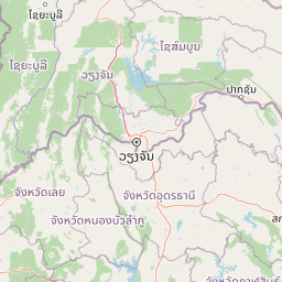
Map view of Nam Phouy National Biodiversity Conservation Area

Use this park location map to pinpoint Nam Phouy National Biodiversity Conservation Area in Laos, understand its exact geographic position, and read its mapped placement within the surrounding landscape more clearly.

Pigeon | © OpenStreetMap contributors

Location context for Nam Phouy National Biodiversity Conservation Area

Sayaboury Province
Park atlas

Compare regional mountain reserves and transboundary protected landscapes

Explore Parks Near Nam Phouy National Biodiversity Conservation Area

Browse other protected areas sharing the rugged terrain and montane forest habitats of the Luang Prabang Range. Continuing the geographic comparison reveals broader ecological patterns across the northwestern Laos border region.
National parkNan Province
About 44 km away#1 closest

West

Mae Charim National Park: Protected Landscape Identity and Nan Province Geography

Explore its mapped protected area and regional landscape context.

Mae Charim National Park is a vital national park situated in Nan Province, Thailand, contributing to the region's protected landscape atlas. This entry focuses on its specific geographic identity, mapped boundaries, and its role within the natural terrain of northern Thailand. Users can delve into the park's protected status and understand its spatial relationship to the surrounding geography, offering a concrete point for detailed map exploration.

Area
432 km²
Established
2007
IUCN
II
Visitors
10.1K annual
National parkNan Province
About 61 km away#2 closest

North

Khun Nan National Park: Explore its Mapped Protected Boundaries and Regional Geography

National park discovery in Nan Province, Thailand.

Khun Nan National Park is a significant protected area situated in the diverse geography of Nan Province, Thailand. As a national park, it offers critical insights into the region's natural landscapes and conservation efforts. Through an atlas-driven approach, users can explore its mapped boundaries, understand its position within the provincial geography, and gain a deeper appreciation for its role as a protected land.

Area
249 km²
Established
2009
IUCN
II
Visitors
2.6K annual
National parkNan Province
About 66 km away#3 closest

Southwest

Si Nan National Park: A Protected Landscape within Nan Province's Geography

Discover mapped boundaries and regional terrain context.

Delve into the geographic identity of Si Nan National Park, a protected national park situated in Thailand's Nan Province. This destination provides focused access for exploring its mapped boundaries and understanding its place within the broader regional geography. It serves as a critical point for discovering the natural landscape and protected-area details relevant to atlas and map-based research.

Area
1,024 km²
Established
2007
IUCN
II
Visitors
115.4K annual
National parkNan Province
About 67 km away#4 closest

Northwest

Doi Phu Kha National Park: National Park Protected Landscape and Geography in Nan Province

Explore mapped boundaries and natural terrain context.

Gain insight into Doi Phu Kha National Park, a protected national park situated in Nan Province, Thailand. This page offers a structured view of its geographic identity, mapped park boundaries, and the surrounding natural landscapes. It serves as a key point for understanding the park's role within Thailand's protected areas and its contribution to regional geographic context, ideal for atlas-based exploration.

Area
1,704 km²
Established
1999
IUCN
II
Visitors
63.1K annual
National parkThailand
About 111 km away#5 closest

Southwest

Lam Nam Nan National Park: Thailand's National Park Identity for Atlas Exploration

Explore the mapped geography and protected landscape of this Thai national park.

Lam Nam Nan National Park serves as a focal point for understanding Thailand's protected areas and their geographic distribution. This detail page facilitates atlas-style exploration, highlighting the park's specific landscape context and its mapped boundaries within the broader region. Users can gain insight into the protected natural terrain and its significance for regional geography and conservation landscape studies.

Area
999 km²
Established
1998
IUCN
II
Visitors
27.9K annual
National parkUttaradit Province
About 111 km away#6 closest

South

Phu Soi Dao National Park: A Protected Landscape within Uttaradit Province's Geography

Discover mapped terrain and protected area context.

Phu Soi Dao National Park is a designated national park offering valuable insights into Thailand's protected natural areas and regional geography. Explore the mapped boundaries and natural landscape context that define this significant protected territory within Uttaradit Province. This entry provides a foundation for understanding the park's role in conservation and its specific place within a broader geographic atlas.

Area
340 km²
Established
2008
IUCN
II
Visitors
19.7K annual
National parkUdon Thani Province
About 118 km away#7 closest

Southeast

Na Yung, Nam Som National Park: National Park Protected Landscape & Geography

Mapped boundaries and regional context within Udon Thani Province.

Explore the atlas-relevant geographic details of Na Yung, Nam Som National Park, a protected national park situated within Udon Thani Province. This focused view provides insight into the park's specific mapped boundaries and its role within the regional landscape context. Understand how this protected area contributes to the broader geography and serves as a key point for atlas-based discovery of Thailand's natural lands.

Area
397 km²
Established
1975
IUCN
II
Visitors
8.4K annual
Watercolor painting showing green mountains, a river, and trees in a natural landscape
National parkPhrae Province
About 125 km away#8 closest

West

Mae Yom National Park: Protected Mountain Forest and Yom River Geography

Discover its mapped boundaries and natural teak ecosystems.

Mae Yom National Park represents a significant protected landscape in Phrae Province, Thailand, characterized by its mountainous terrain and the prominent Yom River. This national park is particularly noteworthy for its naturally growing teak forests, offering a unique glimpse into indigenous timber ecosystems within a conservation area. The park's geography features steep ridges, tributary streams feeding the main river, and distinct landscapes like the Kaeng Sua Ten rapids, providing a rich atlas context for northern Thailand's protected areas and natural terrain.

Area
455 km²
Established
1986
IUCN
II
Visitors
6.7K annual

Common questions about visiting, size, designation, and location context for Nam Phouy National Biodiversity Conservation Area

Nam Phouy National Biodiversity Conservation Area FAQs for park facts, access, geography, and protected area context

Find quick answers about Nam Phouy National Biodiversity Conservation Area, including protected-area facts, park geography, trail and visitor context, and how the park fits into its surrounding country and regional landscape.
MoriAtlas Explorer

Continue Your Protected Areas Search Across the Global Atlas

Deepen your exploration by continuing the structured search for national parks and protected areas worldwide. Utilize the comprehensive filtering capabilities to compare different conservation landscapes and refine your understanding of global park geography. Discover more about the distribution and characteristics of protected natural areas.

Global natural geography