

Mori Atlas logo
National parkNameri National Park

Discover the mapped boundaries and natural terrain of this national park.

Nameri National Park: Protected Landscape Identity and Geographic Context in Sonitpur

(Nameri National Park & Tiger Reserve)

Nameri National Park, located within the Sonitpur region of India, stands as a key protected natural area. This page provides an atlas-centric view of Nameri National Park, focusing on its distinct landscape identity and its place within the regional geography. Users can explore its mapped boundaries and understand its role as a national park within the broader context of conservation landscapes.

Tiger ReserveNational ParkEastern HimalayasAssamNortheast IndiaRiparian Forests

Nameri National Park

National park

Park overview

Structured park overview, official facts, and landscape profile for Nameri National Park

Nameri National Park park facts, protected area profile, and essential visitor context
Review the core facts for Nameri National Park, including designation, size, terrain, visitor scale, habitats, and operating context in one park-focused overview.

About Nameri National Park

Nameri National Park occupies a strategic position in the biogeographic landscape of northeastern India, representing a crucial corridor for wildlife movement between the Himalayan foothills and the Brahmaputra valley. The park's terrain comprises gentle undulating hills, river valleys, and extensive flat areas interspersed with numerous water bodies, creating a mosaic of habitats that support remarkable biodiversity. The ecosystem derives its character from the Jia-Bharali River system, which not only provides critical aquatic habitat but also shapes the surrounding landscape through seasonal flooding that maintains fertile grasslands and wetland areas. Beyond its ecological significance, Nameri serves as an important buffer zone between human settlements and the more remote wilderness areas of Arunachal Pradesh, with approximately 3,000 head of cattle currently grazing within the forest boundaries. The park's management balances conservation objectives with the livelihood needs of local communities, though this integration presents ongoing challenges particularly regarding human-wildlife conflict. The transboundary nature of the larger protected landscape, connecting Nameri with Pakhui Wildlife Sanctuary, enables species movement across a broader area than either individual protected area could support alone.

Quick facts and research context for Nameri National Park

Nameri National Park spans approximately 200 square kilometers in the eastern Himalayan foothills of Assam's Sonitpur District. The park shares its northern boundary with Pakhui Wildlife Sanctuary in Arunachal Pradesh, and together these protected areas form a contiguous zone exceeding 1,000 square kilometers. The Jia-Bharali River flows along the southern boundary, while the Bor-Dikorai tributary drains the eastern sections. The park was declared a Tiger Reserve in 2000, marking it as the second tiger reserve in Assam. Over 600 floral species and 374 recorded bird species contribute to the area's biodiversity, which includes populations of Bengal tigers, Indian elephants, and numerous hornbill species.

Park context

Deeper park guide and search-rich context for Nameri National Park

Nameri National Park history, landscape, wildlife, and travel context
Explore Nameri National Park through its history, landscape character, ecosystems, wildlife, conservation priorities, cultural context, and seasonal travel timing in a structured park guide built for atlas discovery and search intent.

Why Nameri National Park stands out

Nameri National Park is best known for its tiger population and status as a designated Tiger Reserve, supporting breeding populations of Bengal tigers within its diverse Himalayan foothill ecosystem. The park is equally renowned for its exceptional avifauna, particularly the white-winged wood duck, which is among the rarest waterfowl in Asia, along with multiple species of hornbills including the great pied hornbill, wreathed hornbill, and rufous-necked hornbill. The Jia-Bharali River historically supported golden mahseer fishing, a tradition dating to British colonial times, though angling was officially banned in 2011. The park's location along a major bird migration route and its diverse habitats ranging from semi-evergreen forests to riverine grasslands make it a significant destination for wildlife enthusiasts and researchers alike.

Nameri National Park history and protected-area timeline

Nameri National Park's journey to protected status began in 1978 when the area was declared a reserve forest on October 17 of that year. Prior to formal protection, the forest was subject to significant logging activity that altered its composition and density. The area was formally established as the Nameri Sanctuary on September 18, 1985, with an initial area of 137 square kilometers as part of the larger Naduar Forest Reserve. This designation provided the first formal wildlife protection framework for the region. A significant expansion occurred on November 15, 1998, when an additional 75 square kilometers were incorporated, formally establishing Nameri as a National Park. The year 2000 marked a pivotal moment in the park's conservation history when it was declared the second Tiger Reserve in Assam, following Manas Tiger Reserve, elevating its conservation status and bringing additional resources for habitat protection and species monitoring. The park operates under the governance of the Ministry of Environment and Forests and the Government of India.

Nameri National Park landscape and geographic character

The physical landscape of Nameri National Park reflects its position at the interface between the Himalayan mountain system and the alluvial plains of the Brahmaputra valley. The terrain consists primarily of gentle slopes and undulating hills that transition into flat river valleys, with elevations varying across the park's extent. The Jia-Bharali River, flowing from northwest to southeast along the southern boundary, forms the most significant watercourse and has carved a broad valley that supports distinct riparian ecosystems. In the eastern sections, the Bor-Dikorai River and its tributaries drain the landscape, adding complexity to the hydrological system. The river corridors are flanked by extensive semi-evergreen and moist deciduous forests, while the flatter areas support grasslands and marshy zones that provide critical habitat for multiple species. The overall landscape character is one of moderate relief with dense vegetation cover, though forest coverage has declined to between 30 and 40 percent in recent decades due to various pressures.

Nameri National Park ecosystems, habitats, and plant life

The ecological character of Nameri National Park is defined by its position within the Himalayan biogeographic zone, supporting a blend of species from both Himalayan and Indo-Burmese regions. The park's flora encompasses over 600 species, including valuable timber species such as Gmelina arborea and Michelia champaca, as well as culturally significant plants like agarwood and Rudraksha. The forest composition varies from semi-evergreen to moist deciduous, with bamboo groves interspersed throughout. Orchids represent a particularly notable floral group, with species from genera including Dendrobium, Cymbidium, and Cypripedioideae documented within the park boundaries. The river systems support aquatic vegetation and provide critical habitat for fish species, while the riparian zones host distinct plant communities adapted to seasonal flooding. The diverse habitat mosaic, combining forest, grassland, and wetland ecosystems, creates the conditions for remarkable biodiversity at multiple trophic levels.

Nameri National Park wildlife and species highlights

Nameri National Park supports a remarkable assemblage of mammalian species, with the Bengal tiger and Indian elephant representing the most iconic inhabitants. The predator community includes the Bengal tiger, Indian leopard, clouded leopard, marbled cat, and leopard cat, reflecting the park's importance as a carnivore stronghold in northeastern India. Ungulate species such as sambar, hog deer, barking deer, and gaur form important prey bases and are commonly observed throughout the park. The park also supports significant populations of primates, including the capped langur, and arboreal mammals such as the Indian giant squirrel. Herbivores including wild boar and bears such as sloth bear and Himalayan black bear complete the mammalian community. The avifauna is particularly diverse, with 374 bird species recorded in 2005 including the endangered white-winged wood duck, multiple hornbill species, black stork, and ibisbill. The river systems historically supported golden mahseer, a prized game fish, though populations have declined following the 2011 fishing ban.

Nameri National Park conservation status and protection priorities

Nameri National Park occupies a critical position in India's conservation framework, particularly as a designated Tiger Reserve that contributes to the country's goal of maintaining viable tiger populations across connected habitats. The park's transboundary designation as part of a larger ecological unit with Pakhui Wildlife Sanctuary in Arunachal Pradesh enables species movement across state boundaries, which is essential for maintaining genetic connectivity in a region where habitat fragmentation is an increasing concern. However, the park faces significant conservation challenges. Ongoing official logging activities in the Sonitpur region continue to place pressure on the ecosystem, while forest cover decline to below 30-40 percent has intensified human-wildlife conflict. Elephant populations periodically raid crops and damage property, leading to retaliatory actions that threaten both human and animal lives. The presence of approximately 3,000 cattle grazing within the park boundaries further degrades habitat quality and creates disease transmission risks to wild populations. Conservation efforts must balance these competing pressures while maintaining the park's critical role in protecting Himalayan foothill biodiversity.

Nameri National Park cultural meaning and human context

The landscape surrounding Nameri National Park has been inhabited by local communities for generations, with the park boundary lying approximately 9 kilometers from Chariduar, the nearest village. Traditional land use practices including grazing, collection of forest products, and small-scale agriculture have shaped the human-environment relationship in this region. The cultural landscape includes references to indigenous communities who have historically relied on the forest for livelihood resources including timber, non-timber forest products, and traditional medicines. The park's proximity to Tezpur, the nearest major city approximately 35 kilometers away, means that the local economy is influenced by both agricultural activities and the potential for nature-based tourism. The continuing presence of cattle grazing within park boundaries reflects the complex relationship between local livelihoods and conservation objectives, a challenge common to many Indian protected areas.

Top sights and standout views in Nameri National Park

Nameri National Park offers exceptional wildlife viewing opportunities within its role as Assam's second Tiger Reserve, where visitors may encounter Bengal tigers, leopards, and clouded leopards in the dense forest habitats. The white-winged wood duck, among Asia's rarest waterfowl, inhabits the park's wetland areas and represents a major draw for ornithologists. The great pied hornbill and other hornbill species can be observed in the canopy, particularly during the breeding season when their loud calls echo through the forest. River-based activities along the Jia-Bharali provide opportunities to experience the aquatic dimension of the ecosystem, though fishing is now restricted. The park's position at the edge of the Himalayas provides a scenic backdrop of forested slopes and river valleys that distinguishes it from the more lowland protected areas of Assam.

Best time to visit Nameri National Park

The optimal period for visiting Nameri National Park spans from November through April, when the post-monsoon weather brings clearer skies and reduced humidity to the Himalayan foothills. This season corresponds with the dry period when wildlife becomes more concentrated around remaining water sources, improving sighting opportunities for large mammals including elephants and tigers. The winter months from December to February can bring foggy conditions in early mornings, though this atmospheric quality creates distinctive photographic opportunities in the river valleys. The summer months from May to June offer warm conditions but may provide good wildlife viewing as animals seek water along the rivers. The monsoon season from July to October brings heavy rainfall that can restrict park access and make certain areas difficult to traverse, though the lush green landscapes and full river flow showcase the ecosystem at its most vibrant.
Park location guide

Geography guide, regional context, and park location map for Nameri National Park

Nameri National Park park geography, regions, and map view in India
Understand where Nameri National Park sits in India through a broader geographic reading of the surrounding landscape, nearby location context, and its mapped position within the national park landscape.

How Nameri National Park fits into India

India is a South Asian country bordered by the Indian Ocean, Arabian Sea, and Bay of Bengal. It shares land borders with Pakistan, China, Nepal, Bhutan, Bangladesh, and Myanmar. The country has a population of over 1.4 billion people and operates as a federal parliamentary republic with its capital in New Delhi.

Wider geography shaping Nameri National Park in India

India occupies the Indian subcontinent in South Asia, bordered by the Arabian Sea to the southwest, the Bay of Bengal to the southeast, and the Indian Ocean to the south. It shares land borders with Pakistan to the west, China, Nepal, and Bhutan to the north, and Bangladesh and Myanmar to the east. The territory also includes the Andaman and Nicobar Islands in the Indian Ocean.

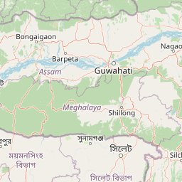
Map view of Nameri National Park

Use this park location map to pinpoint Nameri National Park in India, understand its exact geographic position, and read its mapped placement within the surrounding landscape more clearly.

Pigeon | © OpenStreetMap contributors

Location context for Nameri National Park

AssamSonitpur
Park atlas

Discover surrounding conservation landscapes and regional park geography across Assam and its adjacent states.

Explore National Parks and Protected Areas Near Nameri National Park in the Eastern Himalayas
Explore other national parks and protected areas situated within or adjacent to the Eastern Himalayan foothills, expanding your geographic understanding beyond Nameri National Park's boundaries. Compare diverse conservation landscapes, riverine ecosystems, and varied terrains across Assam and surrounding regions, tracing connections among India's significant natural reserves.
Watercolor painting of green hills, fields, and a body of water
National parkAssam

Kaziranga National Park National Park: Protected Landscape and Geographic Atlas

Mapped boundaries and regional landscape context for this Assam natural area.

Delve into the detailed geographic profile of Kaziranga National Park, a prominent National Park located in Assam, India. This section focuses on its mapped protected area extent, its unique landscape characteristics within the Brahmaputra valley, and its role as a key natural landmark in northeastern India's atlas. Understand the structured geographic data and protected land identity that makes Kaziranga National Park a distinct entity for exploration.

Area
1,090 km²
Established
1905
IUCN
II
Relief
Lowland
National parkAssam

Orang National Park: Assam's Key Floodplain Protected Landscape

Explore mapped boundaries and terrain context of this national park.

Orang National Park, located in Assam, India, is a significant protected area celebrated for its unique alluvial floodplain terrain and critical role in conservation. This national park provides a focused atlas-style view of grassland and wetland ecosystems, essential habitats for iconic species like the great Indian one-horned rhinoceros and Bengal tiger. Its geographical setting along the Brahmaputra River contributes to a dynamic landscape, offering rich context for understanding protected area distribution and regional natural features. Discover the mapped boundaries and ecological significance of this important protected land.

Area
78.81 km²
Established
1985
IUCN
II
Relief
Lowland
Wildlife reserveTrashigang District

Sakteng Wildlife Sanctuary: Protected Area and Wildlife Reserve in Bhutan's Trashigang District

Mapping the mountainous terrain and unique temperate ecosystems.

Sakteng Wildlife Sanctuary is a vital protected area in eastern Bhutan, recognized as a wildlife reserve. Spanning approximately 742 square kilometers within Trashigang District, it features a dramatic mountainous terrain characterized by steep valleys and alpine meadows. The sanctuary's landscape transitions from forested slopes to subalpine conifer forests, representing Bhutan's easternmost temperate ecosystems and offering rich geographic context for atlas exploration.

Area
742.46 km²
Established
2003
IUCN
IV
Relief
Mountain
Wildlife reserveTrashiyangtse District

Bumdeling Wildlife Sanctuary: Bhutan Wildlife Reserve with Mapped Protected Boundaries

Explore its regional geography and natural landscape context.

Bumdeling Wildlife Sanctuary is a designated wildlife reserve located in Bhutan's Trashiyangtse District. This page provides detailed atlas-style information on its protected landscape, including its geographic positioning and mapped boundaries. Understand how this reserve contributes to the regional geography and serves as a crucial element of Bhutan's protected areas.

Area
1,520.61 km²
Established
1998
Relief
Mountain
Access
Access unknown
National parkBhutan

Phrumsengla National Park: Protected Landscape and Geographic Context in Bhutan

Explore mapped boundaries and diverse Himalayan terrain.

Phrumsengla National Park serves as a vital protected area within Bhutan, characterized by its extensive altitudinal range and varied landscape. Spanning from subtropical valleys to alpine zones, the park showcases a remarkable transition of ecosystems, including significant old-growth fir forests. Its location and unique geographic features make it an important component of any study of the region's protected lands and Himalayan geography, offering rich data for atlas exploration and understanding natural landscapes.

Area
905.05 km²
Established
1998
IUCN
II
Relief
Mountain
National parkAssam

Manas National Park: Assam's National Park Protected Landscape and Geographic Atlas

Explore mapped boundaries and regional landscape context.

Manas National Park offers a distinct protected landscape within the state of Assam, India. This national park is a key feature in the geography of the Brahmaputra River valley, providing valuable context for atlas-driven exploration. Understand its mapped territory and regional setting as a protected natural area.

Area
850 km²
Established
1990
IUCN
II
Relief
Mountain
National parkBhutan

Wangchuck Centennial National Park: Bhutan National Park Protected Landscape

Mapped geographic context and park identity in the Eastern Himalayas.

Wangchuck Centennial National Park stands as a protected national park within Bhutan, offering a detailed look at its geographic distribution and landscape characteristics. This page provides essential atlas-level information about its mapped boundaries and its significance as a protected area in the South Asian region.

Area
4,914 km²
Established
2008
IUCN
II
Relief
Mountain
National parkTrongsa District

Jigme Singye Wangchuck National Park: Bhutan National Park's Geographic and Landscape Atlas

Mapped protected area within Trongsa District's natural terrain.

Delve into the detailed geographic identity of Jigme Singye Wangchuck National Park, a protected national park situated in Bhutan's Trongsa District. This park provides essential context for understanding Bhutanese geography and conservation landscapes. Examine its mapped boundaries and place within the regional terrain, offering a structured exploration for anyone interested in national park geography and protected natural areas.

Area
1,730 km²
Established
1995
IUCN
II
Relief
Mountain

Common questions about visiting, size, designation, and location context for Nameri National Park

Nameri National Park FAQs for park facts, access, geography, and protected area context
Find quick answers about Nameri National Park, including protected-area facts, park geography, trail and visitor context, and how the park fits into its surrounding country and regional landscape.
MoriAtlas Explorer

Continue Your Protected Areas Search Across the Global Atlas

Deepen your exploration by continuing the structured search for national parks and protected areas worldwide. Utilize the comprehensive filtering capabilities to compare different conservation landscapes and refine your understanding of global park geography. Discover more about the distribution and characteristics of protected natural areas.

Global natural geography
