
Mori Atlas logo
Protected areaNatura 2000-område nr. 52 Salten Å, Salten Langsø, Mossø og søer syd for Salten Langsø og dele af Gudenå

Tracing the mapped boundaries of Jutland's most significant river valley and freshwater lake corridor.

Natura 2000-område nr. 52 Salten Å, Salten Langsø, Mossø: A Protected Landscape in Central Denmark

Natura 2000-område nr. 52 encompasses a substantial network of freshwater, wetland, and woodland habitats within the Midtjyske Søhøjland. This protected area centers on the Salten Å valley, the deep waters of Salten Langsø, and Mossø, which stands as the largest lake in Jutland. The terrain features a complex mosaic of glacial river valleys, nutrient-poor sandy ridges, raised bogs, and Atlantic beech forests that support diverse protected species and habitats.

Lake districtFreshwater habitatsMire and bogHeathlandBeech forestRiver valley
Stylized flat-vector illustration of a river valley with waterfalls cascading down cliffs, surrounded by pine and deciduous trees and mountains in the background.

Natura 2000-område nr. 52 Salten Å, Salten Langsø, Mossø og søer syd for Salten Langsø og dele af Gudenå

Protected area

Park overview

Structured park overview, official facts, and landscape profile for Natura 2000 Area No. 52: Salten Å, Salten Langsø, Mossø

Natura 2000 Area No. 52: Salten Å, Salten Langsø, Mossø park facts, protected area profile, and essential visitor context

Review the core facts for Natura 2000 Area No. 52: Salten Å, Salten Langsø, Mossø, including designation, size, terrain, visitor scale, habitats, and operating context in one park-focused overview.

About Natura 2000 Area No. 52: Salten Å, Salten Langsø, Mossø

Natura 2000 Area No. 52 is a large European habitat site located in the heart of the Midtjyske Søhøjland, a glacially formed lake and river landscape in central Jutland. Designated under the EU Habitats Directive as site H48, the area covers around 4,470 hectares and stretches across parts of Silkeborg, Skanderborg, and Horsens municipalities. Its boundaries trace a coherent ecological corridor rather than a single landform, linking lakes, river valleys, mires, heaths, and forest patches into one protected unit.

At the core of the area are three large lakes: Salten Langsø, Mossø, and Gudensø. Mossø is Jutland's largest lake and forms the eastern anchor of the site, while Salten Langsø is a long, narrow lake occupying the Salten Å valley to the west. Together with the river Salten Å, which flows east into the Gudenå between Mossø and Gudensø, these waters define the area's hydrological backbone. Smaller lakes and water bodies south of Salten Langsø extend the freshwater character further, while a stretch of the Gudenå between Voervadsbro and Gudensø adds a major lowland river element.

Ecologically, the area stands out for the sheer breadth of habitat types it contains. The lakes represent several distinct nutrient and alkalinity regimes, from clear Lobelia and charophyte lakes to nutrient-rich and brown-water lakes. Surrounding dry sandy soils north and south of Salten Langsø support extensive areas of wet and dry heath, while wetter depressions are rich in raised bogs, hanging peat mats, reed marshes, lime-rich fens, and spring mires. Forest cover includes Atlantic beech woodland on peat with holly, beech on mull soils, and alder-ash swamp forest along the river valleys.

The area also has cultural and land-use history. Large parts of the site have been shaped by traditional grazing, peat cutting, and forestry practices, and old estates such as Vissingkloster and the area around Klostermølle mark the intersection of cultural and natural heritage. Today the site functions simultaneously as an EU habitat area, a bird protection area, and a national conservation priority, managed through Natura 2000 plans coordinated with regional water plans.

Quick facts and research context for Natura 2000 Area No. 52: Salten Å, Salten Langsø, Mossø

Natura 2000 Area No. 52 is an EU habitat area (code H48) located in Region Midtjylland in central Jutland, Denmark. It spans parts of Silkeborg, Skanderborg, and Horsens municipalities and covers approximately 4,470 hectares, of which 178 hectares are state-owned. The site also overlaps with bird protection areas F33 and F35.

The area lies within the Midtjyske Søhøjland and includes Salten Å, Salten Langsø, Mossø, lakes south of Salten Langsø, and a stretch of the Gudenå river. Roughly 69 percent of the total area is covered by habitats protected under the Danish Nature Protection Act. The Natura 2000 plan for the site was adopted in 2011 and has been continued and refined in subsequent planning periods.

Park context

Deeper park guide and search-rich context for Natura 2000 Area No. 52: Salten Å, Salten Langsø, Mossø

Natura 2000 Area No. 52: Salten Å, Salten Langsø, Mossø history, landscape, wildlife, and travel context

Explore Natura 2000 Area No. 52: Salten Å, Salten Langsø, Mossø through its history, landscape character, ecosystems, wildlife, conservation priorities, cultural context, and seasonal travel timing in a structured park guide built for atlas discovery and search intent.

Why Natura 2000 Area No. 52: Salten Å, Salten Langsø, Mossø stands out

Natura 2000 Area No. 52 is best known for protecting a remarkable concentration of freshwater habitats in central Jutland, anchored by Mossø, the largest lake in Jutland, and the elongated Salten Langsø. Together with the Salten Å river valley and a section of the Gudenå, these waters form one of Denmark's most intact lake-and-river landscapes. The site is also distinguished by the diversity of protected habitat types within a relatively compact area. Lobelia lakes, charophyte lakes, nutrient-rich and brown-water lakes, raised bogs, spring mires, fens, wet and dry heaths, juniper scrub, and Atlantic beech forest on peat with holly all occur here. This combination of lake, mire, heath, and forest habitats, paired with protected fauna such as the otter and large crested newt, gives the area a distinctive and ecologically rich character unusual even within Denmark's broader Natura 2000 network.
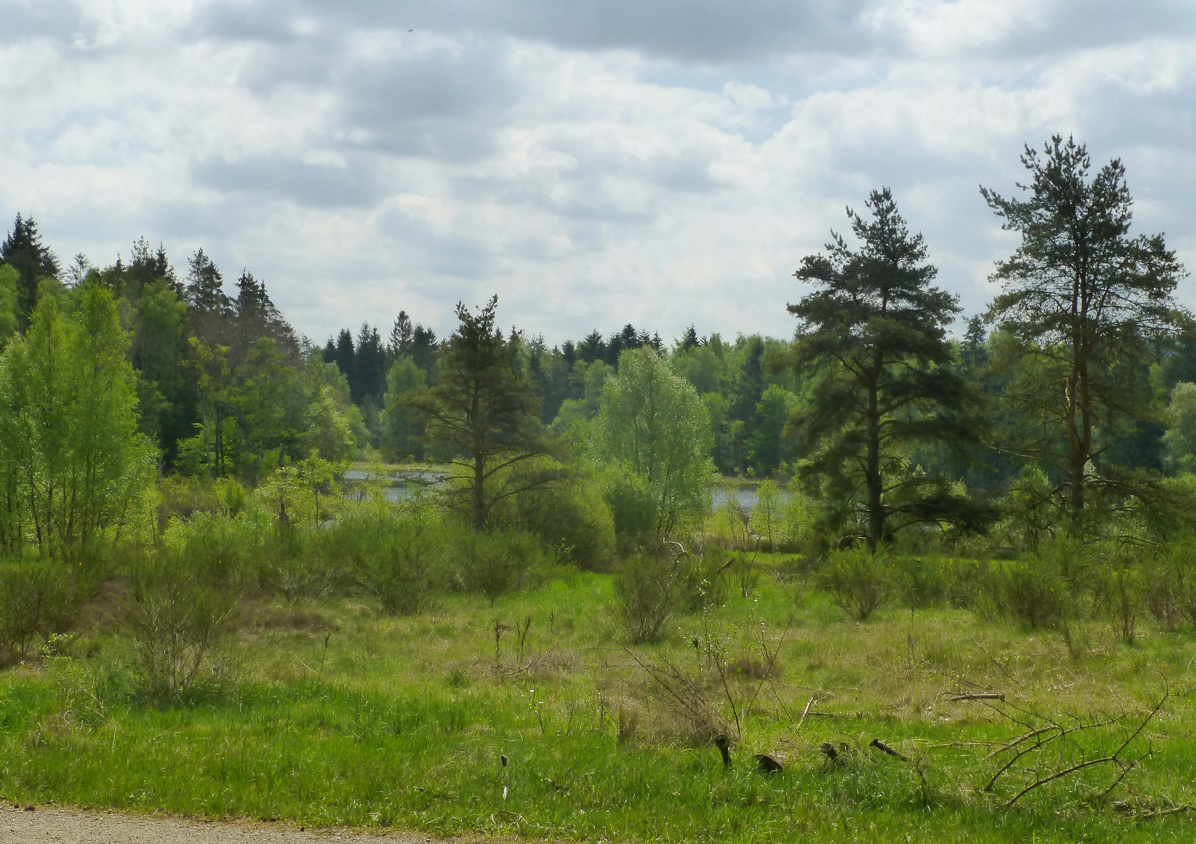
A landscape view of a grassy meadow leading into a mixed forest of pine and deciduous trees under a cloudy sky with a marshy area visible in the distance.
Addit Forest landscape near Svinesø showing the transition from meadow to mixed woodland under a cloudy sky.

Natura 2000 Area No. 52: Salten Å, Salten Langsø, Mossø history and protected-area timeline

The natural landscapes that now make up Natura 2000 Area No. 52 have a long history of low-intensity human use. Along the Gudenå near Mossø, the historic Vissingkloster estate has shaped land management for centuries, and a nature conservation order dating to 1984 protects the area around Klostermølle as part of the site's cultural-natural heritage. Traditional land uses such as grazing, haymaking, peat cutting, and selective forestry have helped maintain the open mires, heaths, and meadows that still characterize the area.

Seven site-specific nature conservation orders cover parts of the current Natura 2000 area. These include the protection of Mossø and its surroundings, areas around Salten Langsø, areas along Salten Å, the Salten Å valley and Snabegård Plantage, Vissingkloster, the Gudenå valley and Pinddal Mose, and smaller parcels near Hangarhus south-east of Salten Langsø. Together these orders laid the groundwork for stricter, ecosystem-level protection.

The site's modern identity dates to Denmark's Natura 2000 designation, when it was classified as EU habitat area H48. The first Natura 2000 plan for the area was adopted in 2011, after which municipalities and the Danish Nature Agency developed binding action plans to implement conservation measures. Subsequent planning periods have continued and refined these efforts, with the plan coordinated with the Randers Fjord water plan to integrate habitat and water management goals across the Gudenå catchment.

Natura 2000 Area No. 52: Salten Å, Salten Langsø, Mossø landscape and geographic character

Natura 2000 Area No. 52 sits within the Midtjyske Søhøjland, a landscape shaped by glacial meltwater that carved the deep, west-to-east running Salten Å valley and created several of Jutland's largest lakes. The terrain combines steep valley sides, flat lake basins, gently undulating sandy ridges, and level mire plains, producing a varied topography within a relatively compact area.

The Salten Å valley forms the western spine of the site. The slender Salten Langsø fills much of the valley floor, flanked by forested slopes such as Addit Skov on the southern side. East of the lake, Salten Å continues into the broader Gudenå valley, merging with Mossø, the largest and shallowest of the major lakes in the area. To the south, extensive flat mires and wet meadows extend along the Gudenå, including areas near Springbjerg Mose and Klosterkæret, where the river enters Mossø at Vissingkloster.

Coarse sandy soils north and south of Salten Langsø support a different landscape character, dominated by open heath, juniper scrub, and patches of dry grassland. The mix of lakes, river valleys, mires, heath ridges, and beech forest gives the area a striking visual diversity. It is regarded as one of Denmark's least disturbed natural landscapes, where large-scale ecological patterns remain largely intact.
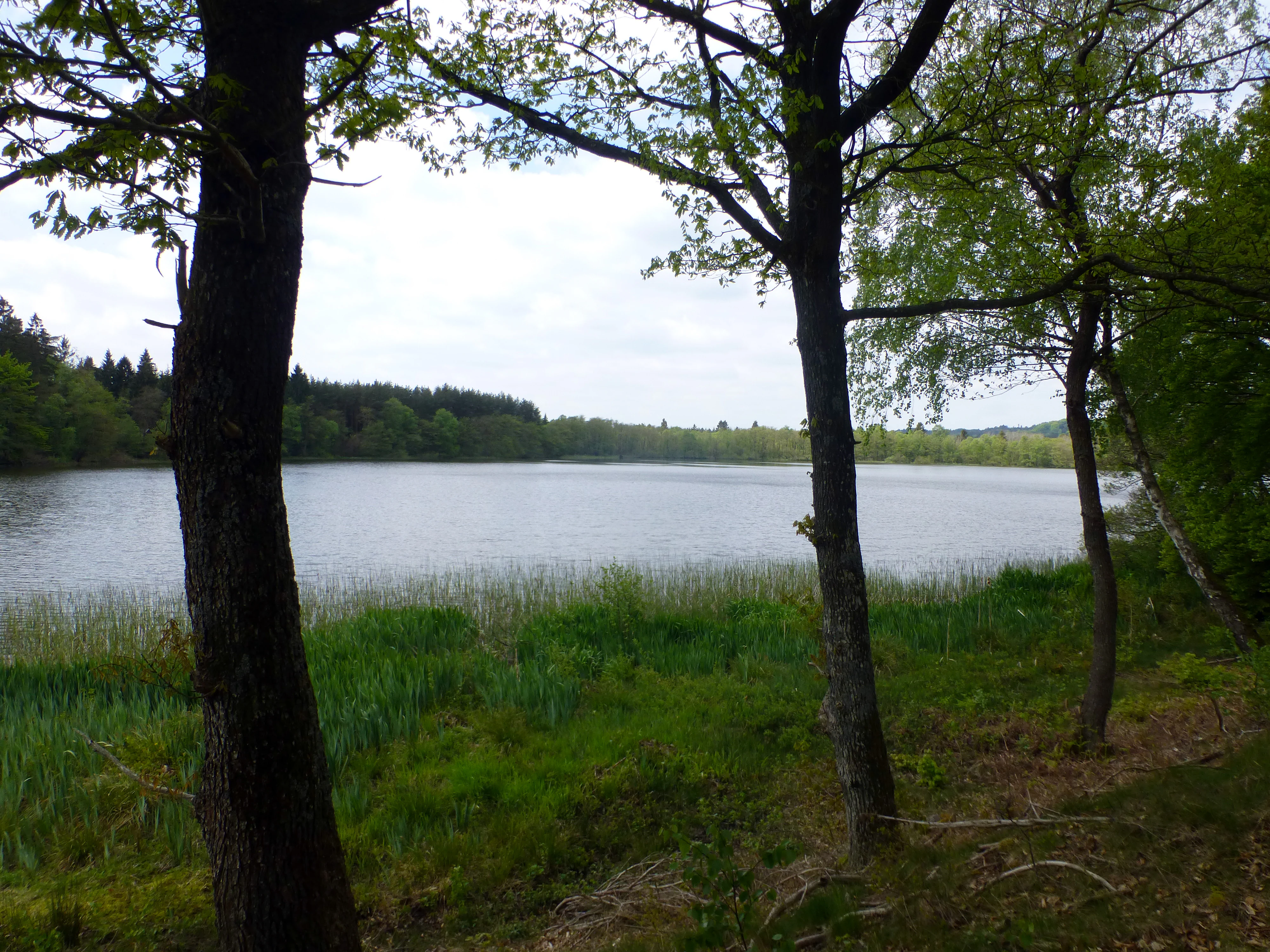
A view of Salten Langsø lake framed by tree trunks in the foreground, with green reeds along the shoreline and a forested opposite bank under an overcast sky
The southwest end of Salten Langsø viewed from Addit Naes

Natura 2000 Area No. 52: Salten Å, Salten Langsø, Mossø ecosystems, habitats, and plant life

The natural value of Natura 2000 Area No. 52 lies in its combination of freshwater systems and surrounding terrestrial habitats. The lakes range from clear, nutrient-poor systems dominated by Lobelia and charophyte algae to more nutrient-rich lakes and brown-water lakes draining peat-rich catchments. This variation in water chemistry supports distinct aquatic plant communities and creates habitat for fish, invertebrates, and water birds with different ecological requirements.

The terrestrial side of the area mirrors this diversity. Large raised bogs, hanging peat mats, sedge marshes, and spring-fed fens represent the wetter end of the habitat spectrum, supporting rare mosses, lichens, and plant species tied to open, calcareous, and nutrient-poor conditions. Dry sandy areas support extensive wet and dry heath, acid grassland, juniper scrub, and small areas of dry grassland on acidic soils.

Forests are also an important component. Along the lake and river valleys, alder-ash swamp forest thrives on wet, nutrient-rich soils, while hilltops and valley sides carry Atlantic beech forest communities. Particularly notable are the stands of beech growing on peat with holly, an exceptionally rare woodland type within the EU Habitats Directive. Smaller parcels are managed specifically as biodiversity forest to protect fungi and mosses associated with wet, open habitats.

Natura 2000 Area No. 52: Salten Å, Salten Langsø, Mossø wildlife and species highlights

The combination of large lakes, mires, and mature forest makes Natura 2000 Area No. 52 important for a wide range of species. Among mammals, the otter is one of the area's most significant conservation targets, reflecting the cleanliness and connectivity of the river and lake systems. The large crested newt and the eastern water bat, another characteristic pond bat, both occur here, also tied to the network of smaller lakes, ponds, and wet woodland.

Birds are a major reason the site is protected. Salten Langsø supports breeding fish-eating birds such as osprey and white-tailed eagle, while the surrounding forests harbor black woodpecker and eagle owl. Kingfisher, listed for both bird protection areas within the site, occurs along the clear streams of the Salten Å and Gudenå. Marshes around Mossø and the Gudenå support marsh harrier and a rich community of water birds.

In the rivers and lakes, brook lamprey reflects good water quality, while the protected diving beetle species listed in the site designation, including the rare bright diving beetle, indicates the presence of well-preserved aquatic invertebrate communities. The overall wildlife character of the area combines top predators with specialist aquatic and forest species, giving it a strong conservation profile beyond typical lowland lake districts.

Natura 2000 Area No. 52: Salten Å, Salten Langsø, Mossø conservation status and protection priorities

Natura 2000 Area No. 52 is protected primarily because of the extraordinary concentration of habitat types and species it contains within a relatively compact area. It is one of Denmark's key EU habitat sites, and a substantial portion of its area is also covered by national § 3 habitat protection under the Danish Nature Protection Act, which safeguards heaths, mires, meadows, lakes, and watercourses regardless of Natura 2000 status.

The conservation picture is reinforced by seven overlapping nature conservation orders, which protect specific parcels around Mossø, Salten Langsø, Salten Å, the upper Salten Å valley, Vissingkloster, the Gudenå valley, and smaller areas south-east of Salten Langsø. Together these orders create a layered protection regime combining European, national, and local instruments.

Active conservation measures are also in place. Around 10 hectares near Odderholm between Gudensø and Mossø have been set aside as biodiversity forest to protect rare fungi and mosses tied to wet, open habitats, while a further 11 hectares near Klostermølle have been designated as new biodiversity forest under the older 1984 Vissingkloster protection order. The Natura 2000 plan adopted in 2011, coordinated with the Randers Fjord water plan, ensures that habitat management and water management work together across the catchment.

Natura 2000 Area No. 52: Salten Å, Salten Langsø, Mossø cultural meaning and human context

The landscape of Natura 2000 Area No. 52 carries visible traces of its long human history. The Vissingkloster estate, near the outlet of the Gudenå into Mossø, has shaped land use around the western end of Mossø for centuries, and the nearby Klostermølle area reflects the mixing of monastic, industrial, and agricultural traditions. Open mires and meadows south of the Gudenå, including areas like Springbjerg Mose and Klosterkæret, are largely products of traditional grazing and haymaking practices that have preserved open, species-rich conditions.

Forestry has also left its mark, with conifer plantations like Snabegård Plantage and deciduous woodlands such as Addit Skov representing different eras of forest management. Today, several of these forests are being reshaped toward more natural, biodiverse forest types, linking cultural heritage with modern conservation goals.

Top sights and standout views in Natura 2000 Area No. 52: Salten Å, Salten Langsø, Mossø

The defining strength of Natura 2000 Area No. 52 is the way it bundles several rare habitat types around a single hydrological axis. Mossø, Salten Langsø, and the connecting Salten Å and Gudenå together support an exceptional sequence of lake types, from Lobelia lakes and charophyte lakes to nutrient-rich and brown-water lakes, all within one Natura 2000 boundary.

Equally distinctive is the surrounding terrestrial habitat mosaic. Raised bogs, hanging peat mats, calcareous fens, spring mires, acid and alkaline wet heaths, dry heaths on sandy soils, and Atlantic beech woodlands on peat with holly occur together across the area. Protecting species such as the otter, large crested newt, pond bat, and brook lamprey, alongside breeding ospreys and white-tailed eagles, makes this site a key reference point for European freshwater and mire conservation in Denmark.

Best time to visit Natura 2000 Area No. 52: Salten Å, Salten Langsø, Mossø

Spring and early summer are generally the most rewarding periods to experience the character of Natura 2000 Area No. 52. As water levels stabilize, reed beds fill with breeding marsh harriers and water birds, deciduous woodlands leaf out, and heath areas begin to show fresh green growth. Early mornings during this season offer the best chances to see fishing ospreys, hunting white-tailed eagles over the larger lakes, and secretive species along the river margins.

Late summer and early autumn bring a quieter, warmer atmosphere suitable for observing dragonflies along the mires and shallow lake edges, as well as fungi in the biodiversity forest areas around Odderholm and Klostermølle. Winter can be harsh, but crisp conditions often provide excellent visibility across the open lake surfaces and heath ridges, with migratory and wintering waterfowl concentrated on the larger lakes.

Monthly climate preview

Long-term temperatures rise into midyear while precipitation continues year-round

Salten Å, Salten Langsø, and Mossø monthly climate pattern record

At the representative coordinate for Natura 2000 area 52, 1991–2020 mean temperatures rise from about 1°C early in the year to around 17°C near midyear before declining. Daily precipitation averages remain present in every month, and the complete climate profile adds minimum and maximum temperatures for a fuller comparison.
Annual mean8 °C
1 °C17 °C
Jan
Feb
Mar
Apr
May11°
Jun14°
Jul17°
Aug17°
Sep13°
Oct
Nov
Dec
Warmest month
July

16.7 °C

Coolest month
February

0.9 °C

Wettest month
October

2.7 mm/day

Driest month
April

1.5 mm/day

Park location guide

Geography guide, regional context, and park location map for Natura 2000 Area No. 52: Salten Å, Salten Langsø, Mossø

Natura 2000 Area No. 52: Salten Å, Salten Langsø, Mossø park geography, regions, and map view in Denmark

Understand where Natura 2000 Area No. 52: Salten Å, Salten Langsø, Mossø sits in Denmark through a broader geographic reading of the surrounding landscape, nearby location context, and its mapped position within the national park landscape.

How Natura 2000 Area No. 52: Salten Å, Salten Langsø, Mossø fits into Denmark

Denmark is a constitutional monarchy and Nordic country in Northern Europe. It is the southernmost of the Scandinavian countries, bordering Germany to the south, Norway to the north, and Sweden to the southwest. The country consists of the Jutland peninsula and an archipelago of islands, with Copenhagen as its capital and largest city. Denmark has a population of over 6 million and is characterized by flat, arable land, sandy coasts, and a temperate climate.

Wider geography shaping Natura 2000 Area No. 52: Salten Å, Salten Langsø, Mossø in Denmark

Denmark occupies the Jutland peninsula and roughly 406 islands in Northern Europe. It is situated between the North Sea to the west and the Baltic Sea to the east. The country borders Germany to the south and is connected to Sweden via the Øresund Bridge. Denmark is predominantly flat terrain with low elevation, the highest point being Møllehøj at 170.86 meters.

Map view of Natura 2000 Area No. 52: Salten Å, Salten Langsø, Mossø

Use this park location map to pinpoint Natura 2000 Area No. 52: Salten Å, Salten Langsø, Mossø in Denmark, understand its exact geographic position, and read its mapped placement within the surrounding landscape more clearly.

Pigeon | © OpenStreetMap contributors

Location context for Natura 2000 Area No. 52: Salten Å, Salten Langsø, Mossø

Central Denmark Region

Visual exploration of freshwater habitats, glacial river valleys, and protected terrain across central Jutland

Natura 2000-område nr. 52 Salten Å, Salten Langsø, Mossø og søer syd for Salten Langsø og dele af Gudenå Photos and Landscape Scenery

Photographic records illustrate the complex topography of glacial river valleys, expansive lakes, and diverse woodland habitats within Natura 2000-område nr. 52 Salten Å, Salten Langsø, Mossø og søer syd for Salten Langsø og dele af Gudenå. Visual documentation helps researchers evaluate protected landscape characteristics, terrain variations, and rare ecological communities across the protected area.

A landscape view of a grassy meadow leading into a mixed forest of pine and deciduous trees under a cloudy sky with a marshy area visible in the distance.

A landscape view of a large lake with a cluster of green trees on the left bank, grassy foreground, and a forested shoreline with distant hills under a cloudy sky.

A view of Salten Langsø lake framed by tree trunks in the foreground, with green reeds along the shoreline and a forested opposite bank under an overcast sky

Park atlas

Compare adjacent protected landscapes and regional freshwater habitats in central Jutland

Other Parks Near Natura 2000-område nr. 52 Salten Å, Salten Langsø, Mossø og søer syd for Salten Langsø og dele af Gudenå

Browse neighboring protected areas and regional conservation zones situated across the surrounding Midtjyske Søhøjland terrain. Extend geographic comparisons across connected river valleys, lake networks, and woodland habitats throughout Denmark.
A horizontal watercolor illustration depicting a river flowing through a lush green valley with rolling hills in the background under a soft, warm sky.
Protected areaCentral Denmark Region
About 0.7 km away#1 closest

West

Salten Å Protected Area: Geography and Landscape Atlas of Central Denmark

Mapping inland river valleys and protected heathland corridors

Salten Å serves as a primary freshwater tributary and a protected natural corridor in the Central Denmark Region. This atlas entry provides insight into the valley's diverse terrain, spanning from the elevated inland heath at Sepstrup Sande to the forest-lined slopes and lake systems that characterize this unbroken Jutland habitat.

Water
Major water bodies
A soft watercolor painting depicting a scenic landscape with distant purple hills, green forests, and a body of water in the foreground, set against a plain white background.
Nature reserveRegion Midtjylland
About 7.8 km away#2 closest

Northwest

Silkeborgskovene Nature Reserve: Mapping the Forest and Lake Highlands of Central Jutland

Protected woodlands and freshwater mosaic in Denmark

Silkeborgskovene represents a profound example of Denmark's inland natural heritage, spanning a wide array of mature beech forests and clear lakes across the Søhøjland. This structured record provides geographic and habitat context for the reserve, detailing its role as a vital Natura 2000 protected area that preserves diverse ecosystems ranging from dry heathland to calcareous fens and unique brown-water aquatic environments.

Area
14.55 km²
Established
2011
Relief
Upland
Climate
Temperate
Nature reserveRegion Midtjylland
About 8.2 km away#3 closest

Southeast

Natura 2000-område nr. 54 Yding Skov og Ejer Skov: Geography and Protected Area Context

Glacial plateau and forest reserve in Region Midtjylland

Natura 2000-område nr. 54 Yding Skov og Ejer Skov covers roughly 130 hectares of diverse Danish terrain. The reserve encompasses mature broadleaf forests and rare seepage habitats, mapped alongside significant Bronze Age archaeological sites. This protected landscape provides a clear view into the glacial geography and woodland conservation efforts characterizing eastern Jutland.

Area
1.3 km²
Established
2011
Relief
Upland
Climate
Temperate
A minimalist watercolor painting showing rolling green hills and pink heather under a white sky.
Protected landscapeSilkeborg Municipality
About 12 km away#4 closest

Northwest

Sindbjerg og Stovbjerg: Protected Heath and Glacial Landscape near Silkeborg Municipality

Twin heather summits overlooking the central Danish lake district

Sindbjerg og Stovbjerg features two prominent summits that have remained open heathland since early conservation efforts in 1919. This protected landscape offers a rare perspective on the Gudenå tunnel valley, providing panoramic vantage points across Borre Sø and the surrounding forested ridges of Jutland.

Area
0.22 km²
Established
1910
Relief
Upland
Climate
Temperate
Watercolor painting of a soft, hazy landscape with stylized evergreen trees and wildflowers in the foreground and rolling hills in the background.
Protected areaRegion Midtjylland
About 16 km away#5 closest

West

Natura 2000-område nr. 53 Sepstrup Sande, Vrads Sande, Velling Skov og Palsgård Skov Atlas

Protected glacial heathlands and forest landscapes in Central Jutland.

Analyze the topography of this expansive Danish protected area, where flat sandy plains meet undulating moraine hills. The territory contains diverse habitats including the Tingdalsøer lake chain, inland dune complexes, and dense beech woodlands, offering a deep look into the glacial history and regional geography of Central Jutland.

Area
55.72 km²
Relief
Mixed relief
Water
Major water bodies
A horizontal watercolor painting depicting a gentle, rolling green landscape with tall grasses in the foreground and soft hills in the background.
Protected areaAarhus Kommune
About 25 km away#6 closest

Northeast

Årslev Engsø Protected Area in Aarhus Kommune: Geographic and Wetland Map

Restored freshwater lake and ecological tunnel valley habitat

Årslev Engsø is a primary example of freshwater restoration located in the Aarhus Å valley of Denmark. This protected area features a shallow lake basin, managed wet meadows, and essential reed bed habitats that serve as a crucial filtering system for the downstream watershed. Through our mapped atlas, examine the terrain and geographic context of this wetland environment situated near the eastern Jutland coast.

Area
2.1 km²
Established
2003
Relief
Lowland
Climate
Temperate
A horizontal watercolor painting depicting a soft, rolling landscape with green grassy fields, small clusters of trees, and tall grasses in the foreground.
Protected areaCentral Denmark Region
About 25 km away#7 closest

Southeast

Horsens Fjord, havet øst for og Endelave: Protected Coastal Landscape and Map Context

Mapping island habitats, reefs, and fjord geography in Denmark

Examine the geographic composition of Horsens Fjord, havet øst for og Endelave, a significant Natura 2000 site. This protected area connects inland fjord waters to open Kattegat coastlines, featuring a chain of islands, tidal sand flats, and submerged stone reefs that define this distinct ecological region.

Area
458.23 km²
Established
2011
Relief
Lowland
Climate
Temperate
A wide watercolor illustration of a lake surrounded by green trees and rolling hills, with a small tree and pink flowers in the foreground.
Nature reserveAarhus Kommune
About 27 km away#8 closest

East

Brabrand Sø Nature Reserve: Mapped Geography of an Aarhus Glacial Tunnel Valley

Protected freshwater wetlands and urban green corridors in Denmark

Brabrand Sø represents a rare, shallow freshwater lake and wetland complex located at the edge of the Aarhus urban fabric. This nature reserve, formed within a post-glacial tunnel valley, remains a cornerstone of the regional landscape through its integration of bird habitats, drinking-water protection, and open meadow terrain. The area offers a profound look at how peri-urban green infrastructure sustains both ecological health and geological character in the Aarhus Kommune region.

Area
1.54 km²
Established
1959
Relief
Lowland
Climate
Temperate

Common questions about visiting, size, designation, and location context for Natura 2000 Area No. 52: Salten Å, Salten Langsø, Mossø

Natura 2000 Area No. 52: Salten Å, Salten Langsø, Mossø FAQs for park facts, access, geography, and protected area context

Find quick answers about Natura 2000 Area No. 52: Salten Å, Salten Langsø, Mossø, including protected-area facts, park geography, trail and visitor context, and how the park fits into its surrounding country and regional landscape.
MoriAtlas Explorer

Continue Your Protected Areas Search Across the Global Atlas

Deepen your exploration by continuing the structured search for national parks and protected areas worldwide. Utilize the comprehensive filtering capabilities to compare different conservation landscapes and refine your understanding of global park geography. Discover more about the distribution and characteristics of protected natural areas.

Global natural geography