
Mori Atlas logo
Protected landscapeNaturpark Oberer Bayerischer Wald

Mapping the ridges, wetlands, and geological heritage of eastern Bavaria

Naturpark Oberer Bayerischer Wald: A Protected Landscape in the Bavarian Forest Region

Naturpark Oberer Bayerischer Wald serves as a vast protected landscape spanning the district of Cham and parts of Schwandorf in eastern Bavaria. This geographic territory transitions from the rolling Bavarian Forest and Oberpfälzer Wald to the lowland Cham-Further Senke, creating a mosaic of forested summits, river valleys, and rare geological formations like the Pfahl quartzite ridge. Beyond the rugged mountain terrain, the area encompasses diverse habitats including glacial lakes such as Kleiner Arbersee, expansive Regen river floodplains, and moorlands that define the region's ecological character.

low mountain rangebavarian forestmixed forestsraised bogsriver floodplainsglacial lakes
A digital illustration showing a valley with steep rocky cliffs, waterfalls, and a foreground of coniferous trees in a flat design style.

Naturpark Oberer Bayerischer Wald

Protected landscape

Park overview

Structured park overview, official facts, and landscape profile for Naturpark Oberer Bayerischer Wald

Naturpark Oberer Bayerischer Wald park facts, protected area profile, and essential visitor context

Review the core facts for Naturpark Oberer Bayerischer Wald, including designation, size, terrain, visitor scale, habitats, and operating context in one park-focused overview.

About Naturpark Oberer Bayerischer Wald

Naturpark Oberer Bayerischer Wald is one of the largest and most varied nature parks in Bavaria, occupying a strategic position along Germany's southeastern border with the Czech Republic. Although it is administratively a single protected landscape, it overlaps geographically with three distinct regional landscapes: the Bavarian Forest in the southeast, the Oberpfälzer Wald in the northwest, and the low-lying Cham-Further Senke in between. This structural breadth gives the park an unusually rich mix of forest types, valley systems, rock formations and open countryside within a continuous protected frame.

The park encompasses the entire district of Cham and the eastern portion of the district of Schwandorf. It was formally established in 1989 and is managed by the association Naturpark Oberer Bayerischer Wald e. V., based in Cham. As the fourth-largest of Bavaria's nature parks, it combines multiple forms of protection: a large landscape protection area covering most of its surface, a network of smaller strict nature reserves, and individual conservation sites of national geological importance, including sites listed among Bavaria's 100 most beautiful geotopes.

For visitors, the park functions primarily as a recreational and educational landscape rather than a strict wilderness reserve. The Regen river runs through much of the area, providing one of the longest continuous boating and canoeing stretches in Bavaria between Blaibach and Regensburg. The park's smaller lakes, such as the Kleiner Arbersee, draw hikers and swimmers, while a dense web of hiking and cycling routes connects villages, monasteries, castles, summits and wetlands. In winter, the same terrain supports downhill skiing around the higher peaks and an extensive network of cross-country ski trails through the forested valleys.

Ecologically, the park serves as a critical transition zone between the more protected core zones of the Bavarian Forest National Park further south and the Bavarian-Bohemian border region. The combination of undulating low mountain ranges, glacial lakes, raised bogs, river floodplains and dry pine forests with heath understorey creates a habitat diversity unusual for a single nature park. Culturally, the area has been continuously inhabited since prehistoric times, which is reflected in the dense layering of archaeological, monastic and pilgrimage heritage within the park's boundaries.

Quick facts and research context for Naturpark Oberer Bayerischer Wald

Naturpark Oberer Bayerischer Wald lies in eastern Bavaria, covering the full district of Cham and the eastern part of the district of Schwandorf, bordered to the east by the Czech Republic. It covers about 1,733 square kilometers, making it the fourth-largest nature park in Bavaria, and includes roughly 2,084 hectares of strictly protected nature reserves together with around 76 percent of its area under broader landscape protection.

The park's highest summits include Kleiner Arber, Zwercheck, Großer Osser, Enzian, Schwarzeck, Kaitersberg and Hoher Bogen. Forest covers around 40 percent of the area today, with the remainder made up of meadows, moors, rock formations, river valleys and small lakes.

Protection and recognition

Documented terrestrial protection metrics and management scope overview

Naturpark Oberer Bayerischer Wald Protection Status and Recognition

Naturpark Oberer Bayerischer Wald maintains a defined terrestrial protection scope within regional conservation frameworks. Documented records outline the administrative status and baseline recognition details associated with the landscape.

Protection details

Protection scope
Terrestrial
Transboundary protection
No
Park context

Deeper park guide and search-rich context for Naturpark Oberer Bayerischer Wald

Naturpark Oberer Bayerischer Wald history, landscape, wildlife, and travel context

Explore Naturpark Oberer Bayerischer Wald through its history, landscape character, ecosystems, wildlife, conservation priorities, cultural context, and seasonal travel timing in a structured park guide built for atlas discovery and search intent.

Why Naturpark Oberer Bayerischer Wald stands out

The park is especially known for its mosaic of upland forests, river wetlands of the Regen valley, and small mountain lakes such as the Kleiner Arbersee. It is closely associated with the Bärwurz plant and the traditional Bärwurz schnaps distilled from it, as well as with rare orchids in the meadow valleys and rich birdlife in the Regentalaue protected landscape west of Cham. It also stands out for the Pfahl, a roughly 150-kilometer-long quartzite ridge that rises in places into tower-like formations and is regarded as one of the most distinctive geological features in Bavaria. Combined with prehistoric sites like the Chamer Gruppe settlement at Knöbling and Romanesque monasteries such as Walderbach and Reichenbach, the park offers a notable blend of natural and cultural heritage.
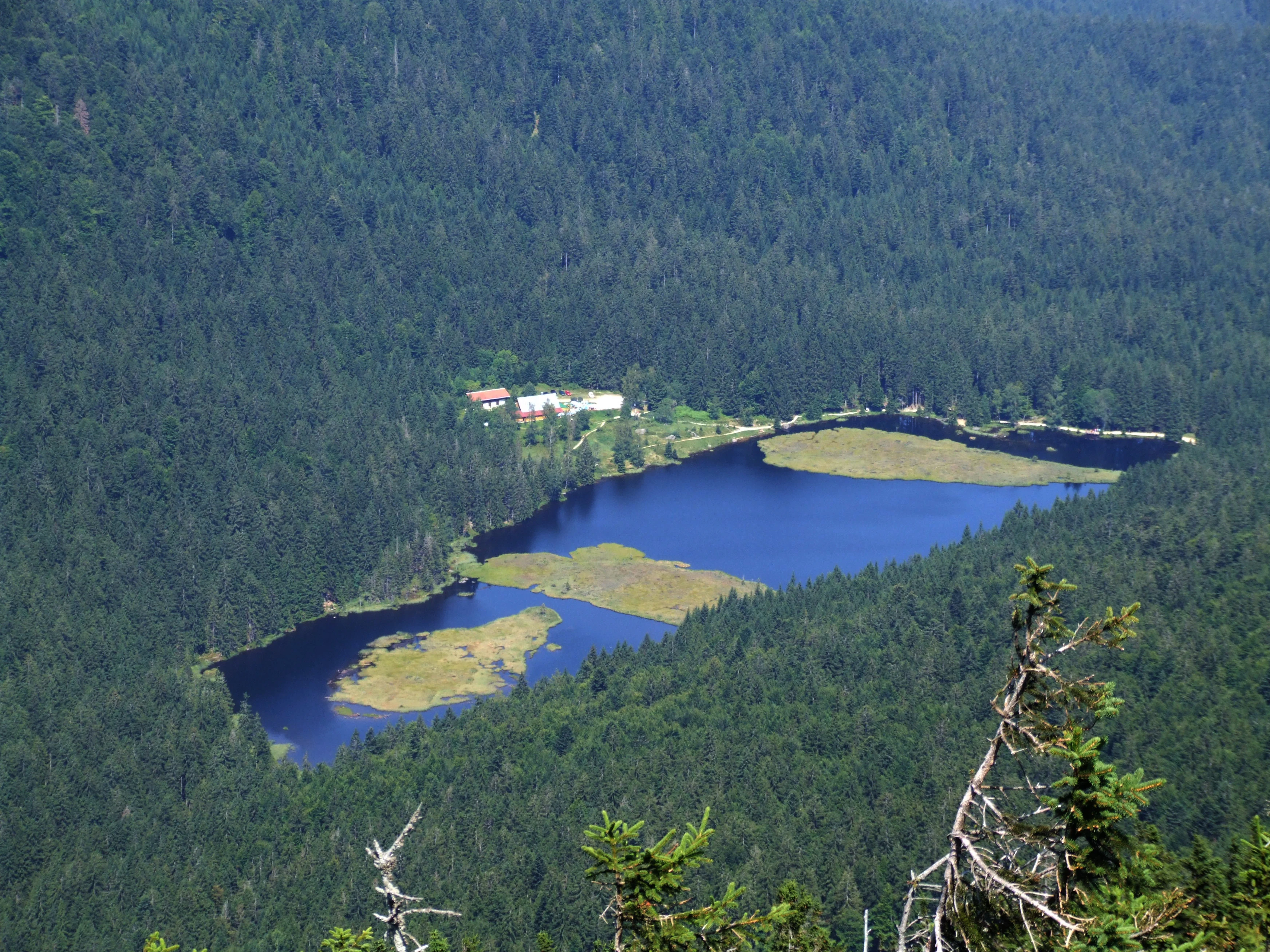
An elevated view looking down upon Kleiner Arbersee, a dark blue lake featuring several floating islands, surrounded by deep green coniferous forest.
A high-angle view of Kleiner Arbersee, nestled within the dense forest of Naturpark Oberer Bayerischer Wald.

Naturpark Oberer Bayerischer Wald history and protected-area timeline

The Naturpark Oberer Bayerischer Wald was formally established in 1989 and is managed by the registered association Naturpark Oberer Bayerischer Wald e. V., headquartered in Cham. Since its designation, it has functioned as a combined landscape protection zone, recreation area and conservation framework covering the entirety of the Cham district and the eastern portion of the Schwandorf district.

Although the nature park itself is a relatively recent designation, the landscape it protects carries a much deeper human history. Prehistoric activity in the area extends back at least to the last interglacial period, around 80,000 years ago, when a remarkably well-preserved hand axe of early Paleolithic style was discovered near Pösing in the Regen valley. The region has yielded finds from every major prehistoric era up to the Roman Imperial period, making it one of the archaeologically richest low mountain regions in Bavaria.

A defining prehistoric site within the park is the Late Neolithic settlement of the so-called Chamer Gruppe near Knöbling, an archaeological culture named after this very landscape. Prehistoric and early historic hillfort earthworks still mark the terrain at locations such as the Galgenberg near Cham, the Lamberg, Traitsching and Zenching. The medieval and early modern layers are equally prominent, with Cistercian monastery churches such as Walderbach and Reichenbach am Regen, pilgrimage churches including Weißenregen, Heilbrünnl and the famous double-altar church at Neukirchen beim Heiligen Blut, and a series of castles and ruins that once served the Nordgau's role in defending the eastern frontier of the Holy Roman Empire.

Naturpark Oberer Bayerischer Wald landscape and geographic character

The landscape of Naturpark Oberer Bayerischer Wald is dominated by the rolling ridges and forested peaks of the eastern Bavarian low mountain range. The highest summits include Kleiner Arber at 1,384 meters, Zwercheck at 1,333 meters and Großer Osser at 1,293 meters, followed by Enzian, Schwarzeck, Kaitersberg and Hoher Bogen. These summits give the park a clearly mountainous character in its southern and eastern sections, while the northwest transitions more gradually into the gentler Oberpfälzer Wald and the lower Cham-Further Senke in the center.

Glacial lakes, moors and small water bodies dot the terrain, with the Kleiner Arbersee being the most prominent lake landscape. Forest covers approximately 40 percent of the park, leaving a substantial amount of open landscape in the form of meadows, wetlands, rock outcrops and valley floors. The Regen river is the main hydrological spine, flow gn through the western portion of the park and beyond.

A defining geological element is the Pfahl, a roughly 150-kilometer-long quartzite ridge that runs through parts of the park in dramatic tower-like and pinnacled forms, considered a geological specialty of the region. The underlying rock composition is varied, with extensive granites and gneisses joined by mica schists around the Osser, examples of primeval limestone, and Cretaceous sediments visible in disused quarries such as the one at Obertrübenbach.

Naturpark Oberer Bayerischer Wald ecosystems, habitats, and plant life

The park's natural character is defined by an unusually broad mix of habitats for a single protected area. Forest remains the dominant land cover, but it is far from uniform: coniferous stands, mixed mountain forests with beech and spruce, drier pine forests on sandy soils, heathlands with low shrub vegetation, raised bogs around Arrach, wet meadow valleys and the floodplain forests and oxbow wetlands along the Regen river together provide an exceptionally varied habitat mosaic.

Meadow valleys within the park are notable for their orchid populations and other rare grassland flora, while the higher elevations support characteristic upland species such as the Bärwurz plant, a wild relative of the herbs used to produce the regionally famous Bärwurz liqueur. River valleys such as the Regentalaue provide large open wetland complexes that are significant both for plant communities and for breeding and migratory birds.

This habitat diversity is reinforced by overlapping layers of protection: roughly 76 percent of the park is under broader landscape protection, while around 2,084 hectares carry stricter nature reserve status. This includes reserves such as the Hölle, Kleiner Arbersee, Moorgebiet bei Arrach, Neubäuer Weiher, the Pfahl itself, the Pfahl-Ruine Schwärzenberg, the Regentalaue between Cham and Pösing, the Regentalhänge between Kirchenrohrbach and Zenzing, Schlossberg von Sattelpeilnstein, Schlosspark Falkenstein, the Weichselbrunner Weiher with adjacent dry pine forest near Bodenwöhr, and the forest-heath landscape east of Bodenwöhr and Bruck.

Naturpark Oberer Bayerischer Wald wildlife and species highlights

The wildlife profile of the park benefits from the close interconnection of forest, wetland and meadow habitats across relatively short distances. Raptor and other bird species of conservation interest find important refuge in the park, particularly in the Regentalaue wetland complex west of Cham, which together with the Rötelseeweiher ponds is highlighted as a productive birdwatching area within the broader protected landscape.

The mosaic of dry pine forest, heathland, raised bog, river floodplain and mixed mountain forest supports a wide range of typical central European low mountain species. While the regional species lists are extensive, the park's value for wildlife is best understood through habitat structure rather than individual animal records: forests retained across decades, unfragmented river corridors such as the Regen, and large tracts of semi-open cultural landscape together maintain conditions for breeding birds, mammals typical of Bavarian uplands, amphibians in the pond and bog systems, and insects associated with the orchid-rich meadows.

Wetland reserves around the Regen river and the Kleiner Arbersee area carry particular significance for amphibians, dragonflies and waterbirds, while the larger forest blocks provide continuous habitat for species sensitive to fragmentation. The combination of legally protected core zones embedded within a much broader landscape protection area is a deliberate design that allows ecological processes to extend beyond strict reserve boundaries.

Naturpark Oberer Bayerischer Wald conservation status and protection priorities

Conservation is a foundational purpose of the Naturpark Oberer Bayerischer Wald, expressed through layered protection rather than a single designation. About 76 percent of the park's area falls under landscape protection, which regulates land use across the entire Cham district and the eastern part of the Schwandorf district. Within this broader frame, around 2,084 hectares are designated as strict nature reserves, creating a network of core zones that anchor the park's biodiversity value.

Among these reserves, the Regentalaue between Cham and Pösing and the Regentalhänge between Kirchenrohrbach and Zenzing are central to conserving the floodplain ecosystems of the Regen river. Other reserves focus on specific habitat types: the Moorgebiet bei Arrach protects raised bog systems, the Weichselbrunner Weiher and Trockkiefernwald bei Bodenwöhr combines a pond complex with dry pine forest and heathland, the Naturschutzgebiet Pfahl protects the famous quartzite ridge along with associated flora, and the forest-heath reserve east of Bodenwöhr and Bruck conserves one of the region's rare lowland sand and heath landscapes.

The park's role in geological conservation is also notable: the disused quarry near Pingarten, exposing Pingartener Porphyr, has been recognized as one of the hundred most beautiful geotopes in Bavaria, while sites around the Osser and the Cretaceous transgression layers at Obertrübenbach are similarly highlighted. Mineral collecting tours at the former Fürstenzeche in Lam provide an additional link between geological heritage and public education.

Naturpark Oberer Bayerischer Wald cultural meaning and human context

The cultural dimension of the Naturpark Oberer Bayerischer Wald is unusually pronounced, reflecting thousands of years of continuous human presence in this low mountain landscape. Prehistoric settlement is one of the defining themes: the park includes the type region of the Late Neolithic Chamer Gruppe, with its characteristic pottery and settlement patterns, and contains numerous prehistoric and early historic hilltop enclosures and earthworks that mark earlier forms of territorial organization.

The medieval period left a deep imprint in the form of Romanesque sacred architecture. The Cistercian monastery church at Walderbach is regarded as one of the finest Romanesque Cistercian churches in Germany, with monumental Romanesque murals, while the monastery church at Reichenbach am Regen is a twin-towered, three-aisled Romanesque basilica featuring stucco and painted decoration. Pilgrimage churches such as Weißenregen above Bad Kötzting, with its distinctive carved fisherman's pulpit, and the elaborate complex at Neukirchen beim Heiligen Blut, where the Franciscans in 1658 attached their choir directly to the older parish church by breaking through its east wall and creating a rare liturgical double altar in Augsburg goldsmith work of around 1750, are among the park's most celebrated cultural landmarks.

Smaller chapels and pilgrimage sites such as Heilbrünnl near Roding, Lamberg, Schönferchen, the Margarethenkapelle near Einsiedel and the Tannerl near Falkenstein complement this sacred architecture. Castle ruins and fortifications in the park reflect the historical role of the Nordgau in defending the eastern frontier of the Holy Roman Empire. Regional traditional products, especially Bärwurz spirit distilled from the wild Bärwurz that grows on the higher slopes, link the cultural identity of the park directly to its natural plant heritage.

Top sights and standout views in Naturpark Oberer Bayerischer Wald

Among the park's most distinctive features is the Pfahl, a roughly 150-kilometer quartzite ridge whose tower-like rock formations make it a signature geological landmark of the Bavarian Forest. The Kleiner Arbersee and the surrounding mountain lakes add a contrasting element of glacial water scenery. The Regentalaue wetlands west of Cham, with the Rötelseeweiher ponds, form the park's strongest birdwatching and floodplain habitat, while the dry pine forests with heath understorey and the orchid-rich meadow valleys represent the park's most botanically distinctive open habitats.

Beyond its natural highlights, the park carries a dense layering of cultural sites, from the Cistercian Romanesque at Walderbach and Reichenbach am Regen to the pilgrimage churches at Weißenregen, Neukirchen beim Heiligen Blut and Heilbrünnl, and the prehistoric sites of the Chamer Gruppe and the early Paleolithic hand axe find at Pösing. Together, these features make the park a landscape where mountain scenery, wetland ecology, geological rarity and centuries of human settlement coexist within a single protected frame.

Best time to visit Naturpark Oberer Bayerischer Wald

The Naturpark Oberer Bayerischer Wald is accessible year-round, and each season emphasizes a different character of the landscape. Late spring and early summer are particularly rewarding for the orchid-rich meadow valleys and for the birdlife of the Regentalaue wetlands west of Cham, when migratory and breeding birds are most active. Summer brings comfortable conditions for hiking, lake swimming at small waters such as the Kleiner Arbersee, and canoeing or boating along the Regen river between Blaibach and Regensburg, a roughly 120-kilometer water trail.

Autumn highlights the mixed forest cover and the traditional Bärwurz harvest on the higher slopes, while also offering crisp conditions for hiking and cycling through the forested ridges and valleys of the Bavarian and Oberpfälzer Wald. Winter transforms the higher elevations around peaks like Kleiner Arber, Zwercheck and Großer Osser into a skiing and cross-country landscape, with established downhill pistes around the principal summits and an extensive network of cross-country trails through the snowy valleys. The low-lying Cham-Further Senke in the center of the park tends to remain milder and accessible when the higher peaks are under snow, making it a useful winter alternative for walking and gentle cycling.

Monthly climate preview

Long-term representative temperature and precipitation averages for Bavaria

Naturpark Oberer Bayerischer Wald Climate and Monthly Weather Patterns

Naturpark Oberer Bayerischer Wald records documented baseline temperature and precipitation shifts across twelve measured intervals at a core coordinate reference. Analyzing the complete monthly climate normals dataset reveals detailed thermal ranges and moisture patterns for this protected location.
Annual mean8 °C
-2 °C19 °C
Jan-2°
Feb-1°
Mar
Apr
May13°
Jun17°
Jul19°
Aug19°
Sep14°
Oct
Nov
Dec-1°
Warmest month
July

18.8 °C

Coolest month
January

-2.2 °C

Wettest month
June

3 mm/day

Driest month
April

1.4 mm/day

Park location guide

Geography guide, regional context, and park location map for Naturpark Oberer Bayerischer Wald

Naturpark Oberer Bayerischer Wald park geography, regions, and map view in Germany

Understand where Naturpark Oberer Bayerischer Wald sits in Germany through a broader geographic reading of the surrounding landscape, nearby location context, and its mapped position within the national park landscape.

How Naturpark Oberer Bayerischer Wald fits into Germany

Germany is a federal republic in Western and Central Europe with a population of over 83 million across sixteen constituent states. It is Europe's largest economy by nominal GDP and a major global exporter and importer. The capital is Berlin, and the country borders Denmark, Poland, Czech Republic, Austria, Switzerland, France, Luxembourg, Belgium, and the Netherlands.

Wider geography shaping Naturpark Oberer Bayerischer Wald in Germany

Germany is located in Western and Central Europe, spanning 357,022 km². It borders Denmark to the north, Poland and the Czech Republic to the east, Austria and Switzerland to the south, and France, Luxembourg, Belgium, and the Netherlands to the west. The country has coastlines on the Baltic Sea and North Sea to the north, with the Alps located in the southern region.

Map view of Naturpark Oberer Bayerischer Wald

Use this park location map to pinpoint Naturpark Oberer Bayerischer Wald in Germany, understand its exact geographic position, and read its mapped placement within the surrounding landscape more clearly.

Pigeon | © OpenStreetMap contributors

Location context for Naturpark Oberer Bayerischer Wald

Bavaria

Visual reference for forested ridges, river wetlands, and glacial lakes

Naturpark Oberer Bayerischer Wald Photos: Scenery and Landscapes

Visual documentation captures the varied terrain, upland forests, and protected habitats of Naturpark Oberer Bayerischer Wald. Photographic collections illustrate geological formations, river floodplains, and mountain scenery across the protected region.

An elevated view looking down upon Kleiner Arbersee, a dark blue lake featuring several floating islands, surrounded by deep green coniferous forest.

A wide, hazy panoramic view of forest-covered rolling hills and valleys in the Bavarian countryside.

Park atlas

Compare adjacent Bavarian mountain terrain, river valleys, and regional nature reserves.

Parks Near Naturpark Oberer Bayerischer Wald and Surrounding Protected Landscapes

Browsing other protected areas near Naturpark Oberer Bayerischer Wald reveals shared low mountain terrain, river floodplains, and forested ridges across eastern Bavaria. Examining adjacent conservation zones provides valuable geographical context for understanding regional habitats and neighboring natural landmarks.
A soft, pastel watercolor painting of a serene pond landscape with gentle green hills, grassy banks, and a light pink and yellow sky.
Nature reservePlzeňský kraj
About 25 km away#1 closest

Northeast

Postřekovské rybníky Nature Reserve: A Detailed Geographic Atlas of Bohemian Wetlands

Protected fishpond landscapes and wetland geography in Plzeňský kraj.

Postřekovské rybníky is a protected nature reserve situated between Postřekov and Klenčí pod Čerchovem. The landscape features over twenty traditionally managed fishponds embedded in a mosaic of damp meadows and stream floodplains. This compact area functions as a significant migratory site and breeding ground, representing a vital remnant of traditional Bohemian land management and specialized wetland ecology.

Area
0.965 km²
Established
1990
IUCN
IV
Relief
Lowland
Protected landscapeBavaria
About 33 km away#2 closest

Northwest

Naturpark Oberpfälzer Wald: Geographic Atlas and Protected Landscape Overview in Bavaria

Examining the terrain, forest ridges, and regional drainage patterns.

Naturpark Oberpfälzer Wald serves as a prominent protected landscape in Bavaria, Germany. This area encompasses a complex of Scots pine and Norway spruce forests, rugged rock outcrops, and the historic Charlottenhofer Weihergebiet. The region connects seamlessly to broader European mountain belts, offering a unique opportunity to study the intersection of traditional land use and natural conservation within the Oberpfalz administrative district.

Area
823 km²
Established
1994
Relief
Mountain
Climate
Temperate
Natural monumentPlzeňský kraj
About 33 km away#3 closest

North

Veský mlýn Natural Monument: Geographic Overview and Protected Landscape Mapping

A preserved wetland mosaic in the Bohemian Forest region

Veský mlýn is a protected natural monument in western Bohemia characterized by its transitional mire and wet meadow habitats. Situated within the Plzeňský kraj region, the site provides a distinct look at how former restricted border zones have maintained high ecological value. Its geography includes the headwaters of the Plešský potok and rare flora that thrive in the cool, moist conditions of the local crystalline foothills.

Area
0.321 km²
Established
2002
IUCN
IV
Relief
Upland
Protected landscapeBavaria
About 34 km away#4 closest

Northwest

Naturpark Nördlicher Oberpfälzer Wald: Protected Landscape and Regional Geography Map

Forested upland terrain and volcanic geology in Bavaria

Explore the structured geography of Naturpark Nördlicher Oberpfälzer Wald, a massive protected region in Bavaria. This detailed profile highlights the park's characteristic ridge and valley terrain, volcanic basalt landmarks, and its role as a vital ecological belt along the international border.

Area
1,380 km²
Water
Minor water
Watercolor painting showing mountains, forests, and valleys in a landscape.
National parkGermany
About 39 km away#5 closest

Southeast

Bavarian Forest National Park: Protected Landscape and Regional Geography Atlas

Explore mapped terrain and protected park boundaries in Germany.

Dive into the specifics of Bavarian Forest National Park, a key protected area noted for its distinct landscape and geographic importance. This MoriAtlas entry details the park's mapped boundaries and its setting within the surrounding regional geography, offering a clear atlas-style view of its natural terrain. Understand its identity as a national park and discover its place in Germany's protected lands.

Area
242.45 km²
Established
1970
IUCN
II
Visitors
1.3M annual
Watercolor illustration of a river flowing through a forested landscape with rolling hills in the background
National parkSouth Bohemian Region
About 41 km away#6 closest

Southeast

Šumava National Park: Czech Republic's Premier Forested National Park and Protected Landscape

Explore the unique glacial lakes, peat bogs, and regional geography.

Šumava National Park, situated in the South Bohemian Region of the Czech Republic, is the nation's largest protected area and a vital component of Central Europe's forest ecosystems. This entry details its expansive terrain, highlighting the significant peat bog complexes and ancient glacial lakes that define its unique landscape. Discover the park's geographic context, mapped boundaries, and its importance as a protected natural asset within the broader regional atlas.

Area
680.64 km²
Established
1991
IUCN
II
Visitors
2M annual
A horizontal watercolor painting depicting a soft, atmospheric landscape with a foreground of purple and pink wetland grasses, a midground of scattered green coniferous trees, and hazy, distant mountain silhouettes in the background.
Nature reservePlzeňský kraj
About 42 km away#7 closest

East

Prameniště Nature Reserve: Protected Wetland and Mountain Spring Systems in Plzeňský kraj

Mapping the hydrological headwaters of the Šumava Mountains

Prameniště Nature Reserve represents a critical cluster of protected mountain springs and peat bogs across the Pancířský hřbet ridge. By focusing on the source areas for the Křemelná and Řezná rivers, this reserve maintains essential hydrological integrity within the wider Plzeňský kraj landscape. Its mosaic of sub-alpine peatlands and montane spruce forests provides an important study of high-altitude wetland geography in the central European mountains.

Area
3.536 km²
Established
1994
IUCN
IV
Relief
Mountain
A horizontal watercolor illustration of a misty moorland with soft green hills, patches of forest, and marshy foreground vegetation, rendered in a light, atmospheric palette.
Nature reserveLandkreis Regen
About 44 km away#8 closest

Southeast

Rotfilz Nature Reserve: Geographic Profile of a Bavarian Forest Peatland

Protected moorland geography and raised bog pine woodland

Rotfilz is a significant nature reserve situated within the Landkreis Regen district of Lower Bavaria. Known for its mature bog pine woodland and ongoing peatland restoration, this protected area offers a look at the historical moorland mosaic of the Bavarian Forest. The terrain, defined by Pleistocene deposits and a clear hydrological boundary, provides a compact but essential site for studying Central European bog conservation and landform evolution.

Area
12.88 km²
Established
1973
IUCN
IV

Common questions about visiting, size, designation, and location context for Naturpark Oberer Bayerischer Wald

Naturpark Oberer Bayerischer Wald FAQs for park facts, access, geography, and protected area context

Find quick answers about Naturpark Oberer Bayerischer Wald, including protected-area facts, park geography, trail and visitor context, and how the park fits into its surrounding country and regional landscape.
MoriAtlas Explorer

Continue Your Protected Areas Search Across the Global Atlas

Deepen your exploration by continuing the structured search for national parks and protected areas worldwide. Utilize the comprehensive filtering capabilities to compare different conservation landscapes and refine your understanding of global park geography. Discover more about the distribution and characteristics of protected natural areas.

Global natural geography