Mori Atlas logo
Protected landscapeNaturpark Randers Fjord

Explore the unique geography of Denmark's eastern Jutland coastal meadows and tidal wetlands

Naturpark Randers Fjord: A Protected Landscape of Estuaries and Coastal Tidal Habitats

Naturpark Randers Fjord stands as a significant protected area in Denmark, defined by the convergence of the Gudenå river delta and the complex estuarine environment of the Randers Fjord. The terrain encompasses a rare mosaic of eastern tidal flats, extensive reed beds, and coastal meadows that transition into inland heath and forest patches. This geographic data provides a structural look at the diverse habitat patterns shaping this protected landscape within the Randers Kommune region.

fjord estuaryriver deltatidal flatsreed bedscoastal meadowsheathland

Naturpark Randers Fjord

Protected landscape

Park overview

Structured park overview, official facts, and landscape profile for Naturpark Randers Fjord

Naturpark Randers Fjord park facts, protected area profile, and essential visitor context

Review the core facts for Naturpark Randers Fjord, including designation, size, terrain, visitor scale, habitats, and operating context in one park-focused overview.

About Naturpark Randers Fjord

Naturpark Randers Fjord is a Danish nature park that surrounds the Randers Fjord estuary in eastern Jutland, where the Gudenå, Denmark's longest river, meets the sea. Designated in early 2018 and opened later that spring, the park brings together a remarkable variety of Danish natural habitats in close proximity, making it one of the most ecologically varied protected landscapes in the country.

The coastal and estuarine zones form the heart of the park. The freshwater delta of the Gudenå is one of the most distinctive river-mouth landscapes in Denmark, while the tidal flats at Udbyhøj represent the country's only east-facing wadden-type habitat. Around these core wetland areas lie extensive reed beds, with large stands of common reed and sweet-grass that are characteristic of the fjord shores. This reed forest along the Randers Fjord is among the largest of its kind in Denmark.

Inland from the fjord, the park includes stretches of coastal meadow, heathland, dry grassland, bogs, and several notable forest areas, often arranged in mosaics where multiple habitat types occur close together. This habitat variety supports a particularly wide range of species and gives the park a layered landscape identity: estuarine waters, tidal mudflats, brackish meadows, reed belts, heath, oak or mixed forest, and freshwater wetland all sit within the broader park boundary. The combination of river delta and tidal flat within a single protected area distinguishes Naturpark Randers Fjord from most other Danish parks and protected landscapes.

Quick facts and research context for Naturpark Randers Fjord

Naturpark Randers Fjord is located along the Randers Fjord estuary in eastern Jutland, Denmark, covering parts of Randers Municipality and Norddjurs Municipality.

It covers 29,250 hectares and is the second-largest of Denmark's designated nature parks. The park was officially designated on 1 February 2018 by the Danish Outdoor Council (Friluftsrådet) and opened to the public on 27 May 2018, after serving as a pilot nature park since 2014.

Protection and recognition

Examine the documented protection scope and international recognition framework.

Naturpark Randers Fjord Protection Status and Conservation Context

Naturpark Randers Fjord encompasses a mixed protection scope with documented administrative designations and management frameworks. Review the structured conservation context and international recognition details compiled for this protected area.

Protection details

Protection scope
Mixed
Park context

Deeper park guide and search-rich context for Naturpark Randers Fjord

Naturpark Randers Fjord history, landscape, wildlife, and travel context

Explore Naturpark Randers Fjord through its history, landscape character, ecosystems, wildlife, conservation priorities, cultural context, and seasonal travel timing in a structured park guide built for atlas discovery and search intent.

Why Naturpark Randers Fjord stands out

Naturpark Randers Fjord is best known for containing two nationally unique natural features: the Gudenå river delta where it empties into the Randers Fjord, and Denmark's sole east-facing tidal flat (vadehav) at Udbyhøj. Together, these coastal and estuarine ecosystems define the park's identity and account for its exceptional habitat diversity. Large reed beds along the fjord, coastal meadows, and a mosaic of heath, grassland, wetland, and forest habitats reinforce the park's reputation as a compact but ecologically rich landscape in eastern Jutland.
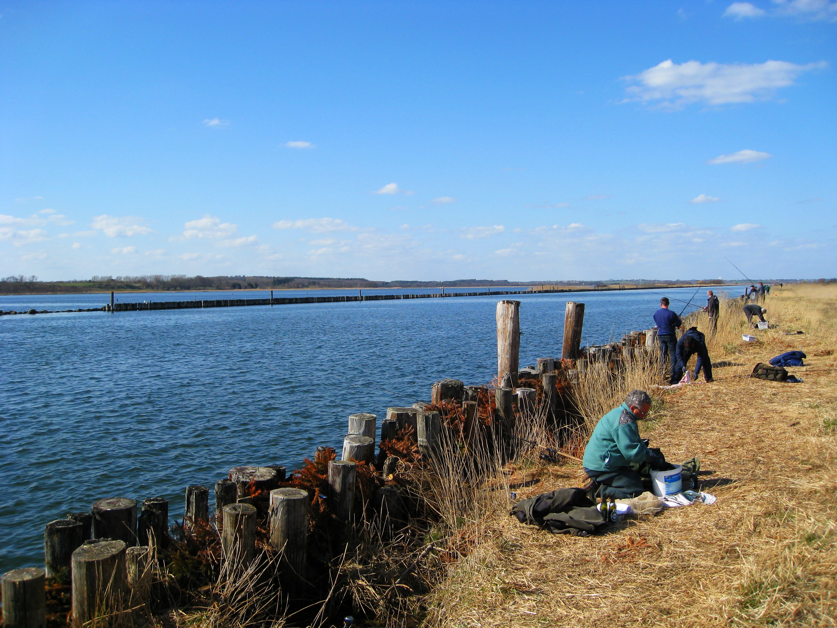
Several people sitting and standing along a grassy bank by a wide river, fishing with rods, with a wooden piling fence separating the bank from the water.
Anglers fishing along the banks of Randers Fjord near Voer.

Naturpark Randers Fjord history and protected-area timeline

The area that now makes up Naturpark Randers Fjord began its formal journey toward protected-area status in 2014, when it was designated a pilot nature park. This pilot phase allowed local stakeholders, municipalities, and conservation organizations to develop plans for the area's long-term management, visitor framework, and ecological priorities.

On 1 February 2018, Friluftsrådet, the Danish Outdoor Council, formally recognized the area as a full nature park under the Danish nature-park framework. The park was officially opened to the public on 27 May 2018, marking its transition from a planning initiative into an operational national-park-style landscape entity. The park's geography spans both Randers Municipality and Norddjurs Municipality, reflecting the cross-jurisdictional character of the fjord landscape.

Naturpark Randers Fjord landscape and geographic character

The landscape of Naturpark Randers Fjord is shaped around the north-south oriented Randers Fjord, an estuary that transitions from freshwater conditions near its head, where the Gudenå enters, to more brackish conditions toward the Kattegat at its mouth. Near Udbyhøj, the fjord shoreline opens into a tidal flat area that is unique in eastern Denmark, where tides shape mudflats and shallow water zones uncommon elsewhere on the country's eastern coastline.

Behind the immediate shoreline, low-lying coastal meadows line much of the fjord, interrupted by extensive reed beds dominated by common reed and sea club-rush. Inland, the terrain rises gently into a mosaic of heaths, dry grasslands, bogs, and forest patches. This varied relief creates a layered scenery where water, wetland, open heath, and woodland can all be visible from elevated vantage points, providing a strong sense of habitat transition across relatively short distances.

Naturpark Randers Fjord ecosystems, habitats, and plant life

The park's ecological identity is defined by the proximity and interaction of freshwater, brackish, and tidal habitats. The Gudenå delta brings silt, nutrients, and freshwater plant communities into the fjord, while the tidal influence near Udbyhøj introduces marine and brackish species and processes. This meeting of river and sea produces diverse shoreline vegetation, including the extensive reed belts that are a signature feature of the park.

Coastal meadows along the fjord support salt-tolerant plant communities and provide nesting and feeding habitat for waterbirds, while inland heath and bog patches preserve open-landscape species associated with nutrient-poor conditions. Forests within the park add a wooded habitat layer, and the mosaic structure of heath, dry grassland, bog, and forest increases overall biodiversity by allowing distinct plant communities to coexist across short distances.

Naturpark Randers Fjord wildlife and species highlights

The combination of river-delta, tidal flat, reed beds, meadows, and inland habitats gives the park a notably rich fauna. Mammals such as otters are associated with the wetland and shoreline zones, while seals are present in the fjord waters. The park is also home to the natterjack toad, a species associated with open, sandy or short-vegetated habitats.

Birdlife is one of the most prominent aspects of the park's wildlife profile. Species such as cormorants and grey herons are typical of the reed beds, shallow fjord waters, and coastal meadows, while ospreys are notable seasonal visitors drawn by the rich fishing opportunities around the delta and fjord. The tidal flats and brackish shallows also support a wide variety of waterfowl and wading birds. In addition to birds and mammals, the fjord's varied salinity and habitat structure sustain a broad range of fish species, contributing to the park's overall biodiversity.

Naturpark Randers Fjord conservation status and protection priorities

Naturpark Randers Fjord holds substantial conservation value because it protects two nationally distinctive habitat types: the Gudenå freshwater delta and Denmark's only east-facing tidal flat. Each represents a rare or unique ecological configuration within Denmark, and their inclusion in a single nature park increases the habitat diversity under coordinated protection and management.

The large reed beds, coastal meadows, and inland heath-bog-forest mosaics are themselves conservation-relevant habitat complexes, providing breeding, feeding, and refuge areas for a wide range of species. By connecting estuarine, freshwater, and terrestrial ecosystems across municipal boundaries, the park contributes to landscape-scale conservation efforts in eastern Jutland and supports species that depend on multiple habitat types across the year.

Top sights and standout views in Naturpark Randers Fjord

The defining highlights of Naturpark Randers Fjord are its nationally rare Gudenå river delta and east-facing tidal flats at Udbyhøj, both of which give the park an unusual ecological profile within Denmark. The extensive reed belts that line the fjord are among the largest in the country and visually dominate many shoreline stretches.

A close mosaic of habitats, including coastal meadow, heath, bog, dry grassland, and forest, allows visitors to encounter several of Denmark's characteristic natural environments within a compact area. The combination of large-scale wetland and tidal scenery with inland traditional landscapes gives the park both ecological prominence and a strong sense of regional identity in eastern Jutland.

Monthly climate preview

Long-term representative measurements detailing annual temperature ranges and monthly precipitation cycles

Naturpark Randers Fjord Climate Normals, Monthly Temperature and Precipitation Patterns

Naturpark Randers Fjord exhibits measured monthly temperature variation alongside consistent precipitation patterns recorded across a representative coordinate. Accessing the complete twelve-month climate profile reveals comprehensive long-term data for deeper regional analysis.
Annual mean8 °C
1 °C17 °C
Jan
Feb
Mar
Apr
May11°
Jun14°
Jul17°
Aug17°
Sep13°
Oct
Nov
Dec
Warmest month
July

16.8 °C

Coolest month
January

0.7 °C

Wettest month
October

2.7 mm/day

Driest month
April

1.5 mm/day

Park location guide

Geography guide, regional context, and park location map for Naturpark Randers Fjord

Naturpark Randers Fjord park geography, regions, and map view in Denmark

Understand where Naturpark Randers Fjord sits in Denmark through a broader geographic reading of the surrounding landscape, nearby location context, and its mapped position within the national park landscape.

How Naturpark Randers Fjord fits into Denmark

Denmark is a constitutional monarchy and Nordic country in Northern Europe. It is the southernmost of the Scandinavian countries, bordering Germany to the south, Norway to the north, and Sweden to the southwest. The country consists of the Jutland peninsula and an archipelago of islands, with Copenhagen as its capital and largest city. Denmark has a population of over 6 million and is characterized by flat, arable land, sandy coasts, and a temperate climate.

Wider geography shaping Naturpark Randers Fjord in Denmark

Denmark occupies the Jutland peninsula and roughly 406 islands in Northern Europe. It is situated between the North Sea to the west and the Baltic Sea to the east. The country borders Germany to the south and is connected to Sweden via the Øresund Bridge. Denmark is predominantly flat terrain with low elevation, the highest point being Møllehøj at 170.86 meters.

Map view of Naturpark Randers Fjord

Use this park location map to pinpoint Naturpark Randers Fjord in Denmark, understand its exact geographic position, and read its mapped placement within the surrounding landscape more clearly.

Pigeon | © OpenStreetMap contributors

Location context for Naturpark Randers Fjord

Norddjurs KommuneRanders Kommune

Explore coastal meadows, tidal flats, and estuarine habitats through detailed park photography.

Naturpark Randers Fjord Landscape and Scenery: Visual Protected Area Reference

Visual records reveal the diverse terrain and estuarine ecosystems spanning the Gudenå river delta and tidal flats of Naturpark Randers Fjord. Photographic documentation captures the distinct wetland habitats and protected coastal scenery that characterize eastern Jutland.

Several people sitting and standing along a grassy bank by a wide river, fishing with rods, with a wooden piling fence separating the bank from the water.

Park atlas

Compare regional geography, estuarine ecosystems, and nearby protected habitats

Parks Near Naturpark Randers Fjord and Surrounding Protected Landscapes

Browse other protected areas and nearby national parks that share regional geography with Naturpark Randers Fjord. Continuing into surrounding coastal landscapes and river deltas provides deeper context for eastern Jutland habitats.
A stylized digital illustration of a valley featuring a cascading waterfall between two mountains, with a winding river in the foreground and pine trees.
Protected areaDenmark
About 4.8 km away#1 closest

Southwest

Randers Fjord Protected Area: Mapping the Reed-Dominated Estuaries of Eastern Denmark

Coastal river mouth geography and tidal wetland terrain

Randers Fjord represents a significant protected area in eastern Jutland, Denmark, characterized by its winding water corridor and tall stands of common reed. This geographic survey details the transition from the Gudenå river channel to the Kattegat, highlighting the marsh-like atmosphere and conservation-focused wetlands that define the regional coastline.

Established
2018
Relief
Lowland
Climate
Temperate
Access
Easy access
A soft watercolor painting showing a panoramic view of trees, water, and marshy land, rendered in a muted color palette.
Nature reserveRegion Midtjylland
About 16 km away#2 closest

Southeast

Eldrup Skov og søer og moser i Løvenholm Skov: Geographic Map and Protected Landscape

An ecologically layered nature reserve in Region Midtjylland

This protected area unit unites five distinct parcels, including Gjesing Mose and Løvenholm Langsø, to preserve a rare slice of Danish forest and peatland. Use this mapping resource to understand the transition from dense broadleaf woodland to open raised bog habitats. The area represents a primary example of habitat restoration and conservation, showcasing how small, fragmented ecosystems retain their ecological integrity within a larger forest complex.

Area
1.55 km²
Established
2011
Relief
Lowland
Climate
Temperate
Watercolor illustration showing rolling hills, a lake, pink flowering trees, and distant mountains
National parkDenmark
About 27 km away#3 closest

Southeast

Mols Bjerge National Park: Glacial Geography and Protected Terrain in Central Jutland

Mapping the coastal cliffs and rolling heathland of Denmark

Mols Bjerge National Park protects a sweeping mosaic of glacial hills, woodlands, and coastal zones on the Djursland peninsula. With a landscape shaped by ancient ice sheets, the park offers a detailed view into Denmark's geological history, preserved ancient barrows, and rich botanical diversity along the Kattegat sea.

Area
180 km²
Established
2009
IUCN
II
Relief
Upland
Watercolor painting of a panoramic landscape featuring green rolling hills, light foliage, and patches of pink wildflowers in the foreground.
National parkCentral Jutland
About 36 km away#4 closest

Southeast

Nationalpark Mols Bjerge: A Geographic Overview of Central Jutland's Glacial Landscape

Mapped terrain, dead-ice hills, and prehistoric monuments

Nationalpark Mols Bjerge offers a deep look into the glacial heritage of Central Jutland. The area features steep, sun-exposed slopes, heathland, and coastal fringes that provide a unique perspective on the Danish landscape. By examining the park's mapped boundaries, one can identify the convergence of geological landforms and ancient cultural history preserved within this protected environment.

Relief
Mountain
Access
Easy access
Water
Major water bodies
Nature reserveRegion Midtjylland
About 37 km away#5 closest

South

Tved Kær Nature Reserve: Protected Coastal Habitat Geography in Region Midtjylland

Exploring lime-rich fens and coastal cliff terrain.

Tved Kær represents a compact but ecologically dense protected area in Denmark, known for its rare calcareous fen and seepage vegetation. Situated near the village of Tved, this nature reserve integrates coastal cliffs and raised seabed to form a distinct habitat mosaic within the Mols peninsula, serving as a vital site for rare orchid species and lime-rich soil preservation.

Area
0.06 km²
Established
1981
Relief
Lowland
Climate
Temperate
Watercolor painting of a hilly, green, and light-filled landscape featuring low mounds and soft vegetation typical of moorland.
Protected areaDenmark
About 37 km away#6 closest

West

Ø Bakker Protected Area: A Map of the Heath-Covered Ridge in Central Jutland, Denmark

Glacial ridge geography in the Nørreå valley

Ø Bakker stands as a striking geological landmark where a heather-clad hill ridge rises sharply from the lowland meadows of Denmark. This protected area offers clear insights into the undulating terrain and dry heath habitats preserved between the meanders of the Nørreå river, providing a valuable study in regional glacial geomorphology and conservation mapping.

Area
2.85 km²
Established
1975
Relief
Upland
Climate
Temperate
Nature reserveRegion Midtjylland
About 39 km away#7 closest

Southeast

Stubbe Sø Nature Reserve: A Geographic Exploration of Djursland Protected Landscapes

Mapping the wetlands, forest fringes, and mire systems of eastern Jutland.

Stubbe Sø is a central protected feature within the landscape of eastern Jutland, comprising a large shallow lake surrounded by alder-birch shorelines and coniferous plantations. This nature reserve offers deep insight into the glaciated terrain and wetland mosaic of the Djursland peninsula, providing an essential geographic reference for understanding local conservation habitats and regional waterbird migration corridors.

Area
7.78 km²
Established
1963
Relief
Lowland
Climate
Temperate
A wide watercolor illustration of a lake surrounded by green trees and rolling hills, with a small tree and pink flowers in the foreground.
Nature reserveAarhus Kommune
About 41 km away#8 closest

South

Brabrand Sø Nature Reserve: Mapped Geography of an Aarhus Glacial Tunnel Valley

Protected freshwater wetlands and urban green corridors in Denmark

Brabrand Sø represents a rare, shallow freshwater lake and wetland complex located at the edge of the Aarhus urban fabric. This nature reserve, formed within a post-glacial tunnel valley, remains a cornerstone of the regional landscape through its integration of bird habitats, drinking-water protection, and open meadow terrain. The area offers a profound look at how peri-urban green infrastructure sustains both ecological health and geological character in the Aarhus Kommune region.

Area
1.54 km²
Established
1959
Relief
Lowland
Climate
Temperate

Common questions about visiting, size, designation, and location context for Naturpark Randers Fjord

Naturpark Randers Fjord FAQs for park facts, access, geography, and protected area context

Find quick answers about Naturpark Randers Fjord, including protected-area facts, park geography, trail and visitor context, and how the park fits into its surrounding country and regional landscape.
MoriAtlas Explorer

Continue Your Protected Areas Search Across the Global Atlas

Deepen your exploration by continuing the structured search for national parks and protected areas worldwide. Utilize the comprehensive filtering capabilities to compare different conservation landscapes and refine your understanding of global park geography. Discover more about the distribution and characteristics of protected natural areas.

Global natural geography