

Mori Atlas logo
Nature reserveNaturschutzgebiet Oberes Hoppecketal

Understanding the fluvial geography and floodplain connectivity of this eastern Sauerland reserve

Naturschutzgebiet Oberes Hoppecketal: Mapped Boundaries of a Protected River Valley Landscape

Naturschutzgebiet Oberes Hoppecketal preserves a near-natural stretch of the Hoppecke river within the eastern Sauerland of North Rhine-Westphalia. This nature reserve provides essential habitat connectivity by protecting the river corridor, its alluvial sediments, and associated wet grassland pockets. As an integral component of the broader Gewässersystem Diemel und Hoppecke Natura 2000 network, the site serves as a vital anchor for regional river-conservation landscapes and aquatic biodiversity.

river valleyfloodplainwet grasslandfreshwater habitatNatura 2000FFH site
A stylized vector illustration of a river flowing through a forested valley with tall, light-colored rock cliffs in the background and fallen logs on the riverbank in the foreground.

Naturschutzgebiet Oberes Hoppecketal

Nature reserve

Park overview

Structured park overview, official facts, and landscape profile for Naturschutzgebiet Oberes Hoppecketal

Naturschutzgebiet Oberes Hoppecketal park facts, protected area profile, and essential visitor context

Review the core facts for Naturschutzgebiet Oberes Hoppecketal, including designation, size, terrain, visitor scale, habitats, and operating context in one park-focused overview.

About Naturschutzgebiet Oberes Hoppecketal

Naturschutzgebiet Oberes Hoppecketal is a compact but ecologically meaningful protected area in the Hochsauerlandkreis of North Rhine-Westphalia. Located just south of Brilon-Wald within the city of Brilon, the reserve follows the upper course of the Hoppecke river and encompasses the floodplain that has developed along this stretch. Although the protected area is small, roughly 21.4 hectares, it reflects the typical river and valley pattern of the eastern Sauerland, where relatively narrow streams have carved gentle valleys bordered by species-rich meadows, wet habitats, and adjacent woodland fringes.

The reserve was formally designated as a Naturschutzgebiet in 2001 under the Hoppecketal landscape plan prepared by the Hochsauerlandkreis. Its creation reflects a regional effort to maintain near-natural freshwater habitats and floodplain ecosystems in an area where land use has historically included forestry, pasture, and small-scale agriculture. The Hoppecke and its tributaries form part of the broader Diemel river system, and the entire network receives European-level conservation attention through the Habitats Directive.

The reserve falls within the FFH area Gewässersystem Diemel und Hoppecke (DE 4617-302), tying this small local site into a much larger Natura 2000 conservation framework. This integration highlights that even modest protected stretches along the Hoppecke are valued for their role in maintaining habitat connectivity, supporting characteristic valley biodiversity, and securing long-term ecological function across the region's river systems.

Quick facts and research context for Naturschutzgebiet Oberes Hoppecketal

Naturschutzgebiet Oberes Hoppecketal lies in the Brilon city area, south of the Brilon-Wald district, in the Hochsauerlandkreis of North Rhine-Westphalia. The reserve was designated in 2001 through the Hoppecketal landscape plan and covers approximately 21.4 hectares.

The protected area centers on the upper course of the Hoppecke river and its floodplain. It is officially listed under the designation HSK-184 in the North Rhine-Westphalia nature conservation information system and is integrated into the FFH area Gewässersystem Diemel und Hoppecke (DE 4617-302), making it part of the wider Natura 2000 ecological network. Protection aims include preserving near-natural river reaches, their floodplain connectivity, fragments of wet grassland, and habitats for threatened plant and animal species documented in Red Lists.

Protection and recognition

Documented terrestrial protection scope and official designation details

Naturschutzgebiet Oberes Hoppecketal Protection Status and Recognition Data

Terrestrial protection status and designation history define the conservation framework for Naturschutzgebiet Oberes Hoppecketal. Documented management scope and official administrative records provide structured insight into regional landscape administration.

Protection details

Protection scope
Terrestrial
Transboundary protection
No
Park context

Deeper park guide and search-rich context for Naturschutzgebiet Oberes Hoppecketal

Naturschutzgebiet Oberes Hoppecketal history, landscape, wildlife, and travel context

Explore Naturschutzgebiet Oberes Hoppecketal through its history, landscape character, ecosystems, wildlife, conservation priorities, cultural context, and seasonal travel timing in a structured park guide built for atlas discovery and search intent.

Why Naturschutzgebiet Oberes Hoppecketal stands out

The reserve is best known for protecting a near-natural stretch of the Hoppecke river and its floodplain in the upper reaches of the Hoppecke valley. It preserves the characteristic river-aue mosaic that defines this part of the eastern Sauerland, combining flowing water, soft floodplain soils, and small pockets of moisture-loving grassland. Its integration into the Natura 2000 network as part of the larger Gewässersystem Diemel und Hoppecke FFH site also gives it broader significance as a building block in one of the region's key river-conservation landscapes, where protecting connectivity between river sections and their floodplains is a central ecological objective.
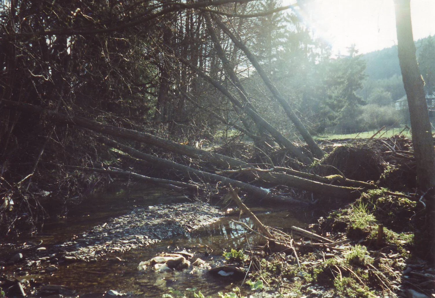
A shallow, winding river flows through a dense forest with several fallen trees spanning the banks in the Naturschutzgebiet Oberes Hoppecketal.
The upper reaches of the Hoppecke river flowing through the Naturschutzgebiet Oberes Hoppecketal.

Naturschutzgebiet Oberes Hoppecketal history and protected-area timeline

The Naturschutzgebiet Oberes Hoppecketal was formally designated as a nature reserve in 2001. Its establishment came through the Landschaftsplan Hoppecketal, a landscape planning document prepared by the Untere Landschaftsbehörde of the Hochsauerlandkreis.

The 2001 designation built on the broader recognition that the Hoppecke river system, including its upper reaches, was ecologically valuable and in need of formal protection. By incorporating the reserve into the regional landscape plan, local authorities anchored the site within the county's environmental planning framework and provided a legal basis for its ongoing protection.

Naturschutzgebiet Oberes Hoppecketal landscape and geographic character

The landscape of the reserve is defined by the upper reaches of the Hoppecke river and its floodplain, creating a long, narrow valley habitat. The valley floor accommodates the river channel itself, soft alluvial sediments, and a floodplain zone that varies in width along the protected stretch. On slightly higher ground, the valley transitions into the typical mixed forest and meadow mosaic of the eastern Sauerland.

Small-scale relief, varying soil moisture, and the interplay between flowing water, wet soils, and drier valley edges create an environment in which habitats grade into one another across short distances. Even though the protected area is small, this transition between aquatic, floodplain, and terrestrial habitats gives the valley a noticeably varied local character.

Naturschutzgebiet Oberes Hoppecketal ecosystems, habitats, and plant life

Ecologically, the reserve preserves a representative example of a near-natural upland river and floodplain system. The hopping Hoppecke corridor and its accompanying aue provide the structural backbone of the site's ecological value, supporting moisture-loving vegetation along the banks and floodplain meadows that depend on the river's hydrology.

Adjacent areas include small patches of wet grassland, particularly in the southern part of the reserve, along with transition zones into woodland habitats. Together, these elements create a habitat mosaic typical of river valleys in the Sauerland, sustaining both aquatic and terrestrial species that benefit from the close coupling of water, floodplain soils, and valley vegetation. The integration of the site into the Natura 2000 network reflects its role in maintaining this ecological pattern at a regional scale.

Naturschutzgebiet Oberes Hoppecketal wildlife and species highlights

The reserve's wildlife value is closely tied to its river and floodplain habitats, though the available source material emphasizes plant communities rather than specific fauna records. The protected river sections and their aue zones provide habitat for aquatic and semi-aquatic species that depend on clean, near-natural watercourses.

The presence of multiple Red List plant and animal species documented in the area indicates that the reserve supports a broader community of organisms whose survival depends on these valley habitats. Wet grassland remnants in the southern part of the site and undisturbed stream reaches offer particular value for species that require stable, moisture-rich environments.

Naturschutzgebiet Oberes Hoppecketal conservation status and protection priorities

Conservation significance in Naturschutzgebiet Oberes Hoppecketal is centered on the protection of near-natural river sections and their floodplain habitats. The landscape plan explicitly cites the rarity, special character, and beauty of the area as reasons for its designation, alongside the need to keep protected sites ecologically functional.

The reserve also serves as a component of the larger FFH area Gewässersystem Diemel und Hoppecke. This positions the site within the Natura 2000 ecological network, where the principal conservation objective is to maintain and reconnect river and floodplain habitats across the Diemel and Hoppecke systems. By safeguarding connectivity and supporting populations of Red List species, the reserve contributes to the broader goal of preserving viable habitats for valley- and river-dependent biodiversity in the eastern Sauerland.

Top sights and standout views in Naturschutzgebiet Oberes Hoppecketal

The reserve's strongest feature is its near-natural upper stretch of the Hoppecke river and the accompanying floodplain, which together define the ecological identity of the site. Its small size is offset by its integration into the larger Gewässersystem Diemel und Hoppecke Natura 2000 area, giving it regional relevance beyond its local footprint.

Other notable qualities include the presence of wet grassland remnants, particularly in the southern part of the reserve, and the documentation of numerous plant species associated with traditional valley landscapes. These elements reflect a long history of low-intensity land use that has helped maintain habitat diversity along the Hoppecke valley.

Best time to visit Naturschutzgebiet Oberes Hoppecketal

Spring and early summer are typically the most rewarding periods for visiting Sauerland river valleys like this one. Flowering valley meadows, fresh green floodplain vegetation, and active growth along the riverbanks make this season especially suitable for observing the botanical character of the area.

Late spring and early summer also tend to provide comfortable conditions for walking in the valley. Visiting during drier weather allows better access to the floodplain meadows and clearer views of the Hoppecke and its banks, although the natural appeal of the site is not strongly seasonal for general landscape exploration.


Monthly climate preview

Long term temperature and precipitation measurements for North Rhine Westphalia terrain

Naturschutzgebiet Oberes Hoppecketal Climate Normals and Annual Weather Rhythm

Representative coordinates record measured monthly temperature swings from sub zero lows to warm highs alongside steady precipitation normals. Exploring the complete twelve month profile reveals detailed variations across the local conservation area.
Annual mean9 °C
0 °C18 °C
Jan
Feb
Mar
Apr
May12°
Jun15°
Jul18°
Aug18°
Sep14°
Oct
Nov
Dec
Warmest month
July

18 °C

Coolest month
January

-0.2 °C

Wettest month
July

2.6 mm/day

Driest month
April

1.7 mm/day

Park location guide

Geography guide, regional context, and park location map for Naturschutzgebiet Oberes Hoppecketal

Naturschutzgebiet Oberes Hoppecketal park geography, regions, and map view in Germany

Understand where Naturschutzgebiet Oberes Hoppecketal sits in Germany through a broader geographic reading of the surrounding landscape, nearby location context, and its mapped position within the national park landscape.

How Naturschutzgebiet Oberes Hoppecketal fits into Germany

Germany is a federal republic in Western and Central Europe with a population of over 83 million across sixteen constituent states. It is Europe's largest economy by nominal GDP and a major global exporter and importer. The capital is Berlin, and the country borders Denmark, Poland, Czech Republic, Austria, Switzerland, France, Luxembourg, Belgium, and the Netherlands.

Wider geography shaping Naturschutzgebiet Oberes Hoppecketal in Germany

Germany is located in Western and Central Europe, spanning 357,022 km². It borders Denmark to the north, Poland and the Czech Republic to the east, Austria and Switzerland to the south, and France, Luxembourg, Belgium, and the Netherlands to the west. The country has coastlines on the Baltic Sea and North Sea to the north, with the Alps located in the southern region.

Map view of Naturschutzgebiet Oberes Hoppecketal

Use this park location map to pinpoint Naturschutzgebiet Oberes Hoppecketal in Germany, understand its exact geographic position, and read its mapped placement within the surrounding landscape more clearly.

Pigeon | © OpenStreetMap contributors

Location context for Naturschutzgebiet Oberes Hoppecketal

North Rhine-Westphalia

Visual exploration of river valley habitats and protected floodplain terrain

Naturschutzgebiet Oberes Hoppecketal Photos and Landscape Scenery

Visual documentation captures the near-natural river channel, alluvial sediments, and wet grassland pockets shaping the upper Hoppecketal valley. Examining these protected habitats reveals the diverse ecological character and valley terrain defining this Sauerland conservation area.

A shallow, winding river flows through a dense forest with several fallen trees spanning the banks in the Naturschutzgebiet Oberes Hoppecketal.

A small, flowing river with rocky banks surrounded by dense forest trees in a natural reserve.

Park atlas

Compare adjacent river valleys and regional conservation landscapes in the Sauerland

Parks Near Naturschutzgebiet Oberes Hoppecketal And Surrounding Protected Areas

Browse other parks and protected areas near Naturschutzgebiet Oberes Hoppecketal to examine connected river corridors and valley habitats across the surrounding region. Comparing adjacent natural reserves reveals the broader ecological mosaic and protected landscape patterns defining eastern Sauerland.
Nature reserveNorth Rhine-Westphalia
About 5.2 km away#1 closest

North

Naturschutzgebiet Poppenberg: A Detailed Geographic Overview of this Nature Reserve

Exploring Limestone Cliff Habitats and Regional Forest Ecosystems

Naturschutzgebiet Poppenberg represents an essential ecological link within the Brilon limestone hill network. This nature reserve offers a concentrated study in geology and ecology, showcasing exposed rock formations, historical mining traces, and a diverse range of woodland habitats compressed into a compact, protected area within North Rhine-Westphalia.

Area
0.007 km²
Established
2008
Relief
Upland
Climate
Temperate
A watercolor-style digital illustration of a gentle, rolling green landscape with a winding path and distant hills on a white background.
Nature reserveWaldeck-Frankenberg
About 7 km away#2 closest

South

Naturschutzgebiet Grebensteine bei Willingen: Protected Forest and Rock Outcrop Atlas

Ecological mapping of the Itter valley gorge forest in Waldeck-Frankenberg

This nature reserve protects a rare, near-primary gorge forest (Schluchtwald) in northern Hesse. Its steep slopes are characterized by isolated rock outcrops, boulder-rich substrates, and springs that foster high botanical diversity. The site serves as a critical example of upland forest conservation within the larger protected landscape of the Rothaargebirge foothills and the Diemelsee Nature Park.

Area
0.157 km²
Established
1985
IUCN
IV
Relief
Mountain
Nature reserveNorth Rhine-Westphalia
About 7.3 km away#3 closest

Southwest

Naturschutzgebiet Olsberger Ruhrtal oberhalb Assinghausen: Protected River Corridor and Valley Geography

Nature reserve featuring floodplain habitats in the Sauerland region

This nature reserve protects the natural flow and riparian ecosystem of the upper Ruhr river. Comprising three distinct sections, it serves as an important ecological link within the Sauerland landscape, preserving floodplain meadows and the river channel corridor. The area represents a focused approach to river-centered conservation in North Rhine-Westphalia, providing a clear example of protected habitat integration within the German landscape.

Area
0.155 km²
Established
2004
Relief
Lowland
Scope
Terrestrial
Nature reserveNordrhein-Westfalen
About 7.4 km away#4 closest

South

Hoppecke-Quellbäche Nature Reserve: Protected Headwater Landscapes in Nordrhein-Westfalen

Highland spring and mountain brook habitats within the Rothaargebirge

Hoppecke-Quellbäche safeguards essential headwater habitats across the mid-slopes of the Clemensberg and the high ground leading to the Langenberg. This nature reserve, organized into three distinct parcels, maps the hydrological connections that feed the upper Hoppecke stream within the broader protected-area network of the northern Sauerland region.

Area
0.169 km²
Established
2008
IUCN
IV
Relief
Mountain
A wide, pale watercolor illustration showing rolling green and yellow hills with scattered trees.
Nature reserveHochsauerlandkreis
About 7.8 km away#5 closest

North

Naturschutzgebiet Scheffelberg / Kalberstert: Mapped Limestone Hill Landscape

Nature reserve located within the Hochsauerlandkreis regional geography

Analyze the topographic features of the Naturschutzgebiet Scheffelberg / Kalberstert, including its conical rock outcrops and expansive dry grasslands. This protected area offers a clear look at the limestone hill systems defining this part of Hochsauerlandkreis, highlighting the intersection of beech woodland and open rocky terrain through detailed geographic mapping.

Area
0.456 km²
Established
2008
Relief
Upland
Climate
Temperate
Nature reserveHesse
About 7.9 km away#6 closest

Southeast

Naturschutzgebiet Osterkopf bei Usseln: Protected Highland Heath and Upland Landscape

Hesse nature reserve with Atlantic-Boreal botanical features

Located in the Upland highlands of northern Hesse, this protected area features rare summit heath and species-rich mountain meadows. The reserve represents a functional link in the regional network of highland ecosystems, preserving specialized habitats characterized by mat-grass swards and an unusual northern vegetation profile.

Area
0.357 km²
Established
1982
IUCN
IV
Relief
Mountain
A horizontal watercolor painting depicting a soft, pastel-colored landscape with rolling hills in the background, a line of trees in the midground, and a small winding stream or boggy area in the foreground.
Nature reserveHessen
About 8.2 km away#7 closest

South

Naturschutzgebiet Alter Hagen bei Willingen: Protected Nature Reserve and Wetland Atlas

Landscape and geographic overview in the Hessen region

Naturschutzgebiet Alter Hagen bei Willingen covers a significant floodplain system in the Hessen uplands. This nature reserve serves as a critical habitat for diverse butterfly communities and relict woodland flora, centered on the headwaters of the River Itter. Its mix of swamps, bogs, and beech-dominated forest makes it a key site for understanding the geography of protected mire ecosystems in Central Germany.

Area
1.436 km²
Established
1989
IUCN
IV
Relief
Upland
A soft watercolor painting of a serene natural landscape with rolling hills, a central body of water, and green trees against a pale, warm-toned sky.
Nature reserveWaldeck-Frankenberg
About 8.2 km away#8 closest

Northeast

Naturschutzgebiet Diemelsee Nature Reserve: Geographic Atlas and Protected Landscape

Waldeck-Frankenberg Wetland and Reservoir Margin Analysis

Located in northern Hesse, Naturschutzgebiet Diemelsee serves as a crucial protected sanctuary where the Itter stream enters the reservoir. This reserve features a distinctive mosaic of mudflats, reed beds, and swamp-like woodland, shaped by annual water level changes that create a unique habitat for local birdlife and pioneer flora within the broader Sauerland foothills.

Area
0.187 km²
Established
1965
Relief
Lowland
Scope
Terrestrial

Common questions about visiting, size, designation, and location context for Naturschutzgebiet Oberes Hoppecketal

Naturschutzgebiet Oberes Hoppecketal FAQs for park facts, access, geography, and protected area context

Find quick answers about Naturschutzgebiet Oberes Hoppecketal, including protected-area facts, park geography, trail and visitor context, and how the park fits into its surrounding country and regional landscape.
MoriAtlas Explorer

Continue Your Protected Areas Search Across the Global Atlas

Deepen your exploration by continuing the structured search for national parks and protected areas worldwide. Utilize the comprehensive filtering capabilities to compare different conservation landscapes and refine your understanding of global park geography. Discover more about the distribution and characteristics of protected natural areas.

Global natural geography