Mori Atlas logo
Nature reserveNaturschutzgebiet Olpebachtal

A regional habitat linkage defining the stream and wetland geography of Rheinisch-Bergischer Kreis

Naturschutzgebiet Olpebachtal: Mapping the Protected Stream Valley and Floodplain Mosaic

Naturschutzgebiet Olpebachtal represents a significant, near-natural stream valley corridor within the Bergische Hochflächen upland region. This nature reserve protects a cohesive mosaic of wet meadows, tall-herb floodplains, and wetland woodlands that provide critical habitat connectivity. The protected area serves as an essential ecological link by preserving the hydrological character of the Olpebach stream and its associated lateral tributary valleys known as Siepen.

stream valleyfloodplainwet meadowtall-herb fringeInvasive Himalayan balsam managementIUCN Category IV

Naturschutzgebiet Olpebachtal

Nature reserve

Park overview

Structured park overview, official facts, and landscape profile for Naturschutzgebiet Olpebachtal

Naturschutzgebiet Olpebachtal park facts, protected area profile, and essential visitor context

Review the core facts for Naturschutzgebiet Olpebachtal, including designation, size, terrain, visitor scale, habitats, and operating context in one park-focused overview.

About Naturschutzgebiet Olpebachtal

Naturschutzgebiet Olpebachtal is a stream-valley nature reserve in the Bergisches Land region of western Germany. It lies within the municipality of Kürten, in the Rheinisch-Bergischer Kreis of North Rhine-Westphalia, and follows the lower course of the Olpebach through what is locally known as the Bergische Hochflächen. The reserve forms a narrow but ecologically coherent corridor of valley landscape that begins near Hembach and continues, with a small break, through the area south of Eichen into a second segment between Kaas and Sülze.

The defining value of the reserve is its preservation of a near-natural flowing-water system with a broad floodplain. The valley floor supports wet grassland, tall-herb floodplain fringes dominated by species such as butterbur and meadowsweet, and moist fallow vegetation influenced by the invasive Himalayan balsam. Alongside the stream, small patches of alder swamp woodland, sedge- and rush-rich wet meadows, and seepage spring areas combine to create a layered habitat mosaic. Lateral tributary valleys, the so-called Siepen, feed into the main stream and intensify the valley's structural diversity, giving the landscape its characteristic alternating slopes and flats.

The protected area is small, covering about 25 hectares, but it carries a clear ecological brief. Its formal protection objectives include maintaining and developing the wide, scenic, and ecologically varied valley and its side valleys; protecting legally defined biotopes such as swamp, bog, and alluvial forests, sedge- and rush-rich wet meadows, spring areas, and natural or near-natural sections of standing and running freshwater; preserving species-rich meadows and wet grassland in the valley floor as habitats for specialized flora and fauna; and securing an ecologically functional habitat network of regional importance. Within this framework, Olpebachtal functions less as a recreational attraction than as a quietly functioning ecological anchor within the broader Bergische Hochflächen landscape.

At its downstream end, the reserve approaches the confluence of the Olpebach with the Kürtener Sülz and meets an adjacent, very small protected area in the neighboring municipality of Lindlar. This physical connection, combined with the continuous fringe of wet habitats along the stream, is what gives Olpebachtal its principal conservation value: a small, structurally rich valley that links local habitats into a wider landscape-scale ecological pattern.

Quick facts and research context for Naturschutzgebiet Olpebachtal

Naturschutzgebiet Olpebachtal lies in the municipality of Kürten in the Rheinisch-Bergischer Kreis, in the state of North Rhine-Westphalia, Germany. It was formally designated in 1990 and covers roughly 25 hectares, with elevations ranging from about 159 to 216 meters above sea level. The protected area is administered by the Untere Landschaftsbehörde of the Rheinisch-Bergischer Kreis and is embedded in the 2012 Landscape Plan for Kürten.

The reserve is listed in the World Database on Protected Areas under WDPA ID 166022 and is identified within the NRW nature-protection information system under the code GL-016. Its protected status is IUCN Management Category IV, reflecting its role in active habitat and species management rather than strict wilderness preservation. Olpebachtal is, in effect, a representative Bergische Hochflächen stream valley that has been set aside to safeguard its hydrology, vegetation, and ecological connectivity.

Protection and recognition

Examine official designation records and management parameters for this protected valley.

Naturschutzgebiet Olpebachtal Protection Status and Protected Area Documentation

Consolidated protection records provide clear insight into the conservation status and administrative background of Naturschutzgebiet Olpebachtal. Structured designation data outlines the documented framework governing this protected natural area.

Protection details

WDPA ID
166022
Park context

Deeper park guide and search-rich context for Naturschutzgebiet Olpebachtal

Naturschutzgebiet Olpebachtal history, landscape, wildlife, and travel context

Explore Naturschutzgebiet Olpebachtal through its history, landscape character, ecosystems, wildlife, conservation priorities, cultural context, and seasonal travel timing in a structured park guide built for atlas discovery and search intent.

Why Naturschutzgebiet Olpebachtal stands out

Naturschutzgebiet Olpebachtal is best known for protecting a near-natural section of the Olpebach stream together with its surrounding floodplain and side valleys within the otherwise heavily shaped agricultural and forested landscape of the Bergische Hochflächen. Its defining feature is the combination of a broad, wet valley floor with tall-herb fringes, moist meadows, and small patches of wetland woodland. The reserve is also notable for its role as a regional habitat linkage. It connects linear stream-side habitats, spring areas, and wet meadows into a continuous corridor that supports water-dependent species and maintains the hydrological character of the valley. This balance between in-stream, floodplain, and slope habitats is what gives the area its ecological identity, rather than any single dramatic landform or landmark.
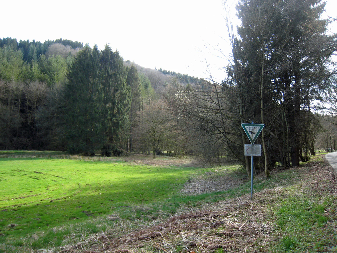
A triangular nature reserve sign on a metal pole positioned next to a green meadow and a wooded hillside.
A nature reserve sign marking the boundary of the Olpebachtal area.

Naturschutzgebiet Olpebachtal history and protected-area timeline

Naturschutzgebiet Olpebachtal was formally established as a nature reserve in 1990, when the lower Olpebach valley and its associated side valleys in the municipality of Kürten were placed under formal protection. The designation recognized the valley as a representative example of the near-natural stream and floodplain systems still to be found in the Bergische Hochflächen and as a habitat complex worthy of conservation management.

The reserve is administered by the Untere Landschaftsbehörde, the lower landscape authority, of the Rheinisch-Bergischer Kreis. It was subsequently integrated into the updated 2012 Landscape Plan for Kürten, which provides the broader planning framework for land use, vegetation development, and habitat protection across the municipality. Within this planning system, Olpebachtal is treated as both a local protected site and an important component of the regional habitat network. No major subsequent designation changes are recorded in the available sources.

Naturschutzgebiet Olpebachtal landscape and geographic character

The landscape of Naturschutzgebiet Olpebachtal is shaped by a single dominant feature: the valley of the Olpebach. The reserve follows the stream through a gently incised section of the Bergische Hochflächen, where wide, flat valley floors alternate with sloping valley sides and short lateral tributary valleys. Elevations within the protected area range from roughly 159 meters to about 216 meters above sea level, with an average around 188 meters, giving the valley a quiet, low-relief profile rather than a dramatic one.

The Olpebach itself runs through the reserve in a near-natural condition, with a broad floodplain flanking it on either side. Sloping valley sides rise from the wetland floor into agricultural land and adjacent forest. Small, steep side valleys, the Siepen, cut into these slopes and funnel additional runoff into the main stream, creating a typical Bergisches Land mosaic of flat-bottomed valley, vegetated slopes, and narrow tributary ravines. The overall impression is of a small but coherent valley landscape, kept open by the wet valley floor and framed by the surrounding uplands of the Bergische Hochflächen.

Naturschutzgebiet Olpebachtal ecosystems, habitats, and plant life

Ecologically, Naturschutzgebiet Olpebachtal is dominated by wet valley habitats. The valley floor is made up of moist grassland in the form of extensive tall-herb fringes lining the stream, dominated by butterbur (Petasites), with meadowsweet-rich (Filipendula) wet fallow vegetation occupying additional parts of the floodplain. These tall-herb communities are characteristic of periodically flooded, nutrient-rich stream-side settings in central European low mountains.

The reserve also includes legally protected biotope types typical of near-natural stream valleys. Small patches of alder swamp woodland, sedge- and rush-rich wet meadows, and seepage spring areas add structural diversity alongside the main stream. A regionally notable ecological challenge is the presence of Himalayan balsam, an invasive neophyte that has established itself in the wet floodplain vegetation. This is explicitly acknowledged in the reserve's management considerations and shapes how the valley's plant communities are being maintained and developed over time.

Naturschutzgebiet Olpebachtal wildlife and species highlights

The available source material for Naturschutzgebiet Olpebachtal does not document specific vertebrate species in detail, and a richly supported wildlife section cannot be assembled from the sources at hand. The reserve's ecological structure, however, indicates the broad wildlife significance of the area.

The combination of a near-natural stream, wet meadows, tall-herb fringes, swamp woodland patches, and seepage springs supports the typical fauna of Bergische Hochflächen stream valleys: aquatic and semi-aquatic invertebrates associated with the brook itself, amphibians that depend on wet meadows and spring seepages, and bird and small-mammal communities that use the tall-herb fringes and adjacent slope woodland. Within the local landscape matrix, Olpebachtal provides one of the more continuous, structurally diverse habitat corridors available in the area, and this corridor role is its principal wildlife-relevant function within the regional ecological network.

Naturschutzgebiet Olpebachtal conservation status and protection priorities

Naturschutzgebiet Olpebachtal is classified as an IUCN Category IV Habitat/Species Management Area, meaning that it is a protected site oriented toward the active conservation of specific habitats and species rather than toward strict non-intervention. The reserve's formal management objectives are clearly defined in its designation documents.

The principal conservation goals are the maintenance and development of a wide, landscape-aesthetically valuable stream-valley system with its side valleys and remarkable scenic character; the protection and safeguarding of legally protected biotopes, including swamp, bog, and alluvial forests, sedge- and rush-rich wet meadows, spring areas, and natural or near-natural sections of running and standing freshwater; the preservation and development of species-rich meadows and wet grassland in the valley floor as habitats for specially adapted flora and fauna; and the securing of the valley's function as a regional habitat linkage of outstanding importance. Additionally, the reserve supports recreational enjoyment of nature within its limits, a purpose written into the German-style protection objectives alongside its ecological aims.

Because of the documented presence of invasive Himalayan balsam, ongoing habitat management also addresses the control and limitation of neophyte spread within the tall-herb floodplain communities. At a broader scale, the reserve is registered in the World Database on Protected Areas under WDPA ID 166022 and forms part of North Rhine-Westphalia's official protected-area inventory, with the NRW Fachinformationssystem listing the site under the code GL-016.

Top sights and standout views in Naturschutzgebiet Olpebachtal

Naturschutzgebiet Olpebachtal's standout quality is the preservation of a near-natural stream valley with a broad floodplain in an otherwise heavily used Bergische Hochflächen landscape. Its protected composition, ranging from butterbur-dominated tall-herb fringes and meadowsweet-rich wet fallows to small alder swamp patches, sedge- and rush-rich wet meadows, and spring areas, gives the reserve a layered ecological character that is unusual at this scale in the region.

The reserve also stands out for its explicit role as a regional habitat linkage. By protecting a continuous valley corridor with its tributary Siepen, it contributes to the broader ecological connectivity of the Rheinisch-Bergischer Kreis. Set against the surrounding agricultural land and forests, Olpebachtal is, in effect, a small but ecologically expressive ribbon of original valley landscape in the Bergisches Land.

Best time to visit Naturschutzgebiet Olpebachtal

The available source material does not provide a detailed, source-supported seasonal profile for visiting Naturschutzgebiet Olpebachtal. In general, such stream-valley reserves in the Bergische Hochflächen are most visually expressive in late spring and summer, when tall-herb fringes along the Olpebach, meadowsweet-rich wet vegetation, and stream-side meadows reach their full seasonal development; spring is also a good period to see the valley floor hydrology at its most active. Visitors interested in autumn coloration of any wetland woodland patches may find the late season atmospheric, though conditions vary year to year.

Monthly climate preview

Long-term average temperature and precipitation rhythm for protected terrain

Naturschutzgebiet Olpebachtal Climate Normals and Monthly Weather Data

Representative coordinate measurements for Naturschutzgebiet Olpebachtal record a measured annual temperature range from sub-zero winter minimums to warm summer maximums alongside steady monthly precipitation. Examining the complete twelve-month climatology profile reveals precise monthly variations in long-term average conditions.
Annual mean9 °C
0 °C18 °C
Jan
Feb
Mar
Apr
May13°
Jun16°
Jul18°
Aug18°
Sep14°
Oct
Nov
Dec
Warmest month
July

18.3 °C

Coolest month
January

0.3 °C

Wettest month
December

3 mm/day

Driest month
April

1.8 mm/day

Park location guide

Geography guide, regional context, and park location map for Naturschutzgebiet Olpebachtal

Naturschutzgebiet Olpebachtal park geography, regions, and map view in Germany

Understand where Naturschutzgebiet Olpebachtal sits in Germany through a broader geographic reading of the surrounding landscape, nearby location context, and its mapped position within the national park landscape.

How Naturschutzgebiet Olpebachtal fits into Germany

Germany is a federal republic in Western and Central Europe with a population of over 83 million across sixteen constituent states. It is Europe's largest economy by nominal GDP and a major global exporter and importer. The capital is Berlin, and the country borders Denmark, Poland, Czech Republic, Austria, Switzerland, France, Luxembourg, Belgium, and the Netherlands.

Wider geography shaping Naturschutzgebiet Olpebachtal in Germany

Germany is located in Western and Central Europe, spanning 357,022 km². It borders Denmark to the north, Poland and the Czech Republic to the east, Austria and Switzerland to the south, and France, Luxembourg, Belgium, and the Netherlands to the west. The country has coastlines on the Baltic Sea and North Sea to the north, with the Alps located in the southern region.

Map view of Naturschutzgebiet Olpebachtal

Use this park location map to pinpoint Naturschutzgebiet Olpebachtal in Germany, understand its exact geographic position, and read its mapped placement within the surrounding landscape more clearly.

Pigeon | © OpenStreetMap contributors

Location context for Naturschutzgebiet Olpebachtal

Nordrhein-WestfalenRheinisch-Bergischer Kreis

Visual reference guide for stream valleys, wet meadows, and protected habitats

Naturschutzgebiet Olpebachtal Photos and Landscape Scenery

Visual records capture the near-natural stream valley, broad floodplains, and wetland woodland mosaics that define Naturschutzgebiet Olpebachtal. Examining field photographs reveals the distinctive protected-area terrain and ecological character of the Bergische Hochflächen uplands.

A triangular nature reserve sign on a metal pole positioned next to a green meadow and a wooded hillside.

Park atlas

Compare adjacent stream valleys and regional protected areas in the Bergisches Land

Parks Near Naturschutzgebiet Olpebachtal and Surrounding Protected Landscapes

Browse other parks near Naturschutzgebiet Olpebachtal to discover connected stream valleys and wetland habitats across the surrounding regional uplands. Expanding the geographic comparison reveals broader protected landscape networks and similar valley ecosystems throughout the region.
Nature reserveNorth Rhine-Westphalia
About 3.9 km away#1 closest

Southwest

Naturschutzgebiet Ölsiefental Protected Area and Stream Valley Map in North Rhine-Westphalia

Representative valley landscape with moist deciduous forest and spring mire habitats

Naturschutzgebiet Ölsiefental preserves a compact yet diverse mosaic of brook, swamp, and floodplain forest. This protected area in North Rhine-Westphalia follows the Ölsiefen stream from its source to the Sülz river, providing a valuable study of intact valley relief, wet meadow ecology, and historical coppice woodland management in the Bergisches Land region.

Area
0.05 km²
Established
1990
IUCN
IV
A horizontal watercolor painting depicting a soft landscape with distant rolling hills, mid-ground green forests, and a foreground area of wetland and water.
Nature reserveNordrhein-Westfalen
About 4.3 km away#2 closest

Southwest

Naturschutzgebiet Alemigsiefental: Nature Reserve Geography and Protected Valley Landscapes

Protected riparian habitat in the Bergisches Land of Germany

Examine the mapped boundaries and natural terrain of Naturschutzgebiet Alemigsiefental. This nature reserve in Nordrhein-Westfalen protects an essential stream corridor, wet meadows, and floodplain forests, serving as a critical habitat within the regional network of protected watercourses.

Area
0.101 km²
Established
1990
IUCN
IV
Relief
Upland
Nature reserveNordrhein-Westfalen
About 6.2 km away#3 closest

West

Naturschutzgebiet Scherfbachtal: Protected Stream Valley and Spring Landscape Analysis

Regional protected geography in Nordrhein-Westfalen

Delve into the protected terrain of Naturschutzgebiet Scherfbachtal, which preserves a rare network of spring basins, wet meadows, and floodplain forests. This site exemplifies the ecological value of small, interconnected valley habitats within the wider Bergisches Land region of North Rhine-Westphalia, providing essential sanctuary for local stream-dependent ecosystems.

Established
2012
IUCN
IV
Watercolor painting of a rolling landscape with soft green hills, forest patches, and a winding stream.
Nature reserveGermany
About 6.8 km away#4 closest

Northeast

Schwarzenbachtal Nature Reserve: Regional Protected Landscape and Stream Valley Atlas

A mapped overview of protected habitats in North Rhine-Westphalia

Schwarzenbachtal serves as a vital protected area in Germany, defined by its elongated brook valley and intricate transitions between wet meadows and dry grassland mosaics. As part of the Bergisches Land stream network, this nature reserve illustrates the ecological significance of small-scale valley landscapes and their role in regional conservation geography.

Area
0.082 km²
Established
2013
Relief
Upland
Climate
Temperate
A horizontal watercolor illustration depicting rolling hills, forest patches, and a soft, hazy valley against a white background.
Nature reserveNorth Rhine-Westphalia
About 6.8 km away#5 closest

North

Mausbachtal Nature Reserve in North Rhine-Westphalia: Protected Stream Valley and Forest Landscapes

Regional stream valley network and deciduous forest landscape

This protected area in the Oberbergischer Kreis offers a window into the Bergische Hochflächen topography. The reserve highlights a mosaic of near-natural beech forest, wet meadows, and floodplain woodland, forming an integral link in the regional stream network connected to the Große Dhünn.

Area
0.237 km²
Established
2013
IUCN
IV
A soft watercolor painting of a pastoral landscape featuring a stream flowing through green meadows and gentle hills under a pale sky.
Nature reserveRheinisch-Bergischer Kreis
About 8.7 km away#6 closest

West

Naturschutzgebiet Scherfbachtal (Odenthal) Protected Area and Stream Valley Map

A preserved riparian landscape in Rheinisch-Bergischer Kreis.

Naturschutzgebiet Scherfbachtal (Odenthal) represents a well-preserved nature reserve spanning five sections of the Scherfbach stream corridor. The area encompasses diverse ecosystems including near-natural meandering brooks, floodplain forests, and steep Siefen side valleys. This protected landscape is defined by its high habitat connectivity, providing a vital network of springs, marshy meadows, and mature woodlands within the Bergisches Land geography.

Area
1.053 km²
Established
1994
IUCN
IV
A soft watercolor illustration of a landscape with green forest tree lines in the foreground, wetland grasses, and pale rolling hills in the background against a white sky.
Nature reserveNordrhein-Westfalen
About 10 km away#7 closest

Southeast

Naturschutzgebiet Schlingenbachtal: Protected Stream Valley and Floodplain Geography

A vital riparian habitat reserve in Nordrhein-Westfalen, Germany

Naturschutzgebiet Schlingenbachtal protects a nearly complete stream-valley ecosystem, featuring an intricate network of wet meadows, alder carr, and forested slopes. By preserving the natural course of the Schlingenbach, the reserve functions as an essential node within regional habitat networks, offering a distinct study in riparian geography and forest land management.

Area
0.689 km²
Established
1988
IUCN
IV
A horizontal watercolor painting showing a peaceful river valley with green meadows, trees on both sides, and soft rolling hills in the background under a warm sky.
Nature reserveRheinisch-Bergischer Kreis
About 10 km away#8 closest

West

Naturschutzgebiet Pfengstbach: Protected Brook Valley and Meadow Landscape Analysis

Regional geography and natural valley terrain of Rheinisch-Bergischer Kreis

Analyze the structural integrity of the Naturschutzgebiet Pfengstbach brook valley, featuring a detailed look at its riparian woodland, seepage springs, and wet meadow distribution. This protected area offers a precise example of Bergisches Land valley morphology, where meadow floors and mixed deciduous slopes intersect within a significant Natura 2000-linked conservation corridor.

Area
18.6 km²
Established
1994
IUCN
IV
Relief
Upland

Common questions about visiting, size, designation, and location context for Naturschutzgebiet Olpebachtal

Naturschutzgebiet Olpebachtal FAQs for park facts, access, geography, and protected area context

Find quick answers about Naturschutzgebiet Olpebachtal, including protected-area facts, park geography, trail and visitor context, and how the park fits into its surrounding country and regional landscape.
MoriAtlas Explorer

Continue Your Protected Areas Search Across the Global Atlas

Deepen your exploration by continuing the structured search for national parks and protected areas worldwide. Utilize the comprehensive filtering capabilities to compare different conservation landscapes and refine your understanding of global park geography. Discover more about the distribution and characteristics of protected natural areas.

Global natural geography