
Mori Atlas logo
Nature reserveNaturschutzgebiet Schmithof

A mapped exploration of limestone quarries, calcareous grasslands, and historical woodland terrain

Naturschutzgebiet Schmithof Protected Nature Reserve and Limestone Landscape Geography

Naturschutzgebiet Schmithof represents a compact yet ecologically distinct protected area situated in Nordrhein-Westfalen. This site serves as a vital case study for regional geography by integrating exposed Devonian limestone strata, remnants of industrial lime production, and species-rich oak-hornbeam forest. The park boundaries encompass a mosaic of calcareous grassland and shrub-filled terrain that highlights centuries of traditional forest management.

nature reservelimestone quarrycalcareous grasslandoak-hornbeam forestcoppice woodlandorchid habitat
A colorful flat-design illustration depicting a waterfall falling over a rocky cliff face, surrounded by a forest and open landscape under a sunlit sky.

Naturschutzgebiet Schmithof

Nature reserve

Park overview

Structured park overview, official facts, and landscape profile for Schmithof Nature Reserve

Schmithof Nature Reserve park facts, protected area profile, and essential visitor context

Review the core facts for Schmithof Nature Reserve, including designation, size, terrain, visitor scale, habitats, and operating context in one park-focused overview.

About Schmithof Nature Reserve

Schmithof Nature Reserve is a compact protected area situated on the western edge of Aachen, in the Städteregion Aachen, in the far west of North Rhine-Westphalia near the border with Belgium and the Netherlands. Although small, the reserve is ecologically dense, combining a former limestone quarry, historic lime-kiln remains, and species-rich broadleaf woodland within a single contiguous area.

The reserve lies west of the Walheim district and forms part of the wider system of nature-protected sites managed by the city of Aachen. Its establishment in 1988 coincided with regional efforts to safeguard small but ecologically significant limestone and woodland habitats that had survived amid a landscape otherwise dominated by agriculture, settlement, and former industrial use. The site is officially catalogued under the NRW nature protection information system with the identifier ACS-010 and is also recorded in the World Database on Protected Areas.

Ecologically, Schmithof illustrates how historical land use can shape biodiversity. The surrounding woodland has developed from coppice management, a traditional form of low-forest harvesting known in German as Niederwaldwirtschaft, which produces open, multi-stemmed stands that favour a rich herb layer. Today the canopy is dominated by oak and hornbeam, interspersed with shrubs, while the forest floor supports a diverse herbaceous layer dominated in places by ivy and Mercurialis perennis (Bingelkraut). On the quarry floor, open calcareous grassland persists, though it is gradually being overtaken by shrubs as natural succession progresses.

The reserve is managed under the Aachen landscape plan by the lower landscape authority of the Städteregion Aachen. Its conservation aims explicitly combine habitat management with the preservation of the quarry itself, recognising both the rare plant and animal communities that depend on the limestone environment and the scientific value of the exposed Devonian rock, which offers a window into the region's tropical marine past.

Quick facts and research context for Schmithof Nature Reserve

Schmithof Nature Reserve lies in Aachen, in the Städteregion Aachen region of North Rhine-Westphalia in western Germany, west of the Walheim district. The protected area covers around 4.8 hectares and was formally designated in 1988 as part of the broader Aachen landscape planning framework.

The reserve is classified under IUCN Category IV as a Habitat/Species Management Area, and is administered by the lower landscape authority of the Städteregion Aachen. Its core feature is a former limestone quarry, accompanied by the historic Schmithof lime kiln, surrounded by species-rich oak-hornbeam woodland developed from long-term low-forest (coppice) management.

Protection and recognition

Documented terrestrial protection metrics and official registry details

Naturschutzgebiet Schmithof Protection Status and Conservation Records

Naturschutzgebiet Schmithof maintains a documented terrestrial protection status within official conservation databases. Archives aggregate international registry records and management scope details for structured atlas analysis.

Protection details

Protection scope
Terrestrial
WDPA ID
165441
Park context

Deeper park guide and search-rich context for Schmithof Nature Reserve

Schmithof Nature Reserve history, landscape, wildlife, and travel context

Explore Schmithof Nature Reserve through its history, landscape character, ecosystems, wildlife, conservation priorities, cultural context, and seasonal travel timing in a structured park guide built for atlas discovery and search intent.

Why Schmithof Nature Reserve stands out

Schmithof is best known for its combination of a former limestone quarry with a richly structured broadleaf forest developed from centuries of coppice woodland use. The quarry floor exposes Devonian limestone, creating the calcareous substrate that supports lime-loving plant communities, including orchids and other rare species that depend on thin, nutrient-poor chalk grassland soils. The reserve is also notable for its embedded industrial heritage, the Schmithof lime kiln, which illustrates the historical use of the local limestone resources. Together, the geological exposure, the calcareous grassland succession, and the surrounding oak-hornbeam forest give this small reserve a clearly defined scientific and conservation profile.
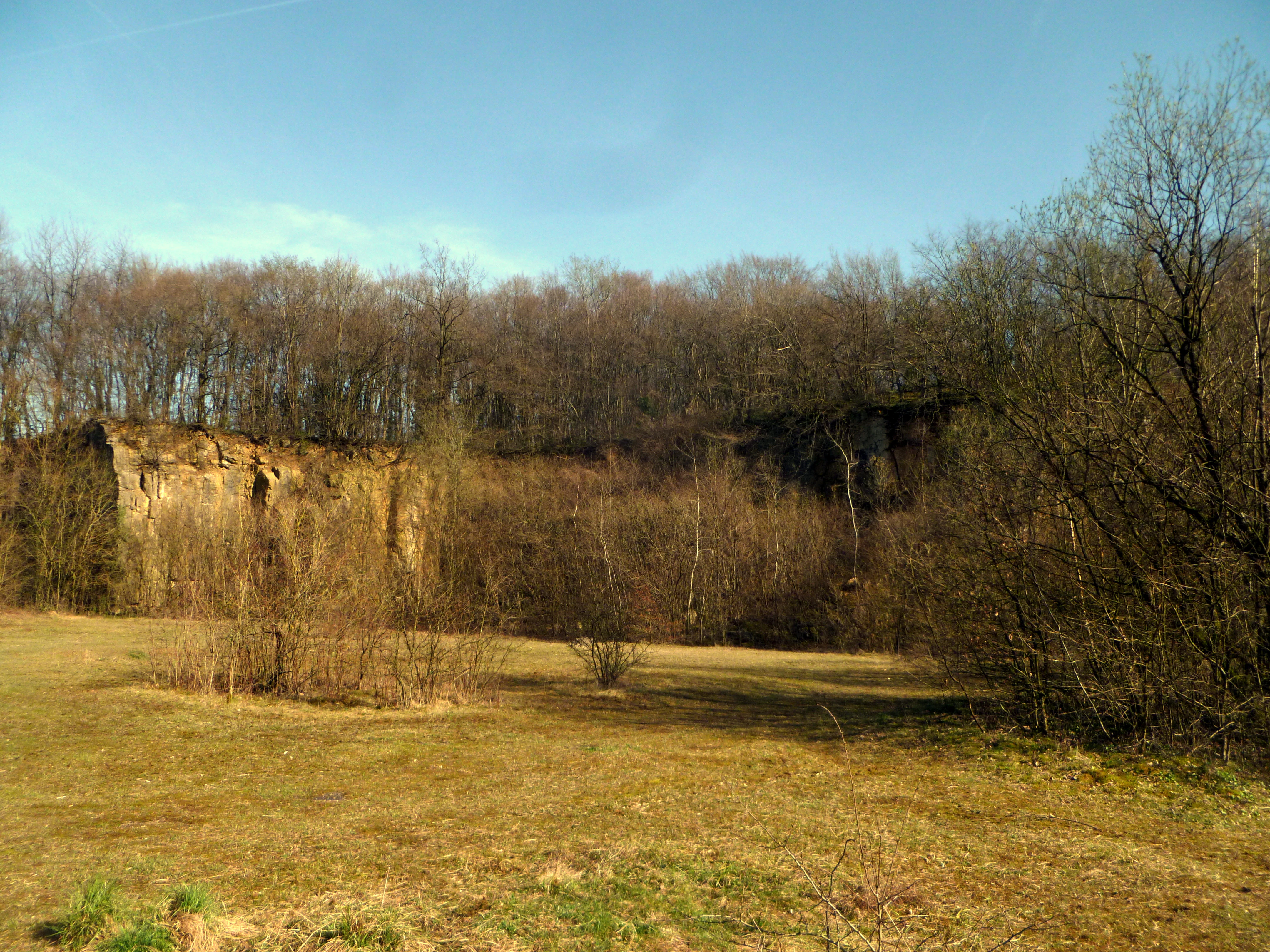
A meadow in the foreground leads to a rocky quarry face topped by a dense forest in the background.
A view of the former quarry within the Naturschutzgebiet Schmithof nature reserve.

Schmithof Nature Reserve history and protected-area timeline

The reserve's history is closely tied to the industrial and forestry traditions of the Aachen region. The quarry at Schmithof was historically operated as a source of limestone, and the Schmithof lime kiln reflects the local tradition of burning the extracted rock into quicklime for use in construction and agriculture. As these operations ceased, the quarry was left as an open exposure, allowing natural processes to colonise the bare rock and shallow soils that had been created or disturbed by extraction.

The surrounding woodland developed under centuries of Niederwaldwirtschaft, a form of coppice management in which broadleaf trees such as oak and hornbeam are repeatedly cut back to produce a continuous supply of small-diameter wood. This long history of human management is itself part of the site, shaping the species composition and structure of today's forest.

In 1988, the area was formally designated as a nature reserve (Naturschutzgebiet), integrating the quarry, kiln remains, and surrounding woodland into the protected-area system of North Rhine-Westphalia. The designation aligned with broader landscape-planning efforts under the Aachen landscape plan, and the reserve has since been managed by the lower landscape authority of the Städteregion Aachen as a Habitat/Species Management Area under IUCN Category IV.

Schmithof Nature Reserve landscape and geographic character

The landscape of Schmithof is shaped by an abrupt geological feature within an otherwise gentle wooded valley setting. The former limestone quarry forms a bowl in the terrain, with exposed rock faces and ramps leading down to a flatter quarry floor where thin, lime-rich soils have developed. These soils support a patch of calcareous grassland, or Kalkmagerrasen, that is slowly being encroached by woody species.

Around and above the quarry, the terrain is covered by broadleaf woodland on gently sloping ground. The woodland is structurally varied, with areas of denser canopy interspersed with shrubby patches. Where the canopy is more open, a rich herb layer thrives on the calcareous substrate, whereas denser stands shade out the ground vegetation. The combination of open rock, dry grassland, shrub thicket, and closed forest in close proximity creates a small but topographically diverse mosaic.
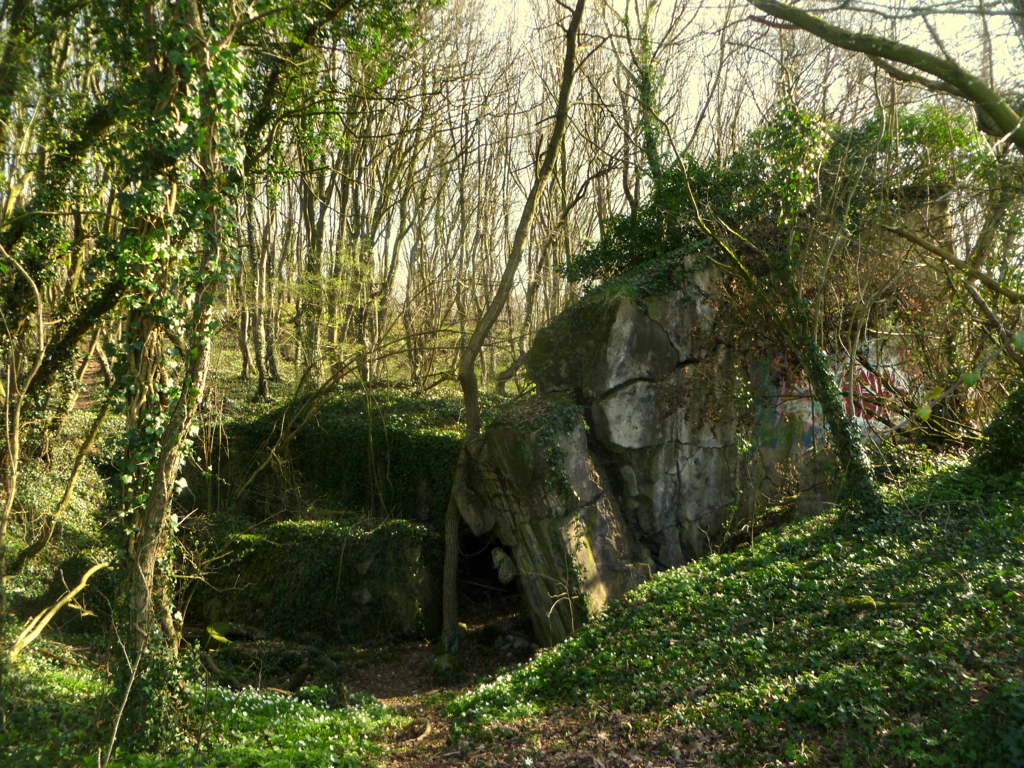
A heavily weathered, concrete military bunker partially covered by moss and forest vegetation, situated within a sparse woodland.
Remnants of a former bunker overtaken by nature in the Schmithof Nature Reserve.

Schmithof Nature Reserve ecosystems, habitats, and plant life

Ecologically, the reserve is notable for the close coexistence of two contrasting habitat types: species-rich broadleaf forest on deeper soils, and open calcareous grassland on the thin, lime-rich soils of the quarry floor. The woodland belongs to the oak-hornbeam forest community typical of the lower mountain regions of western Germany, but its structure has been shaped by former coppice management.

The herb layer is particularly well developed in the more open forest areas, with ivy and Bingelkraut among the characteristic species, and shrubs scattered throughout the stand. On the quarry floor, the lime-rich substrate supports a calcareous grassland community, including rare plants such as orchids, which depend on the nutrient-poor, dry conditions that limestone produces. Over time, the grassland is being colonised by shrubs, a typical succession pattern that requires active management if the open calcareous flora is to be preserved.

The reserve's habitat mosaic is intentionally maintained as part of its IUCN Category IV management approach, balancing the protection of closed woodland with the preservation of the more specialised open limestone habitats.

Schmithof Nature Reserve wildlife and species highlights

Information specifically on fauna in the source material is limited. The reserve's designation document refers to the presence of endangered animal species (gefährdete Tierarten) as part of the rationale for protection, and the habitat mosaic supports those species indirectly: open calcareous grassland and warm rock faces provide habitat for invertebrates, including the pollinators that depend on orchids and other lime-loving plants, while the surrounding oak-hornbeam woodland offers nesting and foraging habitat for woodland birds and small mammals.

Because the reserve is small and embedded in a broader landscape of forest and settlement, its wildlife value is closely tied to connectivity with neighbouring habitats rather than to large home-ranging species. The detailed species inventory is not extensively documented in the publicly available source.

Schmithof Nature Reserve conservation status and protection priorities

Schmithof's conservation significance lies in the protection of a small, self-contained example of calcareous habitat in a region where such substrates are scarce. The reserve safeguards a former quarry whose exposed Devonian limestone supports both scientifically important geological outcrops and a specialised flora of calcareous grassland, including rare species such as orchids.

Designated in 1988 under the NRW nature protection framework and now classified as an IUCN Category IV Habitat/Species Management Area, the reserve is managed with the explicit goal of maintaining both the quarry itself and the biological communities it hosts. Conservation management must address the gradual succession of shrubs into the calcareous grassland, which, if unchecked, would eventually close over the open habitats that rare plants depend upon. At the same time, the surrounding woodland, shaped by centuries of coppice use, represents a cultural-ecological heritage that the reserve also protects.

The site is embedded in the larger landscape-planning approach of Aachen, recognising that even very small protected areas can make a meaningful contribution to regional biodiversity when they protect habitat types that are otherwise under-represented in the surrounding landscape.

Schmithof Nature Reserve cultural meaning and human context

The reserve carries a layered cultural dimension rooted in the rural and industrial history of the Aachen region. The Schmithof lime kiln stands as a tangible reminder of small-scale lime production that once utilised the local limestone, an activity that shaped both the local economy and the very geology of the site through quarrying. Remains of a former bunker within the protected area further reflect 20th-century layers of the landscape.

The surrounding woodland also embodies a long tradition of Niederwaldwirtschaft, a form of communal coppice forestry once widespread in western German low mountain regions. Although that management regime is no longer active, its ecological legacy continues to define the forest's character and connects the site to centuries of human interaction with the local landscape.

Top sights and standout views in Schmithof Nature Reserve

Schmithof Nature Reserve offers a compact but unusually varied combination of geological exposure, rare calcareous flora, industrial heritage, and species-rich broadleaf woodland, all within a few hectares just west of Aachen. Its most distinctive highlights are the exposed Devonian limestone of the former quarry, the patches of calcareous grassland that still host rare plants such as orchids, and the oak-hornbeam forest shaped by centuries of coppice management. The historic Schmithof lime kiln adds a human-history layer to what is fundamentally a small but well-defined Habitat/Species Management Area.

Best time to visit Schmithof Nature Reserve

The reserve's atmosphere varies with the seasons in line with its mix of woodland and open calcareous habitats. Late spring and early summer are typically the most rewarding period to observe the open calcareous grassland, when orchids and other lime-loving herbs are flowering and the herb layer in the more open woodland is fully developed. Autumn draws attention to the broadleaf canopy of oak and hornbeam, while winter reveals the structural contrast between bare rock faces, shrubby succession, and closed forest.

These visits are best understood as low-key walks through a small, ecologically sensitive site rather than as tourism excursions; the reserve's conservation priorities, particularly the protection of rare calcareous flora, mean that any visit should aim to minimise disturbance to the quarry floor and its surrounding vegetation.

Monthly climate preview

Long term temperature and precipitation records measured at representative coordinates

Naturschutzgebiet Schmithof Climate Normals and Annual Weather Patterns

Historical climate normals for Naturschutzgebiet Schmithof track recorded monthly temperature ranges and precipitation averages from NASA Power datasets. Detailed monthly comparisons provide complete statistical visibility into long term meteorological conditions across the protected terrain.
Annual mean8 °C
0 °C17 °C
Jan
Feb
Mar
Apr
May11°
Jun15°
Jul17°
Aug17°
Sep13°
Oct
Nov
Dec
Warmest month
July

17 °C

Coolest month
January

-0 °C

Wettest month
December

3.1 mm/day

Driest month
April

1.9 mm/day

Park location guide

Geography guide, regional context, and park location map for Schmithof Nature Reserve

Schmithof Nature Reserve park geography, regions, and map view in Germany

Understand where Schmithof Nature Reserve sits in Germany through a broader geographic reading of the surrounding landscape, nearby location context, and its mapped position within the national park landscape.

How Schmithof Nature Reserve fits into Germany

Germany is a federal republic in Western and Central Europe with a population of over 83 million across sixteen constituent states. It is Europe's largest economy by nominal GDP and a major global exporter and importer. The capital is Berlin, and the country borders Denmark, Poland, Czech Republic, Austria, Switzerland, France, Luxembourg, Belgium, and the Netherlands.

Wider geography shaping Schmithof Nature Reserve in Germany

Germany is located in Western and Central Europe, spanning 357,022 km². It borders Denmark to the north, Poland and the Czech Republic to the east, Austria and Switzerland to the south, and France, Luxembourg, Belgium, and the Netherlands to the west. The country has coastlines on the Baltic Sea and North Sea to the north, with the Alps located in the southern region.

Map view of Schmithof Nature Reserve

Use this park location map to pinpoint Schmithof Nature Reserve in Germany, understand its exact geographic position, and read its mapped placement within the surrounding landscape more clearly.

Pigeon | © OpenStreetMap contributors

Location context for Schmithof Nature Reserve

Nordrhein-Westfalen

Visual reference guide to exposed Devonian limestone and oak hornbeam habitats

Naturschutzgebiet Schmithof Photos and Landscape Scenery Exploration

Visual records reveal the rugged terrain and rare calcareous grassland habitats of Naturschutzgebiet Schmithof. Examining field photographs helps researchers understand the complex geological and ecological character of the protected area.

A meadow in the foreground leads to a rocky quarry face topped by a dense forest in the background.

An old, stone lime kiln structure partially obscured by bare deciduous trees and brush in a forest setting.

A heavily weathered, concrete military bunker partially covered by moss and forest vegetation, situated within a sparse woodland.

Park atlas

Compare surrounding landscapes, limestone formations, and regional woodland reserves

Other Parks Near Naturschutzgebiet Schmithof for Regional Protected Area Discovery

Browse protected areas near Naturschutzgebiet Schmithof to examine related geological features and broadleaf woodland habitats. Expanding the search across the surrounding region reveals connected conservation landscapes and similar regional nature reserves.
A soft watercolor illustration showing a winding river flowing through a forested valley with gentle rolling hills in the background.
Nature reserveGermany
About 2.8 km away#1 closest

South

Naturschutzgebiet Oberlauf der Inde im Münsterwald: Germany Protected Nature Reserve Atlas

Headwater streams and rare wetland habitats in the Aachen region.

Situated in the Münsterwald near Aachen, this nature reserve protects the intact headwaters of the Inde and Fobisbach streams. The area is characterized by a complex, compact landscape of alder carr, spring-fed bogs, and Molinia grasslands, offering a rare window into the natural hydrology and wetland vegetation of the region.

Area
0.299 km²
Established
1988
Relief
Upland
Climate
Temperate
A wide panoramic watercolor painting showing a landscape with a winding light green river or meadow in the foreground, a band of green trees in the middle ground, and purple mountains in the background against a white sky.
Nature reserveNordrhein-Westfalen
About 5.2 km away#2 closest

Northeast

Naturschutzgebiet Schomet: Mapping the Protected Limestone Ridge and Reclaimed Quarry Landscapes

Nature reserve geography in Stolberg, Nordrhein-Westfalen

Examine the distinct geomorphology of Naturschutzgebiet Schomet, where abandoned Carboniferous limestone quarries have evolved into sheltered refuges for hornbeam forest and spring flora. This protected area offers insight into the regional geology of the Eifel foothills, showcasing how human-modified landscapes serve as important ecological corridors for amphibians and rare butterfly species within the broader Stolberg municipal network.

Area
12.81 km²
Established
2005
IUCN
IV
A watercolor painting depicting rolling, soft-toned green hills and a foreground of trees and riparian vegetation.
Nature reserveNorth Rhine-Westphalia
About 6.9 km away#3 closest

Southeast

Laubwald am Hasselbachgraben Nature Reserve in North Rhine-Westphalia

Protected Eifel forest and riparian stream landscape

Located in the Städteregion Aachen, Laubwald am Hasselbachgraben preserves a distinct mix of European beech, oak, and spruce. The reserve is anchored by the Hasselbach stream valley and the landmark Kreitzberg Naturwaldzelle, providing a critical study of near-natural woodland structure within the northern Eifel region.

Area
2.88 km²
Established
1999
IUCN
IV
Relief
Upland
Nature reserveGermany
About 6.9 km away#4 closest

Northwest

Wurmtal Nature Reserve: Mapping the Protected River Valley and Floodplain Geography

Protected riparian habitat in North Rhine-Westphalia

Wurmtal protects a diverse river corridor characterized by free-meandering stretches, soft-wood floodplain forests, and distinct industrial-heritage landmarks. This atlas entry provides insight into the valley's structural geography, including its steep erosion cliffs, gravel-bed river dynamics, and role as a significant ecological migration route within the regional landscape.

Established
1989
Relief
Lowland
Scope
Terrestrial
Water
Water-dominated
A watercolor painting showing a soft green landscape with rolling hills, a small pond, and trees under a white background.
Nature reserveStädteregion Aachen
About 7.3 km away#5 closest

Northeast

Naturschutzgebiet Schlangenberg: A Geographic Profile of Protected Mining Landscapes

Rare heavy metal habitats in the Städteregion Aachen

Naturschutzgebiet Schlangenberg serves as a protected ecological island featuring specialized Galmei flora that thrives on toxic zinc-rich soils. The reserve offers a clear look at how geological formation and historic mining practices created a unique steppe-like terrain, supporting diverse butterfly populations and rare botanical species within the North Rhine-Westphalia landscape.

Area
1.237 km²
Established
1975
IUCN
IV
Relief
Upland
A soft watercolor painting showing a meandering stream winding through green meadows and trees with distant purple hills.
Nature reserveNorth Rhine-Westphalia
About 7.9 km away#6 closest

North

Münsterbusch zwischen Hamm und Haumühle Nature Reserve: Geography and Protected Landscapes

Ecological terrain and Inde valley floodplain mapping

Located in the Städteregion Aachen, Münsterbusch zwischen Hamm und Haumühle offers a compact yet diverse protected terrain. This nature reserve maps as a valuable corridor of oak-hornbeam forests, wet meadows, and specialized grasslands, showcasing the intersection of industrial history and botanical heritage within western Germany.

Established
2004
IUCN
IV
A watercolor painting showing a soft, pastel-colored landscape with a wetland in the foreground and gentle, rolling hills in the background.
Nature reserveNordrhein-Westfalen
About 9.2 km away#7 closest

Southeast

Hoscheider Venn mit Quellgebieten des Dreiläger- und Schleebaches Nature Reserve Atlas

Protected raised bog and glacial pingo terrain in North Rhine-Westphalia

Hoscheider Venn mit Quellgebieten des Dreiläger- und Schleebaches safeguards a representative upland moor environment on the western edge of the Eifel. The reserve includes diverse habitats ranging from nutrient poor bog pools to acidophilous forests, maintaining active restoration zones for regenerating wet heath and peatland ecosystems across its unique topographic mosaic.

Area
1.96 km²
Established
1982
IUCN
IV
Relief
Upland
Nature reserveNorth Rhine-Westphalia
About 10 km away#8 closest

Southeast

Wollerscheider Venn: Mapping the Protected Peatland and Bog Terrain of North Rhine-Westphalia

A specialized wetland reserve on the Eifel border high plateau

Located in the municipality of Simmerath, Wollerscheider Venn preserves essential fragments of raised bog and swamp woodland within the larger Hohes Venn ecosystem. This reserve protects diverse habitats including juniper heath and Nardus grassland, serving as a critical refuge for bog-specialist butterflies and dragonflies in the Eifel region. Its mapped landscape offers a clear view into the conservation of rare peatland environments across western Germany.

Area
0.42 km²
Established
1961
IUCN
IV

Common questions about visiting, size, designation, and location context for Schmithof Nature Reserve

Schmithof Nature Reserve FAQs for park facts, access, geography, and protected area context

Find quick answers about Schmithof Nature Reserve, including protected-area facts, park geography, trail and visitor context, and how the park fits into its surrounding country and regional landscape.
MoriAtlas Explorer

Continue Your Protected Areas Search Across the Global Atlas

Deepen your exploration by continuing the structured search for national parks and protected areas worldwide. Utilize the comprehensive filtering capabilities to compare different conservation landscapes and refine your understanding of global park geography. Discover more about the distribution and characteristics of protected natural areas.

Global natural geography