
Mori Atlas logo
Nature reserveNaturschutzgebiet Schwarzbachsystem mit Haberg und Krenkeltal

Understanding the mapped landscape, stream networks, and diverse habitat mosaics of this protected Sauerland region.

Naturschutzgebiet Schwarzbachsystem mit Haberg und Krenkeltal: A Detailed Geographic Atlas Entry

Discover the complex landscape of Naturschutzgebiet Schwarzbachsystem mit Haberg und Krenkeltal, a nature reserve in the Sauerland region of North Rhine-Westphalia. This protected area centers on a branched lowland brook system characterized by hillside spring mires, alder floodplain forests, and rare juniper heathlands. The reserve forms a critical ecological mosaic that supports diverse water-dependent species and provides shelter within its undisturbed valleys.

brook systemlow mountain streamSauerlandalder floodplain forestbog and swamp woodlandjuniper heath
A flat-style digital illustration depicting a waterfall dropping from a cliff into a stream, flanked by coniferous trees and birch trees in a mountain valley.

Naturschutzgebiet Schwarzbachsystem mit Haberg und Krenkeltal

Nature reserve

Park overview

Structured park overview, official facts, and landscape profile for Naturschutzgebiet Schwarzbachsystem mit Haberg und Krenkeltal

Naturschutzgebiet Schwarzbachsystem mit Haberg und Krenkeltal park facts, protected area profile, and essential visitor context

Review the core facts for Naturschutzgebiet Schwarzbachsystem mit Haberg und Krenkeltal, including designation, size, terrain, visitor scale, habitats, and operating context in one park-focused overview.

About Naturschutzgebiet Schwarzbachsystem mit Haberg und Krenkeltal

The Naturschutzgebiet Schwarzbachsystem mit Haberg und Krenkeltal lies in the Sauerland foothills of North Rhine-Westphalia, on the western side of the Rüspe valley in the municipality of Kirchhundem. It encompasses a chain of narrow valleys shaped by the Schwarzbach and its tributaries, the most prominent of which is the Meinscheidbach. Its core geographical identity is the close interweaving of running water, groundwater-driven habitats, and the surrounding forested slopes and small open areas. The six separate parcels reflect both the linear extent of the stream network and the historical patchwork of land use typical of older Westphalian valley landscapes.

Protected for the first time in 1961 and supplemented by a further ordinance in 2003 by the Bezirksregierung Arnsberg, the reserve represents one of the more sustained efforts to conserve a Sauerland brook system in this part of the Kreis Olpe. Its FFH designation (DE-4915-302) underscores that the same qualities that justify national protection also meet the standards of the European Habitats Directive, in particular the integrity of the stream ecosystem, the alder and bog woodland communities, and the supporting open habitat mosaic.

For visitors and researchers, the area is fundamentally a stream-and-valley protected landscape rather than a high-mountain or coastal one. The terrain is shaped by modest elevation, gentle slopes, and the strong control that water and soil moisture exert over vegetation. The valley is bordered to the east by the boundary with the Kreis Siegen-Wittgenstein, while to the north lies the much-visited Panorama-Park Sauerland Wildpark, placing the reserve within a wider landscape of nature-based tourism, forestry and traditional agriculture that has, in many places, left this particular brook system unusually intact.

Quick facts and research context for Naturschutzgebiet Schwarzbachsystem mit Haberg und Krenkeltal

The Naturschutzgebiet Schwarzbachsystem mit Haberg und Krenkeltal is a German nature reserve (Naturschutzgebiet, NSG) of roughly 312 hectares that was designated in stages in 1961 and 2003 by the Bezirksregierung Arnsberg. It is located in the municipality of Kirchhundem in the Kreis Olpe, in the state of North Rhine-Westphalia, and adjoins the boundary with the Kreis Siegen-Wittgenstein.

The reserve is made up of six distinct parcels that together protect the branched stream system of the Schwarzbach, a tributary of the Eder, and its tributaries including the Meinscheidbach. About 311 hectares were simultaneously designated as a European FFH site under the code DE-4915-302. The reserve lies south of the Panorama-Park Sauerland Wildpark and forms part of the protected-area network of southwestern Westphalia.

Protection and recognition

Documented terrestrial protection scope and conservation designation facts

Naturschutzgebiet Schwarzbachsystem mit Haberg und Krenkeltal Protection Status

Terrestrial protection status and management scope for Naturschutzgebiet Schwarzbachsystem mit Haberg und Krenkeltal remain documented without imported international recognition sources. Structured preservation records outline the established conservation framework for the protected landscape.

Protection details

Protection scope
Terrestrial
Park context

Deeper park guide and search-rich context for Naturschutzgebiet Schwarzbachsystem mit Haberg und Krenkeltal

Naturschutzgebiet Schwarzbachsystem mit Haberg und Krenkeltal history, landscape, wildlife, and travel context

Explore Naturschutzgebiet Schwarzbachsystem mit Haberg und Krenkeltal through its history, landscape character, ecosystems, wildlife, conservation priorities, cultural context, and seasonal travel timing in a structured park guide built for atlas discovery and search intent.

Why Naturschutzgebiet Schwarzbachsystem mit Haberg und Krenkeltal stands out

The reserve is best known for its near-natural, highly branched low mountain stream system and its closely linked mosaic of small-scale habitats. Spring-fed hillside mires, alder floodplain forest along the brooks, birch and alder swamp woodland, juniper and matgrass heaths, and wet, moist and nutrient-poor grassland patches all occur in close proximity to the watercourses. It is also recognized for its rare and ecologically demanding species associated with clean running water, mature broadleaf and mixed woodland, and quiet, undisturbed valleys. The combination of an intact brook network, old bog woodland and a disused railway tunnel that serves as a bat hibernation site gives the protected area a distinct, layered conservation significance.
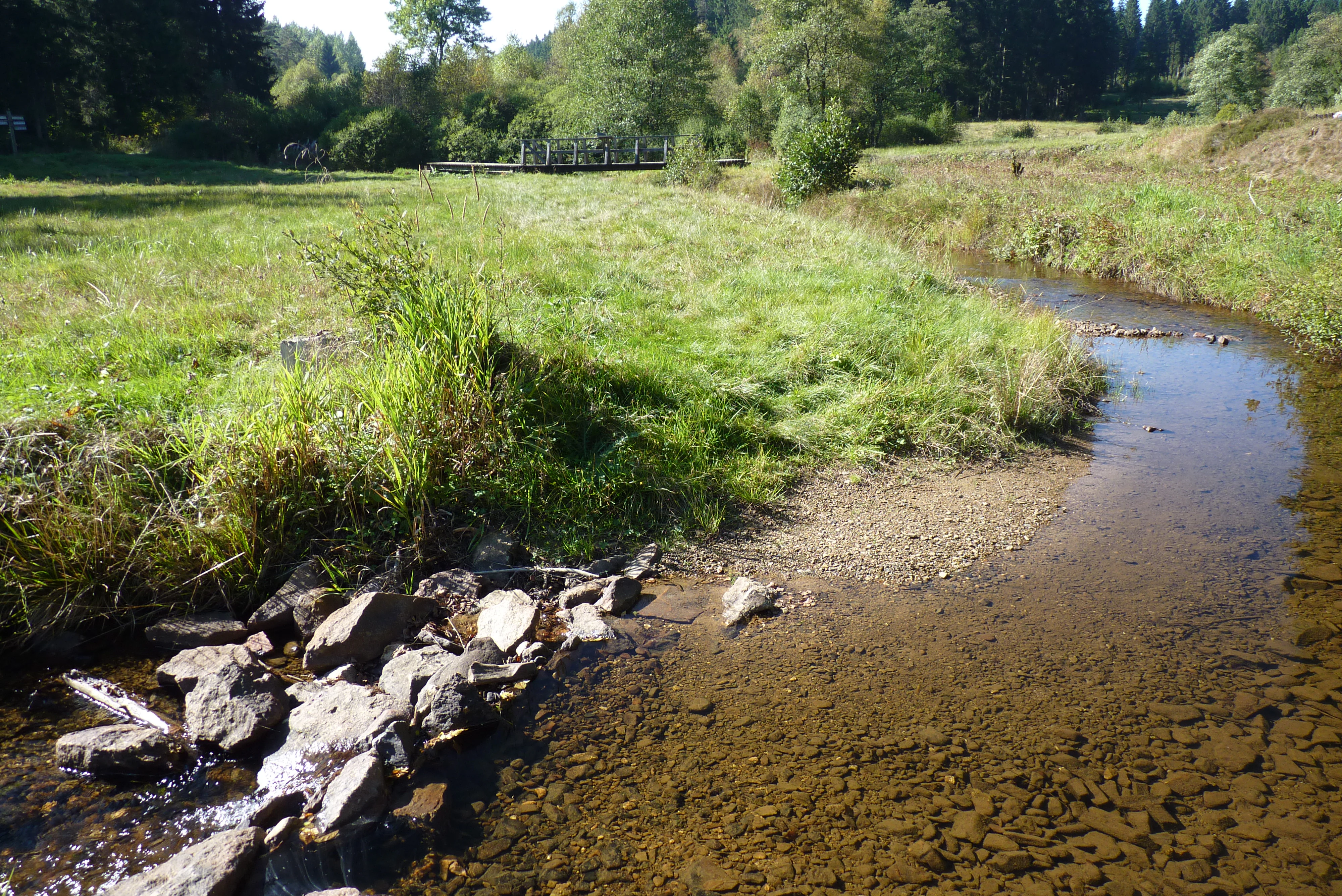
A clear, shallow stream meanders through a grassy meadow, with a rocky stream bed in the foreground and dense forest in the background.
The Schwarzbach stream flowing through the wetland meadows of the nature reserve.

Naturschutzgebiet Schwarzbachsystem mit Haberg und Krenkeltal history and protected-area timeline

The Schwarzbachsystem mit Haberg und Krenkeltal was first placed under formal protection as a Naturschutzgebiet by the Bezirksregierung Arnsberg in 1961, reflecting an early recognition of the ecological value of the Schwarzbach brook system and its adjoining habitats. As part of broader efforts to safeguard representative Sauerland brook landscapes, the initial designation established the legal framework that continues to govern land use, forestry and watercourse management in the area.

In 2003, the Bezirksregierung Arnsberg issued a further ordinance that expanded and reorganized the reserve, resulting in the current configuration of six separate parcels and the present boundaries. Around the same period, approximately 311 hectares were also designated as a European Fauna-Flora-Habitat (FFH) site under the code DE-4915-302, aligning the national protection regime with European habitat conservation requirements. The dual designation brought the area into the Natura 2000 framework and emphasized the importance of its stream, woodland and mire habitats at a continental scale.

The repeated designation over more than four decades reflects the perception of the valley as a near-natural reference system within its region. The historical presence of a disused railway tunnel between Krenkel and the Schwarzbachtal, now repurposed by bats as a winter roost, has become a notable feature of the reserve's conservation history, illustrating how abandoned infrastructure can be integrated into long-term habitat protection.

Naturschutzgebiet Schwarzbachsystem mit Haberg und Krenkeltal landscape and geographic character

The landscape of the reserve is defined by a strongly branched, low-energy stream network carved into the rolling terrain of the eastern Sauerland. The main axis is the valley of the Schwarzbach, a tributary of the Eder, supplemented by smaller side brooks such as the Meinscheidbach and the various headwater streams that originate on the valley flanks. Slopes are typically moderate rather than steep, and the brooks occupy narrow, sinuous corridors that create a shifting mosaic of wet ground, gravel banks and forested edges.

Above the watercourses, the land rises into wooded hills carrying a mix of conifer plantations and more natural broadleaf and mixed stands. The geological substrate, combined with persistent seepage from the slopes, produces conditions for hillside spring mires and peat-influenced soils, which in turn shape the surrounding vegetation. Geomorphic features such as incised stream channels, spring hollows, and small valley basins give the protected area its characteristic relief.

Human traces remain present but secondary. Past agricultural use has left a pattern of small clearings, juniper heath remnants and matgrass-dominated slopes, while the older railway line between Krenkel and the Schwarzbachtal has been naturally reclaimed, with its tunnel now embedded in the landscape as a sheltered, microclimatically stable site.

Naturschutzgebiet Schwarzbachsystem mit Haberg und Krenkeltal ecosystems, habitats, and plant life

Ecologically, the reserve is best understood as a hydrologically driven habitat mosaic. Groundwater seepage and the regular flow of the brooks sustain hillside spring mires (Hangquellmoore), which feed into the stream network and support adjoining swamp and bog woodland communities. The combination of these wet habitats with drier, nutrient-poor slopes is one of the core conservation assets of the area.

Along the brooks themselves, alder-dominated floodplain forests (Erlen-Auenwälder) and fringes of riparian shrubs stabilize the banks and shade the water. Higher on the slopes, birch and alder bog and mire forests (Birken- und Erlen-Bruch- und Moorwälder) occupy the more waterlogged areas. Where former land use has opened up the canopy, juniper heaths and matgrass swards (Borstgrasrasen) persist as semi-open communities of high botanical value.

Further habitat types within the reserve include richly structured wet tall-herb vegetation (feuchte Hochstaudenfluren), small and large sedge stands (Klein- und Großseggenriede), abandoned wet, moist and nutrient-poor fields (Feucht- und Magerbrachen), and actively used wet, moist and nutrient-poor grassland. The coexistence of these habitats in close proximity gives the protected area a layered ecological character that supports both specialized and more generalist species.

Naturschutzgebiet Schwarzbachsystem mit Haberg und Krenkeltal wildlife and species highlights

The wildlife profile of the reserve is shaped by the integrity of the stream system and the presence of mature, structurally diverse woodland. The clean, gravelly and structured reaches of the Schwarzbach and its tributaries support sensitive fish species such as the bullhead (Groppe) and the brook lamprey (Bachneunauge), both of which are indicators of high water quality and natural hydromorphology.

Bats are a particularly important group within the protected area. The disused railway tunnel between Krenkel and the Schwarzbachtal serves as a major winter roost, and the surrounding woodland supports summer populations of species such as the greater mouse-eared bat (Großes Mausohr), the Daubenton's bat (Wasserfledermaus), the brandt's bat (Große Bartfledermaus) and the brown long-eared bat (Braunes Langohr). The mix of open hunting grounds over brooks and meadows and the dark, stable roosting conditions in the tunnel are central to this bat assemblage.

Birds associated with old woodland and quiet valleys are also present, including the black woodpecker (Schwarzspecht), the boreal owl / Tengmalm's owl (Raufußkauz), and the black stork (Schwarzstorch). The kingfisher (Eisvogel) is found along the brooks themselves, while the great grey shrike, in its northern form (Raubwürger), occupies more open sections of the slopes and former farmland. Together these species indicate a landscape where both aquatic and terrestrial habitat quality have been maintained to a high degree.

Naturschutzgebiet Schwarzbachsystem mit Haberg und Krenkeltal conservation status and protection priorities

From a conservation perspective, the reserve is significant because it protects a complete, near-natural low mountain stream system along with its associated wetland, woodland and open habitats. Many German brooks in comparable valley settings have been straightened, deepened or otherwise hydrologically altered; the Schwarzbach system retains an unusually high degree of natural structure, including meandering courses, gravel beds, spring mires and natural bank communities. This makes the area important as a reference site for brook restoration efforts elsewhere in the region.

Its parallel designation as an FFH site (DE-4915-302) further underlines its international significance. The Habitats Directive framework requires that the site be maintained in a favourable conservation status, which reinforces the protection of habitats such as alder floodplain forest, bog and swamp woodland, juniper heath and various types of fen and wet grassland. The conservation regime therefore combines national NSG rules with European reporting and monitoring obligations.

The conservation value of the area is also enhanced by the bat hibernation tunnel, which provides a microclimatically stable and predator-safe refuge for several bat species during the critical winter period. The presence of breeding and wintering populations of niche woodland and wetland species such as the black stork, the kingfisher and the various bats demonstrates that the site is not only structurally intact but also functionally important for population persistence at the regional scale.

Naturschutzgebiet Schwarzbachsystem mit Haberg und Krenkeltal cultural meaning and human context

The reserve lies in a part of the Sauerland where traditional land use has long combined small-scale agriculture, forestry and local water management. The presence of juniper heaths, matgrass swards and small meadows on the slopes reflects centuries of grazing, mowing and land abandonment, and the patterns that remain today are largely a legacy of these older practices.

A small but evocative cultural element is the disused railway line between Krenkel and the Schwarzbachtal, whose tunnel has been reclaimed by nature. While the railway itself is a product of 19th- and 20th-century industrial infrastructure, it has become part of the cultural and natural heritage of the area, illustrating how industrial remains in rural valleys can be reassigned to ecological use.

The village of Rüspe and the wider municipality of Kirchhundem frame the reserve in a regional context of dispersed Sauerland settlements, where communities have historically depended on forestry, livestock and water-based resources. The protected area today sits within this cultural landscape, and its conservation is closely tied to the continued viability of traditional, low-intensity land use on the surrounding slopes.

Top sights and standout views in Naturschutzgebiet Schwarzbachsystem mit Haberg und Krenkeltal

Standout features of the reserve include its six-part structure protecting the entire branched valley system of the Schwarzbach, the persistence of hillside spring mires and alder swamp forests along the watercourses, and the intact juniper and matgrass heaths that recall the area's older agricultural character. The combination of these habitats with the clean, structured brooks sets the reserve apart from more typical forested Sauerland landscapes.

Equally distinctive is the disused railway tunnel between Krenkel and the Schwarzbachtal, which functions as a major bat hibernation site and links industrial heritage to contemporary conservation. Together with the European FFH status under code DE-4915-302, this combination of stream, woodland, open habitat and built infrastructure gives the protected area a layered identity that is unusual within the broader network of North Rhine-Westphalian nature reserves.

Best time to visit Naturschutzgebiet Schwarzbachsystem mit Haberg und Krenkeltal

The reserve is best experienced in the warmer half of the year, when the brook system, mires and deciduous woodland are biologically most active. Late spring and early summer bring rich vegetation in the alder floodplain forest and on the wet meadows, while the sedge stands and tall-herb communities are at their most visible. Bird activity, including the calls of black woodpeckers and the hunting flights of kingfishers along the brooks, is also more conspicuous during this period.

Autumn is attractive for the changing colors of the alder and birch woodland and for the seasonal movement of bats into the railway tunnel for hibernation. Winter visits focus less on plant life and more on the quiet atmosphere of the valley and the often-frozen brooks, though the protected site remains primarily a conservation area rather than a heavily developed visitor attraction, and conditions underfoot can be wet and slippery throughout much of the year on the slopes and in the mires.

Monthly climate preview

Long term temperature normals and monthly precipitation patterns from representative coordinates

Naturschutzgebiet Schwarzbachsystem mit Haberg und Krenkeltal Climate and Weather by Month

Long term climate records for Naturschutzgebiet Schwarzbachsystem mit Haberg und Krenkeltal reveal measured annual temperature variations and monthly precipitation distributions spanning the 1991 to 2020 period. Reviewing the complete twelve month profile provides granular baseline data for analyzing regional meteorological conditions across the protected terrain.
Annual mean8 °C
-1 °C17 °C
Jan-1°
Feb
Mar
Apr
May12°
Jun15°
Jul17°
Aug17°
Sep13°
Oct
Nov
Dec
Warmest month
July

17.4 °C

Coolest month
January

-0.7 °C

Wettest month
December

3 mm/day

Driest month
April

1.8 mm/day

Park location guide

Geography guide, regional context, and park location map for Naturschutzgebiet Schwarzbachsystem mit Haberg und Krenkeltal

Naturschutzgebiet Schwarzbachsystem mit Haberg und Krenkeltal park geography, regions, and map view in Germany

Understand where Naturschutzgebiet Schwarzbachsystem mit Haberg und Krenkeltal sits in Germany through a broader geographic reading of the surrounding landscape, nearby location context, and its mapped position within the national park landscape.

How Naturschutzgebiet Schwarzbachsystem mit Haberg und Krenkeltal fits into Germany

Germany is a federal republic in Western and Central Europe with a population of over 83 million across sixteen constituent states. It is Europe's largest economy by nominal GDP and a major global exporter and importer. The capital is Berlin, and the country borders Denmark, Poland, Czech Republic, Austria, Switzerland, France, Luxembourg, Belgium, and the Netherlands.

Wider geography shaping Naturschutzgebiet Schwarzbachsystem mit Haberg und Krenkeltal in Germany

Germany is located in Western and Central Europe, spanning 357,022 km². It borders Denmark to the north, Poland and the Czech Republic to the east, Austria and Switzerland to the south, and France, Luxembourg, Belgium, and the Netherlands to the west. The country has coastlines on the Baltic Sea and North Sea to the north, with the Alps located in the southern region.

Map view of Naturschutzgebiet Schwarzbachsystem mit Haberg und Krenkeltal

Use this park location map to pinpoint Naturschutzgebiet Schwarzbachsystem mit Haberg und Krenkeltal in Germany, understand its exact geographic position, and read its mapped placement within the surrounding landscape more clearly.

Pigeon | © OpenStreetMap contributors

Location context for Naturschutzgebiet Schwarzbachsystem mit Haberg und Krenkeltal

Nordrhein-Westfalen

Visualizing the branched stream networks, spring mires, and protected habitats of Sauerland

Naturschutzgebiet Schwarzbachsystem mit Haberg und Krenkeltal Landscape Photos and Scenery

Visual documentation reveals the intricate low mountain stream networks, alder floodplain forests, and hillside spring mires characterizing the nature reserve. Studying these protected habitats and terrain features provides a clearer understanding of ecological diversity within the Sauerland valleys.

A clear, shallow stream meanders through a grassy meadow, with a rocky stream bed in the foreground and dense forest in the background.

A view of an open field with low vegetation, shrubs, and scattered trees, featuring two prominent birch trees in the center foreground under a partially cloudy sky.

Park atlas

Compare regional protected areas and connected valley landscapes across Sauerland

Other Parks Near Naturschutzgebiet Schwarzbachsystem mit Haberg und Krenkeltal

Browsing nearby protected areas allows visitors to compare the branched stream networks and wooded valleys surrounding Naturschutzgebiet Schwarzbachsystem mit Haberg und Krenkeltal. Evaluating adjacent conservation landscapes provides broader geographic context for the low mountain terrain of North Rhine-Westphalia.
Watercolor painting of a green, rolling landscape with trees and distant hills against a white background.
Nature reserveNordrhein-Westfalen
About 8.7 km away#1 closest

North

Naturschutzgebiet Schluchtwald bei Hundesossen: Forest Reserve and Protected Landscape Atlas

Ravine forest and spring habitats in the Sauerland region

Located in the Lenne valley, this nature reserve is a benchmark for central European Schluchtwald ravine forests. The site supports dense beech stands and specialized spring-fed microhabitats on steeply dissected slopes. It serves as a key component of the regional conservation network, offering deep insights into the ecological structure of protected deciduous woodlands in the Rothaargebirge uplands.

Area
0.297 km²
Established
2008
IUCN
IV
Relief
Upland
A watercolor painting of a grassy marshland with low hills in the background under a soft light.
Nature reserveNordrhein-Westfalen
About 15 km away#2 closest

Northeast

Naturschutzgebiet Opspring: Mapped Forest Reserve and Stream Valley Geography

A protected nature reserve in the Schmallenberg highlands of Germany

Deeply forested and centered on the headwaters of the Grafschaft stream, Naturschutzgebiet Opspring represents a vital protected link in the Sauerland conservation network. This nature reserve captures unique north-facing slope microclimates, characterized by beech forests and rocky ravine habitats. Our mapping documents the three distinct parcels that form this essential upland catchment, highlighting the site's botanical significance and ecological structure.

Area
0.117 km²
Established
2008
IUCN
IV
Relief
Upland
Nature reserveKreis Olpe
About 17 km away#3 closest

Northwest

Wunderwäldchen Nature Reserve: Mapping Botanical Biodiversity in the District of Kreis Olpe

A cross-boundary woodland refuge in the Sauerland region

Wunderwäldchen is a protected nature reserve spanning the border of two municipalities in Kreis Olpe. This small beech and oak woodland serves as a critical botanical refuge, sustaining rare plant species on its carbonate-enriched soils. It remains a key example of how even minute, fragmented habitats provide essential ecological value within the densely managed landscapes of the Lenne valley.

Area
0.007 km²
Established
1981
IUCN
IV
Relief
Upland
Nature reserveNordrhein-Westfalen
About 18 km away#4 closest

Northeast

Naturschutzgebiet Schmalenautal: Protected Grassland and Valley Mosaic in North Rhine-Westphalia

Regional geography and protected landscape analysis

Discover the topography and conservation geography of Naturschutzgebiet Schmalenautal, a nature reserve in the Hochsauerlandkreis district. This protected area features a steep-sided valley with distinct Magergrünland meadows, spring-fed brooks, and shrubby slopes that support a rare regional biodiversity mosaic.

Area
0.118 km²
Established
2008
IUCN
IV
Relief
Upland
Nature reserveKreis Olpe
About 18 km away#5 closest

West

Naturschutzgebiet Ahetal und Langes Siepen: Geography and Protected Area Overview

Nature reserve in the Rothaar foothills, Kreis Olpe

Covering the Ahe valley and its headwater catchment, this nature reserve is defined by its exceptionally dense concentration of seepage springs and near-natural brooks. The landscape transitions from shaded alder-lined seepage valleys into open, species-rich grassland, providing a critical refuge for local woodland species. As part of the Rothaarvorhöhen biotope network, it represents a significant, compact example of central upland stream valley geography.

Area
0.407 km²
Established
2020
Water
Major water bodies
A horizontal watercolor painting depicting a gentle, light-filled landscape featuring soft green trees, rolling hills, and a small water feature.
Nature reserveNorth Rhine-Westphalia
About 19 km away#6 closest

Northwest

Hohe Ley Nature Reserve: Limestone Cliffs and Forest Geography in North Rhine-Westphalia

Protected calcareous woodland and raptor breeding habitat

This nature reserve in the Sauerland region features a prominent limestone cliff and a complex mosaic of woodruff and wavy hair grass beech forests. As part of a larger European habitat network, the reserve supports rare dry grassland and ravine woodland communities. Its topography provides critical nesting sites for eagle owls and common kestrels, anchoring a valuable ecological corridor within the local landscape.

Area
0.498 km²
Established
1981
A soft watercolor illustration of a landscape featuring green rolling hills, a meandering river or stream, and distant low mountains under a light sky.
Nature reserveNorth Rhine-Westphalia
About 20 km away#7 closest

Northwest

Naturschutzgebiet Ahauser Klippen und Stausee: Protected Area and Limestone Landscape Atlas

A key nature reserve in the Attendorn-Elsper limestone basin of North Rhine-Westphalia.

Naturschutzgebiet Ahauser Klippen und Stausee is a compact yet ecologically rich nature reserve defined by carbonate geology and steep cliff biotopes. The area serves as a core refugial site within the Sauerland, integrating diverse forest stands, rare fissure vegetation, and essential waterbird resting zones at the reservoir edge.

Area
0.239 km²
Established
2003
IUCN
IV
Relief
Upland
A soft watercolor painting of a rolling landscape with green hills, a cluster of trees, and a small water body in the foreground.
Nature reserveNordrhein-Westfalen
About 20 km away#8 closest

Northeast

Naturschutzgebiet Quellgebiet der Henne: Exploring the Sauerland Springhead Landscape

A protected forest area in the Rothaargebirge foothills of Germany.

This protected area captures the headwaters of the Henne river, featuring a dense ash-dominated mixed forest in the Sauerland uplands. The terrain consists of narrow, humid valleys that protect the delicate springhead ecosystem, offering a focused study of central European forest hydrology and regional conservation.

Area
0.107 km²
Established
2008
IUCN
IV

Common questions about visiting, size, designation, and location context for Naturschutzgebiet Schwarzbachsystem mit Haberg und Krenkeltal

Naturschutzgebiet Schwarzbachsystem mit Haberg und Krenkeltal FAQs for park facts, access, geography, and protected area context

Find quick answers about Naturschutzgebiet Schwarzbachsystem mit Haberg und Krenkeltal, including protected-area facts, park geography, trail and visitor context, and how the park fits into its surrounding country and regional landscape.
MoriAtlas Explorer

Continue Your Protected Areas Search Across the Global Atlas

Deepen your exploration by continuing the structured search for national parks and protected areas worldwide. Utilize the comprehensive filtering capabilities to compare different conservation landscapes and refine your understanding of global park geography. Discover more about the distribution and characteristics of protected natural areas.

Global natural geography