
Mori Atlas logo
Protected areaNaturwald Speckfeld

A strictly conserved forest reserve in Bavaria featuring unique gypsum geology and historical castle ruins

Naturwald Speckfeld: Mapping the Protected Broadleaf Forest Landscapes of Southern Steigerwald

Naturwald Speckfeld serves as a significant non-harvested forest reserve covering roughly 19 hectares on the western slopes of the Steigerwald in Bavaria. The area preserves a distinct mosaic of oak, beech, and hornbeam woodland that thrives on steep, gypsum-rich claystone slopes and dolomite terrain. By limiting forestry intervention, this protected landscape supports natural forest dynamics and integrates into a wider network of Bavarian conservation zones including the Vorderer Steigerwald with Schwanberg.

Bavarian nature foreststrict forest reservemixed broadleaf forestbeech-oak-hornbeam woodlandSteigerwaldLower Franconia
A flat-style vector illustration showing a forest trail, dense trees, a distant waterfall, and snow-capped mountains under a light sky.

Naturwald Speckfeld

Protected area

Park overview

Structured park overview, official facts, and landscape profile for Naturwald Speckfeld

Naturwald Speckfeld park facts, protected area profile, and essential visitor context

Review the core facts for Naturwald Speckfeld, including designation, size, terrain, visitor scale, habitats, and operating context in one park-focused overview.

About Naturwald Speckfeld

Naturwald Speckfeld is a compact, deliberately unharvested forest reserve in the southern part of the Steigerwald, a gentle low-mountain range in western Bavaria that extends primarily through the districts of Bamberg, Haßberge, and Kitzingen. The reserve occupies about 19.54 hectares on the western flank of the range, close to the wine town of Iphofen and within the municipality of Markt Einersheim, roughly between the hamlet of Neubauhof to the south and Birklingen to the northwest. It is fully embedded in the Natura 2000 network, lying inside the FFH site 'Vorderer Steigerwald mit Schwanberg' and the bird protection area 'Südlicher Steigerwald', and is covered by the larger 'Schloßbergsattel bei Markt Einersheim' nature protection area.

As a Naturwald, the site lies under one of the strictest forest-protection regimes in Bavaria. No timber harvesting takes place; only measures necessary for forest protection and traffic safety are permitted. This combination of long-standing protection, state ownership, and integration into the broader Bavarian Naturwald network makes Speckfeld a long-term reference area for the study of near-natural, unmanaged Central European broadleaf forest.

Ecologically, the reserve preserves a mature mixed broadleaf forest shaped by centuries of coppice-with-standards (Mittelwald) use. The imprint of that system is still visible in the strong dominance of oak, the presence of hornbeam and small-leaved lime in the lower and middle canopy, and the concentration of ash and maple on the steepest, most difficult-to-access slopes around the castle ruin. The contrasts between the sun-exposed south-facing slopes with their gypsum-rich soils and the cooler, more mesic eastern and northern edges produce a mosaic of habitats within a very small area, which is one of the main reasons the site has been set aside for biodiversity protection.

Quick facts and research context for Naturwald Speckfeld

Naturwald Speckfeld is approximately 19.54 hectares in size and lies in the southern Steigerwald range in Lower Franconia, Bavaria, within the municipality of Markt Einersheim in the Landkreis Kitzingen. Designated first in 1978 as a Naturwaldreservat and re-designated as a Naturwald in 2020, it is state-owned forest managed by the Bayerische Staatsforsten and protected under Article 12a of the Bavarian Forest Act. It sits between about 358 and 423 meters above sea level and is fully covered by the FFH site 'Vorderer Steigerwald mit Schwanberg' and the bird protection area 'Südlicher Steigerwald', as well as by the larger Naturschutzgebiet 'Schloßbergsattel bei Markt Einersheim'.

Protection and recognition

Documented protection scope and establishment records for Naturwald Speckfeld

Naturwald Speckfeld Protection Status and Terrestrial Designation History

Naturwald Speckfeld holds a documented terrestrial protection status established in the year 2020. Official records compile formal designation details and management scope to support structured protected area analysis.

Protection details

Protection scope
Terrestrial
Designated year
2020
Transboundary protection
No
Park context

Deeper park guide and search-rich context for Naturwald Speckfeld

Naturwald Speckfeld history, landscape, wildlife, and travel context

Explore Naturwald Speckfeld through its history, landscape character, ecosystems, wildlife, conservation priorities, cultural context, and seasonal travel timing in a structured park guide built for atlas discovery and search intent.

Why Naturwald Speckfeld stands out

Naturwald Speckfeld is best known as a strictly protected, non-harvested remnant of beech-oak-hornbeam woodland on the western slopes of the Steigerwald. Its long history of coppice-with-standards management has left a forest unusually dominated by oak, with hornbeam and small-leaved lime filling the lower and middle canopy layers, while ash, sycamore, and Norway maple cluster on the steep northern slopes below the castle ruins, and beech and spruce dominate the eastern and northern edges of the reserve. The reserve is also notable for its unusual geological setting, with south-facing steep slopes composed of easily erodible gypsum-bearing claystone and thin dolomite caprock, and for the castle ruin of Speckfeld that rises within its boundaries. Together with the surrounding FFH and bird protection zones, it forms one of the core reference areas for unharvested, near-natural broadleaf forest in the southern Steigerwald.
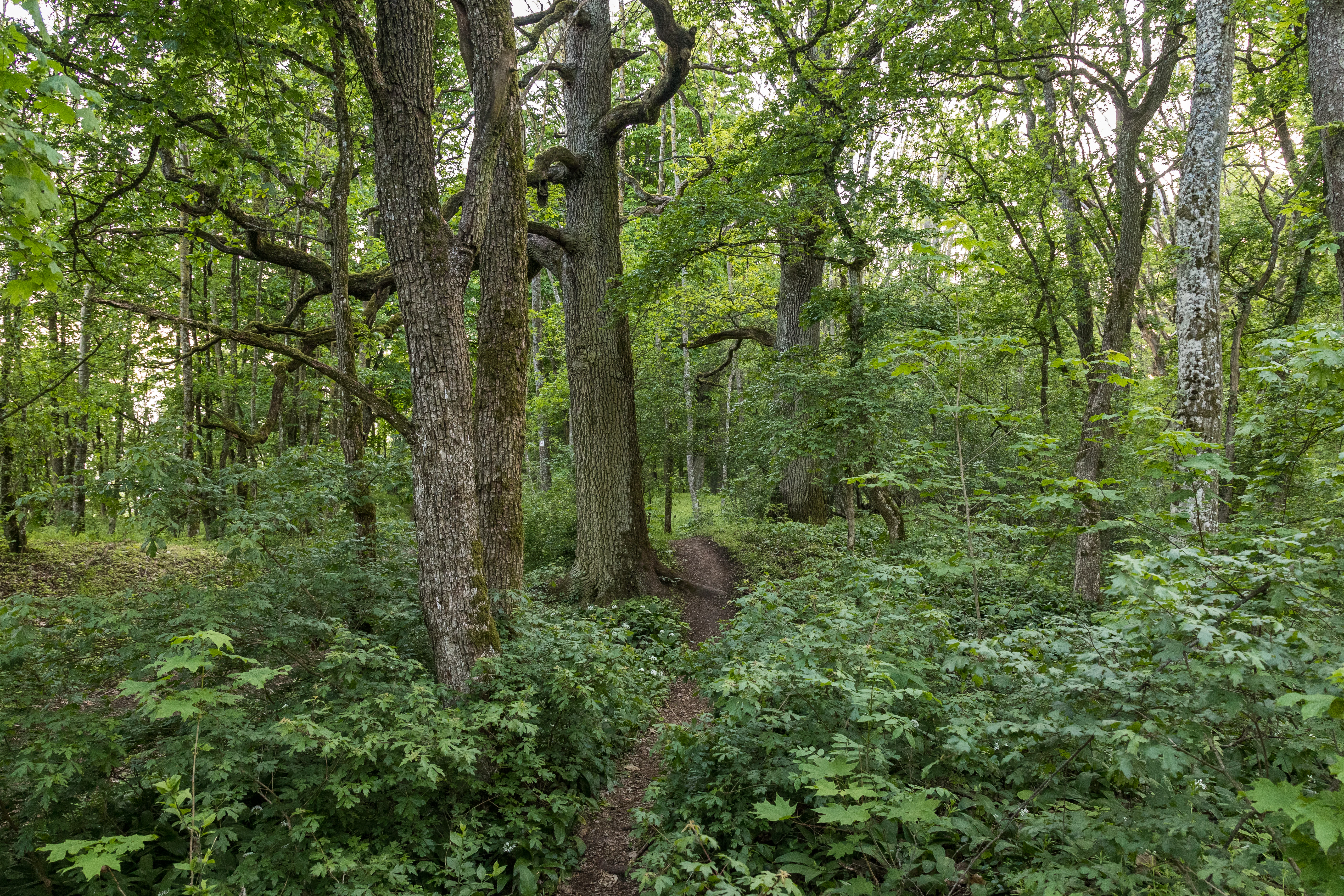
A narrow dirt trail winds through a dense green forest with large mature trees and thick undergrowth.
A narrow dirt path winding through the lush green mixed forest at Schlossbergsattel.

Naturwald Speckfeld history and protected-area timeline

Naturwald Speckfeld was first formally protected in 1978, when 18.1 hectares of state forest in the southern Steigerwald were designated as a Naturwaldreservat. As a Naturwaldreservat, the area was withdrawn from commercial timber harvesting, leaving only interventions related to forest protection and traffic safety. This early designation made Speckfeld one of the older nature forest reserves in Bavaria and established a baseline of several decades of uninterrupted forest development.

The reserve's character changed significantly after the 2019 Bavarian citizens' initiative 'Artenvielfalt & Naturschönheit in Bayern', which called for stronger protection for biodiversity and natural beauty in the state. In response, the Bavarian state government committed to removing around ten percent of the state forest from active use. As part of this political process, Speckfeld was re-designated in 2020 as a Naturwald rather than a Naturwaldreservat, and the protected area was expanded slightly to the south, bringing the total to about 19.54 hectares. Because the land is owned by the Free State of Bavaria, it was integrated into the Bavarian state forest's Naturwald network alongside the other Bavarian nature forest reserves. The site has not been formally reported to the IUCN, and its small size means it likely would not have met the IUCN size criteria, placing it in an unusual position at the international level for a nationally significant strict forest reserve.

Naturwald Speckfeld landscape and geographic character

The reserve lies on the western flanks of the Steigerwald, a low mountain range of rolling forested ridges and valleys that defines much of the landscape between Bamberg and Würzburg in Lower Franconia. Within this broader setting, Speckfeld occupies a part of the Speckfelder Wald, the sectional forest area that takes its name from the historic castle site. Elevation within the reserve ranges from about 358 meters to 423 meters above sea level, with the Schloßberg rising prominently within the protected boundary.

The terrain is shaped by the underlying geology of the southern Steigerwald. The slopes are built from easily erodible, gypsum-bearing claystones capped by thin, harder dolomite beds. These south-facing slopes are unusually steep for the region, giving the reserve a pronounced relief in a relatively small area. The combination of steep terrain, unstable substrate, and the historic castle ruin nearby makes the landscape both physically distinctive and culturally layered. West of the reserve lies the wine town of Iphofen, while Markt Einersheim lies to the southwest and Birklingen to the northeast, so the forest is framed by a traditional rural Franconian cultural landscape of vineyards, villages, and small hamlets.

Naturwald Speckfeld ecosystems, habitats, and plant life

The forest at Speckfeld is a representative example of the mixed broadleaf woodland of the southern Steigerwald, dominated ecologically by oak with an important admixture of hornbeam, small-leaved lime, beech, and conifers. The stand structure reflects a long history of coppice-with-standards management, in which oaks were repeatedly favored as the overstory trees while hornbeam and lime persist from the former coppice layer, and these patterns remain clearly visible in the current species composition.

The vertical profile of the forest is unusually layered for such a small reserve. Oak occupies much of the upper canopy, while hornbeam and small-leaved lime concentrate in the lower and middle layers. On the steep north-facing slope directly below the Speckfeld ruin, ash, sycamore, and Norway maple find their main foothold, taking advantage of the more sheltered, moister conditions. Toward the eastern edge of the reserve, beech becomes a significant component, and along the northern margin spruce takes over, producing a clear transition from broadleaf-dominated core forest to more montane, conifer-influenced forest at the edges.

The geology adds another ecological dimension. The south-facing slopes of gypsum-bearing claystone with dolomite caps, combined with the protected status of the area, support specialized microhabitats: warm, dry rock and soil communities on the slopes; cooler, more mesic broadleaf communities in the shaded draws; and standing structures around the castle ruin, including clefts, cellars, and masonry, that provide roosting and overwintering refuges for bats and cavity-nesting invertebrates.

Naturwald Speckfeld wildlife and species highlights

Naturwald Speckfeld supports a small but ecologically significant assemblage of forest species, with particular importance for bats and birds associated with mature broadleaf forest and the historic castle ruin. The Schloßberg and the Speckfeld ruin within the reserve are especially important: in the winters of 1978/79 and 1979/80, barbastelle bats were recorded in the ruin, and these observations remained the only records of the species in the Landkreis Kitzingen for more than 25 years until the species was detected again in January 2006.

Bechstein's bat has also been recorded regularly, though only in small numbers, in and around the same ruin, and the greater mouse-eared bat uses the area as a winter roost. In the forest itself, middle spotted woodpeckers have been observed, a typical indicator species for mature, structurally rich broadleaf forests with plenty of old and decaying wood. Red kites have been recorded in the surrounding landscape, reflecting the broader importance of the Steigerwald for raptors. The conservation status of the overall site has been assessed as 'B', corresponding to a favorable but not optimal condition.

Naturwald Speckfeld conservation status and protection priorities

Naturwald Speckfeld's central conservation role is to allow a representative piece of southern Steigerwald broadleaf forest to develop without forestry intervention, providing a long-term reference for natural forest dynamics under Central European conditions. Strict protection means that no timber is harvested from the reserve; only measures related to forest protection and public safety are permitted, and these restrictions have been in place either continuously or in their original form since 1978.

The reserve sits inside the EU Natura 2000 network, fully overlapping with the FFH site 'Vorderer Steigerwald mit Schwanberg' and the bird protection area 'Südlicher Steigerwald'. It is also fully contained within the larger 78.2-hectare Naturschutzgebiet 'Schloßbergsattel bei Markt Einersheim', designated in 2002, whose stated objectives include preserving the natural broadleaf forest communities of the Naturwaldreservat taking into account the local geology and soils, gaining scientific insights into the dynamics of these near-natural forests, protecting the unique south-facing steep slopes of gypsum-bearing claystone together with the Speckfeld castle ruin, and safeguarding the habitats of rare and threatened species groups such as reptiles, butterflies, beetles, and hymenopterans.

By integrating these layers of formal protection with long-term state ownership by the Free State of Bavaria and inclusion in the Bavarian Naturwald network, Speckfeld serves as both a practical conservation site and a baseline area against which the development of other, managed forests in the Steigerwald can be compared. Its conservation significance extends beyond the reserve itself because the surrounding FFH and bird-protection zones rely on the strict protection of this core area to maintain their habitat quality.

Naturwald Speckfeld cultural meaning and human context

The reserve carries a clear cultural signature through the Burgruine Speckfeld, the ruined castle that rises in its southwestern part on the 423-meter Schloßberg. The ruin is not merely a scenic backdrop but is integrated into the reserve's ecological and legal framework: it is the very feature that has made the area a focus for bat conservation, and its preservation is one of the named objectives of the overarching Naturschutzgebiet. The Steigerwald itself has long been a forested borderland of the Bishopric of Würzburg, and the small castles of the Speckfelder Wald reflect that medieval territorial history.

The reserve is also part of the broader cultural landscape of Lower Franconia, framed by the wine town of Iphofen to the west, the market town of Markt Einersheim to the southwest, and the village of Birklingen to the northeast. The combination of vineyards, scattered wooded hamlets like Neubauhof, and residual medieval ruins gives the protected forest a strong sense of being embedded in a historically layered agricultural and viticultural region, where strict forest protection represents a deliberate choice to set aside part of this working landscape.

Top sights and standout views in Naturwald Speckfeld

Strict long-term forest protection: a roughly 19-hectare non-harvested forest reserve originating in 1978 and reinforced by 2020 re-designation as part of the Bavarian Naturwald network.

Mixed broadleaf woodland of the southern Steigerwald: oak-dominated stand with hornbeam, small-leaved lime, beech, and conifer influences, with sharp contrasts across a very small area between warm south-facing slopes and cooler shaded draws.

Geological and cultural landmark: gypsum-bearing claystone slopes with dolomite caprock, combined with the Speckfeld castle ruin and the Schloßberg at 423 meters, give the reserve a distinctive profile within the regional forest landscape.

Multi-layered conservation status: full overlap with the FFH area 'Vorderer Steigerwald mit Schwanberg', the bird protection area 'Südlicher Steigerwald', and the Naturschutzgebiet 'Schloßbergsattel bei Markt Einersheim', supporting bats, middle spotted woodpeckers, red kite, and a mosaic of rare invertebrate habitats.

Best time to visit Naturwald Speckfeld

Naturwald Speckfeld is best appreciated in the warmer months when the broadleaf canopy is fully leafed and the steep south-facing slopes are at their most visible. Late spring and early summer bring the strongest contrast between the sun-exposed southern slopes of gypsum-rich claystone, which appear warm and dry, and the cooler, shadier eastern and northern parts of the reserve where beech and spruce dominate. Summer visits also maximize the chance of encountering the dragonfly and butterfly fauna of the surrounding dry grasslands and forest edges, while autumn offers the oak-dominated canopy in full color, which is one of the most distinctive visual signatures of the site. Winter visits have a particular significance for bat interest, as the historic ruin within the reserve has long served as a winter roost for barbastelle, Bechstein's, and greater mouse-eared bats.

Monthly climate preview

Track measured temperature ranges and daily precipitation averages across the protected forest coordinate

Naturwald Speckfeld Climate Normals and Long Term Weather by Month

Long term NASA power records document mean monthly temperatures ranging from sub zero winter lows to warm summer maximums alongside consistent daily precipitation. Reviewing twelve month climatological baselines reveals annual environmental rhythms across the representative coordinate.
Annual mean9 °C
-1 °C19 °C
Jan-1°
Feb
Mar
Apr
May13°
Jun17°
Jul19°
Aug19°
Sep14°
Oct
Nov
Dec
Warmest month
July

19.2 °C

Coolest month
January

-1.1 °C

Wettest month
July

2.6 mm/day

Driest month
April

1.4 mm/day

Park location guide

Geography guide, regional context, and park location map for Naturwald Speckfeld

Naturwald Speckfeld park geography, regions, and map view in Germany

Understand where Naturwald Speckfeld sits in Germany through a broader geographic reading of the surrounding landscape, nearby location context, and its mapped position within the national park landscape.

How Naturwald Speckfeld fits into Germany

Germany is a federal republic in Western and Central Europe with a population of over 83 million across sixteen constituent states. It is Europe's largest economy by nominal GDP and a major global exporter and importer. The capital is Berlin, and the country borders Denmark, Poland, Czech Republic, Austria, Switzerland, France, Luxembourg, Belgium, and the Netherlands.

Wider geography shaping Naturwald Speckfeld in Germany

Germany is located in Western and Central Europe, spanning 357,022 km². It borders Denmark to the north, Poland and the Czech Republic to the east, Austria and Switzerland to the south, and France, Luxembourg, Belgium, and the Netherlands to the west. The country has coastlines on the Baltic Sea and North Sea to the north, with the Alps located in the southern region.

Map view of Naturwald Speckfeld

Use this park location map to pinpoint Naturwald Speckfeld in Germany, understand its exact geographic position, and read its mapped placement within the surrounding landscape more clearly.

Pigeon | © OpenStreetMap contributors

Location context for Naturwald Speckfeld

Bavaria

Visual exploration of mixed broadleaf woodland, gypsum slopes, and ancient forest terrain

Naturwald Speckfeld Photos and Protected Landscape Scenery

Visual records capture the distinctive mixed deciduous woodland, steep gypsum-bearing claystone slopes, and ancient oak-dominated canopies of Naturwald Speckfeld. Detailed photographic coverage reveals the complex terrain and protected forest habitats that define this southern Steigerwald reserve.

A narrow dirt trail winds through a dense green forest with large mature trees and thick undergrowth.

Park atlas

Compare regional forest reserves and protected areas across the Steigerwald hills

Other Parks Near Naturwald Speckfeld and Surrounding Protected Landscapes

Visitors exploring Naturwald Speckfeld can browse other protected forests and nature reserves located throughout the surrounding Lower Franconia region. Examining these adjacent woodland habitats provides broader geographic context for regional forest conservation and local terrain variations.
A watercolor painting of a rolling landscape with scattered trees, grasslands, and soft rolling hills in the background, rendered in pale pastel tones.
Nature reserveUnterfranken
About 9.3 km away#1 closest

Northwest

Sande am Tannenbusch bei Kleinlangheim Nature Reserve: Protected Area and Atlas Overview

Geography of the Steigerwaldvorland sand landscape

Discover the ecological composition of Sande am Tannenbusch bei Kleinlangheim, a nature reserve in Unterfranken defined by its inland sand deposits and fragmented woodland footprint. This site is significant for its sand grassland mosaic, serving as a primary habitat for farmland birds and representing a specialized enclave within the broader Klosterforst region.

Area
0.382 km²
Established
1995
IUCN
IV
Relief
Lowland
Watercolor painting of a green forested landscape with soft rolling hills in the background.
Nature reserveBavaria
About 11 km away#2 closest

Northwest

Naturwald Schwarzacher Tännig: Protected Oak Forest and Regional Landscape Context

Natural forest reserve in the Steigerwaldvorland of Bavaria

Naturwald Schwarzacher Tännig stands as a dedicated nature reserve in Bavaria, focused on the preservation of old-growth oak habitats. By removing this state forest area from active timber production, the reserve supports essential natural regeneration and structural biodiversity. The site functions as a key element within the regional ecological network of the Steigerwald foothills, illustrating the importance of small protected areas for maintaining diverse lowland forest habitats.

Area
0.095 km²
Established
2021
Relief
Upland
Scope
Terrestrial
A watercolor painting of a gentle landscape showing grassy plains, distant rolling hills, and patches of trees.
Nature reserveBayern
About 15 km away#3 closest

Northwest

Sandfluren bei Volkach, Schwarzach am Main und Sommerach: Protected Sand Habitats

Inland dune formations and xerothermic grasslands in Bayern

Located in the Main valley, this nature reserve is defined by its inland sand dunes and drift sand flats that provide a refuge for specialized flora and fauna. As a designated Geotop and Natura 2000 site, it offers a distinct study of arid habitats surviving within an agricultural landscape. Explore the geographic boundaries and terrain mosaic that make this protected area a noteworthy feature of the Lower Franconian environment.

Area
1.048 km²
Established
1989
IUCN
IV
Watercolor painting showing rolling green hills, trees in the midground, and purple-tinted mountains in the background against a white backdrop.
Nature reservePrichsenstadt
About 17 km away#4 closest

North

Naturwald Krackentännig Nature Reserve: A Protected Forest Landscape in Northern Bavaria

Geography of the Steigerwaldvorland and Gänsseegraben valley floor

Situated near Prichsenstadt, Naturwald Krackentännig acts as a refuge for ash and alder trees that thrive in the moist soils of the Lower Franconian countryside. This nature reserve provides a critical example of undisturbed forest development, showcasing a specialized ecosystem within the rolling hills of the Steigerwaldvorland and a commitment to preserving small-scale woodland habitats.

Area
0.026 km²
Established
2021
Relief
Lowland
Scope
Terrestrial
A watercolor painting showing a panoramic landscape with light green hills, tall slender trees in the foreground, and soft washes of color depicting a natural forest scene.
Nature reserveBavaria
About 20 km away#5 closest

East

Naturwald Schlag Nature Reserve: Geographic Atlas and Protected Forest Context in Bavaria

A dedicated site for natural forest development and regional conservation mapping

Naturwald Schlag serves as a vital case study for non-intervention forestry in the Steigerwald region of Upper Franconia. Located near the locality of Heuchelheim, this reserve protects a mature stand of pine, beech, and oak. MoriAtlas provides a clear view of its formal designation and geographic position within the broader Bavarian natural forest network.

Area
0.008 km²
Established
2021
Relief
Upland
Climate
Temperate
Watercolor painting of a forest landscape with a grassy clearing and distant hills, rendered in soft green and pink tones.
Nature reserveGermany
About 21 km away#6 closest

Northeast

Naturwald Waldhaus: Geographic Mapping of an Ancient Beech Reserve in Steigerwald, Bavaria

Protected natural woodland and forest biodiversity in northern Germany.

Naturwald Waldhaus stands as a prime example of a protected forest in the Steigerwald, recognized for its exceptionally old beech stands and documented saproxylic beetle populations. This nature reserve provides essential ecological continuity within the Bamberg district, representing a rare, undisturbed woodland landscape that serves as a cornerstone for forest research in southern Germany.

Area
1.062 km²
Established
1978
Relief
Upland
Climate
Temperate
A soft watercolor illustration of rolling hills and gentle terrain in shades of pale green and muted earth tones against a white background.
Protected landscapeMittelfranken
About 22 km away#7 closest

South

Naturpark Frankenhöhe Protected Landscape: Geography, Map, and Regional Conservation Context

Explore the diverse natural terrain of the Mittelfranken region in Bavaria.

Naturpark Frankenhöhe serves as a significant protected landscape in western Mittelfranken, encompassing a unique mosaic of forests, vineyards, and agricultural valleys. This geographic entity is shaped by the European Main Watershed, where rivers divide between the Rhine and Danube systems. Its terrain provides a study in transitions, from higher forested crests to open orchard meadows that define the local Bavarian countryside.

Area
1,104.06 km²
Established
1974
Relief
Mixed relief
Climate
Temperate
A soft, light watercolor painting of a pastoral landscape with rolling green fields, scattered trees, and distant hills under a pale yellow sky.
Nature reserveBavaria
About 22 km away#8 closest

Northwest

Sandgrasheiden am Elgersheimer Hof Nature Reserve and Main Valley Protected Landscapes

Rare sand grassland geography and conservation status in Lower Franconia, Bavaria

Sandgrasheiden am Elgersheimer Hof protects two distinct parcels of sand grassland, a rare habitat type that provides a refuge for specialized plant communities like Jurinea cyanoides. Situated within the Maintal between Schweinfurt and Dettelbach, the reserve creates a critical ecological link between agricultural plains and riverine meadow landscapes. This atlas entry details the geographic context and habitat mosaic of this significant Bavarian nature reserve.

Area
0.035 km²
Established
1999
IUCN
IV

Common questions about visiting, size, designation, and location context for Naturwald Speckfeld

Naturwald Speckfeld FAQs for park facts, access, geography, and protected area context

Find quick answers about Naturwald Speckfeld, including protected-area facts, park geography, trail and visitor context, and how the park fits into its surrounding country and regional landscape.
MoriAtlas Explorer

Continue Your Protected Areas Search Across the Global Atlas

Deepen your exploration by continuing the structured search for national parks and protected areas worldwide. Utilize the comprehensive filtering capabilities to compare different conservation landscapes and refine your understanding of global park geography. Discover more about the distribution and characteristics of protected natural areas.

Global natural geography