
Mori Atlas logo
Nature reserveNaturwald Wasserwand

A detailed look at the mature oak and beech forest dynamics within the Bruderwald plateau landscape.

Naturwald Wasserwand Nature Reserve: Exploring Protected Woodland Geography in Upper Franconia, Bayern

Naturwald Wasserwand serves as a significant protected forest area located within the Bruderwald landscape south of Bamberg, Bayern. This nature reserve stands as a critical example of Bavarian forest conservation, where mature stands of oak, beech, and winter linden are left to natural succession. The site offers a clear view into the ecological character of Upper Franconian lowland woodlands, serving as both a local habitat and a case study in non-managed forest development.

BavariaUpper FranconiaBambergnatural forest reserveNaturwaldbroadleaf forest
A flat, colorful vector-style illustration of a forested mountain valley with a waterfall cascading down a cliff into a river.

Naturwald Wasserwand

Nature reserve

Park overview

Structured park overview, official facts, and landscape profile for Naturwald Wasserwand

Naturwald Wasserwand park facts, protected area profile, and essential visitor context

Review the core facts for Naturwald Wasserwand, including designation, size, terrain, visitor scale, habitats, and operating context in one park-focused overview.

About Naturwald Wasserwand

Naturwald Wasserwand is a compact but ecologically meaningful forest reserve in the German state of Bavaria. It lies within the Bruderwald, a forested area that extends south of the UNESCO-listed city of Bamberg and serves as both a local recreation zone and a continuous woodland landscape connecting Bamberg with the surrounding Upper Franconian countryside. The reserve itself covers roughly 29 hectares and is one of the larger Naturwald areas in Upper Franconia.

The natural forest was formally designated in 2022 under Article 12a of the Bavarian Forest Act, which governs Naturwaldreservate and Naturwaldflächen across the state. Its establishment was part of a broader policy push by the Bavarian state government to set aside approximately ten percent of state forest from active management. This pledge emerged in the wake of the 2019 Bavarian biodiversity referendum, popularly known as "Rettet die Bienen" ("Save the Bees"), which called for stronger measures to protect habitats and species in the state.

Unlike a typical commercial forest, Naturwald Wasserwand is intentionally left to undergo natural ecological development. Only measures related to forest protection and public safety, such as the removal of hazardous trees along trails, are permitted; harvesting, timber extraction, and other forestry interventions are otherwise excluded. The Bayerische Staatsforsten, Bavaria's state forest administration, classify the area as an old, near-natural woodland, with the canopy dominated by oak (Eiche), European beech (Buche), and small-leaved or winter linden (Winterlinde).

The reserve sits within the Natura 2000 site known as "Bruderwald mit Naturwaldreservat Wolfsruhe," an FFH (Fauna-Flora-Habitat) area that recognizes the broader conservation value of the Bruderwald forests. Naturwald Wasserwand is closely linked to two neighboring protected woodland areas: Naturwald Wolfsruhe to the west, which has been excluded from forestry use for many years, and Naturwald Brand to the north. Together, these three Naturwald units form a contiguous network of protected forest within the Bruderwald, enhancing habitat continuity and ecological resilience in the landscape surrounding Bamberg.

Because it is easily accessible from the city and lies within the established Bruderwald recreation area, Naturwald Wasserwand also plays a quiet but important role in connecting local residents with native woodland. Its relatively modest size belies its broader significance as a representative example of how Bavaria is reshaping its relationship between state forestry and natural forest protection.

Quick facts and research context for Naturwald Wasserwand

Naturwald Wasserwand is a designated natural forest (Naturwald) of about 29 hectares within the Bruderwald south of Bamberg, in Upper Franconia, Bavaria. It was formally established as a protected forest area in 2022 under the Bavarian Forest Act, following the state's pledge tied to the 2019 biodiversity referendum known as "Rettet die Bienen."

The reserve is managed by the Bayerische Staatsforsten (Bavarian State Forests) and is part of the larger Natura 2000 FFH site "Bruderwald mit Naturwaldreservat Wolfsruhe." It is classified as a Habitat/Species Management Area under IUCN Category IV, and the forest is characterized as an old, near-natural stand dominated by oak, beech, and small-leaved linden.

Protection and recognition

Examine terrestrial protection metrics and official designation records for this conservation area.

Naturwald Wasserwand Protection Status and International Recognition Data

Naturwald Wasserwand maintains a documented terrestrial protection scope without imported international recognition sources. Structured preservation metrics and administrative records provide clear baseline data for ongoing conservation analysis.

Protection details

Protection scope
Terrestrial
Park context

Deeper park guide and search-rich context for Naturwald Wasserwand

Naturwald Wasserwand history, landscape, wildlife, and travel context

Explore Naturwald Wasserwand through its history, landscape character, ecosystems, wildlife, conservation priorities, cultural context, and seasonal travel timing in a structured park guide built for atlas discovery and search intent.

Why Naturwald Wasserwand stands out

Naturwald Wasserwand is known as an example of Bavaria's policy of withdrawing portions of state forest from active timber management in order to protect old, near-natural woodland. The reserve is recognized for its mature mixed stand of oak, beech, and winter linden, a forest composition that reflects the historical character of the Bruderwald around Bamberg. The site also stands out for its proximity to an urban center; while most visitors associate nature reserves with remote mountain or wetland settings, Naturwald Wasserwand sits within walking distance of a historic Franconian city. This combination of ecological significance and urban accessibility makes it a notable case study in Bavarian forest conservation policy.
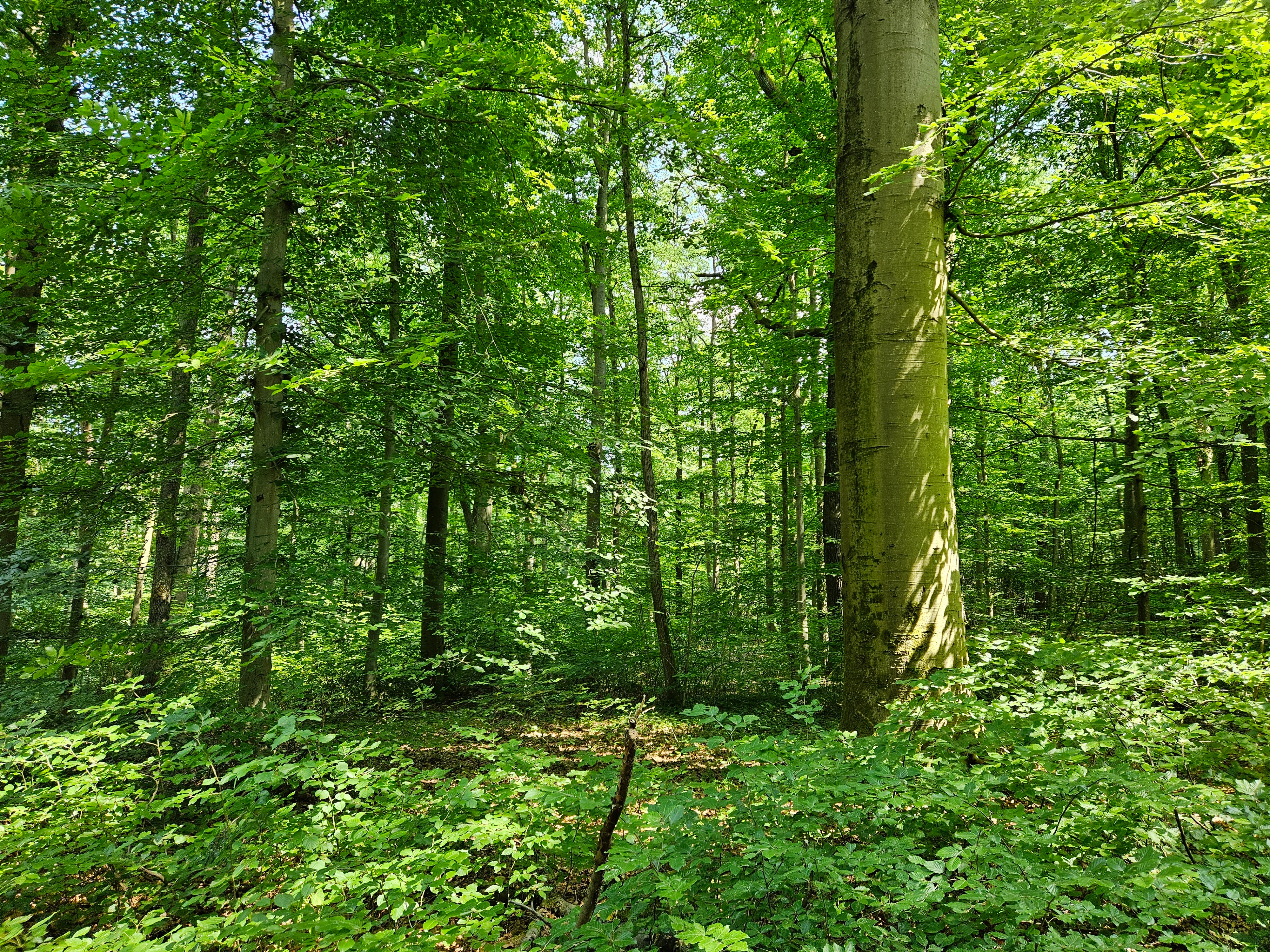
A dense, green deciduous forest with tall tree trunks and a thick canopy, with ground level vegetation visible in the foreground.
Lush deciduous forest interior at Naturwald Wasserwand.

Naturwald Wasserwand history and protected-area timeline

The history of Naturwald Wasserwand is closely tied to a shift in Bavarian forest policy that accelerated in the early 2020s. Before its formal designation, the site had already been identified by the Bayerische Staatsforsten as a so-called Class 1 forest (Klasse-1-Wald), meaning that it had effectively been withdrawn from active timber harvesting for conservation reasons prior to receiving its Naturwald status.

The decisive policy push came from the Volksbegehren Artenvielfalt, the 2019 Bavarian biodiversity referendum nicknamed "Rettet die Bienen." In response to this large public campaign, the Bavarian state government announced that around ten percent of the state forest would be taken out of productive management and left for natural development. Naturwald Wasserwand is one of the resulting designations, and it was formally established as a Naturwald in 2022 under Article 12a of the Bavarian Forest Act.

Its earlier withdrawal from forestry already made the transition to Naturwald status a logical step. Rather than a newly protected site, the reserve represents the consolidation, formalization, and long-term legal protection of an area that had already been functioning as a de facto ecological refuge within the Bruderwald.

Naturwald Wasserwand landscape and geographic character

Naturwald Wasserwand occupies a gently rolling section of the Bruderwald plateau south of Bamberg, in the Upper Franconian landscape of northern Bavaria. The terrain here is typical of the region's suburban woodlands: low hills, broad valleys, and a continuous forest canopy that has historically shaped the visual and recreational character of the area around Bamberg.

Within this setting, the reserve itself is a contained patch of mature broadleaf woodland, framed by forests that extend in multiple directions. The Bruderwald as a whole serves as both an ecological corridor and a recreational landscape for the surrounding villages of Bug, Pettstadt, Strullendorf, Waizendorf, and Höfen. The reserve's position within this matrix gives it a transitional character, sitting between the urban edge of Bamberg and the more agricultural rural landscapes further south.

The defining physical character of the site is set by its tree composition rather than dramatic topography. The mature oak, beech, and linden canopy creates a relatively closed and shaded forest interior, with limited open ground and an understory shaped by natural litter fall rather than active management. This gives the reserve a quiet, undisturbed woodland atmosphere despite its proximity to a sizable historic city.

Naturwald Wasserwand ecosystems, habitats, and plant life

Ecologically, Naturwald Wasserwand is significant as a representative broadleaf forest stand of the Upper Franconian lowlands. The site is dominated by oak (Eiche), European beech (Buche), and small-leaved or winter linden (Winterlinde), a combination typical of older, near-natural mixed forests in central European lowland settings.

Because the reserve is designated to allow natural forest development without timber extraction or active forestry, it functions as a living laboratory for how such mixed broadleaf stands evolve when human intervention is largely removed. Deadwood is allowed to accumulate, natural regeneration proceeds without planting, and the structural complexity of the forest increases over time.

The reserve is also integrated into the larger Natura 2000 framework through the FFH site "Bruderwald mit Naturwaldreservat Wolfsruhe," meaning that its ecological role is recognized on a European scale. It forms one node in a small network of Naturwald areas within the Bruderwald, alongside Naturwald Wolfsruhe and Naturwald Brand, which together increase habitat continuity for woodland species across the southern edge of Bamberg.

Naturwald Wasserwand wildlife and species highlights

The available sources do not provide detailed species-level information about the fauna of Naturwald Wasserwand. As a connected patch of mature deciduous woodland set aside for natural development within a broader Natura 2000 FFH area, the reserve would be expected to support the typical woodland species of central European lowland forests, including forest birds, small mammals, and a wide range of invertebrates associated with standing and fallen deadwood.

However, because the source material does not detail specific species, populations, or notable animal records, a distinct wildlife section cannot be constructed without risking unsupported detail. The site's broader biodiversity value is therefore best understood through its ecological setting and conservation status rather than through any specific wildlife inventory.

Naturwald Wasserwand conservation status and protection priorities

The conservation significance of Naturwald Wasserwand lies in its role as part of Bavaria's transition from timber-producing state forest toward a landscape that includes substantial areas of protected, freely developing woodland. By removing the site from active forestry under the framework of Article 12a of the Bavarian Forest Act, the state has committed the area to a process of natural ecological succession, allowing forest communities, soil processes, and habitat structures to develop without human-driven extraction.

The reserve's inclusion within the Natura 2000 site "Bruderwald mit Naturwaldreservat Wolfsruhe" reinforces its conservation standing at the European level. In combination with the adjacent Naturwald Wolfsruhe and Naturwald Brand, it contributes to a network of protected forest patches that improve habitat connectivity, support deadwood-dependent species, and preserve a representative example of the traditional Upper Franconian mixed broadleaf forest.

Waterwand's history also mirrors a wider shift in Bavarian environmental policy. Its 2022 designation came directly out of the political response to the 2019 "Rettet die Bienen" referendum, illustrating how public demand for biodiversity protection translated into formal landscape conservation measures across the Bavarian state forest estate.

Naturwald Wasserwand cultural meaning and human context

Although Naturwald Wasserwand is itself a relatively new designation, the Bruderwald in which it sits has long been part of the cultural and recreational geography of Bamberg. The woodlands south of the historic city have traditionally provided space for walking, hunting, and quiet retreat, and they remain an important local recreation area today.

The reserve's proximity to the UNESCO-listed old town of Bamberg gives it a particular cultural setting. While the city is celebrated for its baroque architecture and its intact historic urban fabric, the surrounding Bruderwald anchors the city within a broader green landscape that continues to shape daily life for residents of Bug, Pettstadt, Strullendorf, Waizendorf, and the southern Bamberg districts. The Naturwald reflects a modern cultural shift in which nearby citizens increasingly expect formally protected, ecologically functioning nature within easy reach of their city.

Top sights and standout views in Naturwald Wasserwand

Naturwald Wasserwand is one of the larger Naturwald sites in Upper Franconia and an important node in the emerging network of protected forests around Bamberg. It stands out for its mature oak-beech-linden composition, its legal commitment to natural development without timber harvesting, and its position within both the Bavarian Naturwald system and the European Natura 2000 network.

Best time to visit Naturwald Wasserwand

Because Naturwald Wasserwand is a quiet, lowland broadleaf forest near the city of Bamberg, its atmosphere varies with the seasons in the way typical central European woodlands do. Spring brings fresh leaf growth on the beech and oak canopy, together with the songbirds and ground flora associated with the awakening forest. Summer offers dense, deeply shaded conditions under the mature canopy, with cool woodland interiors even on warm days. Autumn is marked by the coloration of the broadleaf canopy and the natural litter fall that drives the forest's nutrient cycle. Winter exposes the structure of the trees, making deadwood, trunk forms, and the reserve's edges more visible. Each season expresses a different aspect of the same old-growth stand, and the reserve's accessibility from Bamberg means it can be visited comfortably throughout the year.

Monthly climate preview

Long-term monthly temperature and precipitation rhythm for Naturwald Wasserwand

Naturwald Wasserwand Climate Normals and Annual Temperature Patterns

Naturwald Wasserwand records measured long-term temperatures and daily precipitation rates across a representative coordinate at 335.81 meters elevation. Examining the complete twelve-month statistical record provides detailed context for regional climate normals and monthly variations.
Annual mean9 °C
-1 °C19 °C
Jan-1°
Feb
Mar
Apr
May13°
Jun17°
Jul19°
Aug19°
Sep14°
Oct
Nov
Dec
Warmest month
July

19.4 °C

Coolest month
January

-1.2 °C

Wettest month
July

2.5 mm/day

Driest month
April

1.3 mm/day

Park location guide

Geography guide, regional context, and park location map for Naturwald Wasserwand

Naturwald Wasserwand park geography, regions, and map view in Germany

Understand where Naturwald Wasserwand sits in Germany through a broader geographic reading of the surrounding landscape, nearby location context, and its mapped position within the national park landscape.

How Naturwald Wasserwand fits into Germany

Germany is a federal republic in Western and Central Europe with a population of over 83 million across sixteen constituent states. It is Europe's largest economy by nominal GDP and a major global exporter and importer. The capital is Berlin, and the country borders Denmark, Poland, Czech Republic, Austria, Switzerland, France, Luxembourg, Belgium, and the Netherlands.

Wider geography shaping Naturwald Wasserwand in Germany

Germany is located in Western and Central Europe, spanning 357,022 km². It borders Denmark to the north, Poland and the Czech Republic to the east, Austria and Switzerland to the south, and France, Luxembourg, Belgium, and the Netherlands to the west. The country has coastlines on the Baltic Sea and North Sea to the north, with the Alps located in the southern region.

Map view of Naturwald Wasserwand

Use this park location map to pinpoint Naturwald Wasserwand in Germany, understand its exact geographic position, and read its mapped placement within the surrounding landscape more clearly.

Pigeon | © OpenStreetMap contributors

Location context for Naturwald Wasserwand

BayernOberfranken

Visual reference for the mature oak, beech, and linden canopy of Upper Franconia.

Naturwald Wasserwand Photos and Protected Forest Landscape Scenery

Visual documentation captures the closed canopy and undisturbed woodland character of Naturwald Wasserwand near Bamberg. Examining protected area photography reveals the mature mixed tree composition and lowland forest terrain that define Bavarian conservation policy.

A dense, green deciduous forest with tall tree trunks and a thick canopy, with ground level vegetation visible in the foreground.

Park atlas

Compare adjacent woodland reserves and regional forest landscapes across northern Bavaria.

Other Parks Near Naturwald Wasserwand and Protected Areas in Upper Franconia

Visitors exploring Naturwald Wasserwand can examine other protected forests and nearby woodland reserves across the Bruderwald plateau. Comparing these adjacent habitats reveals broader conservation patterns within the Upper Franconian regional landscape.
Watercolor painting of a gentle valley landscape featuring soft green hills, mixed deciduous and coniferous trees, and a winding stream.
Nature reserveOberfranken
About 1.3 km away#1 closest

West

Naturwald Wolfsruhe Protected Forest Reserve: An Oberfranken Geography and Atlas Overview

Analyzing the forest composition and Keuper escarpment landscape

Naturwald Wolfsruhe is a protected nature reserve in Oberfranken that showcases a unique forest ecosystem shaped by former coppice-with-standards management. This site offers valuable insight into the biodiversity of the Franconian Keuper-Lias region, where pedunculate oak stands and varied soil substrates create a distinct natural landscape south of Bamberg.

Area
0.465 km²
Established
1978
IUCN
IV
Relief
Lowland
A soft watercolor painting of a winding river flowing through green rolling hills and meadows under a hazy, bright sky.
Protected landscapeBavaria
About 6.6 km away#2 closest

East

Naturpark Fränkische Schweiz, Frankenjura: An Atlas of Bavarian Karst and Forested Landscapes

Protected landscape geography within the northern Franconian Jura.

Naturpark Fränkische Schweiz, Frankenjura is a landmark protected area covering over 2,300 square kilometers across Bavaria. Its terrain is defined by a rhythmic sequence of limestone plateaux, winding river valleys, and dolomite formations, balanced by the quieter, pine-dominated reaches of the Veldensteiner Forst. This atlas entry details the park's geological complexity and its significant role in regional conservation.

Area
2,335.44 km²
Established
1968
Relief
Upland
Climate
Temperate
Nature reserveLandkreis Haßberge
About 24 km away#3 closest

West

Schulterbachtal Nature Reserve: Mapped Geography and Protected Wetland Landscapes in Bavaria

A focused analysis of the Steigerwald wetland and brook habitats

Schulterbachtal occupies a protected valley floor within the Haßberge district, characterized by its near-natural stream, extensive wet meadow communities, and characteristic alder-ash woodland belts. As a key segment of the northern Steigerwald ecosystem, this site demonstrates the ecological significance of managed cultural landscapes and provides a detailed view of its hydrological and vegetative terrain.

Area
0.341 km²
Established
1990
IUCN
IV
A watercolor painting showing a panoramic landscape with light green hills, tall slender trees in the foreground, and soft washes of color depicting a natural forest scene.
Nature reserveBavaria
About 27 km away#4 closest

Southwest

Naturwald Schlag Nature Reserve: Geographic Atlas and Protected Forest Context in Bavaria

A dedicated site for natural forest development and regional conservation mapping

Naturwald Schlag serves as a vital case study for non-intervention forestry in the Steigerwald region of Upper Franconia. Located near the locality of Heuchelheim, this reserve protects a mature stand of pine, beech, and oak. MoriAtlas provides a clear view of its formal designation and geographic position within the broader Bavarian natural forest network.

Area
0.008 km²
Established
2021
Relief
Upland
Climate
Temperate
Nature reserveLandkreis Haßberge
About 30 km away#5 closest

West

Naturwald Wotansborn: A Protected Old-Growth Beech Reserve in the Heart of the Steigerwald

Ancient forest geography within the Haßberge district

Naturwald Wotansborn is a protected woodland enclave that preserves centuries-old beech trees and high concentrations of deadwood habitat. Located in the Steigerwald of Landkreis Haßberge, this reserve offers a window into natural forest cycles, housing the historic Wotansborn spring and a vital corridor for amphibian life along the Erlesbach stream.

Area
0.033 km²
Established
2020
IUCN
IV
Relief
Upland
A horizontal watercolor painting showing soft, light-colored rolling hills and distant mountain ridgelines, with clusters of green trees in the foreground.
Nature reserveBavaria
About 31 km away#6 closest

Northeast

Naturwald Vierzehnheiligen Protected Area and Bavarian Forest Geography

Nature reserve featuring old-growth deciduous stands and limestone slope terrain

Naturwald Vierzehnheiligen comprises a vast, strictly protected forest in Upper Franconia, Germany. Spanning the foothills of the northern Franconian Jura, this reserve is defined by its structurally diverse canopy, moist ravine habitats, and limestone geological formations. It provides a essential study in non-intervention woodland management, serving as a critical refuge for broadleaved-forest species within the regional Bavarian landscape.

Area
5.413 km²
Established
2020
Relief
Upland
Climate
Temperate
A soft watercolor painting of a rolling forested landscape with green hills and trees on a white background.
Nature reserveBayern
About 31 km away#7 closest

West

Naturwald Knetzberge-Böhlgrund Nature Reserve and Steigerwald Forest Geography

A mapped overview of protected broadleaf forests in Lower Franconia.

Spanning over 800 hectares, Naturwald Knetzberge-Böhlgrund is a major protected forest entity in the Steigerwald that integrates mature stands, deadwood habitats, and steep valley topographies. This area offers a unique perspective on natural forest succession and ecological preservation within the German landscape, marked by its distinct sandstone ridges and high biodiversity.

Area
8.474 km²
Established
2020
Relief
Mountain
Climate
Temperate
Watercolor painting of a forest landscape with a grassy clearing and distant hills, rendered in soft green and pink tones.
Nature reserveGermany
About 33 km away#8 closest

West

Naturwald Waldhaus: Geographic Mapping of an Ancient Beech Reserve in Steigerwald, Bavaria

Protected natural woodland and forest biodiversity in northern Germany.

Naturwald Waldhaus stands as a prime example of a protected forest in the Steigerwald, recognized for its exceptionally old beech stands and documented saproxylic beetle populations. This nature reserve provides essential ecological continuity within the Bamberg district, representing a rare, undisturbed woodland landscape that serves as a cornerstone for forest research in southern Germany.

Area
1.062 km²
Established
1978
Relief
Upland
Climate
Temperate

Common questions about visiting, size, designation, and location context for Naturwald Wasserwand

Naturwald Wasserwand FAQs for park facts, access, geography, and protected area context

Find quick answers about Naturwald Wasserwand, including protected-area facts, park geography, trail and visitor context, and how the park fits into its surrounding country and regional landscape.
MoriAtlas Explorer

Continue Your Protected Areas Search Across the Global Atlas

Deepen your exploration by continuing the structured search for national parks and protected areas worldwide. Utilize the comprehensive filtering capabilities to compare different conservation landscapes and refine your understanding of global park geography. Discover more about the distribution and characteristics of protected natural areas.

Global natural geography